

For people with the itch for a challenge but with limited time to devote to it, state trails offer great opportunities. Closer to home, thru-hiking or section hiking is manageable, and you get to see parts of your state that you otherwise speed by on your way to somewhere else. Shuttles and trail support may not be as readily available as on the AT or PCT, but with some due diligence you might uncover some trail angels and friends to lend a hand.
From 2009 to 2011, I section hiked North Carolina’s Mountains-To-Sea Trail from the Great Smoky Mountains to Jockey’s Ridge State Park on the Outer Banks, walking the footpaths with Danny Bernstein and biking most of the backroad miles. The experience was a treasure trove of special moments. One was hiking miles in the sand to the Cape Hatteras Lighthouse, which I had never visited despite my 30+ years as a North Carolina resident.
As I mentioned in a previous post, my buddy Carol asked me to join her in hiking a section of South Carolina’s state trail, the Palmetto Trail. First I went a-Googling. The trail’s website is easy to read for general info but interpreting maps is a little challenging. [We learned during our hike that the website is not always up-to-date.] The trail is divided neatly into sections called “passages” and we were interested in the Swamp Fox Passage. This looks like fun…wait a minute…did you say swamp? And did you say January?
From the website: “At 47 miles, the Swamp Fox Passage is the longest section of the cross-state Palmetto Trail. The passage traverses four distinct ecosystems through Francis Marion National Forest, including swamps made famous as hideouts of Revolutionary War hero Francis Marion. Mature long-leaf pine forests are home to the endangered red-cockaded woodpecker. Grassy savannas with abundant wildlife border Dog Swamp and Turkey Creek, and a cypress pool footbridge offers excellent views of the impressive Wadboo Swamp. Three trailheads provide users with options for one long trek or shorter day trips. Any access point makes for an enjoyable trip and diverse views.”
The Swamp Fox is best hiked in wintertime when ticks, bugs, snakes and alligators are less active (SAY WHAT?)
Being an Appalachian trail thru-hiker (2016), Carol was ready to thru-hike this thing until I suggested that since we were both bringing cars to the party, we could, with a little bit of logistics 101, tackle it as dayhikes and car shuttles. We could hike more miles each day with light daypacks, spend a little time moving cars, and enjoy luxury car camping. Yes, ma’am!
Figuring mileages, scoping out campsites, downloading Avenza maps (okay, Carol doing the heavy lifting), we decided to include the Awendaw Passage (the last 7 miles to the coast) in our adventure, for a total of 4 nights and 4 days.
On a dark and stormy January night, I found myself meeting Carol at the western end of Swamp Fox Passage’s trailhead on Hwy 52 near Moncks Corner, SC. It wasn’t a for-real campsite, just a muddy parking area with room for a couple of tents. I arrived just before dark, saw that Carol was already settling in, so I hurried to get my tent up. We ate supper in Carol’s car and discussed logistics. Neither of us was familiar with the area, but she had done a lot of map-studying for access points and how to get to them.

We spent a noisy night right beside the busy 4-lane road. The wind blew in a cold front with a little bit of rain, not enough to make me want to go home. I slept a little (Tylenol PM and earplugs) but was awake before 6:00 a.m. Might as well pack up and get on the trail.
Rather than hiking the Swamp Fox Passage in purist style, eastbound from Hwy 52 to the end point, we opted to minimize moving cars each day. For Day 1, that meant driving my car to Cordesville Road where the trail crosses at Mile 33, then walking westbound back to Carol’s car at Hwy 52.
Leaving a car in a remote area is not usually my preference, but the logistics won out. Cordesville Road was a very good gravel forest road and I felt okay with leaving it at a pullout where the trail crossed. I checked the lights and locks a few times, made sure the keys were in my pants pocket, and we were off…which way now? Oh, yes, that way.
We started at 7:45 a.m., me tracking our route with GAIA. Carol had the Avenza app for reference and she was tracking mileage on her Runkeeper.


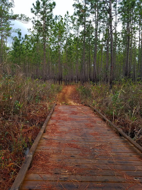
General comments on the trail: Totally flat terrain. The maintenance folks mow a wide path through the grasses, not quite side by side walking but not a skinny footpath. There are some broad boardwalks, some old bridges, some new bridges, but mostly single-wide elevated boards crossing areas that stay flooded. Unfortunately, the majority of these are old and rotted, but what can you do where wet is the norm?


Trail signs and blazes were abundant. Not sure what the flagging tape is for.
At first the water on the trail was surprising. We adjusted to high alert and problem solving – the goal was not to immerse boots - side walking on the edges of the puddles/ponds, learning to test out hummocks of grass (mostly thigh high).
Walking on boards along the wet edges – sometimes the boards disappeared.


At times making our own path, bushwhacking for wide detours around large flooded stretches and watching each step in the high grass because the water was really everywhere.


All this slowed us down and we were no longer optimistic about a 2+ miles-per-hour pace. Hope it’s not 4 days of wading! But mostly we walked through serene forests of dark pine trees unlike what we’re used to in the mountains. Quiet and still.


Baby longleaf pines make me smile, shoulder height and looking like aliens
with a mop of bright green needle-hair

At the time of our hike (January 2021), the U.S. Forest Service website had detour instructions around a section due to a missing bridge over Cane Gully Branch and we spent time making sure we understood the detour. In fact, I worried about this because it required road walking. But when Carol and I drew close to the area there was no signage about a detour, and the bridge was supposed to be only one-third of a mile ahead. Carol said, “Let’s go look and see.” Sure enough, there was a big, beautiful, intact bridge and we were glad we took the chance. If we had been hiking from the other direction, we would have followed the detour instructions in an abundance of caution and missed seeing the bridge.
[When planning a hike on the Swamp Fox Passage, be sure to include the Forest Service’s website in your research. Give them a call if you feel you need assurances of trail conditions.]
 The not-missing Cane Gully Bridge
 Two roads diverged in a wood and we… we followed the one with the trail blazes
Wadboo Swamp is a true swamp, deep tannic black water, very still, barely perceptible flow, quiet, eerie, cypress trees and cypress knees. There is extensive infrastructure of boardwalks and bridges, a massive one over the main creek channel, and a put-in for the Wadboo waterway, which I will never paddle unless multiple guides are with me. I’ve read that this area can be impassable after heavy rain events. You will not hear that firsthand from me!


At the U.S. 17 Alt road crossing, Carol and I encountered our biggest obstacle: an enormous pond that stretched across 30 yards into thick brush on either side of the submerged trail. It appeared that vehicle access had made it that way. Trash was strewn all around, making us wary of removing boots to wade across (glass and other sharp ouchy things in the murky water?)

Carol went right, I went left, and we both bushwhacked around the pond, hurrying and trying not to think about what we might be stepping in. Each of us fared about the same. A couple of steps in water over tops of my boots, not terrible, but enough to seep through the old leather and get my socks wet. Cold, damp toes the rest of the day.
Not far past that point, we came upon a CCC group, an adult volunteer supervising some teenagers building bridges (three mostly complete and one staked out). Hiker friends, having you thanked any trail builders and maintainers today?

The stretch between U.S. 17 Alt and 52 was the wettest slog of our entire trip – thank goodness! What would we have thought if we had started at this end? Glad we got the worst over on the first day.
We reached Carol’s car at 3:15 p.m. During the day we had debated how to approach tomorrow’s hiking and we settled on leaving my car parked on Cordesville Road and hiking westbound to it from tonight’s new campsite near Mile 19. With that plan in mind, we stopped at my car and transferred my camping gear and food into hers.
So where are we camping? In a churchyard.
As part of her research, Carol connected with Marie, a trail angel and knowledge keeper for the Swamp Fox Passage. On a tip from her, Carol contacted the pastor of Eccles Church in Huger, SC (located next to the trail, near the intersection of Eccles Church Road and Conifer Road). He granted us permission to camp on the grounds for 2 nights.
The original church building dates from 1882. There is a small modern brick building on the property behind it, and a fenced cemetery further back. (Read more about the church here.)
My first time camping on the lawn beside a church – very quiet, flat grassy space to pitch tents – dare I say “heavenly”?


We fired up camp stoves and had a hot meal, them got prepared for the next day’s hike. The sky was clear and cold, the temperature predicted to dip into the low 30’s. We quickly got chilled sitting around, so we retreated to our tents by 7:00 p.m.
A full wolf moon, like sleeping in the spotlights on a ball field, daylight inside my tent! Worried about being too cold, the temp dropped to 29 degrees, but I was toasty warm in my down sleeping bag cocoon. Dreamed about hiking in the water, but we know we can do this.
“In Nature there is no dirt, everything is in the right condition; the swamp and the worm, as well as the grass and the bird – all is there for itself.” ~Berthold Auerbach
No comments:
Post a Comment