Tuesday, November 22, 2022

North Carolina State Parks: Occoneechee Mountain State Natural Area

Occoneechee Mountain State Natural Area – 2/1/22 – 4 miles 

On the way from here to there, I took a little time to visit Occoneechee Mountain State Natural Area near Hillsborough, NC, a unit of the North Carolina State Parks system that I have driven past many times when traveling I-85. It is a monadnock, a tongue-twisting word for a hill or mountain that stands isolated above a predominantly flat plain. At 867 feet high, Occoneechee Mountain is the high point of Orange County, NC.

This gem is sandwiched between I-85 to the south and the Eno River to the north. What, you ask, could possibly fit in this 190-acre bit of land? Well, quite a lot.

From the parking lot, I started out hiking clockwise on the Occoneechee Mountain Loop Trail. I used GAIA GPS to keep myself on track but found that the trails were very well signed and easy to follow. [If you’re going, be aware that there is no park office on-site and you can’t count on getting a paper map there. Download a pdf here to take with you.]


Information sign at the trailhead - I wouldn’t rely on cell service in mountain areas but this is good stuff to know for Occoneechee Mountain SNA

A gorgeous winter’s day

Going clockwise, the trail parallels I-85 for a bit, and through the open forest I could see and hear the noise of cars and trucks barreling along the interstate. I found it very distracting and disheartening that civilization so relentlessly encroaches on the outdoor experience. But…the trail soon turned away from this nonsense and the racket faded to nothing.

As the path curved and began its gentle climb, I saw communications towers higher up on the right-hand side - the high point of the mountain. I bushwhacked through the open forest as near to the summit as allowed (not as amazing or brave as it sounds, maybe a few hundred yards) and then returned to the trail.

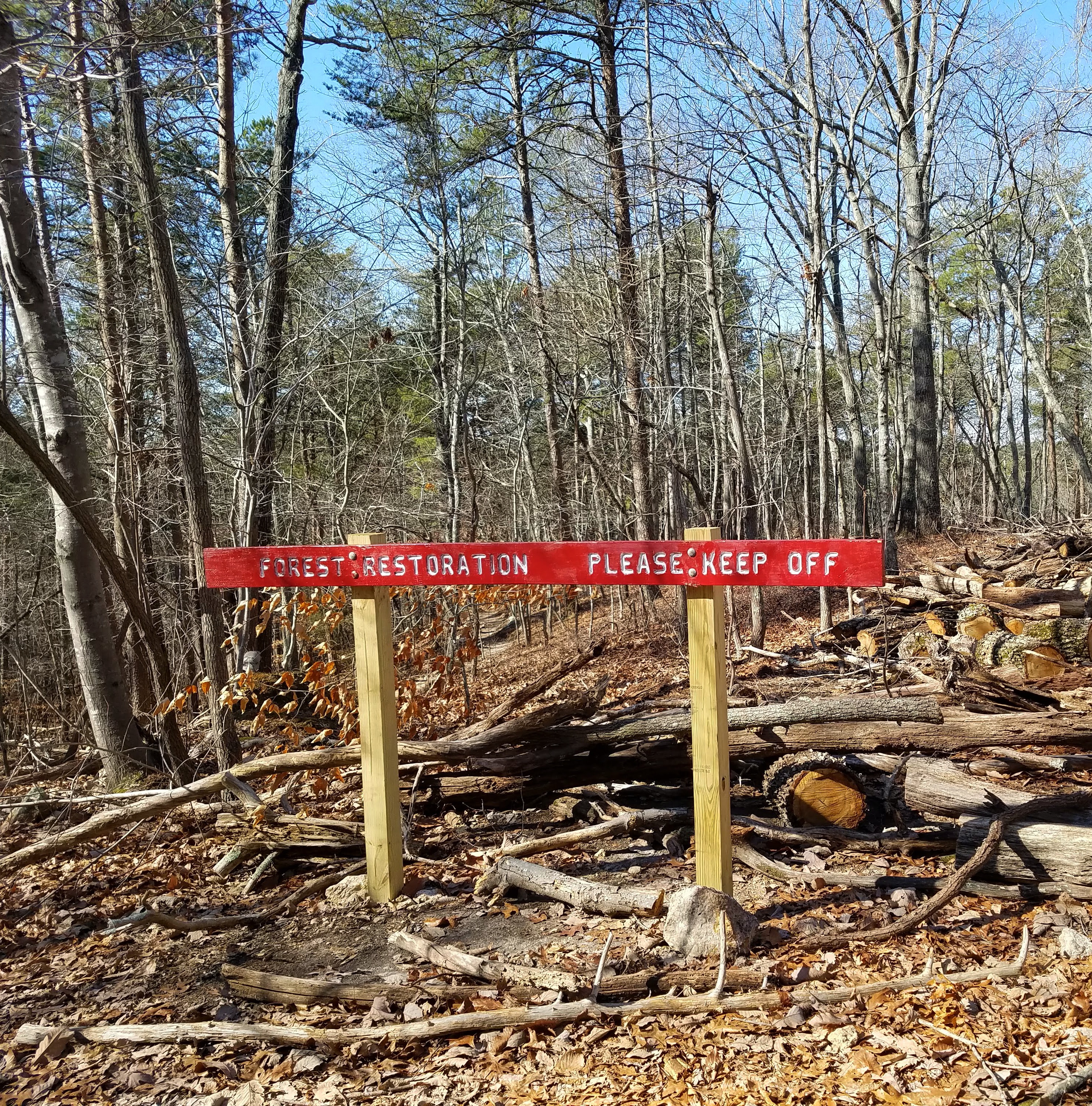
I also passed rock formations as the trail curved away from the interstate, and as I approached a low shoulder I noticed restoration work. A new trail rerouted off the top of the rise and the old trail was filled in with chopped up tree trunks and limbs to deter future use. Great trail work and kudos to a job well done to keep people on the new trail.

I followed the trail as it descended to the river’s edge, where I encountered a side trail to the left and a sign saying the state park ends there and private property begins. [My GAIA app indicated this place is called “Jumping Rock.”] Being respectful of private property, I stayed on the main trail and walked for a ways alongside the reflective still waters of the Eno.

Not showing on the map, but signed as plain as day, is a short side trail to the site of pre-Civil War Occoneechee Quarry (abandoned around 1908) which I took as an invitation to take a look. Slippery remnants of snow and ice held on in deep shadows at the quarry’s base. I passed three teenagers coming out from the quarry…hmmm…

Occoneechee Mountain rises sharply from the river’s edge, and the trail turned and suddenly took me up recently constructed sturdy steep stairs and barely recognizable steps in dire need of replacement.

I turned right onto the Overlook Trail that leads to the top edge of the quarry and a fine view of the Eno River below.

A grown man having fun with his remote control truck

At this point I had decisions to make: backtrack to the Loop Trail or find another way back to the parking area? The trail completer in me took over and said, “Why not hike a loop-within-a-loop?” I’ll spare you the turn-by-turn, but I managed to complete the entire Loop Trail plus a few others for good measure.

One of two fishing ponds on the southeastern side of the Loop Trail

Occoneechee Mountain State Natural Area is a wonderful resource for locals and an easy diversion for travelers, a few miles of real dirt trails in urban-suburban sprawl. I’m very glad I finally took the exit!

I’m sorry to say that the North Carolina State Parks website is lacking in information about the human history of Occoneechee Mountain SNA.  Read this Eno River Association web page to learn more about its history since Europeans came to the area and recent preservation efforts, but also go further back in time here and here to learn about the Occaneechi indigenous peoples that preceded them. A land acknowledgement of the Occaneechi band of the Saponi Nation can be found here.

“In every walk with nature one receives
 far more than he seeks.”
  ~John Muir


Thursday, November 3, 2022

Big Bend National Park: Lost Mine Trail & More Cowbell

Big Bend National Park: Lost Mine Trail, Window View Trail
 & More Cowbell (I Mean Terlingua)
 1/17/22 – 5.2 Miles

Emory Peak, Toll Mountain and Casa Grande Peak (L/R)

Groundhog Day: the long drive from Alpine to Big Bend NP again. This was our last day in this jewel of a park and we’re actually going hiking before we go home. We headed to Chisos Basin, the center of it all - a pile of mountains in the middle of surrounding flat desert - the highest peaks and the biggest views.

Emory Peak, the highest point, is 7,825 feet…but we’re not going up there. The shortest out-and-back trip to its summit is more than 10 miles. Rather than spend a whole day on one trail, we tackled a half-day hike in the neighborhood: Lost Mine Trail.

My mantra en route to trailheads and campgrounds: Please let there be an open space, please let there be an open space, please…

Lost Mine Trail is the most popular hike in Big Bend NP and there is limited trailhead parking. If it’s full, the alternatives are parking at Chisos Basin Visitor Center and walking the twisty-turny paved road back to the trailhead…or choose another hike. Perhaps we were in between the morning and afternoon waves on this Monday morning of Martin Luther King weekend. We got the last parking spot.

Trailhead sign and a reminder of who lives here

The name “Lost Mine Trail” can be misconstrued as climbing up Lost Mine Peak itself,
 but it actually climbs a ridge to a viewpoint of Lost Mine Peak to the east
 and Casa Grande Peak to the west

As we’ve learned to expect, we had a chilly start. There were not too many people on the trail, at least not by Great Smoky Mountains standards. The path was rocky, dusty and worn, but holding up well for the years since it was built by the Civilian Conservation Corps (CCC) in the early 1940’s.

We started out in an oak and pinyon pine forest with glimpses of what’s ahead

The trail climbs gradually along the base of Casa Grande Peak. About one mile in, it reaches a saddle where the view busts wide open.

Casa Grande Peak, totally dominating like a fortress on a mountaintop

Casa Grande Peak and its sidekick Toll Mountain

Looking south into Juniper Canyon and beyond

After reattaching our dropped jaws, we continued on as the trail turned left away from the peak views to climb long switchbacks to the ridge (quad workout!)

Check out the CCC stonework on the right edge

Changing perspective, looking northwest at Mount Huffman in the center,
Casa Grande on the left

The last few switchbacks were steep, rocky and exposed, requiring full attention on your feet unless you stand still to check the view, which I did about every ten steps. 

The last half-mile was a mostly level walk along the ridge (also exposed with steep drop-offs)

Trail’s end is a pile of house-sized boulders to climb around on for vantage points looking west across Juniper Canyon at Casa Grande Peak and Toll Mountain, and south to Mexico. To me, the Chisos Mountains resembled the Grand Tetons without snow.

Looking south, an unnamed rock pinnacle in the foreground, Elephant Tusk sticking up
 like a tooth on the middle horizon, Mexico on the far horizon

Disclaimer: I didn’t have a reference point for Lost Mine Peak but this is a photo looking
 in that direction from the ridge

We ate lunch sitting out on the rocks, chatting with a man who was very knowledgeable about the park. He lives in Virginia but had visited Big Bend a dozen times, feeling drawn to the vast, mystical, unknowable landscape.

As the afternoon swarm of peeps arrived, we retraced our steps. The air had warmed up and the hike back seemed to take longer than expected. As I walked I wondered, as I often do when exploring the natural wonders of this country, whether I would ever return to this trail. Felt grateful for this adventure with my family on a beautiful clear day.

At Chisos Basin Visitor Center we changed clothes and indulged in ice cream. Asked about visitation numbers, the ranger keeping count of folks coming in the door told us it was a slow week. Between Christmas and New Year’s they saw around 2,300 people per day, while today Laura was number 138. I was a bit surprised since this was a holiday weekend in cooler temperatures.

From the VC, we walked the quarter-mile Window View Trail, a nice way to wind down and change gears. So far, everyone else had seen a roadrunner except for me, and then one appeared in the parking lot!

We hadn’t had enough of Terlingua, so we drove west from Chisos Basin as we waved goodbye to Big Bend National Park. After a beer on the rooftop deck at High Sierra Bar & Grill, we took a walk around the ghost town’s self-guided tour of old buildings, some intact and some piles of rubble. I felt appreciation for the grit required to live through the town’s hey-day of mercury mining and later decline. Read more about Terlingua’s history here. Google will give you gobs of information about what to do there.

The most intriguing place in this scrappy town is the Terlingua Cemetery, at first glance a small collection of rough graves that deserves a closer look. It’s on the National Register of Historic Places.

Graves are arranged somewhat in row formation, covered by stones and dust and dirt, most facing east. Some are decorated poignantly with flowers, candles, coins and personal items. Some have makeshift crosses. Some are neglected. It seems a sobering place to be laid to rest, yet there is a sense of community and levity here. The cemetery has a following as a spiritual site.

Epitaph: "Not all who wander are lost"

Pay a visit, make a toast, leave the container

Some fancy new neighbors

We scratched the surface of this corner of Texas, realizing that it would take a lifetime to explore it all (don’t forget Big Bend State Park right beside it). Everything we packed into three days was worthwhile and we’ll count down the days until we can return.

“If a man’s from Texas, he’ll tell you.
 If he’s not, why embarrass him by asking?”
 ~John Gunther