Thursday, April 30, 2015

Foothills Trail Thru-Hike - Oconee Bells & Heartbreak Ridge


Foothills Trail Thru-Hike – Day 3 - 3/25/15 – Thompson River Campsite to Rock Creek Campsite – 15.6 Miles


This morning our tents and groundcloths were bone dry.  Good omen?  One of my hiking poles (which double as tent poles) wouldn’t lock and I spent 15 maddening minutes fiddling with it, finally taking it apart and working with the screw inside.  Bad omen?  Charles left out a bit ahead of us, maybe we’ll see him at the end of the day.  The trail headed uphill right from camp so we started out in shorts and short sleeves.

Cathy is a waterfall fan and has hiked around the Foothills area a bit, but on today’s section we took the short side trail to a new one for her (they are all new to me). 

Hilliard Falls, named for Glenn Hilliard, first chairman of the Foothills Trail Conference.  Great swimming hole for a warmer day than today.

We backtracked the .2 miles to the FT.  While standing by the Hilliard Falls sign, we felt tiny raindrops and put on our pack covers – 9:15 a.m.  The drops soon became steady rain and we slipped into our rain jackets.  Rain jackets are hot, so either you are wet from sweating or wet from the rain.  Sitting down to eat breakfast wasn’t appealing and we kept hiking, hoping for the rain to slow down, but we finally had to stand still and choke down a few bites.  This is the character-building part of backpacking!  The rain really isn’t so bad if you embrace it and keep on walking.

Even when it rains for 4 hours as the trail winds in and out of the dripping forest onto old logging roads and there are few flowers or views or points of interest

Okay, one sweet Robin’s plantain

Interesting bark on a tree blocking the trail

The rain relented, although the sky remained overcast.  Focused in my own little hiking zone, I rounded a curve and came upon…people!  Lots of them!  A crew of students from Auburn University out for a spring break adventure.  They were moving slow, as large groups tend to do, taking about 10 days to hike the FT as compared to our 5 days. 

I thought the group was pausing to descend steps down to the bridge over the Horsepasture River (come on, get outta my way, I’ve got miles to go) and then one of the guys pointed down.  Along the sides of the trail and all down the mountainside, intertwined in ivy, were Oconee Bells, millions of them.  The natural range of Oconee Bells is the river gorges that feed Lake Jocassee, meaning they are rare except when they are blooming in profusion from mid-March to early April.  Our timing was perfect. 

Floral explosion

Along the staircase (not a good photo but you get the idea)

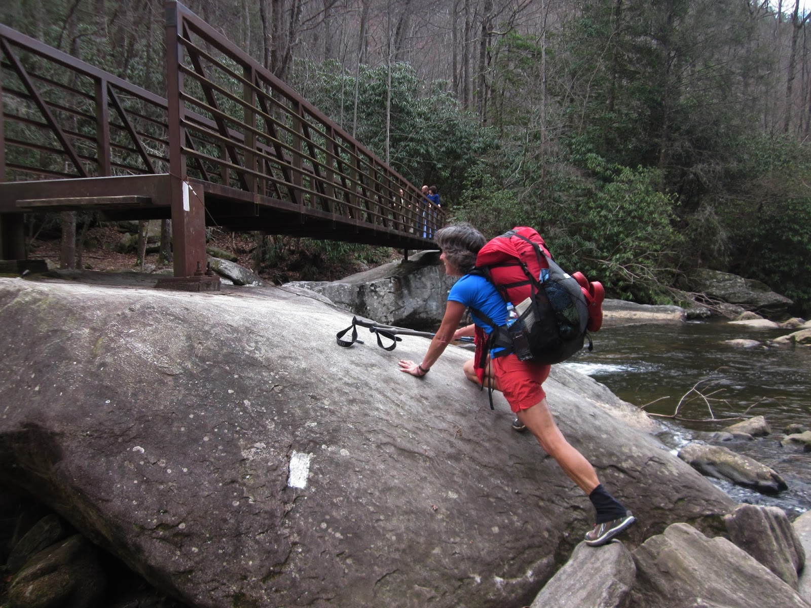
A calm section of Horsepasture River flowing under the bridge

Cathy’s photo of me after crossing the bridge and beginning to ascend stairs on the far side

More weaving off and onto logging roads.  Several times the trail veered off into the woods, paralleling in sight of the dirt road, then dumped onto it for a hundred yards, then off into the woods again.  The one time I made a misstep was where the trail actually crossed the road but I turned onto it.  I quickly realized my mistake and retraced my steps. 

Note to future hikers:  Do not confuse Bearcamp Creek with Bear Creek.  They are about 5 miles apart on the trail and both have designated campsites.   Both are crossed via 35-foot wooden bridges.  Make sure you are where you think you are.  Just sayin’.

“Wherever you go, there you are.”  Helpful trail signage.

The FT winds along the shoreline of Lake Jocassee for about 1.5 miles and we could see where the Toxaway River pours into the lake.  We crossed the river on the longest suspension bridge on the FT.

After Toxaway the Foothills Trail Guide warns in bold letters with flashing lights that a VERY STRENUOUS section called Heartbreak Ridge is coming up:  hundreds of wooden steps ascend and descend the ridge and great caution is required.  The previous night Cathy and Charles and I had discussed this and planned to camp at the designated area right after this epic section because we would be, you know, exhausted. 

Turns out Heartbreak Ridge wasn’t a big deal, maybe because it was anticipated – 286 unevenly spaced wooden steps up and who knows how many more down - but I walked very slowly, counting as I went.  I looked back and thought, “That’s it?”  I think that people believe they have to quickly power through steep sections, when the real trick is to slow w-a-a-a-y down.

We descended and crossed the suspension bridge over Rock Creek and arrived at the agreed-upon campsite, a huge space alongside Rock Creek.  It was 4:40 p.m. and we had hiked 15.6 miles.  Cathy had seen Charles continue on.  Tough choice - do we keep going?   My legs had a couple more miles in them, but the next campsite was over another climb and 4.5 miles away.  We decided to stay put.

Camping at Rock Creek

Having so much time to set up camp was nice, time to relax, hang up stuff to dry, enjoy a leisurely supper.  About 7:30 p.m. (the time we would have been just arriving at the next campsite) the rain began to pitter-patter again. 


“Smile, breathe and go slowly.”  ~Thich Nhat Hanh


Monday, April 20, 2015

Foothills Trail Thru-Hike - Upper Whitewater Falls


Foothills Trail Thru-Hike – Day 2 - 3/24/15 – Chattooga River Campsite to Thompson River Campsite – 19.7 Miles


Cathy and I are simple morning people, no stoves, no cooking, just grab a nutrition bar and hit the trail.  Our tents were just slightly damp.  We packed up and were on the move about 8:00 a.m., a bit chilly in long pants and gloves. 

After two short miles we reached Burrell’s Ford Road. Nearby is a USFS camp- ground.  We couldn’t have made it there last night to camp in comfort, but we were still excited for the composting toilet in the parking lot.  Here we removed clothes down to shorts and short sleeves for our upcoming climb.

On the climb up Medlin Mountain we saw a tree burl as big as Cathy

Watch your head

Our guidebook indicated winter views of Whiteside Mountain but I must not have looked at the right time and missed it.  We did have nice glimpses of Lake Jocassee.  Benches along this section were built by a Girl Scout and several bridges were built by Boy Scouts. 

Emerging yellow trillium

More trillium foliage – what kind will this be?

Today we crossed the state line into North Carolina.  I was especially excited because Upper Whitewater Falls was the star attraction coming up.  We detoured to the restrooms for fresh water and walked through the huge parking lot to the falls overlook.

Upper Whitewater Falls, 411 feet high and pretty impressive even across the gorge

The side trail scrambles steeply down to connect with the Foothills Trail which leads to a massive steel bridge across the Whitewater River.  The signage tells you that you can’t view the falls from the river, but you sorta can glimpse it without the foliage if you know where to look. 

Cathy stretching to get onto the bridge - sometimes being short has its disadvantages

On the bridge over the Whitewater River

Yellow violets at the base of a stump

The miles seemed to pass more easily today, although the elevation map would say otherwise.  Camping is not allowed for several miles in the Whitewater River area, so we had more hiking ahead of us.  We finally called it a day as we crossed Thompson River on a 75-foot wooden bridge to a designated campsite.  Here we pitched tents along with Charles, the fellow who shuttled to the trailhead with us the day before. 

We carried our cooking gear down to big boulders beside the roaring creek and enjoyed a relaxing supper after a high mileage day, comparing notes about hikes completed and trails yet to be traveled.  My feet and legs weren’t quite as tired tonight.  Lights out by 8:30 p.m.

“Those who contemplate the beauty of the earth find reserves of strength that will endure as long as life lasts.”  ~Rachel Carson


Thursday, April 16, 2015

Foothills Trail Thru-Hike - Chattooga River


Foothills Trail Thru-Hike – Day 1 - 3/23/15 – Oconee State Park to Chattooga River Campsite – 14.4 Miles

The AT, the PCT, the CDT, the triple crown of long distance hiking trails in the U.S. on which many weekend-warrior hikers dream about quitting their day jobs and finding themselves. But there are multi-day trails in my backyard that can challenge skills and offer that I'm-going-into-the-woods-and-not-coming-back feeling too, such as the Bartram Trail and the Foothills Trail.


The genesis of a thru-hike of the Foothills Trail came as an invitation from a long distance hiker friend and her long distance hiker friend who I had not previously met.  I was thrilled to jump on board with experienced folks for my longest backpacking adventure to date.  However, the original plan for February was abandoned due to a daunting weather forecast of extreme cold.  The next window of opportunity in late March was again canceled due to illness and work responsibilities of the other two hikers…

But I had taken time off from work, upgraded some equipment, prepared food and was ready to go.  What to do, what to do?  Go somewhere more familiar for a few days (hello Smokies!) or try the thru-hike on my own?  Jim encouraged me to try the solo.  Then I floated the idea to my friend Cathy, and with 3 days’ notice she cleared her schedule and off we went. 

Basics on the Foothills Trail:  Located in the mountains of upstate South Carolina (yes, they have great mountains), the hiking-only trail stretches between Table Rock State Park and Oconee State Park, including a few miles across the border in North Carolina’s Gorges State Park.  The reasons to hike the Foothills Trail include water, water, water features:  the Chattooga, Whitewater, Thompson, Horsepasture and Toxaway Rivers, Rock Creek, Laurel Fork Creek, Lake Jocasee and numerous waterfalls and cascades.  If you like camping by water, this trail is waiting for you!  Blazes are plentiful and easy to follow (2x6-inch white rectangles).  The Foothills Trail Conference website is fantastic and the maps and guidebook have about everything you need.  Only problem:  the guidebook is written from Table Rock to Oconee, and we hiked in the opposite direction.  I am terrible at interpreting narratives backwards. 

We compressed the hike plan to 5 days and 4 nights - again, the longest fully loaded backpacking trip I have attempted and now it is also high-mileage - and as usual I burned brain cells obsessing about food, water, gear and pack weight.  My final pack weigh-in was 28 pounds and I felt every ounce of it. 

On a pleasant Monday morning while the rest of the world was at work, we met our shuttle driver at Table Rock State Park, along with another hiker from Florida who had the same general plan, and before you could say “where’s the buffet?” we were standing at the trailhead at Oconee SP.   

With Cathy’s old map and my backwards guidebook, we crossed our fingers and got going.  (No worries, we discovered that the trail was so well marked that there was little chance of getting off of it, and frequent signage at major intersections even told us how many miles between the two parks and anywhere else.)

A gentle, soft start on pine needles gave us confidence for our long adventure.  (We knew the steep climbs were waiting at the other end on Thursday and Friday.)  Walking in and out of the contours of Long Mountain and Dodge Mountain, I noticed remnants of a forest fire.  New growth sprouted from the bases of blackened mountain laurel.  I was shocked to read in the guidebook that the Jumping Branch fire occurred in 1978 – 37 years ago! 

At the Nicholson Ford access parking area we spotted this funmobile.  How far into the woods did the owners go?   (Answer:  about half a mile to the first big campsite)

Footbridges galore, nary a wet crossing on the entire Foothills Trail

Licklog Falls (where we crossed paths with more party people)

We were a little early for spring flowers except for these sweet tiny yellow violets.  We were on the lookout for Oconee bells, a rare flower found only in the southern Appalachian Mountains, concentrated in the tri-state border region of Georgia, North Carolina, and South Carolina. 

The infamous Chattooga River that played a starring role in the movie "Deliverance" in real life is the natural border between South Carolina and Georgia.  The FT walks within the sight and/or sound of this designated Wild and Scenic river for several miles, sometimes right alongside it and other times teasing with glimpses of cascades and waterfalls.

In two places along this part of the Chattooga there is a low water route where hikers can have a toe dip or a high water route to avoid going in neck deep.  Fortunately for us, the water was low enough to get up close and personal.

Finding a riverside campsite by reading the guidebook backwards isn’t so easy.  Is this the one they mean? Doesn’t look like much.  Is this the one they mean?   Not flat at all.  Is this… We kept going just a little bit further, even as our ankles and feet begged for mercy after miles with heavy packs.  We chose the last site on the river (although we didn’t know that until the following morning).

Cooking supper by the riverside

When two people go backpacking, each should be self-supporting, i.e. carrying one of everything necessary such as stoves, water filters, headlamps, etc.  In a group of 3 or more, two of everything can still be sufficient.  On this trip I carried Aqua Mira water treatment drops and Cathy carried her Sawyer Squeeze filter.  We discovered on this first night that Cathy’s filter wasn’t working properly, so my water drops became the default for water purification.  (Later on in the trip I had a stove igniter malfunction and was glad for Cathy’s Jet Boil.)  Lack of ability to purify water is a sure way to cut short a trip and a reminder to me that water treatment drops always work (as does boiling water, but then if your stove doesn’t work…)

My tent site wasn’t so level at this spot either and I rolled sideways downhill all night, but I was oh-so-glad to be lying down.  Before I closed my eyes, I inspected my feet and applied magic duct tape to a couple of red areas, hoping to ward off blisters ahead.  Not quite 15 miles today and tomorrow will be longer… and that pack sure is heavy… but the woods and water are so beautiful…

“And so each adventure is a new beginning.”  ~T.S. Eliot