Showing posts with label Roan Mountain. Show all posts

Tuesday, June 19, 2018

AT in TN: Roan Highlands Ramble


AT in TN – Roan Highlands Ramble – 6/17/17 – 6 Miles

My training for our AT hiking in Maine next month was behind schedule when a friend told me about her own plans to hike on an upcoming trip to England.  Where’s a good local trek with great views to keep you motivated?  Well, I know just the place (not local) but...it’s a long drive there and a long drive back, but you’ll be so glad you made the trip!  Trish, her sister-in-law D’Lane, and I made a day of it.

June is a popular month at Roan Mountain, when the azaleas and rhododendrons bloom profusely at every turn – in fact, the day we chose was the town’s annual Rhododendron Festival and traffic was bumper to bumper.  After that slowdown we were definitely ready to get our legs moving.

The Appalachian Trail crosses the road at Carver’s Gap and heads northbound across grassy wildflower-covered fields and over the summits of Round Bald and Jane Bald. Then a teensy side detour to Grassy Ridge Bald is the third summit in this triple crown.  Our out-and-back hike started in sunshine, then we watched storm clouds gather, felt the wind pick up and blow the clouds through the gap, depositing a misty rain, and then the sun shone once again.  Some folks might have been uncomfortable being exposed to all that, but my trooper friends appreciated the front row seat to Mother Nature.  What a grand show!    Photos below, no captions needed.


“Climb the mountains and get their good tidings. Nature’s peace will flow into you as sunshine flows into trees. The winds will blow their own freshness into you, and the storms their energy, while cares drop off like autumn leaves.”  ~John Muir

Sunday, June 19, 2016

AT in TN: Iron Mountain Gap to Carver's Gap - Roan Mountain


Appalachian Trail in TN – 2/29/16 – Iron Mountain Gap to Carver’s Gap – 15.2 miles


During the winter of 2014 I worked on my goal of completing the Virginia section of the AT.  Week after week, my efforts were thwarted by frequent heavy snowfalls and colder than usual temperatures.  Many of my hikes are solo and I take seriously the consequences of an injury in any circumstance, but an injury out alone in the cold is more than I am willing to risk, so the conditions under which I go winter hiking are zero to very little chance of precip and no wind.  More than once in the winter of 2014 I arranged shuttles for dayhikes, only to have the shuttle driver advise me the day before that it might not be safe. 

Not true in this winter of 2016.  Trailheads have been accessible and trail conditions have been tolerable.  Given all that, today’s hike still took me a little bit by surprise high up on Roan Mountain. 

My shuttle driver and I met at Carver’s Gap on Highway 261 just a smidge over the state line in Tennessee.  Carver’s Gap is the jumping off point for roaming around the Roan Highlands, a favorite section of the AT for its high elevation, grassy balds, rhododendron bloom and Sound Of Music vistas.  From there we drove south and she dropped me at Iron Mountain Gap.  I faced 15.2 miles on a chilly but clear winter day with lots of waypoints to keep me entertained on my walk back to Carver’s Gap.

And traces of snow

Notice that “Greesy Creek Gap” has been written in by hand on the trail sign (with creative spelling).  Four miles into my hike I stopped at this gap to eat and saw another hand lettered sign indicating a hostel .6 miles down a side trail.  I met a hiker at the gap who told me the story of a dispute between landowners.  A woman bought a piece of property and created a hiker hostel, but her neighbor did not appreciate the endeavor and began a campaign to make life difficult, mowing the lawn at 6:00 a.m., blocking the driveway, etc., and possibly defacing the sign to remove the name of Greasy Creek Gap.  How much of that is true?  Be sure to read my next blog post.


The trail featured plenty of small ups and downs and intriguing trees.  How does this one stay standing?

Winter sky

I couldn’t tell whether this was a trail maintenance marking or graffiti

The reward for the steep push up Little Rock Knob was a sweeping view into a valley with a Christmas tree farm

And a little more snow

Monument at Hughes Gap

I was 9 miles into my hike and feeling a teensy bit fatigued.  Looking at the elevation profile ahead did not help.  Right in front of me was an intimidating relentless climb up Roan Mountain, 2,245 feet in less than 4 miles.  One foot in front of the other.

The snow got a little deeper, and a little deeper, covering the rocks and roots so that every step needed to be intentional.  My criteria of no precip and no wind was in effect, but I hadn’t expected the amount of snow and definitely did not want to slip and sprain an ankle or break a leg.  I hadn’t seen another hiker since the fellow at Greasy Creek Gap and there weren’t going to be any buses coming by.  I concentrated, taking short steps with my tongue hanging out, and my pace slowed to about one mile per hour.  Whew.

I took just one photo during my ascent, icicles on a cold day.  Near the top, balsam and Fraser firs appeared and transformed the woods into magic land. As the trail continues north, this is the last large area of fir and spruce before reaching New England, other than one small section on Mount Rogers in southwest Virginia and another in Shenandoah National Park. Sound was muffled by the snow and I kept my eyes peeled for tiny tracks and woodland creatures.

Just past the summit of Roan Mountain is Toll House Gap.  Back in the 1880’s General John Wilder took an interest in the beauty of the views and the profusion of rhododendron and built the Cloudland Hotel so all the wealthy folks could enjoy it in comfort.  The hotel operated for about 20 years before being dismantled in 1914 and returning the mountaintop to nature – almost.  Today there is parking, a picnic area, restrooms, boardwalks and viewing stands. 

From the meadow at the Cloudland Hotel site you can see Table Rock and Hawksbill at Linville Gorge and Grandfather Mountain.

Too early to celebrate – there is still a half-mile to Roan High Knob Shelter (more uphill in the snow).  Yes, I skipped the slight side trail to the shelter.  Don’t judge.

The rocky trail (old Hack Line Road) from Roan High Knob down to Carver’s Gap was blanketed in several inches of snow, giving the switchbacked descent a dreamy snowshoe-like quality.  I met one local fellow going up to the top, said during the winter snows he frequently hikes a loop going up the trail and down via the road.  I envied his proximity to this place in all seasons.

The trail turned right off of the wide track and zigzagged through the open forest, crossing several footbridges before connecting to the parking lot at Carver’s Gap.  It was later than I had anticipated finishing the hike and I had a three-hour drive home. All in all, a challenging, invigorating, soulful day in the woods.  


"Only when you drink from the river of silence, shall you indeed sing. And when you have reached the mountain top, then you shall begin to climb..." Kahlil Gibran

Thursday, July 16, 2009

Roan Mountain and More SB6K's

Roan Mountain – 6/7/09 – Appalachian Trail – 10 miles

This morning I woke thinking that another 24 hours of sleep would be great. BUT I was scheduled to hike with the Carolina Mountain Club, including Danny and Lenny, in the Roan Mountains. I was very much looking forward to seeing the Roans, but I sure didn’t want another fast hiking day.

Not to worry – I give two thumbs way up to the CMC group for a delightful day! The drive to the trailhead was long, but I was neither driver nor navigator so no effort on my part. The group assembled at the Carvers Gap parking area was varied and included four who had not hiked with CMC before – myself, a woman from Shelby, and a father-and-young-adult-son team from the Midwest who were traveling on their way to the beach and wanted to do something in celebration of National Trails Day. (CMC's hikes are show-and-go, not sign-up in advance.) Our hike leader had everyone sign in and give an emergency contact number, then reviewed the hike plan. He went over the guidelines of a lead and a sweep and that they would wait at junctions for the group to reassemble as a whole. Pinch me! I was thrilled.
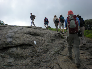
My husband and son had been to Roan Mountain back in their Boy Scout days but this was my first experience there. Yesterday’s hike in Shining Rock Wilderness gave me a taste of mountain balds and this hike was similar. The Roans are well-known for their rhododendrons but we were a little early for peak blooming (mental note: third week of June is best). Today we headed north on the AT. The hiking pace was leisurely, not too slow, certainly not too fast, and we frequently stopped to identify anything blooming (someone was keeping count of how many different species could be found.) We went up and over Round Bald, down Engine Gap, and then over Jane Bald. The day was spectacular and I was having fun now!

We took a right turn up off of the AT to our first destination of the day, Grassy Ridge Bald, one of the SB6K peaks. As of today it is official – did any of you doubt it? – I am working on the SB6K Challenge. In the interest of my sanity I am not putting a time limit on this challenge, though. I am simply looking forward to exploring many different areas in the Southern Appalachians as I work toward this goal. And it will take me back to the Smokies! I summitted the SB6K’s that were directly on trails there, but some are off-trail and I passed them by.

Here is Lenny pointing out something of vital importance – not sure what! I have some great photos of Lenny.

From Grassy Ridge we backtracked a bit and chose a lunch spot. Some people sat together while others took the opportunity to sit alone and chill in a front row seat for this special place. This woman enjoyed her apple and then pulled out a book to read. I would have loved a nap, but it’s hard to appreciate the view with your eyes closed!

Our backtracking continued nearly all the way to the parking area, and we crossed the road to continue south on the AT, climbing steadily on switchbacks up to Roan High Knob, our second SB6K of the day. Here we explored the shelter, which at 6,285 feet is the highest shelter on the entire AT. It is two stories and sleeps 16 friendly hikers. Here is a lovely photograph of the shelter in snow and further description. (BTW, this website, Appalachian Treks, is one of my favorites. He posts photos nearly every day with a short quote, story or Bible verse. A great way to start the day.)

 The true summit of Roan High Knob is atop a rock outcropping a short distance from the shelter. This benchmark is embedded in the rock. Here’s a hint if you decide to become an SB6K enthusiast yourself: the placement of the benchmark is not always the very highest point. Look around and see if there is anything higher than where you are standing (or check your GPS). Of course you are on the honor system anyway, but I’d hate for you to miss the summit by a few feet.

Most of the group planned to backtrack to the parking lot from this point, but Danny and Lenny had worked out a plan to continue on to summit the third SB6K at Roan High Bluff. Five of us pressed on and drivers from the return bunch offered to retrieve us and return us to our cars. (In the end, the returners hiked more mileage than we did!) Our route took us past the former location of the Cloudland Hotel, once a luxury hotel that straddled the NC-TN state line. Appalachian Treks has a humorous summary about the demarcation line. We followed the Cloudland Trail out to the Bluff Overlook, a wooden platform constructed to keep people from throwing themselves off the edge. There are several parking areas up near this end of the trail for easy access to the overlook, i.e., we were not alone. Adults, kids, dogs – everyone was enjoying the day.

I most thoroughly enjoyed hiking with the CMC group. Staying together afforded the opportunity to talk with everyone and I learned some new flowers and the opportunity for more hikes, including a backpack trip that the group makes every year to do the more difficult off-trail SB6K’s in the Smokies – yay! This was just the hike I needed today.

Our trail angels delivered us back to our cars and we began the long drive to Asheville. We decided that sushi was called for, and we stopped at the Bernsteins’ home so I could retrieve my car.

Well, no day is perfect – my battery was dead and we had some fun resurrecting it. After a delicious meal and goodbyes, I popped in my favorite CD’s and went on auto-pilot to Charlotte, arriving late but happy. Two big goals in one weekend – Cold Mountain and Roan Mountain! And I’m still alive! My list of destinations is growing longer…

 Congratulations! Today is your day. You're off to Great Places! You're off and away! You have brains in your head. You have feet in your shoes You can steer yourself any direction you choose. You're on your own. And you know what you know. And YOU are the guy who'll decide where to go... So...be your name Buxbaum or Bixby or Bray or Mordecai Ali Van Allen O'Shea, you're off to Great Places! Today is your day! Your mountain is waiting. So...get on your way! ~Dr. Suess "Oh, The Places You'll Go"
