Wednesday, December 31, 2014

AT Project in VA: Grand Finale at Dragon's Tooth


AT Project in Virginia – Dragon’s Tooth Grand Finale – 11/7/14 – 14.1 Miles

Cathy and Becky joined me on my final hike on the Appalachian Trail in Virginia.  I saved this section for last because Dragon’s Tooth is an iconic feature of the AT.  Our shuttle Driver, Joe, took us to our starting point at the parking area on VA 620 where my car battery died on mybirthday and we headed northbound. 

The weatherman was wrong again and not in our favor, as a light misty rain followed us for the first couple of hours.  We stayed chilly all day in long pants and gloves.

Side trail to Pickle Branch Shelter.  Apparently thru hikers don’t have a high opinion of it.

Walking through Miller’s Cove, I love the starkness of bare tree trunks and fallen leaves

I was surprised to see this rock wall as the trail ascended Cove Mountain

A little leaf color still hanging around
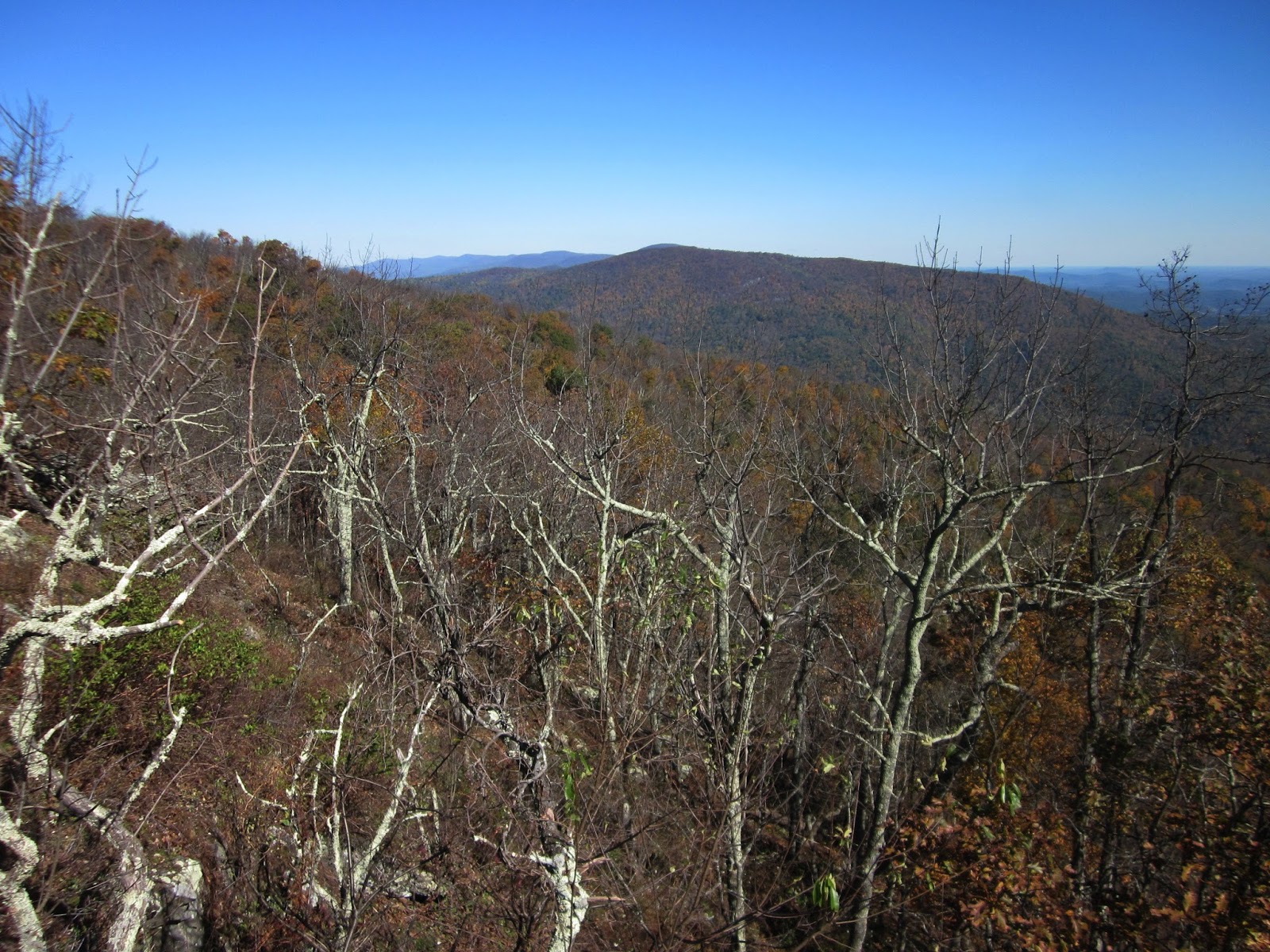
First view today

st leaves were off the trees and piled high on the trail, which looks benign at first but is deceptively dangerous.  We couldn’t see rocks and roots and holes and it was difficult to gauge the depth.  White blazes became essential to follow because we seldom could see the bare trail.  Leaves are also very slippery even when they aren’t wet.  Over the course of the day Cathy and I each fell twice, Becky three times, serious slippin’, slidin’, hurtin’ falls with bruises and small cuts.

Becky:  it’s all fun and games until someone gets hurt

On Cove Mountain, perhaps the strangest bent tree I’ve ever seen

We hiked three miles with no landmarks approaching the top of Cove Mountain, hard to judge our distance.   I could feel myself tanking and we all needed to stop to fuel up.  The wind was brisk and we looked for a protected place out of the wind and hunkered down to eat a late lunch.  Ten minutes later we saw this gorgeous view (but it would have been too windy to eat here anyway).
Looking at North Mountain

Then the highlight of this section:  Dragon’s Tooth, a Silurian sandstone monolith (for you rock people) in a rock outcropping with a broad view of Catawba Valley.  Just a couple of other people there, unlike the crowds on a weekend, but we got our photo taken.  We were lucky to have the place to ourselves for a little while. 

At Dragon’s Tooth

Climbing up (or down?)

Becky was the bravest as she made it to the top…but crawling back down wasn’t easy.  Cathy and I wimped out at that last bit of scrambling.

Cathy, Becky and me at Dragon's Tooth

The AT northbound descending from Dragon’s Tooth was technical in some places, a couple of ladders and some iron handholds driven into the rocks.  This was slow going and again I was glad that there were no other people to work around. 

At Lost Spectacles Gap we passed the side trail to the parking lot access for Dragon's Tooth day trippers.

At Viewpoint Rock

We crossed VA 624 and walked through a series of open pastures and stiles

And wooden bridges over streams

A mile-and-a-half later we crossed VA 785 and faced a crazy steep climb through open pasture and into woods to the top of Catawba Mountain, where we stopped to rest and regroup.  At this point we admitted that distance and time were not in our favor and we would run out of daylight before the end of our hike.  Now the question was:  how long would we hike in the dark?  We all had headlamps…

Along the rocky ridge top locally known as Sawtooth Ridge we followed ups and downs, taking care looking for blazes and picking our way through more deep leaves.  Cathy took another fall and this time it hurt.  As the sun sunk far down below the mountains, the sky glowed a beautiful pink-orange – and then it was dark. 

We didn’t have a good idea of how far we were from the end but hoped it was only a short distance.  Not so.  Becky’s headlamp didn’t work consistently, flashing on and off like a lightning bug, and we all slowed our paces significantly.  Over an hour later, we emerged at our parking lot on VA 311.  No photos, no cheers for the end of my AT project in Virginia.  But I didn’t feel disappointment as much as I felt relief to be out of the woods.

Overall, though, it was a grand day, hiking with good friends, and Dragon’s Tooth is a very special place.  Any day in the woods is a gift.

What next?

“Between every two pine trees there is a door leading to a new way of life.” ~John Muir.


“When the wind blows, you know that somewhere in the mountains it has found the answers you were looking for.  The pull of the horizon overcomes the inertia of reason…and you just have to go.”  ~Vikram Oberoi

Monday, December 29, 2014

AT Project in VA: Goodbye to Shenandoah NP


AT Project in Virginia:  Shenandoah Wrap-Up – 10/19/14 – Smith Roach Gap Southbound to Loft Mountain Campground Store – 12.9 Miles

Lordy, a cold start to the morning!  The wind gusted through the night, bringing on the cold front, and I did not envy Jim riding a bike today.  (In truth he had a leisurely breakfast at the Loft Mountain Wayside while waiting for the day to “warm up.”)  We had a long drive home after our adventures today, so we threw the tent and gear in the car early and got going.


Starting at Smith Roach Gap again (this time heading southbound) I donned all my gear, including gloves, hat and rain jacket, hoping I would soon be taking it all off.  And wouldn’t you know it?  Every other hike of my life has started out with an uphill climb to get the blood flowing…but today it was a gentle downhill around Roundtop Mountain.  The sun was shining, leaves were still crunching, and this was my last day in Shenandoah NP.  Exhilerating!

After crossing Skyline Drive at Powell Gap, the AT climbs the shoulder of Flattop Mountain.  Grand view of Roach River Valley.


Today’s miles felt a little bit like the Roller Coaster section of the AT as it crosses into West Virginia, continuous ups and downs.  From the top of the shoulder of Flattop the trail immediately begins its descent down to Simmons Gap.  There the trail crosses Skyline Drive again and I paused as I recognized this as the point where a year ago our car struck a deer. 

My next climb was Weaver Mountain, no-nonsense switchbacks, and I kept a steady pace.  At the tip-top I heard voices and around the bend came four backpackers in shorts and short sleeves.  As I was registering surprise at their lack of clothing on such a chilly morning, I spotted the very big dog with them (surely a cross between a Saint Bernard and a Great Dane).  The group stopped short at the same moment when they saw me, and the woman in front asked if the dog could approach me – a very different scenario from my encounter with the clueless dayhikers two days ago.  I said yes and the dog very gently came up and licked my hand.  They were gone in a flash.

Down again to Pinefield Gap, then up an unnamed peak (what?  why no name? no more roaches?) and down to Ivy Creek Overlook for expansive views.  I don’t carry my big guidebook with me so I wasn’t able to note the name of the pointy peak, but isn’t it spectacular?


Skyline Drive on the right

Down again into the miniature canyon where Ivy Creek flows.  This was the only noteworthy stream I crossed in three days of hiking.  Lovely.

For the next few miles there were numerous rock outcroppings looking both east and west and I checked out most of them.  I was getting more and more excited as I neared the end of my hike.  At one rock point I said hello to two young backpackers.  I recognized the woman from the previous day because she was wearing bright pink tights.  They introduced themselves as Sockless and Blazer.  Today they were completing their through-hike of the entire AT, meeting their moms at Dundo Picnic Area.  Blazer (the woman) was anticipating an emotional finish and Sockless (the man) was teasing her, although I suspected they would both be overwhelmed when they saw their parents and realized their accomplishment.  How exciting to meet them!  I had a pep in my own step as I continued on to my destination.

Photo taken by Sockless

I was totally unprepared for the wide open space as I crossed Patterson Field and the views to the east.  Just awesome.

Looking east

I arrived at the Loft Mountain Campground store to find Jim waiting for me, but alas, the showers were closed for cleaning.  We changed clothes and waved goodbye to Shenandoah National Park.  I hope to return as a helper for section hiker friends and explore some of the peaks and trails that I passed by. 

Only one thing on my mind as we drove the long way home:  only 14 miles to finish the AT in Virginia and the route includes Dragon’s Tooth.  Who’s going with me and when?

I think the real miracle is not to walk either on water or in thin air, but to walk on earth.” ~Thich Nhat Hanh


Sunday, December 28, 2014

AT Project in VA: Shenandoah NP - Smith Roach Gap to Bootens Gap


AT Project in Virginia:  Shenandoah Wrap-Up – 10/18/14 – Smith Roach Gap to Bootens Gap – 16.2 Miles

The wind increased during the night and we woke with some decisions to make.  Could Jim ride his bike safely/ comfortably?  If not, what would he do while I was hiking?  For that matter, was hiking a good idea with high winds, the potential to be knocked out by falling tree branches?  Ultimately I decided to reverse my hike direction to northbound starting at Smith Roach Gap so that I would be walking towards our campground, and Jim confined his biking range to the middle portion of Skyline Drive, giving both of us more bailout options.  

From Smith Roach Gap (how’s that for a name?) I climbed straight up Hightop Mountain.  At the viewpoint near the top, I stepped up onto a rock for a photo and a wind gust blew me off balance.  I got down off the rock and kept on moving. 


A concrete post sign for a spring

This spring was near the trail and flowing well, something I wouldn’t count on much along the ridge line in Shenandoah.  

A cacophany of audio stimulation, no quiet reflective moments on the trail today.  The brisk wind whipped and bent the trees, and during the rare moments that the trail wound around to the calmer side of a mountain, the rustling leaves and the endless motorcycle drone on Skyline Drive took over the soundtrack.  Leaves were piled high, yet to be packed down by rain and foot traffic.  Every dozen yards or so the carpet colors changed.

Boots and leaves

Boots and leaves – Part 2

Tulip poplar leaf
At Swift Run Gap, U.S. Highway 33 bisects the park and hikers must cross it on the bridge of Skyline Drive.  The trail immediately turns back into the woods and climbs up Saddleback Mountain.  About a quarter mile in from the road I stopped for a snack break and a little shadow selfie. 


A fellow hiker woolly worm

You know I love chicken-of-the-woods bright orange

I was moving along at a fast pace today, keeping an eye on the time and the fact that the wind was increasing in force rather than calming down.  When the trail passed within sight of our campsite at Lewis Mountain Campground, I noticed that our car was parked there.  I assumed that Jim was still out riding on Skyline Drive.  I left a note that I would be at our meeting spot at Bootens Gap about an hour earlier than planned.


From the campground it was an easy 1.5 miles to the trails circumventing and climbing up Bearfence Mountain.  The AT skirts around Bearfence Rocks, so I didn’t try the short but challenging scrambles.  As I rounded the mountain to the side nearest the road, I was very glad that I didn’t try for the summit when I saw the multitudes of people and cars parked every which way.  This is on my must-do list for a future visit, though. 

At Bootens Gap I had just enough time to take off my pack and sit down when Jim arrived.  Traffic was even heavier today and the wind was definitely a factor in his bike riding, but the views from overlooks were so spectacular that he deemed the effort worth it.  We went back to Lewis Mountain Campground.  I had to wait my turn for a quick shower in the less-than-ideal facility (but, hey, it was hot water) and then luxuriated in using my hair dryer in the women’s restroom.  I can be very minimalist when necessary but if the opportunity for pampering presents itself…

As the sun went down the temperature dropped and the wind did not, causing Jim and me to seek warmth and food and comfort at Big Meadows Lodge.  The restaurant wasn’t open yet, so we cozied up in big chairs by the fireplace in the downstairs bar.  Another couple wandered in, football was mentioned, we discovered a six degrees of separation type connection and enjoyed some lively conversation.  They went on their way and we had dinner (good food but late).  There was nothing left to do but crawl back to our campsite with the fierce wind howling, shivering and worrying about trees crushing our tent.  But our sleeping bags were very cozy and earplugs worked well.  Jim didn’t sleep much but I was in dreamland.  Tomorrow is our last day in the Shenandoahs!

Listen to the wind blow
Where does the wind go?
What does the wind know?
Listen to the wind blow