Monday, November 29, 2021

AT in GA: Three Forks to Springer Mountain Summit

Appalachian Trail in GA – Three Forks to Springer Mountain Summit – 10/24/20 – 8.3 Miles

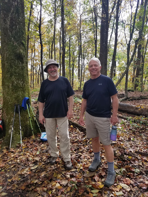
Summit Day! We were up and packed before sunrise, with a few extra minutes for Jim to make his required pour-over coffee by headlamp. He’s a trooper!

Changing up the day’s hike plan meant saving hours of driving to Amicalola Falls State Park. Instead, we drove slowly and cautiously on gravel FR 42, looking for deer in the early morning light, and met shuttle driver Mary where the road crosses the AT. We left our car in the last available legit parking space and she took us back to Three Forks, where we had started northbound yesterday morning.  Today we’re hiking southbound to the top of Springer Mountain.

Bridge at Three Forks

At Three Forks, cars lined the roadside and tents were scattered every which way on this fall Saturday morning. We passed clumps of NOBO section hikers who were still pumped after one day and one night on the trail. Full of anticipation ourselves, we cruised along the gentle three-mile uphill, and Jim was a little bummed that we weren’t going to hike down the Approach Trail too (his ankle seemed a lot better!)

We passed the FR 42 parking area and started the last mile of treads and rock steps placed by trail builders, necessary for heavy foot traffic. I could feel an invisible rope tied to my daypack’s sternum strap, pulling me up to the top. We chuckled under our breath as we passed the still-sleepy stragglers at Springer Mountain Shelter.

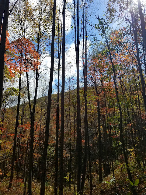
And then we were there at the summit of Springer Mountain, elevation 3,782 feet! Cloudy, no views, half a dozen people hanging out but not crowded – a surreal feeling to be standing at this iconic spot. 


This marks my completion of the AT through GA, NC, TN and VA – about 1,006 miles.
I didn’t know then that nine months later I would jump ahead and summit Mount Katahdin,
the northern terminus of the AT.

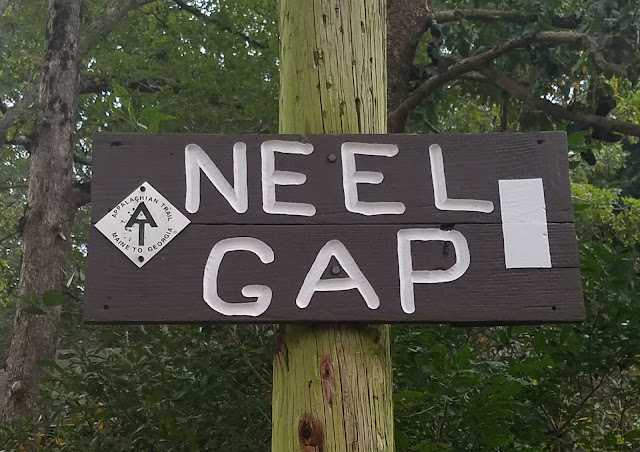
The two of us felt like superheroes now and backtracking a mile to our car seemed anti-climactic so…a quarter-mile from the summit, we took a right turn and stepped onto the Benton MacKaye Trail (BMT).

From this starting point, we followed the BMT for about 4 miles as it wound around Ball Mountain, passed through Big Stamp Gap, then turned west to cross the AT. From there we backtracked a mile to FR 42 where our car awaited. Beyond, the trail continues for nearly 300 miles north through Georgia, Tennessee and North Carolina, ending at Baxter Creek in Great Smoky Mountains National Park. [Learn more about the BMT here.]

,

Before hitting the interstate to get home to Charlotte, Jim and I meandered on Georgia backroads looking for a treat to celebrate our milestone, and we found it at Cooper’s Creek Store in Suches. Fried pies, y’all!

When I finish reading a book, it is my habit to start another book immediately – maybe I just don’t like endings. Walking the first several miles of the BMT got my juices flowing and my thoughts formulating as I recalled a challenging four-day section on this trail in 2018. Now, where did I put those maps?


"Keep close to Nature's heart, yourself,
and break clear away, once in a while, and
climb a mountain or spend a week in the woods. Wash your spirit clean." ~John Muir


Sunday, November 21, 2021

AT in GA: Three Forks to Gooch Gap

Appalachian Trail in GA – Three Forks to Gooch Gap – 10/23/20 – 12.9 Miles

When contemplating finishing the Georgia section of the AT, there’s nobody I’d rather have hiking the final miles up Springer Mountain with me than Jim. I knew there would be payback sometime in the future (cross-country bike ride?) but that give-and-take is what marriage is all about, eh?

So Jim and I drove from Charlotte to Suches, GA on a Friday afternoon. The plan was to base camp at Gooch Gap (where Cathy and I left off a month earlier) and use shuttles to set up dayhikes on Saturday and Sunday. When we arrived at the gap, where the AT crosses FS 42, there were tents scattered all about, so we pitched ours on the “quiet side.” A woman named Maria was taking a zero day and waiting on her partner, John, who was hiking southbound from Neel Gap. Maria built a very nice fire and we hung out chatting with her until John came into camp. He said hello, put one log on the fire, and crashed. 

Jim and I were cozy in our tent by 8:00 pm and enjoyed a peaceful night, not too cold or too hot, just right. Rained from 4:30am until about 6:00 am.

Got up before 7:00 am to prepare for an early shuttle, still dark. I stepped into the woods to pee and saw three spooky figures standing in the hazy daylight on the road by our tent, tall black creepy figures. Trees? Bears? Ghosts?

Three humans having an early morning cigarette break

Our shuttle driver, Mary, picked us up at Gooch Gap right on time and drove us on Forest Road 42 to the day’s starting point at Three Forks. From there we would walk 13 miles northbound back to our campsite.

The trail was shrouded in fog for the first hour or two, but up close the fall foliage was popping. It was one of those color-saturated days that you’re glad cameras are digital and not old-fashioned film that would be used up too quickly. I was continually torn between walking and trying to capture the suggestion of fog through the trees, glistening water drops on leaves, clumps of color floating in mid-air. 

In the first two miles we passed a side trail to the Hickory Flats Cemetery and 
a marker for Hickory Flats School

Anybody home?

Football sized quartz rock

A hardy late season gentian

Handsome hiker

Near Hightower Gap and the intersection of FR 42 & FR 69

Throughout the day we met dayhikers and section hikers going in both directions, some plodding with purpose and others amiable to pause and chat. These two friends meet up annually for
a little weekend section hiking.

Jim developed a sore ankle that continued to worsen throughout the day, especially descending Sassafrass Mountain and Justus Mountain. We mulled over our options for the next day’s hike plan, another 13 miles from Three Forks up to Springer Mountain and down the Approach Trail to Amicalola Falls State Park.

Have you ever noticed the universality of water? Waterfalls, ocean waves, lakeshores, tiny leaves floating down a tiny creek…we humans are captivated by the flow that happens whether we are there or not. The presence of water is always noteworthy along a trail, helping to measure distance and offer respite. Today an unspoken but mandatory break time was declared at Justus Creek, as every two-legged hiker (and one German Shepherd) paused to enjoy the water, whether filling up water bottles, soaking tired feet or laying down in the creek.

Past the creek, we continued on the greatest hits tour of fall colors for another two miles to our campsite. Along the way we crossed paths with Maria and John, wishing them good luck on their journey south.

All was quiet back in Gooch Gap, a few vehicles but no peeps. Jim and I drove out to the Wolf Gap convenience store and bought sodas, chips, beer and cider (yes, they had Austin Eastciders!) [The cashier insisted that alcholic beverages must be placed in plastic bags before leaving the store…hmmmm.] 

We also checked in with Mary-the-shuttle-driver and revised tomorrow’s plan: we’ll skip the Approach Trail section, hike from Three Forks south to the Springer summit, then backtrack to the parking area at Big Stamp Gap. This will save Jim’s ankle, cut short the shuttle, and get us home earlier. Love the flexibility of base camping and shuttles!

At camp we pulled out our tailgate chairs, popped tabs and settled in to watch hikers pass through. Two section hikers, Kevin and Chase, came along and hung their hammocks nearby, and we offered them cold beer – trail magic! They built a low-key fire and we all prepared dinner, talked awhile, and then we left them to enjoy their evening.

Tomorrow is the big day – Springer Mountain!


“Fall, the time when everything bursts
with its last beauty, as if nature had been saving up all year for the grand finale.”

~Lauren DeStefano


Saturday, November 13, 2021

AT in GA: Neel Gap to Gooch Gap

Appalachian Trail in GA – Neel Gap to Gooch Gap – 9/18/20 – 14.5 Miles

Ready for another day in the long green tunnel?

I’ve heard many stories of NOBO thru-hikers slogging the long haul up Blood Mountain, high point of the Georgia section of the Appalachian Trail, in late winter or early spring’s rain and/or snow. With all due respect, I was pretty happy to be dayhiking SOBO with a light pack and fresh legs on a sunny day. Same miles but a different perspective.

Cathy and I left our campsite at Lake Winfield Scott Campground before sunrise to meet our shuttle driver at Gooch Gap, where the AT crosses US Forest Road 42. Today’s hike would be over 14 miles followed by a long drive home.

We picked up where we left off yesterday at Neel Gap, still heading southbound, and moved quickly over the first mile to Flatrock Gap where the Freeman Trail crosses the AT. The Freeman Trail can be used to bypass the summit of Blood Mountain in bad weather. You can combine it with the AT to make a nice loop hike. Flatrock Gap is also where the serious southbound climbing begins. For you data people, the trail gains 1,000 feet in 1.3 miles to the summit. 

Thousands of northbound thru-hikers start at Springer Mountain in GA each year and the majority of them make it to Neel Gap. (About 25% of them get all the way to Mount Katahdin in Maine.) That first 31 miles gets pounded into rocky, rooty, eroded trail that maintainers try heroically to keep in good condition. 

Phlox


Pinesap

Near the top of Blood Mountain

Blood Mountain Shelter was built by the Civilian Conservation Corps (CCC) in the mid-1930’s. It’s made of local stone, two rooms and a fireplace, and sleeps eight comfortably or more if necessary – a welcome shelter on a cold and windy night, but you’ve got to haul your own water from either Neels Gap (SOBO) or the spring at Slaughter Creek (NOBO). 

Be sure to climb around on the big rocks beside the shelter

If you’re planning to spend a night along the AT between Jarrad Gap and Neel Gap – basically all of Blood Mountain – you are required to pack your food in a bear canister. (Please do this so that the bears don’t get habituated to human food.) 

Believe it or not, the next 9 miles flew by. Cathy and I weren’t stopping much, just breathing it in and enjoying our pace. Dayhikers were out in droves, getting their outdoors on during the pandemic. 

On Big Cedar Mountain

Our green euphoria was punctured at Woody Gap where Highway 60 crosses the mountains: motorcycles, radios blaring, trash piled up beside the full trash cans. What is it about people that don’t realize they can take their trash with them? We scampered across the road and back into the woods.


Summit of Ramrock Mountain

Gooch Gap is a prime stop on the AT, about 25 miles from the beginning of the Approach Trail at Amicalola Falls State Park, two days into a thru-hike when the reality sets in. There’s easy accessibility, water, and plenty of tent sites to spread out. I had a moment of confusion before realizing that we had to walk past a lot of tents to reach FS 42 where the trail actually crosses, and made a mental note to base camp here when I return next month to finish my Georgia miles.

Camping, shuttling, and dayhiking is the best scenario for me hiking the AT. I’ll carry a loaded backpack if I have to, but it’s worth the price of a shuttle to carry a light pack and car camp to keep the costs down. And Big Macs are a just reward!

“Hike your own hike!”
~Everybody On the Appalachian Trail