Monday, October 26, 2015

Yellowstone National Park: Fairy Falls, A Grand Prismatic View & A Warm Dry Bed


Yellowstone National Park - 7/27/15 – Fairy Falls/Grand Prismatic Spring/Mammoth Hot Springs – 6 Miles


This morning we broke down our campsite for the last time.  Back in January when we made our Yellowstone plans, we figured that after five nights in a tent we would be ready for cushier accommodations, and we wanted to experience one of the Park’s historic lodges.  Inspired advance planning.

We’d covered a lot of ground in the previous five days and this afternoon we had our eyes set on hiking Bunsen Peak near the north entrance.  This morning was our last chance to enjoy the lower Grand Loop.  Looks like Fairy Falls is a good little walk. 

After a little confusion with the instructions in Hiking Yellowstone (for those of you who care, I think the description narrative incorrectly says Fountain Flats Drive instead of Fountain Freight Road), Jim and I began at the trailhead off of the lower Grand Loop just south of Grand Prismatic Spring.  After crossing the Firehole River on a bridge, we walked for one mile on the wide flat gravel road bed.  We saw a couple of keep-off signs on the mountainside on the left, alongside some obvious trails and even more obvious people scrambling on those trails.  Make a note.

Fireweed

Butter-and-egg

The Fairy Falls Trail was totally flat, passing through lodgepole pine remnants of a devastating 1988 fire…

…and new growth regenerating.  We took a side detour to check out backcountry campsite OD1.

Fairy Falls, 197 feet tall, has carved its niche in the rock.

A closer look at Fairy Falls

On the walk back out, the multitudes were catching up to us.  We scaled the hillside we had noted earlier, suspecting that it gave a bird’s-eye view of Grand Prismatic Spring, part of the Midway Geyser Basin.  The scramble was surprisingly difficult, multiple eroded paths steeper than any trail builder would create, but nevertheless people in flip-flops were making their way up.  I was most concerned that what goes up must come down, and we ended up descending by a different route away from the crowd.  I wonder why the Park doesn’t create a structure to accommodate the hundreds of people who take the risk to see the GPS from that vantage point.

Because you’ve got to admit, it’s a sight worth seeing. The colors are real. (Read about the science behind Grand Prismatic Spring here.)  Click on the photo to see full screen.  WOW.

We backtracked to our car and headed north, stopping in Norris to visit the Museum of the National Park Ranger, a small but fascinating exhibit.  Did you know that Gerald Ford was a seasonal park ranger in Yellowstone in 1936?  One of his assignments was as an armed guard on the bear-feeding truck. 

I enjoyed a long chat with the young seasonal ranger on duty, asked him if he goes backpacking in the Park (he does).  I mentioned that I had seen a hiker carrying a firearm.  The ranger had a lot to say on the subject, primarily that the Park puts forth a great effort to educate about bear activity and the use of bear spray.  Even though firearms are legal, if a person shoots a bear in self-defense, he/she will still be fined because he/she had been advised to use bear spray to deter rather than wound or kill the animal.  The ranger doesn’t carry a firearm for those reasons and because they are too heavy to be practical. And to quote the ranger:  “A gun is not going to stop 800 pounds of pissed off running at you anyway.”  When visitors ask him about the subject, he engages them to find out what their safety concerns really are and encourages them to carry bear spray. 

Continuing north on the Grand Loop, we lost some time caught in major road construction.  Meanwhile, the winds picked up and the clouds rolled in.  We realized that hiking above tree line to Bunsen Peak wasn’t going to work out, and once again we shifted focus, this time to the thermal features at Mammoth Hot Springs.  

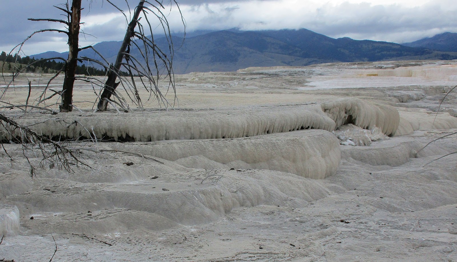
We walked the 2-mile Upper Terraces Road and took lots of pictures that fail to convey the other-world strangeness of the mineral formations

Butter-and-egg blooms in the millions

White Elephant Back Terrace
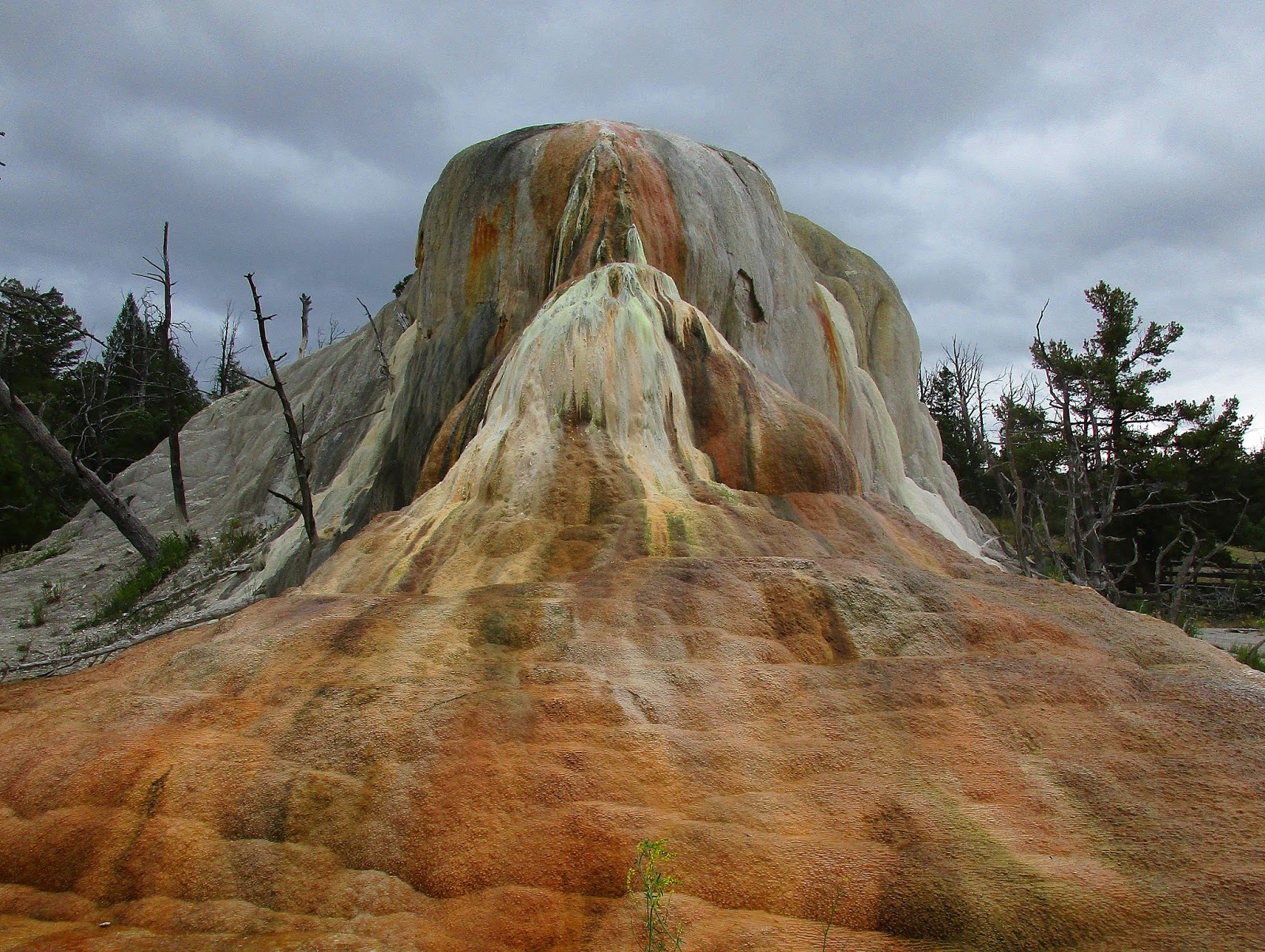
Orange Spring Mound

New Highland Terrace

We walked a little bit of the Lower Terraces area, a series of boardwalks with more features that defy description

The rain set in and the temperature dropped.  We were delighted to check into the Mammoth Hot Springs Hotel, luxuriate in a hot shower and have a very short lie-down on the comfy queen-size bed before moseying over to dinner at the Dining Room.  At the bar we got into a conversation with three college age guys who were working on a ranch for the summer.  Where did they go to school?  University of South Carolina.  Small world. 

Rained all night. 

“Nature never hurries. Atom by atom, little by little she achieves her work.”  ~Ralph Waldo Emerson

Tuesday, October 6, 2015

Yellowstone National Park: Avalanche Peak & More


Yellowstone National Park – Day 5 – Avalanche Peak and a Whole Lot More – 7/26/15 – 5 miles

My favorite day of our Yellowstone trip – two like-minded people, traveling light, making choices as we go along is so enjoyable.  Having one or two goals per day, not overplanning, is key and leaves room for more exploring and more relaxing.  Also following Eleanor Roosevelt’s advice of “Do one thing every day that scares you.”  On this day it was Avalanche Peak.

Avalanche Peak is near the East Entrance to Yellowstone NP bordering the Absorka Wilderness and Shoshone National Forest.  It is part of the Absaroka Mountain Range.  This destination would have been simpler from our home base in Canyon Village, but that didn’t work out and consequently we had a longer drive from our new home base at Madison Campground. 

But we had a black bear sighting along the way

We drove through Hayden Valley, a sort of half-scale Lamar Valley also known for wildlife viewing especially in the early morning hours.  This part of the Grand Loop follows the Yellowstone River upstream toward Yellowstone Lake. 

Buffalo roaming in Hayden Valley

Shore of Yellowstone Lake near Steamboat Point – keeping our eye on the sky with a little bit of rain to the west

Swaths of dead trees in this area of Yellowstone look like the result of fires, but the pine beetle is the real destroyer.  Many researchers believe this is a result of climate change – hard winters used to kill off the beetles that bore into the trees but now they are surviving the milder winters and munching away.

Along the drive to the trailhead, Jim and I were getting nervous that we didn’t have bear spray.  We’d read the guidebooks, seen the signage in the visitor centers strongly encouraging hikers to carry it, but just hadn’t faced up to it.  Why not?  I carried it with me when I hiked in Glacier National Park (borrowed from a friend).  Were we too cheap?  Were we in denial?  I should have read this blog post before we went.  So far we had felt safe on popular trails (a misperception because bears like to go where people/food are.)  But this section of the park seemed more remote, less people and more… I don’t know, bear-like.  We agreed to stick together like glue, keep our eyes peeled and make a lot of noise on the trail.

At the parking lot a family consisting of mom, dad and two teenage boys were preparing to start the same hike with us.  They were from Georgia and this was their first serious hiking experience out west. They all looked well equipped – in fact, the woman and I had the same Leki hiking poles and Osprey daypacks.  I noticed all the males were carrying bear spray.  The dad was also carrying a firearm – first time I had seen that in a national park, although they have been legal since 2009.  We talked about the possibility of grizzlies and the dad actually offered a bear canister to Jim (which he took) with the agreement to return it at the parking lot after the hike.  Well, that felt a little safer, except for the loaded gun part.

 [The woman asked me if I realized that this was a Category “H” hike?  I kinda shrugged, not understanding what she meant, and replied that I knew it was over 10,000 feet.  It is well documented that I am susceptible to altitude headaches and difficulty breathing above 10,000 feet, so I was anticipating a struggle. Later on I read in Hiking Yellowstone that the author categorized Avalanche Peak as Category “H” for “horrible,” tongue-in-cheek meaning extremely steep.]

Avalanche Peak Trail ascends 2,100 feet in 2.1 miles and does not start off gently.  It is serious from the first step, no switchbacking nonsense. 

That means stopping often for flower photography

At 1.2 miles the tree line ends and the “mountains majesty” views begin.  The trail curves steeply up through a scree field that made me whimper at the thought of the return descent.  (Click to enlarge and see the tiny person on the far left of the photo.)  This guy was hiking in flip-flops!

At least there were some switchbacks now and choices of routes across the talus fields, some steep and some steeper.

Yes, that's a trail

The trail we chose took us to the ridge line at the saddle point between peaks where this rock bunker offered some shelter from the blustery wind.  (Yellowstone Lake is in the background.) The peak to the west was slightly lower than the true summit of Avalanche Peak to the east.  We arrived about the same time as our Georgia friends.

I’m almost there

At the summit

Or is it?  The ridge line continued on through another slight dip and then ended where thoughtful hikers had built two more rock shelters.  We all settled down to eat lunch and gaze upon God’s amazing handiwork.

Yellowstone Lake to the west

Hoyt Peak to the south

Silvertip Peak to the northeast

The wind took Flip-flop Guy's hat and he chased after it.  We saw him at the parking lot after the hike and his big toe was wrapped in a great big bandage.  But he was still all smiles.

Time to head back

Talus or scree?  The debate rages on.  My interpretation is that scree is pebble sized and talus is hand-sized or larger.  They feel different on a descent.  Scree feels like you’re going to slip, your feet are going completely out from under you and you’re going to break your neck.  Talus seems to move just a little bit and is easier to walk on, although I’m sure your neck would be just as broken if you fell.  Maybe it’s all in my head.  Anyway, the hike down required great concentration. 

A flat spot!  I don’t remember this on the way up!


The remainder of the descent was still not a breeze, very steep and requiring caution and creaking kneecaps.  At the parking lot we were feeling elated after a successful climb (no bears, no injuries) to a lofty height (10,566 feet and still breathing). 

But the day wasn’t over!  We decided to scratch our semi- planned second hike of the day at Elephant Back Mountain and enjoy a leisurely drive along the west shores of Yellowstone Lake. 

Found a secluded peaceful spot to plop down our tailgate chairs and have a little siesta. 

Continuing around the lower Grand Loop, we skipped Lake Village and West Thumb (we’ll be back someday, right?) and stopped at the Old Faithful area to treat ourselves to dinner at the Snow Lodge Obsidian dining room (lamb, roasted root vegetables, creamy polenta).  With a couple of hours of daylight still to go, on our way back to Madison campground we drove around Firehole Lake Drive, nearly deserted.

Firehole Spring

Surprise Pool

Great Fountain Geyser

“Day is done, gone the sun
From the lakes, from the hills, from the skies
All is well, safely rest
God is nigh.”