Monday, May 23, 2016

AT in TN: A Peaceful Day Ends


Appalachian Trail in TN – 11/13/15 – FR 253 Southbound to 19E – 14.1 miles

It seems that three weeks is the longest time period I can stand without a massive injection of Vitamin “N”ature.  Fortunately, my part-time work schedule allows me Fridays off and overnight escapes allow me to be back home for church on Sundays.  All that’s left to contend with is the weather forecast.

This time out I chose an obscure portion of the AT in Tennessee, closing a 26-mile gap between 19E and Dennis Cove Road.  I arranged a shuttle ride with Mary of Mountain Harbour Hostel.  My plan was to hike southbound from the midpoint, tent overnight at Mountain Harbor, then shuttle with Bob Peoples of Kincora at the other end back to the midpoint and hike northbound.  Sounds complicated, but not really, and I’d save a little money and a lot of time. Plus it’s fun to figure out these logistical puzzles.

The forecast for overnight temps in the 20’s got me to rethinking my options as I drove to Mary’s in the early morning light. 

Mountain Harbour Hostel

The trailhead was one of the most remote I’ve ever seen – thank goodness I wasn’t trying to find it on my own.  At 10:30 a.m. I began my southbound day under a stellar blue sky, crisp 40’s, hearing the wind high and light in the trees but not really feeling it. 

Upper Laurel Fork

A good reminder of south versus north.  It’s easy to get turned around especially when you camp by a pretty stream. 


The first seven miles ticked off quickly, very flat, moving along at a good clip. Suddenly there was Mountaineer Shelter looking very new, built in 2006.

Sleeps 14 on two levels

Mountaineer Falls may be significant sometimes, but it was a mere dribble today

I lost track of mileage referencing AWOL’s guide, still moving faster than my normal pace, and passed numerous campsites not mentioned.  I kept looking up!

I got my bearings straight again at the Elk River as the trail followed an oxbow bend going upstream, passing through a skinny open meadow.  Why wasn’t this noted in the guide? 

A methodical and determined woodpecker dined here

Looking for Jones Falls, I tried one side trail that led instead to a really nice secluded campsite beside the river.  After retracing my steps back up to the AT, I encountered two hikers who told me that Jones Falls was a little bit further, indicated by a wooden sign.

The rock wall of Jones Falls is impressive in height even with low water like today.  I can imagine this after significant rain fall.  I wonder how it ices up during a cold winter?

With ten miles on my legs now, I slowed down a bit for the only significant climb (which wouldn’t have been even an eye blink at the beginning of the day).  At least the pine needle carpet was easy on me.

The trail crosses Buck Mountain Road near the church of the same name and winds behind Isaacs Cemetery. 

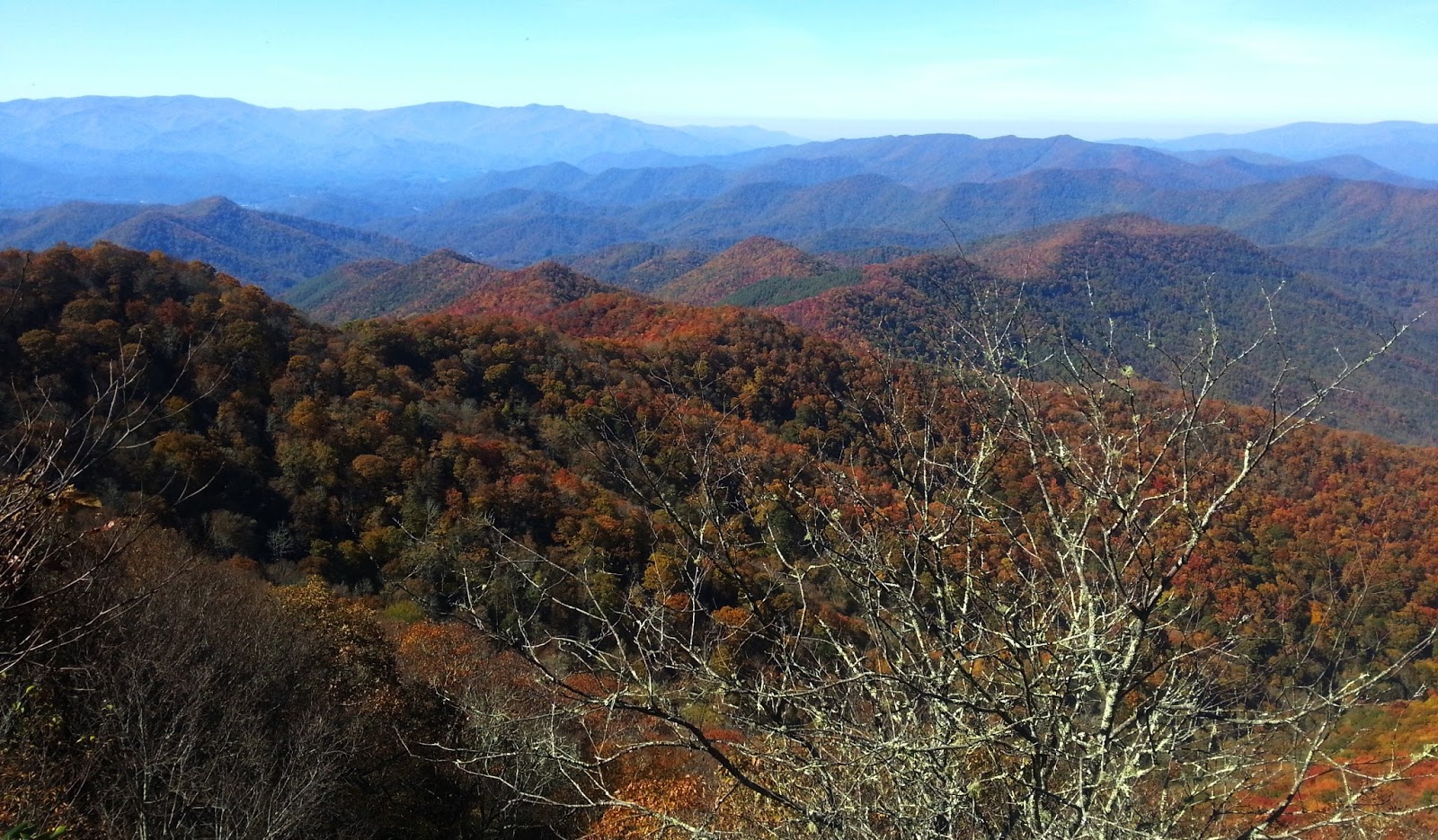
After another short uphill beyond the cemetery, the trail reaches an open ridge with some sunbeam views
Tiny bumps on the horizon are Grandfather Mountain!  Thrilling to spot the old guy from this vantage point.

A fuzzy closeup

Shall we call this Grandfather Tree?

The remainder of my hike followed jeep paths through more open meadows, over road crossings and piney woods before popping out onto 19E for the short walk back to Mountain Harbour.  Including my side detours, I had walked 15 miles in 6 hours and was filled with the peace and restoration of a day in the woods.  I made the decision not to camp overnight, but to go home to a warm bed.

During the drive I turned on the radio and learned of the suicide bombing attacks in Paris. Peace shattered.

“Lose yourself in nature and find peace.”  ~Ralph Waldo Emerson

Sunday, May 22, 2016

AT in NC: Close Encounters


Appalachian Trail in NC – Brown Fork Gap Shelter to Fontana Dam Visitor Center – 10/24/15 – 13 Miles

As the voices drew closer I removed my ear plugs and my heart commenced pounding.  Male voices, not trying to be quiet, one singing in a drunken-sounding slur and the other mumbling with occasional discernible phrases.  I heard the plop of a backpack landing on the shelter’s wooden floor and then one voice said, “Hey, there’s a food bag hanging up here.  And there’s a tent.” 

My bright pink tent that screams female. My mind racing:  These are not the hikers I met earlier. These are not ordinary hikers who would be very quiet and also would not be rolling in at 2:00 a.m.  This shelter is several miles from any road access.

Is this a dangerous situation?  I feel very vulnerable.

Next set of thoughts:  They don’t know who is in this tent.  It could be one female, two females, a male-female couple.  Maybe a dog (although no barking).  Maybe all of the above plus a gun?

Round 3:  What will I do if they approach me?  A:  Snore deeply.  B:  Answer in a gruff voice to quiet down.  C. Tell them to back off or I’ll shoot.

They didn’t approach me, but the talking/singing continued, and I slowly began to comprehend that this was ONE person, quite used to conducting a running dialogue with his own company.  Did this make me feel better or worse? 

Answer:  Worse.  If something happened to me, there would be no help.  All the concerns and warnings about being a solo female backpacker echoed in my head. 

As the panic train began accelerating down its track, the voices stopped talking – and began to snore.  The guy had simply laid down on the shelter floor and fallen asleep.  Eventually I dozed as well, and although occasionally I heard coughing, that was how the rest of the night went.

By 6:30 a.m. I was wide awake and making a plan.  The sun wasn’t up yet.  I would pack up as quietly as possible, abandon my food bag hanging six feet away from my shelter friend, and get out of there.  My planned goal was to hike to Fontana Dam, 13 miles, but there were a couple of road crossings and I could bail out if I still didn’t feel safe.  If this guy woke up and seemed threatening, I would try my best to outrun him. 

I packed up quietly inside my tent.  When I stepped out and began to strike the tent, the hiker woke up, sat up, and said, “Good morning.  I apologize for my noisy entrance last night, but by the time I saw your tent I knew I had already disturbed you and it was too late to look for another shelter.” 

Hmmm.  I smiled and said politely that it was perfectly all right, the shelter was for all hikers (geez, what is it about us Southern women that we need to be nice even in the face of something so wrong?)  We had a short conversation (while I continued to pack as quickly as possible) and he introduced himself as a southbound thru-hiker, meaning he was going in the opposite direction I planned.  He had stopped for pizza earlier and delayed his intended mileage, and he was used to night hiking, thus his arrival at that ridiculous hour.  I wished him good luck with completing his hike, shouldered my pack and walked nonchalantly up the path to the AT, on hyper alert for sounds of being followed.  Never heard or saw the guy again.

Months now after this experience, some observations and decisions:  I am very glad that I did not choose to sleep in the shelter and instead pitched my tent.  I want to continue hiking solo on occasion but I will take more safety measures.  I will never carry a gun, but having pepper spray is a reasonable precaution.  And as much as I love my pink tent, maybe I should invest in a camouflage one for my solo ventures?  Bottom line, the southbounder was harmless, as 99.99% of hikers are, but next time I will be better prepared and carry some peace of mind. 

What happened the rest of the day?  Well, I went hiking.

A recent blowdown on the trail

At Cody Gap there were three tents set up, a little campfire going and several guys in various stages of caffeine intake.  I asked if they had met an odd backpacker last night – yes, he had stopped at their camp to talk but they were glad when he moved on – and they offered sympathy when they heard about my encounter.  As we talked, a small dog came nosing up to me which I assumed belonged to the group until I noticed its radio collar.  They explained that the dog had gotten attached to them on their hike in and had hung out all night, obviously very hungry. They had called the number on her collar and gotten a response that the hunter-owner expected she would find her way back to a road. When I turned back to the trail, guess who followed? 

She stayed on my heels for the next 2.5 miles until we reached Yellow Creek Mountain Road.  There I was hoping to get a cell signal to call the owner again. No signal, but as I took a break on the wooden steps by the road a truck pulled up.  The driver looked at the dog’s collar, said he knew who the owner was, and lifted her into the truck bed that contained several dog crates.  Nice neat ending. 

The remainder of my hike was nondescript and I was distracted with thoughts of strange men and strange dogs and how much I loved hiking.  When I reached NC 28, though, I was ready to put down my heavy pack and call it a day.  But… the AT winds for another 1.5 miles to the Fontana Dam visitor center.  It seems that the trail builders took extra care to stretch this bit out. 

For the thru-hiker, the shelter called the Fontana Hilton awaits, a comfortable place to land in a spectacular resort-type setting and free hot showers at the nearby visitor center (which I took advantage of before driving home).  This is where you take a deep breath in preparation for the 72-mile traverse through Great Smoky Mountains National Park.
Fontana Lake on the approach to the VC


Reasons why I love these overnight backpack trips:

It’s not difficult to find a two-day window to slip away

A mini-retreat, especially alone, from “ordinary life” demands and stresses

Significant hiking miles justify the driving miles

I get to places that I can’t reach in a long dayhike

It’s just one night, so I carry minimal food and no cooking

It’s just one night, so no matter what the weather, I know I’ll sleep in warm, dry comfort the next night.

It’s just one night, but It feels like a lifetime passes in the hours between leaving my car and arriving back at it – in a good way

In life, one has a choice to take one of two paths: to wait for some special day -- or to celebrate each special day.”  ~Rasheed Ogunlaru


Sunday, May 8, 2016

AT in NC: Up And Over Cheoah Bald


Appalachian Trail in NC – NOC to Brown Fork Gap Shelter – 10/23/15 – 15.8 miles

Re-acclimating to scripted daily life/work after my Iceland trip took a couple of weeks, but the mountains of North Carolina began calling.  More time ticked by before an opportunity arose for two consecutive days of freedom.  In total, seven weeks passed between the Laugavegurinn hike and hoisting my backpack again to meet the Appalachian Trail.  No matter how far I wander in exotic places, the green mountains patiently await my return.

I spent the preceding night in a cozy old-fashioned little room at the Hike Inn.  The next morning my shuttle driver, an AT section hiker and free spirit named Rene (trail name Legs), dropped me at the Nantahala Outdoor Center.  I shuddered at the memory of the day hike that brought me to this point.  Well, this time I’m hiking solo, unencumbered and at my own pace.  Bonus points for returning to the familiarity of David “Awol” Miller’s handbook The A.T. Guide with its elevation profile and marked waypoints.  Yes, I was one very excited backpacker looking at 29 miles of walking meditation.

Oh, and 3,313 feet of net elevation gain, eight miles up to Cheoah Bald starting right now.  Eight miles of steady uphill is pretty rare even on the AT.  Mind prep, a repetitive mantra, fresh legs, chocolate and a touch of insanity helps. 

I was in no hurry, enjoying the bright sun, crisp air and brilliant fall palette.  Mindful of going as light as possible, I left the backpacking stove and fuel at home.  I carried only one liter of water, filling up and treating more as I went.  Still, my backpack felt heavy after no hiking for seven weeks so I knew that pacing and frequent stops were critical. 
 
Sunbeams at the Jump-up looking out over Nantahala Gorge

Sassafrass Gap Shelter, time to take off that pack for a few minutes

Piped spring at the shelter

Fellow hikers were on the trail both coming and going, escaping the everyday grind and searching for (finding?) peace that Mother Nature always offers.  I met three young college women from Florida, moving very slowly and cheerfully, on their first backpacking trip.  Their “plan” was simply carrying food for five days, walk northbound, turn around.   I asked if they had trail names, and they conjured them on the spot – Squirrel, Pocahontas, Sailor Girl.  They were accompanied by a huge shaggy dog named Daisy.  I wonder how far they got.  I’ll bet they had a great adventure no matter the mileage.
Cheoah Bald, elevation 5,062 feet, the high point of my trip.  This is the northern terminus of the 100-mile Bartram Trail, created to follow the approximate route walked by William Bartram, a Philadelphian naturalist who traveled throughout the southeast from 1773 to 1777 and wrote extensively about the plants, animals and people that he encountered in Bartram’s Travels.

Can you imagine waking up here?  A grand site/sight for a human to spend a clear starry night.  How about during a thunderstorm?  

View from the other side of Cheoah Bald

The tiny community of Stecoah

At the summit I met another backpacking group, two men and one woman, who said they were planning to stay at Brown Fork Gap Shelter.  Nice to know who’ll be spending the night with me.

It’s a steep slide down from Cheoh Bald with a couple of bumps to Stecoah Gap where the AT crosses NC 143.  Fall colors were splashed through the trees and the sound of leaves falling in the stillness were like dripping water.  Really.

Blazing yellow at Stecoah Gap

Thirteen miles with my light (heavy) pack had taken their toll.  Fun and games were over as I climbed northbound out of Stecoah Gap.  The ominously named “Jacob’s Ladder” turned out to be a straight-up-the-mountain drudge, 600-foot elevation gain in .6 miles, rather than a technical rock climb.  The trick is to take very small steps, which many people count, but I’ve found that singing or humming a repetitive tune works well for me. 

Brown Fork Gap Shelter was small (sleeps 6), old, dark, three walls and a roof, no porch, painfully uninviting, so I opted to pitch my tent.  I’d arrived later than anticipated and no one had passed me, so I was not surprised to be alone.  I realized it would be dark within an hour, so not much time to evaluate a tent space, get water, eat, hang up my food bag.  Down by the creek there was space for a couple of tents, but I left them empty for when the party of three arrived.  Not many other suitable places, so I put up my tent about 10 yards in front of the shelter. 

Chores were completed and still no others hikers had appeared.  Had trouble getting a rope set up to secure my food, so I settled for hanging it from a mouse baffle at the front of the shelter overhang.

By 7:15 p.m. darkness had settled in and so had I, feeling a tad lonely and isolated.  I’ve never slept alone in a shelter and was glad to have my little pink castle. 

Woke at 11:00 p.m. to pee.  What is that glaring street light?  The moon!

Woke again at 2:00 a.m. to the sound of voices, but it wasn’t who I had expected.


On the recollection of so many and great favours and blessings, I now, with a high sense of gratitude, presume to offer up my sincere thanks to the Almighty, the Creator and Preserver.” ~William Bartram