Tuesday, December 8, 2020

Grandfather Mountain State Park: Popsicle Toes Hike to Calloway Peak


Grandfather Mountain State Park: Popsicle Toes Hike to Calloway Peak
2/1/20 – 8.3 Miles 

Popsicle Toes: Every year, Rick leads this winter hike for the Carolina Berg Wanderers.  It includes the Daniel Boone Scout Trail where I’d had an injury in June 2017, so I was eager to revisit the scene. We were a party of five: Rick, Cathy, Mike, Jim and me. 

Jim and I drove up from Charlotte early Saturday morning. Rick advised meeting at the Asutsi Trailhead, which is the only access to Grandfather’s east side trails when the BRP is closed – and Rick was right.  The temp at our start was in the 30’s with snow showers predicted for the afternoon. There was already a trace on the ground to get us pumped up, but our imagination fell far short of what awaited high on the mountain. This would be a hike we'll talk about in our rocking chairs by the fireside.

Here you’ll find great descriptions of the east side trails.

From the parking area, the .4-mile Asutsi Trail leads under the BRP and connects to the Tanawha Trail, where we turned left. The trace of snow quickly became an inch of white stuff.

Footbridge crossing Boone Fork

A quarter-mile along the Tanawha Trail we turned right onto Nuwati Trail for a steep climb (enjoy it now because we will descend by a gentler route). I didn’t feel winded from the effort – in fact, it felt refreshing to be outside, bundled up and hiking on a cold day. As the snow deepened, we slowed down to be careful with our footsteps.

Halfway up Nuwati Trail, we took a left turn onto Cragway Trail, a one-mile connector to Daniel Boone Scout Trail. The blustery wind in exposed areas pushed us to get back in the safety of the trees, but the elevation gain never felt taxing: there was no hurry. The snow was now sticking to the leaves and bare branches and I wanted to see it all.

Rick in the haze near Top Craig View

At Flat Rock, we turned right onto Daniel Boone Scout Trail and the climbing began again with two miles to go to Calloway Peak deep in the trees now, almost no wind. My lightweight fleece was getting damp from brushing against the bushes, so I removed it and put on my red rain jacket. Fresh snow was several inches deep on the trail, covering rocks and roots. Footprints of early bird hikers led the way.

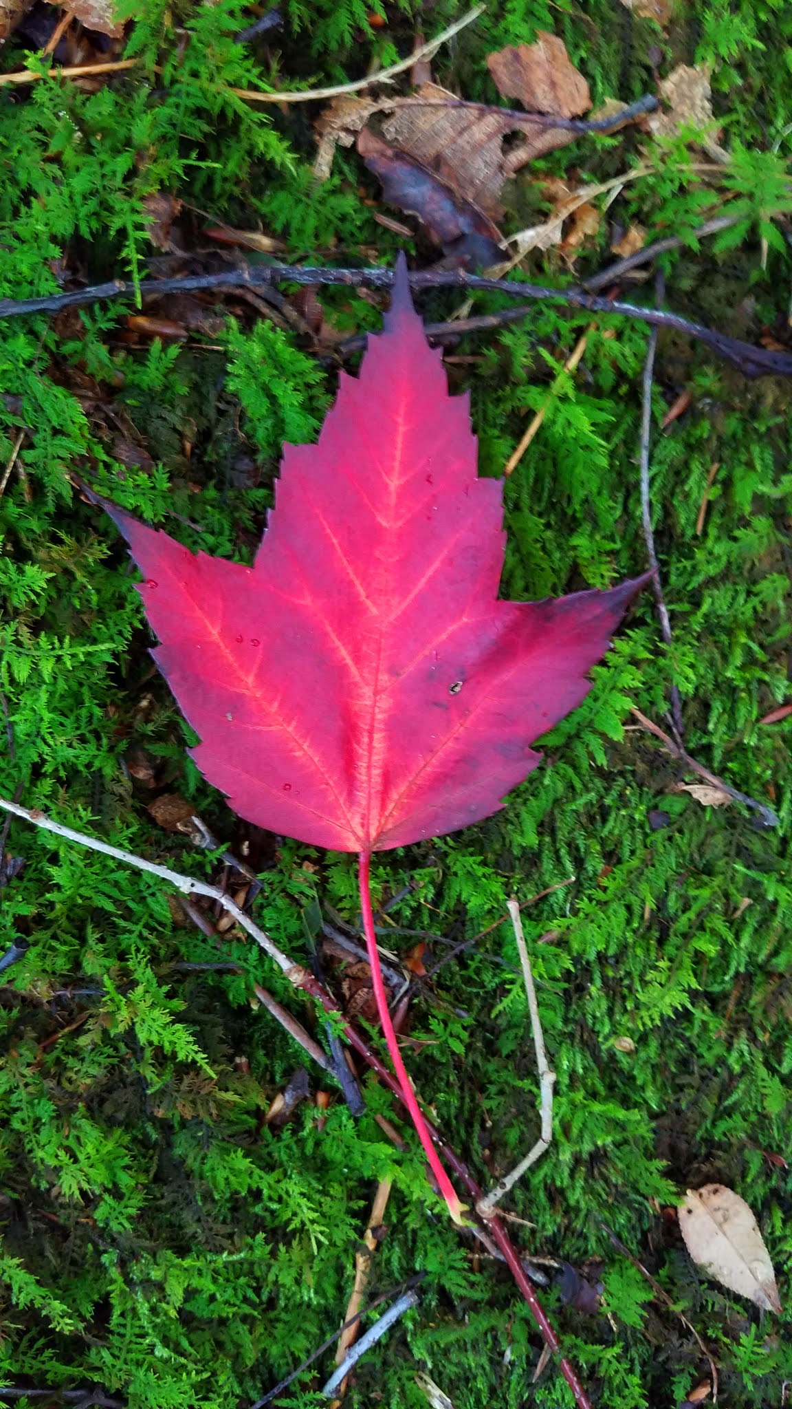
As we passed the Daniel Boone campsite I began to anticipate seeing my nemesis, the large rock surface where I had slipped and broken my shoulder on a sunny summer day…but my memory was fuzzy and everything looked different under this cotton-white blanket. Every turn in the trail was a new wonder, snow clumping on evergreen branches, clinging to the rhododendron leaves and stems of brown grasses. I gave in to the present moment.

We met the owners of the footprints as they came back down the mountain, one wearing shorts and hauling a seriously overloaded backpack (a training hike). They said the first ladder to the summit of Calloway Peak was covered in ice, so they turned back. Well, we knew that was a possibility, and we made an agreement that we would do likewise if it looked unsafe. For now, let’s continue to enjoy the day!

At 1:00 pm we stopped for a short break at Hi Balsam Shelter, a few dozen yards off trail to the left. Hi Balsam is an old 3-sided log shelter with the lowest overhang I’ve ever seen - Rick had to bend fully at the waist to duck underneath it. We ate lunch and got thoroughly chilled. We slipped crampons/snow spikes onto our boots for traction in anticipation of ever-deepening snow and hidden ice.

A cold day for the rhodies

 On May 5, 1978, a Cessna 182Q crashed near the foot of Grandfather Mountain’s Calloway Peak. The unnamed lone pilot perished. The remains of the plane are visible from the trail if you are alert for them. A short distance up from Hi Balsam, Cathy spotted a dull yellow color and footprints in the snow several yards to the right of the trail. The remnants of metal were sobering, so small and desolate, coated in snow.

Rick & me

And there was the ladder, looking beautiful and intimidating and beckoning us to be brave.

Do we turn around? Do we try it? Curious Cathy stepped on the first rung, then the second, and reported that they were not exactly icy. The ladder was snow-covered, but sturdy, and with slow careful steps we all climbed up, trying not to think about going back down.

Let's go for it!

The second ladder was taller and the top four rungs were leaning against dirt, covered in snow, with no way to wrap glove-covered hands around the rungs. At the top of this one, a cable was bolted to 30 feet of rock wall, to enhance that feeling of safety I did not have.

As Rick and I waited our turn on the second ladder, we were awestruck by white wrapped around every small branch, like a coating of ice but soft like snow, as though the wind had blown the snowflakes sideways. Long icicles hung down from the embankment as if they were roots of snow-covered trees growing above.

The third ladder was shorter, leaning at a daunting 60 degrees, but we're all in now.

The trail continued another 100 yards, moderately steep so still claiming our attention.  Suddenly we popped out onto Calloway Peak (5,964 feet). We were enveloped in a cloud, visibility just to the nearest trees, the sky a steely light blue-gray…a non-color…like nothing I had ever experienced before. The stunted evergreen trees had been dipped in white chocolate. The wind was not gale force, but stiff enough to make us shiver and quickly take photos in group combinations like a wedding party trying to get to the open bar reception.  

Going back down the ladders, we took our sweet time with photos and videos, and when one would act too confident, the rest would remind us how cold it would be waiting for a rescue.

Obstacles overcome, we moved quickly on our four-mile descent, spreading out and each moving with his or her own thoughts. Fresh snow absorbs sound, and I found myself alone somewhere between Jim and Rick. I stopped and listened to absolute silence.

Staying on Daniel Boone Scout Trail, we bypassed Cragway Trail. At lower elevation the snow thinned and tree roots and rocks reappeared. We took off our crampons. My right knee began to complain of the relentless downhill. We turned left onto Tanawah Trail, right on Asutsi Trail, back to the parking lot.

Did we really just do that??? We'll be telling this story around the campfire for years to come.

Everyone safe and accounted for - this group needs pizza and adult beverages!

“When snow falls, nature listens.” 
~Antoinette van Kleef


Sunday, November 15, 2020

Pisgah 400: Daniel Ridge Loop & Farlow Gap Trail to Shuck Ridge Creek Falls


Pisgah 400: Daniel Ridge Loop Trail/Farlow Gap Trail to Shuck Ridge Creek Falls
12/14/19 – 10.6 Miles


Have you ever done something on a hike that you look back and say, “Well, you left your good sense at the trailhead on that one, didn’t you?” Jim and I had one of those moments on this chilly backcountry waterfall hike (actually, two moments – we had to repeat it on the return). To our credit, though, we also exercised good judgment at a critical point.

Hiking all the trails in the Pisgah Ranger District presents quite a puzzle and I have realized that it cannot be done efficiently with just one vehicle, meaning there’s a lot of out-and-back trekking. The majority of trails are accessed by unpaved forest roads that are subject to seasonal and weather closures, and any access via the Blue Ridge Parkway is limited or nonexistent in winter. Planning, planning, planning!

Two goals: hike some new miles of the Pisgah 400 challenge and tag the Shuck Ridge Creek waterfall for the Waterfalls 100 challenge. I sold the idea to Jim, even though it didn’t involve a bike ride for him.

From Charlotte we had a foggy start but, as often happens, the sun broke through for a clear blue sky with happy puffy white Bob Ross clouds. We passed by the Pisgah Ranger Station/Visitor Center, scratched our heads wondering why its winter hours are just Monday-Friday (aren’t there a lot of visitors on Saturday and Sunday?) We turned left onto Forest Road 475, a pretty important road that winds deep into the southwest quadrant of the Pisgah Ranger District. Keep track of which segment you want: FR 475, 475B, 475C and 475D. If you get it wrong, you’ll learn a lot.


Our parking area was nearly a mile past the Cove Creek Group Camp – no other cars yet. Our planned route included the right half of Daniel Ridge Loop Trail (going counterclockwise), Farlow Gap Trail to the Art Loeb Trail intersection and return to pick up the left half of Daniel Ridge Loop to our car.


 We began on a gravel roadbed and crossed the Davidson River on a large bridge to the sign marking Daniel Ridge Loop. Turned right here, then walked a hundred yards further to peek at Toms Spring Falls (aka Jackson Falls, aka Daniel Ridge Falls). This is a lot of waterfall for very little effort.

Backtracking a little bit to rejoin Daniel Ridge Loop, we turned right and climbed quickly up the mountainside. The trail crosses a small footbridge over the innocuous little creek that becomes Toms Springs Falls as it pours over the massive rock face.


For the next two miles, Daniel Ridge Loop is mostly a clay-packed trail exhibiting mountain bike tracks, crossing open areas and skirting near now-closed FR 5046. Mountain biking is extremely popular in Pisgah NF, and hikers should stay attuned even on trails that are signed as closed to bikers. More than once I’ve been surprised by mountain bikers having the thrill of their lives – and shaving a few years off of my own.

We met hikers with their four-legged family members near the intersection with Farlow Gap Trail. Jim and I congratulated ourselves on our strong legs and fast pace. Thirty yards along on Farlow Gap, we stopped short at the banks of the Right Fork of Daniel Ridge Creek thundering down the mountain, with no bridge in sight. There was a big fat log perfectly positioned across the creek, suggesting that of course we could scoot across.

I straddled the log and began inching my way forward. Two feet into it, I realized three things: 

    My wet noodle arms are not very strong
    I was committed, impossible to go backwards
    This was a very dangerous thing I was doing

Eight feet above the thunderously pounding water, it took an eternity of leaning forward on my arms, lifting up my butt and putting it down, inch by inch. Fortunately, the trunk was solidly anchored with very little bounce. I’m not afraid of heights, but the idea of falling off and bashing my head on the boulders below had me repeating a mantra of “look forward, not down” until my feet were on solid ground. As I watched Jim scuttle across in half the time, I made a mental note that we would be doing it all again on the way back.

We continued on Farlow Ridge Trail as the old road bed wound around Fork River Ridge, kicking up leaves and breathing cool air, putting that scary log business behind us for now. Soon we heard rushing water ahead – Daniel Ridge Creek – and arrived at the edge to find no bridge. We scoped out the possibilities of a rock hop, then managed it without getting wet, as Jim grabbed my hand and pulled me across.

The deceptively easy trail now wrapped around Daniel Ridge and – of course – we heard the powerful crashing of Shuck Ridge Creek before we saw it. We weren’t expecting a bridge this time, but we were expecting to find a way across. Jim stood at the edge.


What the photo doesn’t show is that he was at the top of Shuck Ridge Creek Waterfall, where the water was squeezed into a three-foot-wide channel that plummeted out of sight. He paused to look upstream, then jumped across the channel. When he turned around, I was emphatically shaking my head: No, I was NOT doing that.

Jim acquiesced and then realized that jumping back was not so simple. The near side was smoother, wetter, more slippery. I covered my eyes – and there he was, back by my side. He began to make the case for trying again – “I did it once, I can do it again, and so can you!” It’s hard to admit defeat and not finish a hike, a bike ride, a challenge of any kind. But safety first: if one of us got injured, the other would have to go for help and leave the injured person alone in the cold for hours into the night, not to mention the risk to rescue volunteers. Never worth it.

Let’s enjoy the pretty blue sky for a moment as we turn ourselves around.

 We met the same obstacles on the return hike, first Daniel Creek and then the log at Right Fork Creek. Again we scouted upstream a bit, still no discernible alternatives, impossible to judge the depth or the rocks underneath the white water. This time Jim went first.

I chucked my hiking poles across the creek and climbed aboard. The log sloped up more from this direction, and a bump near the middle was harder to get over. I can’t say that I felt any braver or improved my time. When we were both safely across, though, I caught my breath at the realization of just what a dumb risk we had taken.

We turned right onto Daniel Ridge Loop Trail for the remaining 2 miles to our car. Along the way, Right Fork converges with Daniel Ridge Creek and Shuck Ridge Creek to form the mighty Davidson River that dominates this part of Pisgah National Forest, with small tumbling unnamed waterfalls all its own.

I’ve read a few descriptions of Farlow Gap Trail before and since this hike and they briefly mention easy crossings during normal flows (one of them mentioned a bridge over Right Fork but we saw no evidence of one). But one day of heavy rain can noticeably swell a creek. Jim and I took a stubborn and unnecessary risk crossing the log – we could have just waded across and gotten wet. (Heck, we could have waded through on the return.) We debated crossing at the top of the waterfall long enough to realize we didn't want to do it. Others may have jumped without a second thought. Moral: Consider your abilities and that you may be risking your life and the lives of people who will come to rescue you.

“Be still like a mountain
and flow like a great river." 

~Lao Tse Tung


Monday, October 5, 2020

Douglas Falls


Douglas Falls – 9/14/19 – 7.4 Miles


Doesn’t everyone have a file folder of hike plans for a short-notice-good-weather-forecast-gotta-get-outside occasion? Surely not just me…

I pulled up that file folder when Jim told me that he was going on an all-Saturday bike ride (becoming much more frequent). I’m chipping away at Carolina Mountain Club’s Waterfall Challenge and there are some outliers that call to me in these kinds of circumstances.  A three-hour one-way drive (aren’t they all?) but I had all day to do what I want… go hiking.

Two general ways to get to the falls from the NC Piedmont: drive around your elbow to get to your thumb, past Barnardsville to FR 74, for a one-mile roundtrip hike. Or enjoy a drive on the Blue Ridge Parkway and access the Mountains-To-Sea Trail from several points in the vicinity of Craggy Gardens. The Douglas Falls Trail intersects the MST.  I parked at the Visitor Center and hopped on the MST for a 7.4-mile roundtrip. Since I’m driving all that way, I want to walk more than a mile…

When I saw that first MST white circle I felt the thrill of reunion: Hello, old friend! I hadn’t been here since Danny Bernstein and I hiked the MST together back in ’09. I remember this part of the trail well, eyes glued to my feet on the slippery rocks. The rocks hadn't changed, still challenging. I followed the MST northbound for 1.2 miles to the intersection with the Douglas Falls Trail. From there it’s another 2.5 miles down, down, down to the falls.

The humidity was noticeable, even with the high 70's temperature. Even though stinging nettles crowded the path, I was too stubborn to zip on my pants legs.

The beauty of the forest surrounded me on all sides, above my head and at my feet.

Majestic old growth oak and birch trees
Moss carpeted logs
Splashes of red mountain ash berries
Twisted trees
Stump shelters
Fruits of fading summer flowers giving way to autumn asters
Tinges of fall

White wood aster

Goldenrod

Burl

Burl

Hearts a-burstin’

Gentian

Cucumber root

Fruit (blue bead) of the Clinton lily

Decaying fruit of false Solomon seal

The trail comes upon a house-sized boulder with a campfire on its downward side. A steep side trail leads to the left, probably to the waterfall, but the main trail goes right and switchbacks down to the waterfall base.

As often happens at a waterfall that takes some effort, I was alone. Douglas Falls is the big brother of Moore Cove Falls in Pisgah National Forest, a 70-foot free fall over a bluff, carving out a rock wall with a flow like a rain shower. You can walk all the way around the flow. While the volume of water is usually underwhelming, stand close to it and imagine a few days of hard rain spilling over the ledge.

Leaning back against the rocks, I ate lunch while watching the water splash. When I closed my eyes, the sound intensified, echoing back from the rock wall.  Around noon, as I stood and stretched, I heard voices coming up from the lower parking area:  a family, including two unleashed dogs and a toddler in a backpack. Good timing again as I hefted my daypack and set off.

The steep hike back up was hot and sweaty. I stopped once for an energy bar break, pacing myself, and I felt like I still had a bit of the Pembrokeshire Coast Path conditioning in my tank. Coastal cliffs or deep woods, outside is always good for the soles and the soul.

"To sit in solitude, to think in solitude,
with only the music of the stream 
and the cedar to break the flow of silence, 
there lies the value of wilderness."
~John Muir