Tuesday, March 31, 2020

Pisgah 400: Wading in the Water on the Riverside Trail


Pisgah 400 - Vineyard Gap Trail/Riverside Trail/Bradley Creek Trail – 6/15/19 – 9.2 Miles

Okay, I’m ready for another try at GAIA. I’ve uploaded the NatGeo map for Pisgah Ranger District. I’m headed to the Turkeypen trailhead. I’m planning a loop of 9 miles, but it’s not deep in the backcountry. Jim has my hike plan and a copy of the map. I’m goin’ in.


I’ll tell you up front that my hike was successful! I followed my planned route and didn’t get lost – though I may have been confused once or twice. The GPS boosted my confidence 1000% and I had a grand time. My counterclockwise loop route included a little out-and-back side trip to connect some dots. [I guess this was actually a lollipop hike starting at the top of the lollipop.] Here’s how the day played out.
  
Great day for a horseback ride. I wonder how many of these I’ll meet today.

Starting from Turkeypen Gap, I took the 2.3-mile Vineyard Gap Trail, a quick climb up and then a meander along Forge Mountain.

Pipsissewa: One of my top 100 favorite wildflowers because of the delicacy of the tiny flowers and the name is funny to say three times fast (did you do it?)

The last half-mile of Vineyard Gap plunges with no apology straight down to South Mills River. The track is muddy and horse trough deep.

At the water’s edge I confirmed that we had indeed had a lot of rain lately.  This was potentially the biggest crossing of the day, so I took the time to remove socks and shoes (my Salomons today, no boots) and waded through in bare feet.  The water was above my knees and incredibly refreshing. No, really!


On the far side, shoes and socks back on, and I realized I was in a spread-out campsite with little trails running everywhere.  After a bit of back-and-forth, I decided I’d found the Riverside Trail near the point where Bradley Creek flows into South Mills River. I turned right for a “quick” 3-mile out-and-back to its junction with Bradley Creek Trail.  Through fern fields and grassy wildflower meadows, with hardly any trail blazes to distract me, I followed upstream alongside Bradley Creek at a quick pace…until I hit another wet crossing.

Rhododendron

Robin’s plantain

Yarrow

I realized that all my care at that first crossing was for naught – I should keep my shoes on and barrel through, faster and ultimately safer than bare feet. Now I didn’t have to worry about wet shoes because I had ‘em.

Embracing the flow

There were two more wet crossings of Bradley Creek on the way to the junction – and that meant repeating the THREE crossings on the return.  So far I’m up to SEVEN crossings, all of them mid-calf or above the knees, but who’s counting? (ME.) The horses and riders I met along this trail were having a great time, by the way.

Okay, backtrack on Riverside Trail and now I’m cruising alongside South Mills River. The trail is pretty flat, my GPS is awesome, and who cares if the track is not exactly following the dotted lines? Fortunately the water felt quite refreshing, because I crossed the river SIX more times. Two of them were pretty darn wide and crotch-deep. By now I’d figured out that I was taking the criss-crossing horse route rather than the new-ish footpath that stuck to the right riverbank, but I was happy to keep splashing.

 
My first time seeing this plant: little brown jug or wild ginger – or are they the same?

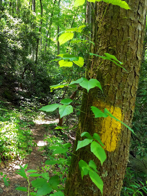
Poison ivy and a yellow blaze


At the intersection of Bradley Creek Trail and South Mills River Trail, I was in familiar territory and strolled back to Turkeypen Gap. I was really pleased to hone my GPS skills and I relished the water challenges on a hot day.  No slip-ups! No snakes! Success all the way round! 


"You cannot step into the same river twice." ~Heraclitus


Wednesday, March 25, 2020

Max Patch on National Trails Day


Max Patch on National Trails Day - 6/1/19


The first Saturday in June celebrates local, state and federal trails, recognizing the benefits and enjoyment of nature, promoting awareness of recreational trail services, and offering opportunities to give back as good stewards of our public lands.  This day of recognition has taken on significance in a myriad of way: hiking clubs host workdays, environmental organizations offer education workshops, state parks lead hikes, and hikers take to the trails. The PR machine works for months to get the word out to take a day to enjoy, give back and/or pay it forward to protect and honor the lands we love.

Carolina Mountain Club maintains 92.6 miles of the Appalachian Trail, including the area lovingly known as Max Patch. In fact, Max Patch gets “loved to death” and is in frequent need of trail maintenance and rehab. That’s the paradox of easy accessibility to a special place: you want people to come, but when they do, they wear it out. CMC sponsors a National Trails Day workday and I joined nearly 100 people in the 2019 efforts at Max Patch. How do you organize 100 people to work on a trail? With a lot of planning.

Getting our marching orders; tools provided, but some folks brought their own


Sections had been prepped for the day with gravel, fencing and other material put in place. Some groups worked on the signage area near the parking area, some filled in eroded tread, some worked on patches of invasive plants. I followed a crew chief in charge of rehabbing a short section of trail in the trees near the base of Max Patch. First we went through a lengthy getting-to-know-each-other exercise and detailed safety rules and precautions. We were tasked with widening our section of trail, digging out all rocks and roots and sloping the trail just right for drainage. Working in pairs, we spread up and down the trail.


If you’ve done trail work yourself, you know that you can’t keep it up for long, changing your work angle frequently or your back will tell you all about it later on.  Our trail bosses were incredibly picky about the precise grade! We took a short break to eat lunch on the trail as one woman identified every single birdsong (hard to hear the birdsong over all the commentary…)

Best part of the day: walking up and over Max Patch bald to join the rest of the crews. The sky, the sun, the clouds, the intensity of green and blue and white, were stunning.


 “When there is mist on the mountains, it is beautiful, and when there is no mist, it is also beautiful.” ~Thich Nhat Hanh


Sunday, March 22, 2020

Mountains-To-Sea Trail Training Hike


Mountains-To-Sea Trail: Training Hike – 13 miles – 5/5/19


A training hike, you say? With Danny Bernstein, eh? What is in the works? Read on.

I spent Saturday night at Danny’s home, woke up to a gray and rainy Sunday morning. Forecast was solid rain until 11:00 a.m. A little breakfast, a quick gear check (boots/pack/raingear/poles) and we’re off. A day hike in the rain might be postponed if you’re looking for views and sunshine, but we had on our “big girl panties” and no weather could deter us. We needed to practice hiking in the rain.

On the agenda, an out-and-back hike on the Mountains-To-Sea Trail starting at the Blue Ridge ParkwayVisitor Center near Asheville, destination Lunch Rocks. I had never stepped onto the MST from this point, and we had a bit of confusion on the blue blaze trail from the parking lot to connect with the MST, probably added a half-mile to the day: more training! We needed to practice being confused.


We hiked northbound 2.5 miles to the Folk Art Center, encountering stone steps, log bridges, a concrete tunnel, a railroad crossing, walking under the BRP and through a field of wet cows, crossing a bridge over US 70. (No photos, cameras safely stowed.) We needed to practice route-finding through infrastructure.

The relentless rain turned it up a notch to drenching downpour. Everything attached to my body was saturated.  At the Folk Art Center we sloshed into the bathroom. I did my business and wrangled my wet clothes back into some semblance of order.  Back outside, I sat on a bench, removed my boots and wrung out my sopping wet socks. Put them back on my wrinkly feet, still wet but no longer sloshing, and so far no hot spots - it really did help. We needed to practice saturation with a smile.

  
As promised, the rain stopped at 11:00 a.m.(I looked at my watch.) The clouds dispersed and the sun came out. I had resigned myself to a full day of rain, my hood pulled over my face, my vision limited to my boots splashing on the trail, very little conversation as we gutted out the miles. Amazing how cessation of precipitation can change an attitude – and how sunshine can bring on amnesia that it ever rained at all! We needed this day to remember in our adventures to come.

The foliage was still dripping wet, of course, magnifying the intensity of green everywhere. We continued another 2.5 miles on the MST to Lunch Rocks, a popular rock outcropping to take a break, eat and enjoy the view.

  
Rejuvenated by the improved weather, Danny suggested pushing on another half-mile to the next high point, so we did. About ten minutes up the trail, we were rewarded with clumps of pink ladyslippers.


The rest of the day was green and wildflowers and walking blissfully on a gentle downhill back to where we started. Cameras out – let pictures tell the story.

Lyreleaf Sage

Flame Azalea

Putty Root Orchid (Adam and Eve) - a first for me


What are Danny and I training for? The Pembrokeshire Coast Path – 186 miles in Wales!


“The greatest adventure is what lies ahead.”  ~J.R.R. Tolkien


Saturday, March 7, 2020

HIKE For Mental Health: McDowell Nature Preserve


HIKE For Mental Health – McDowell Nature Preserve – 5/4/19 – 3 Miles

 
Sometimes you know something in your gut without explaining it in words. Recently there’s been a lot of press about how spending time outdoors is good for one’s mental health – well, gee, I could’ve told you that!  But in stepping back, exactly how could I tell you that – in words, I mean?

Hiking makes me feel energized, relaxed, peaceful, reflective, worry-free, that good kind of tired…but even those words don’t capture all the feels. How about this one?

Ineffable: too great or extreme to be expressed or described in words

Taking someone on a hike is one of my favorite things to do because my words are not necessary. I notice my friend’s body language, hesitation, self-consciousness, curiosity, increasing confidence, and then that letting go of worries for a little while. The worries are still back there, but time spent outdoors, no matter how brief, can renew the spirit to pick them back up again. Sometimes that’s hard to put into words – is the feeling release? Respite? Relief? Renewal? Ineffable?

People who have loved ones with mental health issues often put their own self-care on a distant backburner. Has that ever happened to you? “My sister suffers from depression and I focus on her even when I’m exhausted. My child has been recently diagnosed and I’m hell-bent on making his life better. My dad seems so sad since Mom died and I’m spending every minute with him so he won’t be alone.” There is a situation in nearly every family or extended friendship family (although it may not be put into words.)

HIKE For Mental Health aligns with my love for the outdoors and my intense interest in mental health research. Their goal is raising awareness of mental health challenges and funding for research, along with self-care and care for loved ones. I participated in an event a couple of years ago that was really impactful. Kept it in the back of my mind until February 2019 when I decided to create and manage a hike of my own to benefit the organization – more importantly, to raise awareness that there is help.

Where to hike and who’s going with me? I chose McDowell Nature Preserve in Mecklenburg County for its beauty, its trails along the Lake Wylie shoreline, and its easy accessibility from Charlotte. I planned a 3-mile route and hiked it several times between February and May so I would look like I knew what I was doing!

In early May 2019, 13 people took the time on a warm Saturday morning to walk together at McDowell Nature Preserve. My husband, Jim, was the sweep while I took the lead. Everyone had a map that we worked on interpreting at intersections to stay on track.

Our little group stopped at a halfway point where picnic tables sat beside a stream – and disturbed a big black snake that splashed into the water to get away! During our break I shared a letter from HIKE For Mental Health about recent research grants it has funded. We talked about how just about everyone you meet in life has been touched by a mental health issue extending to family, friends, and co-workers’ families and friends. I shared a recent obituary in our local newspaper about a young man who “lost his battle with depression,” noting that the family was very brave to make their son’s struggles public and that it would help someone.

I walked a little bit with each person and heard stories of a son who died by suicide, a deceased father who was undiagnosed but obviously suffered from depression, a brother struggling in addiction. Some carried thoughts of loved ones, some carried concerns for the world today. We all carried home a little hope for tomorrow.

Only two folks in the group (aside from Jim and me) had previously visited McDowell Nature Preserve and were very enthusiastic and visiting again and bringing friends and family – one of my goals for the hike. Pass it on!

All in all, a wonderful morning outside honoring and supporting people who struggle with mental health and those who love them. The HIKE For Mental Health organization was easy to work with and I look forward to hiking for them again in the future.

(Photo credit and thanks to Danny Bernstein who also hiked with us.)

“I go to nature to be soothed and healed and to have my senses put in tune once more.” ~John Burroughs