Wednesday, December 29, 2021

Hanging Rock State Park: Three Sisters Off-Trail Hike

Hanging Rock State Park: Three Sisters Off-Trail Hike - 12/12/20 – 6.9 Miles

At the end of Sheep Rock Road on the outskirts of Danbury, NC (yes, outskirts) there’s a gate. This unassuming gate is a back door into Hanging Rock State Park – legal entry, rarely used, and a prime location for a solitary winter’s day hike – yes, yes, yes!

I didn’t find this gem on my own. I joined a hike led by Joe Miller on a cool COVID-19 morning in December 2020. I was thrilled at the opportunity to follow the footsteps of an experienced and trusted outdoor adventurer. [Check out GetGoingNC to be amazed at Joe’s passion and all he does to get people outside. The website includes a guide to this hike so my description here is only general, with photos that make you want to go!]

At the gate, I set my GAIA to make a track as we headed out on the gravel road past an old tobacco barn. Following Joe, trending uphill, we switched from one roadbed to another until we left gravel altogether and climbed up through the sparse undergrowth to the ridgeline (one of many reasons to hike off-trail in the wintertime).

At around two miles we summited the Second Sister, then half a mile later topped the Third Sister. We walked along a saddle up to a fourth peak (unnamed) and over to a rock outcrop with stunning views of Hanging Rock to the west.

From that turnaround point, we loosely retraced our steps, exploring more rock outcrops with views to the southwest. On the return we also made the short side trip to tag the First Sister (no view). Didn’t see any peeps the whole day.

Joe Miller

Joe shared tips on off-trail sight navigation, and comparing my GAIA track with the GPS of other hikers was a valuable learning exercise for me. I don’t profess to be prepared for solo tripping off-trail everywhere, but I think I could repeat this hike in similar (winter) conditions using the track I made.

New area, new skills, winter views and solitude – it doesn’t get any better than that. I drove home with a big ol’ smile on my face.

I repeat: Do yourself a favor and check out GetGoingNC, especially the blog posts and archives. Joe is based in the North Carolina Triangle (Raleigh-Durham-Chapel Hill) but he offers guided hikes in a broader area, and his guided backpacking trips (for beginners as well as experienced folks) are the best you can get for skill building and exposure to some great areas in the NC mountains and beyond. 

“I have discovered in life that there are ways
 of getting almost anywhere you want to go,
if you really want to go.”
~Langston Hughes


Saturday, December 18, 2021

Hickory Nut Gorge: Trombatore Trail

Hickory Nut Gorge: Trombatore Trail – 11/21/20 – 5.5 miles

Blue Ridge Pastures - Bearwallow Mountain in the foreground

Hiking with your kids from an early age reaps rewards for decades. Beyond the foot-dragging and how-far-is-it-NOW grumbling, they learn skills and eventually gain an appreciation for the outdoors. It is particularly wonderful when they come back as adults and join you voluntarily for a walk in the woods.

During an extended home visit, our daughter Megan joined Jim and me for an exploratory ramble in Hickory Nut Gorge, a treasure trove of conserved lands in the Blue Ridge Mountains near Lake Lure, NC, southeast of Asheville. Conserving Carolina has been at work partnering with private landowners, building trails faster than I can explore them. Today we walked out-and-back on the Trombatore Trail near Gerton, NC.

On this sunny Saturday, cars were parked all up and down the sides of the gravel road at Bearwallow Gap. A church van was unloading a crowd of chatty young people. The masses were heading to Bearwallow Mountain, a two-mile roundtrip hike to a grassy meadow. There is an historic fire tower at the summit that Jim and I visited years ago (read about that hike here).

Where all those folks went one way onto Bearwallow Mountain Trail, we turned the opposite way onto Trombatore Trail for a longer, more relaxed hike to another grassy (more remote) meadow called Blue Ridge Pastures.


Megan

Trombatore Trail meanders along a couple of long switchbacks down to Brush Creek, then climbs up the next mountain, alternating between trail and gravel road track. Obvious trail markers kept us on the right path as we crossed a couple of these roads. We passed below impressive mountain cabins sitting on top of the ridge, which would be hidden from view in other seasons.

Winter palette

After passing through a turnstile, the world opened up at Blue Ridge Pastures. The bald is a front row view to Bearwallow Mountain, where those with sharp eyes can see the fire lookout tower (see top photo). Currently the trail ends there, but plans are in the works to extend the trail for three miles to Hickory Nut Gap on Highway 74A.  [Pause to say thanks to the property owners who graciously give access to this amazing place.]

We walked to the far end of the meadow, ate our lunch, and struck a few victory poses.

As often happens, on the return hike we passed mossy boulders and stone steps that we didn’t remember. The flow of outbounders increased, including a number of families with small children – I wonder how many made it to the bald? Or maybe just down to Brush Creek to throw rocks in the water?

Happy hikers

Celebration time at Hickory Nut Gorge Brewery – a perfect ending!

“Lovely days don’t come to you;
you should walk to them.”
~Rumi


Wednesday, December 8, 2021

Little Lost Cove Creek Waterfalls & Darkside Cliffs Trail

Pisgah National Forest: Upper & Lower Little Lost Cove Creek Waterfalls &
Darkside Cliffs Trail – 10/31/20 - 5.8 Miles


The last day of October may be all about ghosts and goblins, costumes and candy…but it’s also a great day for waterfall hunting in the North Carolina mountains. At the upper elevations most of the leaves have found their way to the forest floor, making off-trail exploration easier, and there’s a delicious chill in the air.

Hiking buddy Cathy invited me for a visit to her mountain cabin – yes, thank you! The two of us and her pup, Ellie, explored the Harper Creek Wilderness area of the (deep breath) Grandfather Ranger District of Pisgah National Forest. Specifically, we were looking for (another deep breath) Upper & Lower Little Lost Cove Creek Falls from the Waterfalls 100 Challenge that I’ve been chipping away at.

From the Blue Ridge Parkway, we made our way to FR 464, then traveled it eastbound to an “old forest road” called FR 464-A, where my usually adventurous Honda CRV crept cautiously downhill to a creek crossing. I was hesitant to drive through the creek – when was the last time you hit a big rock and busted something – so we left the car and set off on foot.

Ellie says, “Let’s walk across.”

Half a mile further down, the road ended where a pickup truck was parked next to a rough roadside campsite. Interpreting vague hiking instructions, from that point we followed an unmaintained track, severely eroded, with numerous blowdowns blocking our progress. Ellie is a good girl, but Cathy kept her on a leash because she’s been known to catch a scent and take off. 

Ellie says, “Let’s go under,” as Cathy tries to step over a blowdown while holding onto the leash.
Ellie usually wins.

I started a GAIA track for the out-and-back. We could hear the creek on our right side and found the correct side trail. We knew we were going towards the booming waterfall, but the trail itself was barely discernible.  A few yards in along the side trail, we saw three big backpacks piled up under a rhododendron bush – maybe they belonged to the folks from the pickup truck?

We half-slid and half-walked down the steep path until we glimpsed water through the tangled rhododendron. At that point the pitch of the slope became even more serious. I heard shouting and barking at the same time I saw the backpack owners at the foot of the waterfall. I also saw their unleashed gray-and-white pit bull. There are some sweet pit bulls in my life, but I like my unknown dogs leashed.

Cathy elected to stay behind with Ellie while I kept going, descending a 20-foot rope to reach the river’s edge. The waterfall was massive but half-hidden by a huge boulder, so a sketchy photo op at best. I didn’t try very hard to get a better vantage point because of the guys and the dog. They saw me as they turned to go back up the path. The tail-wagging dog bounded towards me and I figured I should try to be friendly, so I asked if I could greet him. One man said, “Now, he will jump on you,” but the dog only briefly stopped by me and then barreled his way on up the slope and out of sight.


Upper Little Lost Cove Falls

Cathy and Ellie and I pushed on in what we interpreted was the direction of the lower falls. After another steep downhill rhododendron scramble, we came out onto an open flat rock area where the creek was flowing fast over the cliff edge. This was near the top of the lower falls. We debated further exploration for the base, but bushwhacking without a clear goal was too much with Ellie. We retraced our steps to where we parked our car.

All that effort for 2 miles in 1.5 hours – whew!

[Later on I reread the instructions and better understood them – we’ll try again another day.]


Looking up to the top of Lower Little Lost Cove Falls

Looking down towards the base of Lower Little Lost Cove Falls

Next up: Bard Falls. We drove a little further east along FR 464 to the trailhead of Harper Creek Shortcut Trail, hiked one mile to the T-intersection with Harper Creek Trail (MST), turned left, hiked a quarter mile on this nice flat trail to a significant crossing of North Harper Creek. Stop.

I had hoped that the creek would be easy to hop across, but no luck. If I’d been solo, I would likely have waded through and continued on the next half-mile to the waterfall, but it was too cold to ask Cathy and Ellie to join in or to wait around for me, so we retraced our steps to the car. A failed attempt at the waterfall, but 2.8 miles and 1.25 hours of nice hiking anyway.

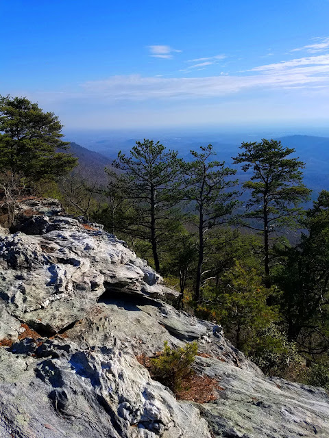
Ready to call it a day, Cathy and Ellie and I headed back up FR 464 toward the Blue Ridge Parkway. A trail sign caught our attention and we stopped to check it out. Darkside Cliffs Trail is a nifty one-mile trail leading to a broad, smooth rock outcrop and an incredible unobstructed view of Grandfather Mountain. I’d never heard of it, but now it’s in my back pocket as part of a great day trip itinerary along FR 464 in Pisgah National Forest.


Ellie says, "When you go rambling in the woods, sometimes you don’t find what
you’re looking for…but you always find something you weren’t expecting."

Ellie says, “Are we home yet?”

“Everyone thinks they have the best dog,
and none of them are wrong.”
~Anonymous


Monday, November 29, 2021

AT in GA: Three Forks to Springer Mountain Summit

Appalachian Trail in GA – Three Forks to Springer Mountain Summit – 10/24/20 – 8.3 Miles

Summit Day! We were up and packed before sunrise, with a few extra minutes for Jim to make his required pour-over coffee by headlamp. He’s a trooper!

Changing up the day’s hike plan meant saving hours of driving to Amicalola Falls State Park. Instead, we drove slowly and cautiously on gravel FR 42, looking for deer in the early morning light, and met shuttle driver Mary where the road crosses the AT. We left our car in the last available legit parking space and she took us back to Three Forks, where we had started northbound yesterday morning.  Today we’re hiking southbound to the top of Springer Mountain.

Bridge at Three Forks

At Three Forks, cars lined the roadside and tents were scattered every which way on this fall Saturday morning. We passed clumps of NOBO section hikers who were still pumped after one day and one night on the trail. Full of anticipation ourselves, we cruised along the gentle three-mile uphill, and Jim was a little bummed that we weren’t going to hike down the Approach Trail too (his ankle seemed a lot better!)

We passed the FR 42 parking area and started the last mile of treads and rock steps placed by trail builders, necessary for heavy foot traffic. I could feel an invisible rope tied to my daypack’s sternum strap, pulling me up to the top. We chuckled under our breath as we passed the still-sleepy stragglers at Springer Mountain Shelter.

And then we were there at the summit of Springer Mountain, elevation 3,782 feet! Cloudy, no views, half a dozen people hanging out but not crowded – a surreal feeling to be standing at this iconic spot. 


This marks my completion of the AT through GA, NC, TN and VA – about 1,006 miles.
I didn’t know then that nine months later I would jump ahead and summit Mount Katahdin,
the northern terminus of the AT.

The two of us felt like superheroes now and backtracking a mile to our car seemed anti-climactic so…a quarter-mile from the summit, we took a right turn and stepped onto the Benton MacKaye Trail (BMT).

From this starting point, we followed the BMT for about 4 miles as it wound around Ball Mountain, passed through Big Stamp Gap, then turned west to cross the AT. From there we backtracked a mile to FR 42 where our car awaited. Beyond, the trail continues for nearly 300 miles north through Georgia, Tennessee and North Carolina, ending at Baxter Creek in Great Smoky Mountains National Park. [Learn more about the BMT here.]

,

Before hitting the interstate to get home to Charlotte, Jim and I meandered on Georgia backroads looking for a treat to celebrate our milestone, and we found it at Cooper’s Creek Store in Suches. Fried pies, y’all!

When I finish reading a book, it is my habit to start another book immediately – maybe I just don’t like endings. Walking the first several miles of the BMT got my juices flowing and my thoughts formulating as I recalled a challenging four-day section on this trail in 2018. Now, where did I put those maps?


"Keep close to Nature's heart, yourself,
and break clear away, once in a while, and
climb a mountain or spend a week in the woods. Wash your spirit clean." ~John Muir