Saturday, February 19, 2022

Waterfall 100 Challenge: Panthertown Waterfalls - Riding Ford Falls/Jawbone Falls/Greenland Creek Falls

Panthertown Waterfalls – Jawbone Falls/Riding Ford Falls/Greenland Creek Falls
Lake Toxaway Weekend – 2/28/21 – 6.2 Miles

[Note: Directions to trailheads for all the waterfalls we visited today are from Kevin Adams’ book North Carolina Waterfalls, Third Edition.]

Jim and I slept hard after our epic Saturday. I convinced him to go for three – only three! – more waterfalls before we headed back home on Sunday.

As the crow flies, today’s hike was just a mountain ridge away from yesterday’s, specifically the ridge between Cold Mountain and Shelton Pisgah Mountain.  The area is called Panthertown Valley and it is legendary for its rugged maze of trails and old logging roads, towering rock walls, backcountry camping and, of course, waterfalls. The secret has long been out of the bag and you won’t be alone in Panthertown, but it still has a mysterious, remote vibe.

There are numerous websites and blogs about Panthertown so I won’t list any here. Some worthwhile posts are dated a while back, so also look for the most recent info. Lots of people recommend the map “A Guide’s Guide to Panthertown” by Burt Kornegay, including me.

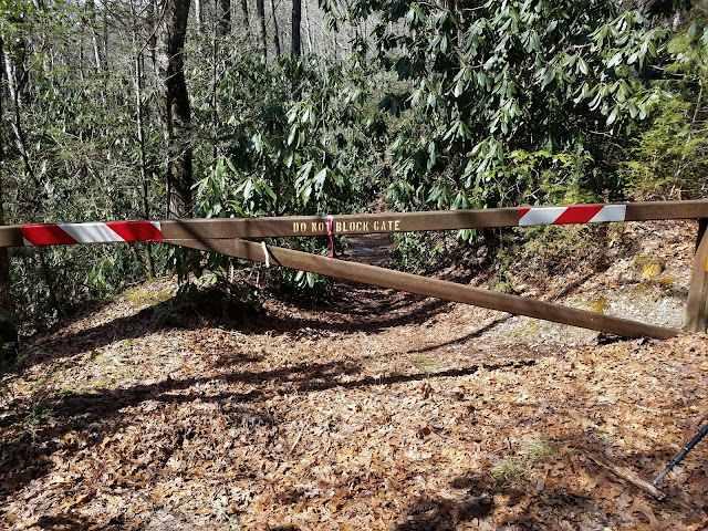
And if you’re going, make sure which trailhead parking area is best for your hikes: Cold Mountain (east) or Salt Rock Gap (west). Jim and I parked at the Cold Mountain Gap access for our hikes today. It’s an easy drive from the junction of US 64 and NC 281 at Lake Toxaway.

First up, Riding Ford Falls and Jawbone Falls: A steep, worn-out track descends from the parking area to turn right on a wide old roadbed (Panthertown Valley Trail). At the intersection with Devil’s Elbow Trail, we turned right again and passed under a power line cut that is ugly but memorable as a good landmark.

About half a mile past the cut, we turned left onto Riding Ford Trail and walked to the edge of the Tuckaseegee River at Riding Ford Falls. The trail continues across the slide (outside of the photo’s left frame) as horses and cars would have done back in the day. Not a dramatic waterfall, but mesmerizing to stand at the edge and imagine that crossing as an ordinary part of life.

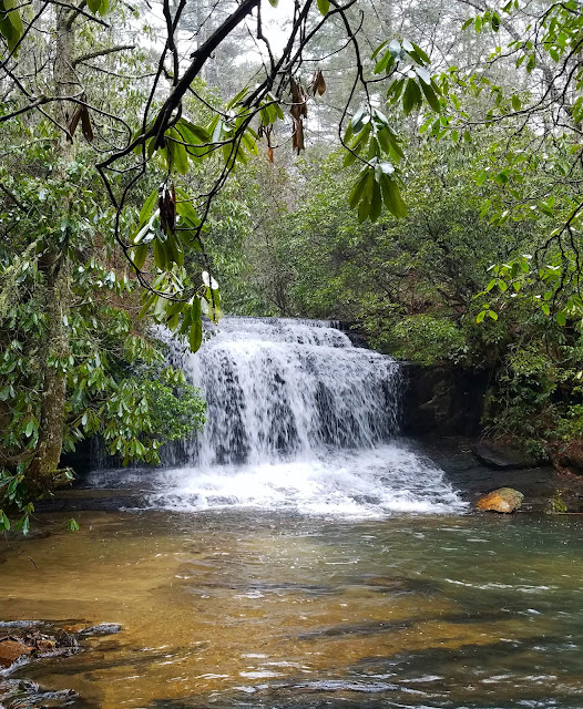
Jim and I stayed on the same side of the river, turning left into the woods where a magical path appeared leading through a wooded campsite. A few hundred feet further upstream along the creek bank, we reached the edge of a very large pool with Jawbone Falls pouring into it on the far side. (Read this great article about how this and other places get named.)

The beach and campsite area is huge with room for multiple groups, and whoever was there last
 had cleaned up very well.

If you need a walking stick…

We backtracked to the parking area, about 4.2 miles total for this leg of our hike. Next up: Greenland Creek Falls (Holly Falls).

As the article referencing Jawbone Falls says, natural features can have multiple names, referring to something that happened there or a person who “found it first". In this case, a local landowner figured this waterfall didn’t have a name so he named it after his daughter. Mostly it is known for the creek on which it is located.

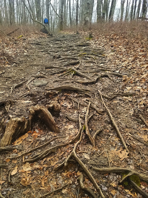
From the opposite end of the parking area, we picked up Macs Gap Trail for half a mile until it merged with Greenland Creek Trail. The two continued concurrently for a short distance, when Macs Gap Trail turned right and crossed Greenland Creek. Our trail stayed straight and shrunk down to a skinny path through rhododendrons, and the footing deteriorated to slippery roots in a muddy bog. Having fun yet?

The trail became rocky as we neared the falls, and the rocks grew bigger at each bend – an exciting buildup to the waterfall. What a beauty! (I’m sure Holly was a beauty, too!)

Greenland Creek Falls

We backtracked to the parking area again – 2 miles round trip - and made the long drive home. We were so fortunate to tag 12 waterfalls this weekend, no mistakes, no injuries. Let’s do it again!

Except we always forget about the painful re-entry back to our lives in the concrete jungle – an hour-long standstill on I-85.

“I can see my rainbow calling me
 through the misty breeze of my waterfall."
 ~Jimi Hendrix


Thursday, February 17, 2022

Waterfall 100 Challenge: Wolf Creek Falls/Upper Sols Creek Falls/Rhapsodie Falls/Lower Rhapsodie Falls/Dismal Falls/Aunt Sallys Falls

Wolf Creek Falls/Upper Sols Creek Falls/Rhapsodie Falls/Lower Rhapsodie Falls/
Dismal Falls/Aunt Sallys Falls – 6 miles - 2/27/21

Morning light on the porch was tempting, but we’re here for the waterfalls!

[Note: Directions to trailheads for all the waterfalls we visited today are from Kevin Adams’ book North Carolina Waterfalls, Third Edition, and are updated instructions from previous editions.]

Wolf Creek Falls Hike – 1 mile round trip

From the junction of NC 281 and US 64, Jim and I drove north on NC 281 for 12.7 miles, crossing Wolf Creek Lake Dam (the falls are downstream from the lake). About half a mile after the dam, we found a pull-off on the left, heeding instructions not to park at the nearby church. There were no other cars around and we didn’t see or hear anyone at the falls during our hike.

After reading some blog posts describing steep descents with ropes and slipping on rocks while crossing the creek above the falls, and photos of people sitting in a pool within arm’s reach of the big drop, I opted to follow Adams’ more moderate route to a different viewpoint. Even so, it was an adventure following the faint path, a brief scramble descent, and a precarious-enough-for-me viewpoint – but no threat of swinging from ropes or breaking bones. (That would come later in the day.)

Wolf Creek Falls – an 80-foot drop plus cascades below

From our perch we looked down into one of the lower pools 

Upper Sols Creek Falls Hike – 1 mile round trip 

We drove 4 miles further north on NC 281. Paying attention to Adams’ new directions in the Third Edition, we knew there was no access to the driveway on the west side of the Sols Creek.

Finding the right-hand pull-off just before crossing Sols Creek wasn’t easy because you don’t see it (the creek goes under the road via concrete pipes). We used our GPS to zero in. As for the parking, it’s really only space for a car or two “between the private drive and the guardrail.” 

Maybe there’s a trail down there

Descending to the creek, the trail follows an old roadbed that was the original NC 281. Within a few hundred feet, we reached the remains of a long-gone bridge and our first wading opportunity. The water was swift, cold, and deep. 

There wasn’t much elevation change on this hike and sporadic flagging tape helped keep us on course. (Although you know not to count on flagging tape, right?) The challenge was the cold water, wading several times on the way to the falls and repeating on the way back. 


Along one stretch, the narrow trail hugged the creek bank so tightly that I felt off balance.
 It’s hard to see here, but the surface is about 8 feet below. One slip and we’re in the creek
 with a broken something.

This spectacular waterfall was gorgeous, all to ourselves. Even though we were wet and chilled, we retreated to a flat rock and sat down for a snack and listened to the water’s powerful roar. This was my favorite moment and our only rest break all day.

Upper Sols Creek Falls – 55 feet main drop plus cascades

Now, Jim and I could have (should have?) called it a good day and gone back to our Airbnb for hot showers, clean clothes, and a nice dinner. But since we were already out here…

Lower Rhapsodie Falls/Rhapsodie Falls/Dismal Falls/Aunt Sallys Falls – 4 Miles Round Trip

We backtracked south about 10 miles on NC 281 and turned right onto Winding Gap Road. Our next four waterfalls were all accessed from the same parking area described in Adams’ book. (In fact, Adams devotes nearly a page-and-a-half to his writeup of Dismal Falls, what to do and what not to do, turn by turn.) Rather than making a beeline straight for Dismal Falls (the farthest), Jim and I checked out Lower Rhapsodie and Rhapsodie Falls on the way out and then…but I get ahead of myself.

As I wrote this, I found myself making numerous side notes, so let's put them together:

There are no signposts for any of these waterfalls. Wayfinding skills are necessary for this hike… and we still got a little confused. This is not for novice hikers. 

This 4-mile hike took us 3.5 hours.

Here is a very good blog post about this hike, including photos in summer with leaves on the trees. The writer emphasizes the same difficulties that we encountered at Dismal Falls, so you know I’m not exaggerating!

I’ve been working from the Waterfalls 100 list dated 2011 and didn’t realize that the list was revised in November 2019. Shame on me for not keeping current. Dismal Falls is no longer on the Waterfalls 100 Challenge list but it is definitely on my list of accomplishments!

Many hikes begin on the other side of a locked gate

The trail started out reasonably enough on an old forest road, crossing several small branches. At about 1.3 miles we rock hopped across West Branch and the climbing fest began. We heard Lower Rhapsodie Falls on our right and walked a short distance to its base. 

Lower Rhapsodie Falls – a 30-foot cascade

Back to the main “trail” that was barely discernible, the grade grew steeper and a bit muddy with precarious footing. We continued through an area of large boulders, staying to the right. This would get us into some trouble on the return.

Should have gone around the left side of this big rock…

At an obvious side trail, we turned right and made our way to the base of Rhapsodie Falls,
a delicate beauty 70 feet tall. 

Back on the main trail again, we were 1.5 miles in with just half a mile to go – how hard can it be? “Well,” said Dismal Falls, “Hold my beer.”

Our GAIA GPS helped us keep on track as we climbed over a shoulder to a fork in the trail. Although unsigned, we knew that the left trail headed downward to Lower Dismal Falls and the right trail headed straight up the ridge in the direction of Dismal Falls. Jim and I started out stair stepping, then sidehilling, then tippy toeing a quarter mile up a ridiculously steep grade.

Are we there yet? No, we are not. What goes up must then go down. Adams’ description says, “then descend for over .1 mile on an even steeper grade to the base of the falls. This section is as steep as you can get on a trail. If it were any steeper, you’d be climbing up and down a tree.”

Hmmmm…

On this day, we found that some thoughtful folks had set up a series of ropes down to the water’s edge. Were they safe? Would they break? See any dead bodies down there? We took a few minutes to discuss trying to get to the bottom, then we did it, but we questioned our sanity with each step. How do people convince themselves to do such risky things? I guess we think, “This step is the hardest one and the next one will be easier,” over and over and over. 


Dismal Falls – 125 feet from the top of the free fall to where we’re standing

Standing at the base of Dismal Falls felt surreal: happy to be at this special place, in shock that we’d done it, and in denial that we had to climb back up. Then we did that, too, inventing new curse words for that particular phase of the challenge.

At the top of the ropes course, we tackled the crazy steep descent back to the fork. We weren’t too particular about staying on the trail as we made our own switchbacks down.

Not out of the woods yet – haha! Remember the big rocks that we should have gone around on the left side? We inadvertently went straight and cliffed out on top of the rocks, had to backtrack and work our way around. I attribute some of this confusion to the winter forest making the trail harder to discern. Yeah, that’s it, blame it on wintertime.

Tired and triumphant, on the return hike we took the short side trail to a sweet little old lady waterfall.

Aunt Sallys Falls – 30-foot freefall

Muddy and grateful, we celebrated at Sapphire Mountain Brewing Company, overlooking the
Sapphire National golf course as the sun sank behind the mountains. Cheers!

“Just let go – and fall like a little waterfall.”
 ~Bob Ross


Saturday, February 12, 2022

Waterfall 100 Challenge: DEW Falls/Johns Jump Falls/Upper Bearwallow Falls

DEW Falls/Johns Jump Falls/Upper Bearwallow Falls – 2/26/21 – 2 miles

For those dark post-holiday-winter-forever-no-end-in-sight blues, Jim and I embraced the rain and chill for a weekend of waterfall hiking. I am closing in on Carolina Mountain Club’s Waterfall 100 Challenge. Most of the easy ones are done and the word “challenge” is now in play. Those remaining are concentrated in Transylvania County, the Land of Waterfalls, which looks simple but simply – is not.

After many hours spent researching and collecting maps, blog posts, and hike narratives, I compiled a big ol’ folder of printouts and a plan to find a dozen waterfalls in three days. [My main source for all driving directions and info was Kevin Adams’ North Carolina Waterfalls, Third Edition and his Waterfalls Index on his website.]

On Friday we endured a dreary rainy drive from Charlotte to Sapphire, NC. En route we stopped for lunch at Mills River Brewery to fortify ourselves for what would surely be wet wandering in the woods. An adult beverage in the middle of the day can either get you pumped up or dreaming of a cozy couch and a fireplace.


The trick is not to check into your Airbnb first.

The other trick is to remember that waterfalls are exponentially better during or right after the rain, and you are probably going to be the only humans out there.

Each of today’s waterfalls were warmups, easy-peasy short walks amounting to maybe 2 miles total – can we call that hiking? Yes, we can. 

DEW Falls is on NC 281, about five miles south of the junction with U.S. 64 west of Lake Toxaway. Following Adams’ walking directions requires attention to detail (I don’t mentally measure in feet) and it can be challenging to keep count of the side paths that you do and do not take. 

C'mon, Jim, we’re doing this

I did appreciate Adams' reference to “a unique Y-shaped tree a few feet in on the side path.”

Adams gives background to the name of the falls: “Students from Hammond School in Columbia, South Carolina, built the trail to DEW Falls as a senior class project. The Forest Service allowed the school to name the falls. [The students] decided it should honor one of their classmates. Dorothy Ehlrich Walker died in a car accident on July 22, 2003, the summer before her senior year.”

DEW Falls pours into a large pool in a misty, peaceful setting.
The rhododendrons framing the waterfall belie the winter calendar,
giving the impression of a spring day.

The trailhead for Johns Jump Falls is almost directly across the road, but we drove the few hundred feet to a pull-off. The same as DEW Falls, there’s no signage to indicate Johns Jump Falls. Adams’ index does not list this waterfall separately, but directions are given in his book under “Nearby Waterfalls” immediately after the information on DEW Falls. [I cannot carry such details in my head, so I carry paper copies of the pages and the book doesn’t leave the car. Why don’t I just have photos of the pages on my phone? One, they are too small for me to read and, two, I try to keep my phone in my pocket when it’s raining!]

Adams’ description directed us to “climb the little hill to the right of the telephone pole and enter the woods.” We picked up the path to the top of the falls and made the steep scramble down to the base. It’s a good thing we were already wet so we could enjoy the spray. 


Johns Jump Falls, full frontal view reached by rock hopping to the middle of the creek

Two more sources for Johns Jump Falls are here and here.

Well, we were wet now and there was still daylight, so we looked for one more waterfall before cocooning in our weekend home-away-from-home. Upper Bearwallow Falls in Gorges State Park was close by. It isn’t on a challenge list but it’s a simple one-mile round trip.

The half-mile trail leads from the Bearwallow and White Pines picnic area, crossing Grassy Ridge Road and then descending to an observation deck. The trail is wide and a bit steep going down, so remember that it comes back up. Children can easily skip there and back, but some grownups may be surprised at a little huff-and-puff effort.


From the viewing platform – this may be disappointing to some folks who like to get up close and personal (including me) but I appreciate the park’s efforts to protect the environment from being bushwhacked to death. 

Zoom in!

So how about that cozy retreat? Our Airbnb was retro ‘80’s with dark green carpet, a sectional sofa, and the same coffeemaker I gave Jim on his first Father’s Day (1984). Obviously this is a beloved multigenerational home and we appreciated the vibe. 


Best decision of the day: soup and bread for supper

 “Grace is finding a waterfall when you were
only looking for a stream.”
~Vanessa Hunt