Adventures In Utah: Bryce Canyon National Park - Fairyland Loop – 4/13/21 – 8.6 miles
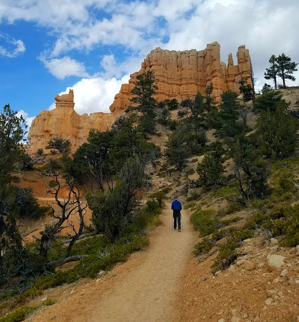
How many hoodoos does it take to make Bryce Canyon National Park? A whole lot! You’ve seen two-dimensional photos, but they don’t prepare you for the reality in 3D. And you get to walk all around in it!
Hikers generally don’t sleep in because we know that morning is the best time to experience the natural world before those pesky (other) humans show up – and in a desert setting it’s best to hike before the temperatures rise. We had our sights set on the Fairyland Loop and its trailhead one mile north of the park’s official entrance. We’d heard that the parking lot fills up quickly in the morning, and if you miss out then you have to park elsewhere and catch a shuttle, making a later start on the trail.
Note: You can also start this hike from Sunset Point, which has a larger parking area, but you have to pass through the Park entrance where everyone else is trying to enter.
So our foursome was out the door very early and circling for a spot. Most folks park, walk out to Fairyland Point, take that selfie, and go back to their cars. Don’t roll your eyes, we’ve all done that in some places and probably will again. Everyone has priorities. All we needed to do was wait just a few minutes. A car departed, we happily parked, grabbed our packs and poles and hit the trail.
Note: The Fairyland Loop Trail starts on the rim of Fairyland Canyon. Hiking clockwise, it goes about 5.5 miles and intersects with the Rim Trail at Sunset Point, which continues another 2.5 miles to complete the loop. The entire hike is about 8 miles, longer if you add on the spur trail to Tower Bridge.
How does Mother Nature make a hoodoo? Weathering and erosion caused by ice and rain. Elevation in Bryce Canyon varies from 6,600 to 9,100 feet and gets above freezing temperatures and below freezing temperatures more than 170 nights during a year.
Somewhere in the first couple of miles we met a group of women about my age, all smiles, on an annual group trip. One saw Jim’s VT hat and said GO HOKIES, demonstrating once again that Virginia Tech folks are everywhere.
Around the same time we passed a young man wearing only shorts and cowboy boots, carrying a very large wooden hiking stick. He had one prosthetic leg and his gait was awkward, but his face bore an expression of intense focus. I had the sense of a profound challenge being met. A young woman accompanied him, neither of them speaking as we passed going in the opposite direction.
The trail descends into Campbell Canyon. At about 4 miles, we turned left onto a .2-mile spur trail to Tower Bridge [a bit of a stretch to imagine a resemblance to the iconic bridge in London, England, but, IMHO, so was Fred Flintstone yesterday at Kodachrome Basin].
Clouds were moving in as we returned to the Fairyland Loop Trail and began a significant (hard) climb back up to the canyon rim (nearly 1,000 feet elevation gain in 1.5 miles). This required increasing our pace, breathing harder, and continuing to marvel at the unfolding scenery.

 The China Wall is another uh-MAZ-ing feature on the Fairyland Loop Trail that photos fail to capture. The name refers to its ridges that remind viewers of the Great Wall of China.
Notice snow in the crevices at the base of the hoodoos.
As we passed the short spur trail to the North Campground on the canyon rim, we crossed paths again with the young man in cowboy boots, looking as though walking was now painful but no less determined to reach the goal he envisioned. I hope he was successful in whatever way was meaningful for him.
The Rim Trail was overflowing with people checking out Sunset Point, and we skirted through as quickly as we could. Still more than two miles to go from there as the Rim Trail passed along the top edge of the Pink Cliffs (remember we saw these from Panorama Point in Kodachrome Basin yesterday?)
After the hike we entered the Park to check out the Visitor Center and store. Staff members were doing their best to limit the number of patrons inside and enforce social distancing. I felt empathetic and appreciative of people whose jobs required them to work with the public during the uncertainties of the pandemic. Was I putting them at risk or helping them to maintain a paycheck? As I write this a year later, very few conclusions.

As I efficiently stamped my National Parks Passport and bought my souvenir patches, I wondered…
will my kids throw my patch collection away when I’m gone?
We headed back to our Airbnb, cleaned ourselves up, and drove further up Highway 14 to Duck Creek Village for dinner. There wasn’t much open at this time of year. I’d thought the Village would be a more sophisticated resort than it was but, nonetheless, Aunt Sue’s Chalet welcomed us as its only customers. They had red and white house wines and beer, including Polygamy Porter by Utah’s own Wasatch Brewery. “When you want more than one!”
The service was fantastic, of course, and the food was very good, especially the blueberry pie.
“Water, water, water....There is no shortage of water in the desert but exactly the right amount, a perfect ratio of water to rock, water to sand, insuring that wide, free, open, generous spacing among plants and animals, homes and towns and cities, which makes the arid West so different from any other part of the nation. There is no lack of water here unless you try to establish a city where no city should be.” ~Edward Abbey


No comments:
Post a Comment