
Pembrokeshire Coast Path Day 10 – Herbrandston to Pembroke –
8/12/19
14 miles, 2100 ft. gain

[If this reads like a diary entry full of personal
details – you’re right! It’s my story. Some info may be helpful for your trip
planning, there’s an abundance of photos because everything was so beautiful,
and I believe food and drink and human connections are the secret sauce of
traveling. As they say, “Take what you need and leave the rest.” Enjoy!]
Reluctant though I was to leave behind the palatial bathroom
at Fields Lodge, Day 10 on the P’shire was ready for us. After a breakfast
every bit as delicious as our charcuterie supper, our host shuttled Danny and
me back to the yacht club to continue our trek. (This was outside of Jayne’s
usual services but she was most gracious to accommodate the request.)


Up the steps and onto the path
Today’s hike was a mixed bag of woods, fields, pavement and more
navigation challenges, with some surprises new to both of us. We began by walking
through the Monday morning residential streets of Milford Haven. Blue skies for
the start of a new day.


Walking directions such as “follow the most obvious route”
were vague, so after we crossed the Victoria Bridge we began to ask folks
on the street for waypoints. The first two couldn’t help us. When an energetic woman out for her morning
exercise approached, Danny asked her for assistance and she kindly stopped. She inquired where we were from, and upon learning that Danny lived in Asheville, NC,
she remarked that she had a sister in Asheville! When she
mentioned the name, Danny put two and two together: she had told an Asheville friend about
her impending trip to Wales, and he said that his sister-in-law Valerie lived in Tenby. Today Valerie was visiting friends in Milford Haven, having a nice walk and unaware of just how small the world was about to get. What’s that about six degrees of separation?


I spy with my little eye an oil refinery across the
waterway
Alongside Hamilton Terrace we were intrigued by Milford
Haven’s War Memorial Gardens, a narrow strip of green with benches, flowers and
statues commemorating the First and Second World Wars. Red impatiens reminded
me of the ubiquitous red poppies of World War One. Danny added to her photo collection of World
War One commemorations.

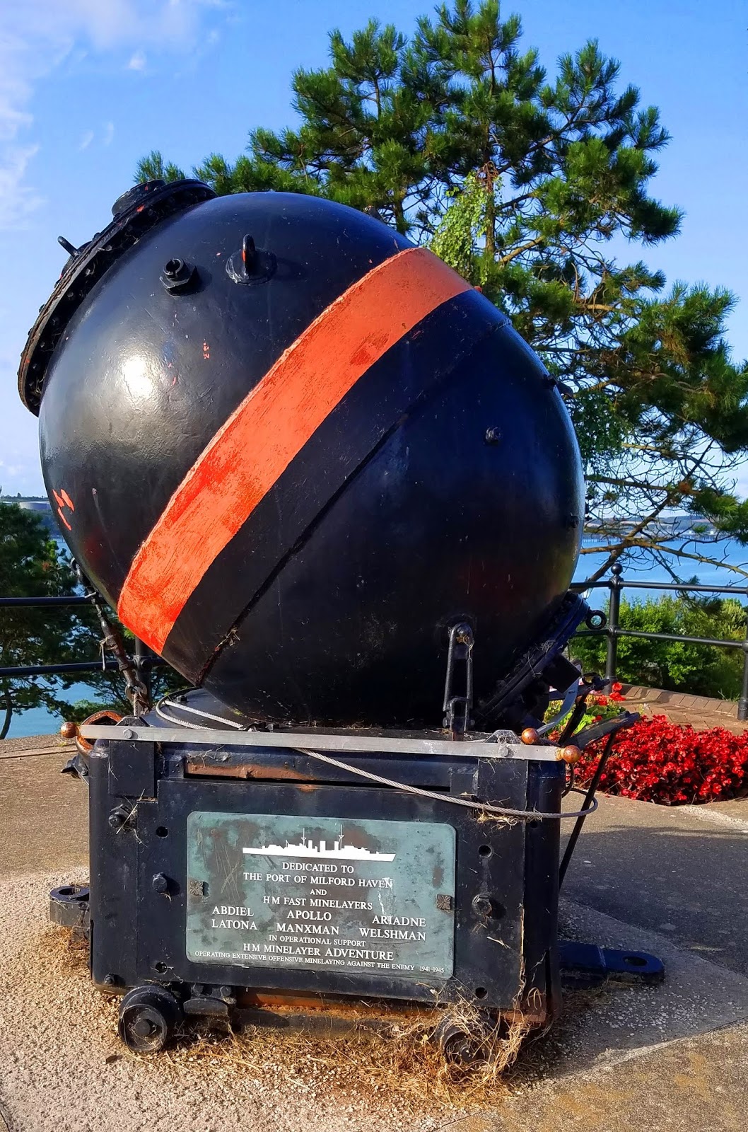
The Sea Mine Memorial is dedicated to the ships and
crew participating in the operational support of the HM minelayer adventure
“operating extensive offensive minelaying
against the enemy” in World War Two.

A real fingerpost
After crossing the Castle Pill via the Black Bridge, we
reached a roadway that the guidebook warned was a “dangerous stretch," fast traffic around a long blind curve and no sidewalk. “If you want to play it
safe, walk uphill through the housing estate.” End of narrative. While I can
appreciate avoiding a long detour around the tidal inlet, even those little
credit-card-sized waymarkers would have been welcome in finding our way through
the housing estate. After a bit of wandering and hesitation we had not solved
the riddle, but we didn’t want to go back to the busy road. Then another
friendly Welshman appeared.

Well, Mr. Rogers always said that in times of trouble
you should look for the helpers:
let’s ask the postman!
When we found our next prominent waypoint, we paused to
regroup. Danny quickly dropped her daypack and proclaimed, “I need a drink!” As
she took a long swallow from her water bottle, I laughed with giddy relief. We
had been so intent on problem-solving that we hadn’t taken a rest break and it
was much needed.

Here we go cross-country toward the waterway, down shady
lanes and alongside small pastures adjoining the LNG tank farm. The P’shire
squeezed between the shoreline and the wire fence that separated us from storage
tanks and windmills.


Near here a pickup truck approached us (on the inside
of the fence) to say hello
and see how we were doing. Security cameras?
How does the product get from the jetties in the waterway to
the storage tanks? Pipelines. The extensive infrastructure built for hikers to
safely navigate across this section is impressive, a maze-like series of steel
cages and tunnel walkways. Exciting stuff! Danny was impressed at the effort to
make the trail accessible, something that she felt would not be attempted in
the U.S.


Danny’s enjoyment of the “amusement park” was my
favorite part of Day 10.
The P’shire emerged onto Hazelbeach (toilets!) and joined
the pavement again, taking us past pretty houses and St. Tudwal’s Church of Llandstadwell
Parish and on to the town of Neyland on the northern shore of the waterway.

The Swan family having a beach day


Geography lesson: The Milford Haven harbour is formed where the Eastern and Western Cleddau rivers combine (the River Cleddau) and flow to the sea. The Welsh name of the combined estuary is the Daugleddau ("the two Cleddaus").
For hours we’d been seeing the massive Cleddau Bridge spanning
the waterway between Neyland and Pembroke Dock. The one-mile bridge between the two towns is an alternative to 28 miles of roadway. It is the route for the A477 road,
the Pembrokeshire Coast Path and National Cycle Network Route 4.
Intimidating and confounding, the P’shire turned us away
from the concrete structure and delivered us to a smaller bridge further upstream that connected to the main bridge span.

Is this our bridge?


Smokestacks to the left of me, tank farm to the
right,
here I am, stuck in the middle with windmills
Safely deposited onto the southern shore, the scavenger hunt
through the busy town of Pembroke Dock commenced, looking for trail stickers
and signposts, risking our lives at roundabouts. The path passed through
Victorian military defenses, quiet residential streets with chickens, and a
half-mile across farmland before arriving at the Mill Bridge and our
destination town of Pembroke and its famous castle.


Irish ferry at Milford Haven Harbour


On the site of Pembroke Castle, a strategic promontory point beside the
Pembroke River, the first structure was built by Earl Roger of Montgomery in 1093. Although attacked numerous times over the centuries, the Norman stone castle
never fell to the Welsh. Most of the present-day castle remains date from the 13th century. It is the largest privately owned castle in Wales (by
the Phillipps family. Read more here and here. This page also includes a wonderful self-guided walk of the town.


We left our backpacks in a storage bin and joined in a
guided tour. An extremely lively and engaging young guide recounted the history
of British castles in Wales, the many times that Pembroke in particular was besieged,
and she described in lurid detail the myriad ways its occupants could defend
entry to the castle (such as pouring a cauldron of boiling hot pee from a
second story window).


As entertaining as our guide was, Danny and I admitted our
own defeat and slipped away mid-tour in search of our accommodations just a
short distance up Main Street.
Woodbine B&B is a lovely Georgian townhouse in the heart
of Pembroke and Andrea is an experienced and thoughtful host. Our comfy room was the most spacious one we’ve had on our
adventure, with a private bath a few steps down the hall. I highly recommend it as a home base in this area of Wales or at least
an overnight experience to walk around the town and enjoy a thorough visit to Pembroke
Castle – and explore the town of Pembroke Docks, too.


Andrea had booked a dinner seating for us at The Coach House,
a bit fancy but very relaxing after our long day. The first time I’d seen Welsh
rarebit on the menu so I had to give it a go – toasted bread with a melted
cheese and Worcestershire sauce. In true eyes-are-bigger-than-my-stomach
fashion, I also tried the delicious spinach and mushroom lasagna, which I couldn’t
finish, but I know I’ll walk it off tomorrow.


Cheers to Day 10 on the Pembrokeshire Coast Path,
full of surprises!
“I say, I wonder what’s going to happen exciting today?”
~Piglet to Winnie-the-Pooh
~Piglet to Winnie-the-Pooh
1 comment:
What an exciting day!
I loved the amusement park aspect to the cages and bridges around the gas plant.
Danny
www.hikertohiker.com
Post a Comment