
Smokies SB6K Backpack – Day Two – 6/9/12 – Balsam
Mountain/ Appalachian Trail/Off-Trail – 12 Miles
I got up once during the night for a nature call and
realized anew what a bad spot my tent was in.
Getting out of the door required crawling uphill, and when I stood up in
the pitch dark I could not get my balance on the slope. Arms pinwheeling, I pitched forward into a
tree branch about neck high, which bounced me backward onto my butt, and then I
rolled downhill back onto my tent. Thank
goodness I didn’t knock it down completely, it just sagged a little (okay, a
lot). After peeing, I crawled back in
and vowed to die there rather than get up again in the dark.
The trail crew guys were up early making noise, which never
bothers me – I enjoy lying in my sleeping bag while other people are up. They left by 7:30 a.m. and I carefully
crawled uphill out of my tent again. Had
to wake Jeff up. We packed our stuff,
ate a little something, and then explored the crew’s base of operations. We had a fun Goldilocks moment sitting
in their chairs in the shelter – tee hee.
Packs on our backs and ready for three more SB6K’s, Jeff was
in front of me as we headed back to Balsam Mountain Trail. As Jeff stepped past, a brownish four-foot
snake popped out from underneath the shelter and began its slinky sideways
approach down the path straight toward me.
I began to yell, “Hey, hey, hey!” which to me meant “Snake, yikes, save
me!” and to Jeff meant absolutely nothing because he didn’t turn around
(perhaps he thought I was singing?) I
stopped on the path and the snake kept coming, until I stepped off to the right
and it slithered off to the left. I
didn’t make note of its markings because I was fascinated by its graceful glide.
In the first half-mile we caught up with the trail crew, taking a quick break from their morning’s work improving Balsam Mountain Trail. With hazel hoes and rakes they had cut deeper into the bank and widened the trail. Ours were the first hiker footsteps on this new improvement.
In the first half-mile we caught up with the trail crew, taking a quick break from their morning’s work improving Balsam Mountain Trail. With hazel hoes and rakes they had cut deeper into the bank and widened the trail. Ours were the first hiker footsteps on this new improvement.

Balsam Mountain Trail is one of the best trails in the park
that few people ever see. From Laurel
Gap the trail takes a distinct left turn and runs along the ridge of Balsam
Mountain, acting as the horizontal bar of the letter “H” connecting the Mount
Sterling ridge on one side and the AT ridge on the other. It’s an easy trail to walk on, not much
change in elevation, with glimpses into the valleys on either side. The trail character alternates between
hardwoods and alpine forest, rocks and roots and lush green ferns.

Peaking through (notice the dark cloud looming above?)


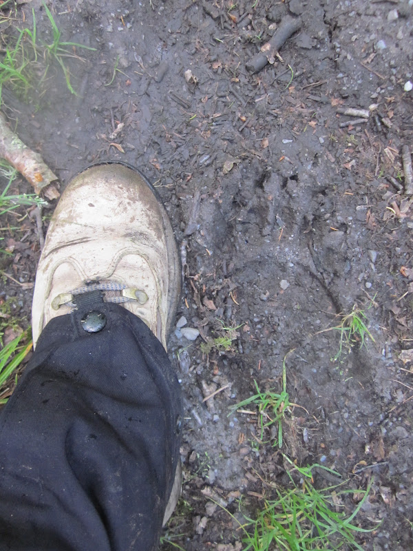
Bear print – we saw several of these, always headed in the
opposite direction – I guess Mr. Bear was here yesterday?

Dropping our packs to climb Luftee Knob
Although not a picnic, bush- whacking up to the summit of
Luftee Knob was not as difficult as Big Cataloochee yesterday. In retrospect, Big Cat was an excellent first
experience to measure the other summits against. I didn’t like it, I was exhausted by it, but
I survived it and felt that elation of accomplishment. I continually asked Jeff for a ranking of all
the other summits and a comparison to Big Cat.
Why? I was going to do them no
matter what. But with any endeavor the
challenge is mostly mental, and it helped me to get psyched (or resigned) to
whatever was coming up. Luftee Knob was
a .6-mile round trip, less steep but just as gnarly with lush undergrowth and
downed tree obstacles. There was
nothing to indicate the summit other than Jeff’s GPS said so.
A couple of miles further along Balsam Mountain Trail we
reached our next challenge, two summits originating from the same location on
the trail, one to the right and the other to the left. First, Mt. Yonaguska, which Jeff had not
summited. (Those funny SB6K guidelines say that either Mt. Yonaguska or
Tricorner Knob can count because they are the same height and are considered
spurs of each other – Jeff has bagged Tricorner Knob.) So up we went, the shortest trip yet at .25
miles each way and Jeff creating a GPS track, to this scenic spot on top of Mt.
Yonaguska.

(And how do you pronounce that? Yon-uh-GOO-skuh. Say it out loud now. Nobody is listening.)

Coming back down, Jeff says “Follow me.”

And I’m trying.
A little rest and something to eat while Jeff explains our
next summit to Mark’s Knob. This is 1.1
miles one way, which I equate to multiple hours based on what we’ve experienced
so far. But…this used to be a maintained
trail (decommissioned how many years ago?) going around Mt. Hardison and Mark's Knob and over to Hyatt Ridge Trail (which now dead ends at Campsite 44) and it’s relatively level, not much
elevation gain until the final push, and discernible where trail builders cut
the trail out of the mountainside and leveled it (just like the trail crew was
doing when we passed them this morning – go back and look at that photo). AND several people had put up flagging tape
the whole way. I was thrilled.

Summit of Mark’s Knob

New growth on balsam branches
One rather significant detail – unmaintained means crews no longer clear
the deadfall on the trail. We were constantly stepping over, ducking
under or climbing over trees of all sizes.
On the return leg we counted about 350 trees across the trail. Yes, that means that out-and-back, 2.2 miles,
we had over 700 trees to negotiate around. Yet
this was my favorite summit because of little elevation gain and a marked path
so I could find my own way.

On the return, Jeff took the time to also summit Mt.
Hardison (the “trail” skirted around the summit), adding to his long list of
bagged peaks and making his time a little more worthwhile. He still arrived back at our meeting point on
Balsam Mountain Trail shortly after I did; he can move much faster when I’m not
whining along behind.
And hey, look, it’s still early. Maybe we can make one more peak today? Mt. Chapman is beckoning.
One more mile and we reached the end of Balsam Mountain
Trail and our home for the night, Tricorner Knob Shelter. We’ve stayed here before, know that the
shelter sits on a very narrow ledge and there isn’t much room to pitch tents if
the shelter scene is less than fun. As we
walked down to the shelter Jeff pointed out a camping spot to the right of the
trail, sitting high up on the ridge.
Perhaps we’ll end up there? But
let’s see what’s going on at the shelter first.
Five backpackers were sprawled out in the shelter,
20-somethings from Texas who were hiking the Smokies section of the AT. Their first question was did I bring any
beer? (I didn’t even need to look at
Jeff for his opinion.) We chatted with
the young’uns for a few minutes, didn’t get any warm and fuzzy feelings, and
then we left to conquer Mt. Chapman.
Mt. Chapman is an SB6K mountain about a mile south of
Tricorner Knob on the AT. Then it’s a
short bushwhack (.2 miles one way) but quite steep. I was running out of gas by now and even a
little elevation had me breathing hard.

Dead balsam on Mt. Chapman - unusual bleached effect

Yellow bead lilies were so numerous we couldn’t avoid
walking on them (aka blue bead lilies when the blooms fade and it bears dark blue
fruit).

View of Mt. Guyot – shuddering chills and ominous music –
one of tomorrow’s goals and the worst one of all (and those clouds hovered all day but no rain)

Summit of Mt. Chapman – four SB6K’s in one day!
On the way back to Tricorner Knob Shelter, we discussed our sleeping options. The
Texas folks didn’t have reservations, so it was possible that the shelter could
get a lot more crowded. As we talked, we
came up behind a young couple with loaded backpacks who was also headed for
Tricorner (without reservations).
They wondered what we were doing, hiking around up on the AT without any
gear at all (we had left everything at the shelter for this short side
trip).
That settled it for Jeff – he was going to check out the little
campsite and relocate. I
wasn’t thrilled because rain was on the way and I did not want to take down a
wet tent in the morning. But it seemed a
more peaceful option than staying in the shelter.
Again…oh ye of little faith!
The five Texans had discovered the campsite and moved in themselves!
If we’d had a webcam set up, the next few hours would show the weary young couple from the AT arriving and spreading out their gear, several more hikers showing up, investigating the layout, choosing hidden spots in the woods behind the latrines to hang hammocks or set up tents, and various forms of food prep, including one guy who didn’t like to carry a stove (minimalist) but was not shy about asking for any hot water anyone had left over (yes, I let him use my stove). One of the Texas girls came back to get her hiking stick, which was leaning against the wall and I had mistaken for a random stick and had hung my sports bra on to dry (sorry about that).
If we’d had a webcam set up, the next few hours would show the weary young couple from the AT arriving and spreading out their gear, several more hikers showing up, investigating the layout, choosing hidden spots in the woods behind the latrines to hang hammocks or set up tents, and various forms of food prep, including one guy who didn’t like to carry a stove (minimalist) but was not shy about asking for any hot water anyone had left over (yes, I let him use my stove). One of the Texas girls came back to get her hiking stick, which was leaning against the wall and I had mistaken for a random stick and had hung my sports bra on to dry (sorry about that).

We ended up having a very pleasant evening, just Jeff and
me and the backpacking couple staying in the shelter, talking about past hikes and future plans. A goosebumpy feeling, the farthest point away from a road in all of the Smokies, sitting high up on a mountain as the light faded. Slept well.
"Keep close to nature's heart, yourself; and break clear
away, once in a while, and climb a mountain or spend a week in the woods. Wash
your spirit clean." ~John Muir
3 comments:
Hi Sharon, this is your namesake, Sharon!! Don't know why I chose today to leave a comment, but must confess I'm a long-time stalker of your blog. In fact, I've read it from the very beginning absolutely loving your posts when you were doing all the trails. I still search for your original narrative when I'm getting ready to do a trail for the first time. Perhaps, it was the snake story today since you've shattered my illusion that there are no snakes above 5,000 feet! (LOL!) Perhaps it was the picture contrived in my mind of you dancing around outside your tent in the dark! Not sure, but for whatever reason, know that I love all your posts and always gets excited when one pops up in my reader!! One of these days, hope you'll decide to mark your second map in the Smokies!
Wow great job conquering three summits in day! Yep, my last hike did not leave me any warm any fuzzy feelings about bushwacking through long un-maintained trails..
So glad you all are enjoying the blog, just wish I could stay more current (I'm about 5 hikes behind right now.) I try to keep good notes and include most everything, just holding back some stories to protect the innocent (or sometimes guilty). I tell the stories on myself to keep me humble. Every time I go into the woods and come out okay I am grateful, knowing that it's partly skill, partly luck and mostly grace. AND...I am marking a second Smokies map.
Post a Comment