
2/1/09 – Lower Mt. Cammerer Trail/AT/Mt. Cammerer Trail out-and-back/AT/Low Gap II Trail/ and all the campground connector trails – 17.2 Miles
Today was a hike much anticipated and the weather was cooperating in a big way. Now that the days are a teensy bit longer, Judy and I chose to meet at 8:30 a.m. at the Cosby Campground since she was driv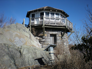 ing 90 minutes from her home in Fletcher, NC. Our planned route (Hike #2 in the Big Creek/ Cosby section of "Day Hiker's Guide") was about 15.7 miles so we could easily be done by 5:00 p.m. (Well, we put in a little more mileage than that, but we still finished by 5:00!) Looking at the elevation profiles and reading the trail descriptions, today was going to be a challenge, but the payoff was a big one – Mount Cammerer Lookout Tower.
But first we had to get there. From the hiker parking area we walked .4 miles on Low Gap II Trail through a fairy land of moss, boulders, bridges and flowing creeks that I can’t name (Cosby Creek?), and then we turned left onto Lower Mount Cammerer Trail. One of the best trail descriptions I have ever read is from “Hiking Trails of the Smokies”: “Imagine a giant cupcake plopped upside down. To hike around it, you need to go in and out of all those hills and valleys of the cupcake paper. The Lower Mt. Cammerer Trail dips in and out of creek valleys as it swings half way around Mount Cammerer to connect Cosby Campground with the Appalachian trail...” Isn’t that a fantastic visual image?
Temperatures were in the high 20’s as we started off and the frozen mud crunched under our feet. One particular hillside was covered in long frozen curls and we took entirely too many photos trying to capture the feeling. Before the day was over we would be hiking in sh ort sleeves and squishing as the mud thawed. At about 1.5 miles we walked up the side trail to the Sutton Ridge overlook for this view to the northwest. I imagine it is fantastic during fall leaf season.
We paused at Campsite 35 for a little snack and then the trail began to rise more purposefully. At a gap that looked like a prime site for camping we actually discovered a cemetery with just a few graves, one of which had an engraved stone for a two-year-old boy. There is no mention of this site in the “brown book.” Later o n I bought a book titled “History Hikes of the Smokies” and read that this place is called Turkey Knob and the cemetery is Phillips Cemetery. In cross-referencing sources for cemetery information, I am beginning to see that this is the tip of the iceberg and I am intrigued. I believe that the cemeteries were meant to be private, but I feel drawn to them and feel compelled to stop and pay my respects.
All along Lower Mount Cammerer Trail we rounded corners, stepped across seeps and admired icicles hanging from the rocks. Jud y remarked how gentle this trail was compared to the AT. Here you can see by Judy’s foot how thick some of these icicles were.
A couple of miles later we reached the junction with the Appalachian Trail. This 2.3-mile section up to the Mount Cammerer Trail may as well have a sign that says, “Serious Hiking Ahead – No Whining,” a rule I would have br oken. This section kicked my butt! It is steep and eroded and “improved” with steps for horses, I suppose, since the steps don’t match a human’s stride at all. The aura of the AT is still there and it definitely has a different feel than other trails in the Park. The temperature rose and I stopped to remove my long underwear. I stopped again to eat something. I stopped once or twice to wipe tears from my face and suck it up. Man, what a long 2.3 miles! Judy just smiled and kept going.
 After an eternity we turned right onto Mount Cammerer Trail, the real deal. The anticipation mounted until we finally rounded the last bend and the lookout popped into view. Magnificent! I read somewhere (but can’t cite it now) that the difference between a tower and a lookout
 is that a lookout is affixed to the ground and is only two stories tall, while a tower is much taller. Anyway, the original lookout was completed in 1939 by the CCC using local stone quarried and cut on-site by masons and timber cut near the site. It deteriorated after the 1960’s when more modern methods of fire detection were adopted, but in 1996 it was rebuilt. Judy and I had the place to ourselves and
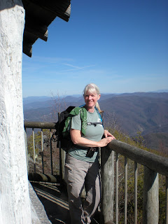
  explored, climbing on the rocks, walking all around the catwalk and signing the notebook inside. We even ate lunch sitting out on the catwalk, looking east towards Max Patch and Jane Bald. This photo is of Mount Sterling through the catwalk railings. A clear blue, faultless, God-given day…
Eventually we said goodbye and walked back out to the AT and down to the Low Gap II Trail junction, which led back down towards Cosby Campground. There is nothing to recommend this trail except that it is the shortest way to get to Mount Cammerer. In fact, it’s pretty steep and rocky and my thighs were burning and my knees were creaking by the time we reached the bottom. Now, a word about our mileage: there are many connector trails from the camp ground to the hiking trails. Judy and I decided that since we were here and the time wasn’t too late, we should just knock them all out, so we ran around like rats in a maze to be sure we had covered all the spurs. There is lots of water here (Cosby Creek again, I guess?) and so it’s a pretty setting and fun to explore if you are camping here. Here is one particularly nice cascade on Low Gap Trail very close to the campground.
Time once again for the long drive back home. We waved goodbye and I put in my CD’s to sing along. I wonder when I’ll finally just move here?
Today was a hike much anticipated and the weather was cooperating in a big way. Now that the days are a teensy bit longer, Judy and I chose to meet at 8:30 a.m. at the Cosby Campground since she was driv
 ing 90 minutes from her home in Fletcher, NC. Our planned route (Hike #2 in the Big Creek/ Cosby section of "Day Hiker's Guide") was about 15.7 miles so we could easily be done by 5:00 p.m. (Well, we put in a little more mileage than that, but we still finished by 5:00!) Looking at the elevation profiles and reading the trail descriptions, today was going to be a challenge, but the payoff was a big one – Mount Cammerer Lookout Tower.
But first we had to get there. From the hiker parking area we walked .4 miles on Low Gap II Trail through a fairy land of moss, boulders, bridges and flowing creeks that I can’t name (Cosby Creek?), and then we turned left onto Lower Mount Cammerer Trail. One of the best trail descriptions I have ever read is from “Hiking Trails of the Smokies”: “Imagine a giant cupcake plopped upside down. To hike around it, you need to go in and out of all those hills and valleys of the cupcake paper. The Lower Mt. Cammerer Trail dips in and out of creek valleys as it swings half way around Mount Cammerer to connect Cosby Campground with the Appalachian trail...” Isn’t that a fantastic visual image?
Temperatures were in the high 20’s as we started off and the frozen mud crunched under our feet. One particular hillside was covered in long frozen curls and we took entirely too many photos trying to capture the feeling. Before the day was over we would be hiking in sh
 ort sleeves and squishing as the mud thawed. At about 1.5 miles we walked up the side trail to the Sutton Ridge overlook for this view to the northwest. I imagine it is fantastic during fall leaf season.
We paused at Campsite 35 for a little snack and then the trail began to rise more purposefully. At a gap that looked like a prime site for camping we actually discovered a cemetery with just a few graves, one of which had an engraved stone for a two-year-old boy. There is no mention of this site in the “brown book.” Later o
 n I bought a book titled “History Hikes of the Smokies” and read that this place is called Turkey Knob and the cemetery is Phillips Cemetery. In cross-referencing sources for cemetery information, I am beginning to see that this is the tip of the iceberg and I am intrigued. I believe that the cemeteries were meant to be private, but I feel drawn to them and feel compelled to stop and pay my respects.
All along Lower Mount Cammerer Trail we rounded corners, stepped across seeps and admired icicles hanging from the rocks. Jud
 y remarked how gentle this trail was compared to the AT. Here you can see by Judy’s foot how thick some of these icicles were.
A couple of miles later we reached the junction with the Appalachian Trail. This 2.3-mile section up to the Mount Cammerer Trail may as well have a sign that says, “Serious Hiking Ahead – No Whining,” a rule I would have br
 oken. This section kicked my butt! It is steep and eroded and “improved” with steps for horses, I suppose, since the steps don’t match a human’s stride at all. The aura of the AT is still there and it definitely has a different feel than other trails in the Park. The temperature rose and I stopped to remove my long underwear. I stopped again to eat something. I stopped once or twice to wipe tears from my face and suck it up. Man, what a long 2.3 miles! Judy just smiled and kept going.
 After an eternity we turned right onto Mount Cammerer Trail, the real deal. The anticipation mounted until we finally rounded the last bend and the lookout popped into view. Magnificent! I read somewhere (but can’t cite it now) that the difference between a tower and a lookout
 is that a lookout is affixed to the ground and is only two stories tall, while a tower is much taller. Anyway, the original lookout was completed in 1939 by the CCC using local stone quarried and cut on-site by masons and timber cut near the site. It deteriorated after the 1960’s when more modern methods of fire detection were adopted, but in 1996 it was rebuilt. Judy and I had the place to ourselves and
  explored, climbing on the rocks, walking all around the catwalk and signing the notebook inside. We even ate lunch sitting out on the catwalk, looking east towards Max Patch and Jane Bald. This photo is of Mount Sterling through the catwalk railings. A clear blue, faultless, God-given day…
Eventually we said goodbye and walked back out to the AT and down to the Low Gap II Trail junction, which led back down towards Cosby Campground. There is nothing to recommend this trail except that it is the shortest way to get to Mount Cammerer. In fact, it’s pretty steep and rocky and my thighs were burning and my knees were creaking by the time we reached the bottom. Now, a word about our mileage: there are many connector trails from the camp
 ground to the hiking trails. Judy and I decided that since we were here and the time wasn’t too late, we should just knock them all out, so we ran around like rats in a maze to be sure we had covered all the spurs. There is lots of water here (Cosby Creek again, I guess?) and so it’s a pretty setting and fun to explore if you are camping here. Here is one particularly nice cascade on Low Gap Trail very close to the campground.
Time once again for the long drive back home. We waved goodbye and I put in my CD’s to sing along. I wonder when I’ll finally just move here?


 Back at the hostel, Bob and Daniel had stoked the stove all day and our home-away-from-home was a wonderful 45 degrees. We all managed to prepare and devour a potluck supper and enjoyed each other’s company. What a great group of people! Everyone was flexible, found the humor in the circumstances, and knew that we were sharing a special experience that we would always remember. Since the kitchen pipes were frozen, dishes were washed in the bathroom shower and sink. That night when we crawled into sleeping bags, we talked and laughed well into the night, and promised never to confess what the jokes were about.