Monday, June 21, 2021

Mount Mitchell State Park: Maple Camp Bald Loop

Mount Mitchell State Park – Maple Camp Bald Loop – 7/17/20 – 8.3 miles


Browsing my shelf of hiking guidebooks for a training hike for my upcoming John Muir Trail adventure, Danny Bernstein's stellar Hiking North Carolina's Blue Ridge Mountains offered up a loop hike in Mount Mitchell State Park. I wanted something interesting, physically challenging, and within a reasonable distance from home. As Meatloaf famously sang, "Two out of three ain't bad."

Jim tagged along, good sport that he is, to help me with the six-hour roundtrip drive and for safety on the hike. The terrain in Mount Mitchell NP is no joke, and weather can change rapidly and more severely than in many places that I'm comfortable hiking solo. Plus I enjoy having him around.

We opted to tackle the loop going clockwise, in the opposite direction of Danny’s narrative, to hike on the ridgeline first and avoid two things: more people later in the day and exposure to possible afternoon thunderstorms.


From the parking lot, Deep Gap Trail leads through the picnic area and into a Hansel and Gretel alpine forest, misty and cool, with secret moss-covered places for storybook creatures to hide. I’m sure we added an hour to this hike just by taking photos.

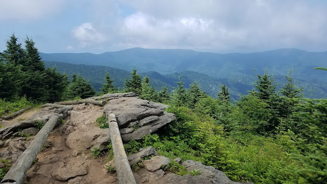
The view from the top of Mount Craig - 6,650 feet

Deep Gap Trail continues its ramble eastward along the ridgeline, an ever-so-slight downhill to the summit of Big Tom at 6,580 feet. These two peaks and several more 6,000 footers are lined up along the Black Mountain Crest. I’ve hiked them before as part of the South Beyond 6000 Challenge.


Michaux’s saxifrage growing in mossy spots

I remembered that the trail was rugged, yet I was still surprised by the big boulders and roots and intimidated by the ropes set in place for ascending and descending Big Tom’s slippery rock faces. 


Looking back up at what we just scrambled down

We turned right off of Deep Gap Trail, plunging steeply downhill on Big Tom Gap Trail (#191-A), which sees far less foot traffic. It was narrow, poorly marked, and alternated between piles of rocks and overgrown tall grass such that we couldn’t see our footing.  Jim was especially good at stepping into holes and yelping. This trail wasn’t long but it was ornery.

At the intersection with Buncombe Horse Trail we paused for a snack break, then turned left to follow Danny's directions to Maple Camp Bald. This trail was even less traveled, and since we were following the route in a different direction and weren’t checking mileage, it was challenging to determine when we had reached our destination. The vegetation was nearly chest high, which afforded the opportunity to enjoy the profusion of yellow flowers.

St. John’s Wort

Whorled loosestrife

Southern bush honeysuckle


Looking across the South Toe River valley towards the Blacks – are they on fire?
No, but those gathering clouds got our attention.


We arrived at a campsite with a nice view – could this be Maple Camp Bald? The “bald” is very broad and we couldn’t find a summit marker. We kept going for a bit, then turned back,
figuring we had done our best.

Buncombe Horse Trail was wide and very flat, rocky as to be expected, and required paying attention to navigate muddy spots. At this level of alpine elevation, the temperature was cool and comfortable (unlike our home in Charlotte, sweltering in the 90-plus degree heat).  Those dark clouds were concerning, and persistent thunder rumbled for the couple of hours we were on this trail, but they didn’t produce any wind or rain. (On our drive home we saw evidence of lots of rain in the valley.)

Galax

Surprise of the day – one purple fringed orchid

We stopped for a quick lunch at a campsite near the junction of the Buncombe Horse Trail and the Mountains-To-Sea Trail. With less than two miles to go, it was tempting to just keep pushing, but I’m glad we stopped to eat and rest. We had a big job ahead of us climbing up Mount Mitchell.

The MST runs concurrently with Mount Mitchell Trail and I’ve hiked this section several times, both up and down. It is seriously steep, unforgiving terrain, with encouraging (or discouraging) signposts of elevation progress (ex. 5900, 6250, etc.) It is a mental challenge as well as a physical one. The best advice I have is to go at your own pace. In total, the trail is about an 800-foot elevation gain in 1.6 miles, and Jim and I completed it in exactly one hour.

As we neared the parking area, we met the flow of people just getting onto the trails. It was a good decision to hike clockwise for more solitude. [We saw only five hikers on Deep Gap Trail and no one else until those folks near the end of the loop.] It was just good luck that thunderstorms never developed while we on the trail.

We stopped at a little brewery in the town of Marion to see if they were COVID-friendly (yes). Jim loves trying local beers and I’m happy that most places now offer ciders too. Mica Brewing had one of my favorites from Wisconsin on tap: Ciderboys Peach County! We toasted Danny’s contributions to the hiking world and another safe, magical day in the North Carolina mountains.

“The world is big and I want to have
a good look at it before it gets dark.”
~John Muir


Sunday, June 13, 2021

Carolina Thread Trail: Murray's Mill & Bunker Hill Covered Bridge

Carolina Thread Trail: Murray’s Mill & Bunker Hill Covered Bridge – Catawba, NC
7/4/20 – 4.5 Miles

Travel plans canceled left and right as the world realized that COVID-19 was not going anywhere fast. Beach trips, mountain vacations, Disney World, and visits to Grandma’s, everything seemed risky. 

Canceling the annual 4th of July Thomas family reunion of my mother’s generation (16 siblings!) and descendants was especially disappointing, as folks are scattered far across the land with just this once-a-year chance to see elders, cousins and new babies. There were so many of us, I didn’t know them all. In 2020, no reunion, no Virginia accents, no talk of farming (tobacco has been replaced by hemp!) and…oh, the food! Let’s pause a moment for the food.

Jim and I were itching to do something, wear our masks and be outside somewhere new in the 93-degree heat. He’s mentioned Murray’s Mill a few times as a day outing, so this was our chance. Even if the mill wasn’t open, there is a segment of the Carolina Thread trail to walk on. So we took a little drive to Catawba, NC. A calendar-perfect day for photographing the mill!

Murray’s Mill Lake formed by damming of Balls Creek

The David L. Stewart Trail starts beyond the mill and continues between the edge of Murray’s Mill Lake and a soybean field. Wild blackberries were bursting beside the path. The air was July-still and the mid-day sun produced a stifling heat. 


When I was a kid, the Thomas reunion was held in my own family’s big side yard. Imagine over 100 people, lots of barefoot children, lawn chairs, ice cream churns, and that same July heat. We weren’t allowed in our little house except to use the bathroom. The moms would hustle all the food out onto borrowed picnic tables when it was time to eat and hustle the leftovers back inside when the meal was over. Those who came from out of town left for the drive back home, and the locals stayed around until suppertime, when the moms brought the leftovers back out to the tables.  When I was an adult with kids of my own, our elders finally agreed to move the event to an air-conditioned church basement.

Jim and I followed the trail looking for snakes and other critters, but none were stirring. The wooded area was a respite from the direct sun. 

The trail comes to the edge of Shiloh United Methodist Church’s parking lot, turns right, then skirts the property edge out to Shiloh Road where it crosses Balls Creek. From here, the Murray’s Mill Pond Loop Trail continues to the opposite side of the pond and back to the Mill.

…but we turned back the way we came and retraced our steps to the mill.

Another section of the trail starts at the mill and goes in the other direction, but Carolina Thread Trail signs didn’t continue as far as the website suggests. The path still follows the creek, but it divides and re-divides into social trails and motorbike trails.

Trail passes under the bridge by the mill 

A footbridge crossing Balls Creek had been damaged by high water. It wasn’t broken down entirely and we treaded lightly to see what was on the other side. Many trails intersected without signage, so we headed back once again to the mill.

Inside the little general store was busy and uncomfortable as some people wore masks and some didn’t (still voluntary at this time).  But most importantly, the A/C worked and there were goodies.


Not knowing if there would be any food available anywhere, we’d brought our own sandwiches, and now our picnic was complete with a Nehi Peach and a Sun Drop. We ate lunch at a picnic table, not bad at all when you sat a spell in the shade of the old oak trees – just like at a Thomas Family Reunion.

A short drive away from Murray’s Mill, also in Catawba County, is the Bunker Hill Covered Bridge. Built in 1895, it is one of two remaining covered bridges in North Carolina.

The bridge is part of Connor Park, a nice little picnic area with a nature trail. The Bunker Hill Covered Bridge is a short walk from the parking area. We had the place to ourselves as we examined the bridge from all angles, inside and outside and below. It spans Lyle Creek.

The Carolina Thread Trail segment here follows Lyle Creek upstream for about half a mile to end at private property signs. The path was overgrown and humid and buggy…and what else would you expect on the 4th of July! 

The vision of the CTT goes beyond today and I’m glad that the organization grabs every piece of land possible to incorporate into its master plan. Who knows what this little bit of trail will connect to one day? The next generations will enjoy the benefits.

I hope that all of our 4th of July celebrations will return in 2021. I miss that fried chicken and biscuits and chocolate chess pie and butterbeans and cornbread and squash casserole and home grown tomatoes…

“Family is a link to our past,
a bridge to our future.”
~Alex Haley