Sunday, June 29, 2014

The Cascades Waterfall - Go Hokies!


The Cascades With My Daughter, Pembroke, VA – 4/13/14 – 4 miles

An Appalachian Trail hike on Friday, the Virginia Tech 5K with my husband and my daughter on Saturday, and a wonderful Sunday to wrap up my birthday weekend:  a hike with Laura to the Cascades. 

A half-hour drive west of Blacksburg, VA, the Cascades Recreation Area is part of Jefferson National Forest.  It is a very popular picnic area, has a native trout stream, and its star feature is The Cascades, a 69-foot waterfall with a massive plunge pool.  A $3 fee per vehicle is required for this day use area. 

The hike to the falls is an easy-to-moderate 4 mile round trip with a couple of uphills requiring a bit more effort.  A trail map can be downloaded here.  There is also a map board at the parking area but I didn’t see a place to pick up a paper map, so bring your own.   A short distance from the parking lot the trail splits and Laura and I crossed Little Stony Creek on a tall wooden bridge to take the Creekside Trail. 

Little Stony Creek is one of the most beautiful creeks I’ve ever seen, robust with dozens of miniatures cascades and spillways, bubbling at every bend with very few calm spaces.  Since I’m not a good water photographer, I didn’t waste much time trying to capture the flow, just enjoyed the surprises with every step. 

This boiler was used to power a sawmill when the area was heavily logged in the 1920’s and 1930’s.   Aparently Sarah and Noel were here two days ago.  Why do people feel the need to leave their names on things in public spaces?

Following Laura up the trail

Wildflowers emerging:  Dutchman’s breeches

Bloodroot

Coltsfoot

Hepatica

The trail climbs more steeply on masterfully built stone steps, winding in and out of boulders very close to the creek.  At about one mile we crossed Little Stony Creek again on a second wooden bridge.

Laura peeking around a boulder

As we closed in on the second mile, we were teased by the sound of the waterfall long before we could see it.  The Creekside Trail joined the Woodland Trail as we carefully picked our way around more boulders.

And then there it was:  The Cascades


On this chilly day we had no inclination to soak our feet in the water, but during hot weather this is a busy swimming hole.  There were a couple dozen folks there so we all took turns for our photo ops.  A set of steps and a wooden railing climbs up around the left side of the basin to get closer to the top of the falls, although not too close.  

We chose the Woodland Trail for our return to the parking area, an easier grade and a wider track.  The attraction for this trail is the perspective looking down on Little Stony Creek.  Laura and I enjoyed a lovely mother-daughter walk in the woods before we headed our separate ways, me back to Charlotte and her to the great city of Baltimore.  What a gift to get to spend time with her!

Check out this website to see photos and read a story hiking to the frozen Cascades in wintertime.  This is on my list for someday!

Hiking to the Cascades is an activity that nearly every Virginia Tech student experiences during his/her time in Blacksburg.  This link is an inspiring YouTube video of Hokies who made the trip possible for a paraplegic student/friend. This 3:30 video will absolutely make your day!

Ut Prosim:  That I May Serve  ~Virginia Tech motto

Thursday, June 26, 2014

AT Project in VA: Craig Creek Road To A Dead Battery


Appalachian Trail Project in VA – 4/11/14 – Craig Creek Road Northbound to VA 620 - 7.3 Miles

On April 11, 2013 I embarked on a new hiking challenge, to complete the Appalachian Trail section in my home state of Virginia, about 550 miles, for my 55th birthday.  One year later, after an exceptionally tough winter, I am short of my goal but still plugging away.  Today I got on the trail for my 56th birthday, and what could possibly go wrong?

Clue #1:  Why do a simple section when finding a remote trailhead is more fun?  Jim and I drove up from North Carolina, taking 3+ hours to find and drop my car at the hike’s ending point, and I had aspirations of completing the 7.3 miles quickly and driving to a second short section for an out-and-back while Jim enjoyed a long bike ride.  Setting up the route was more involved than it looked on paper, but by late morning I was headed northbound. 

Anticipating today’s unique feature on the trail

After a half-mile crossing multiple footbridges over small creeks that fed into Craig Creek, I began the big climb up Brush Mountain (yes, another one).  Little yellow trout lilies were my first signs of spring on the trail.  I was feeling fine and fresh, switchbacking smoothly, looking for more spring flowers. 

Clue #2:  What I saw was smoke in the valley.  I was not compass oriented.  Is this due northeast, the direction I’m heading?  Is it south?  Is it a controlled burn?  A rampant campfire?  Do I need to think about this some more?  With each switchback the smoky cloud expanded.  Eventually the trail wound around to the other side of the mountain and the suspicious smoke was gone from view.  [Postscript: a controlled burn that I didn't get close to.]

Dog hobble, a shrub, was blooming profusely

Hepatica


At the crest of Brush Mountain the trail turned left and widened to a broad, dull road bed.  After more than a half-mile the reason for the broad access track appeared:  the Audi Murphy Monument.  Murphy was the most decorated American combat soldier of World War II and went on to become an accomplished film actor.  He died in a plane crash on this mountain in 1971.  His body is interred at Arlington Cemetery and is the second most visited site there – the first is the grave of John F. Kennedy.

The memorial stone

Visitors leave stones, patches and other mementos

From the monument, the AT continues north on a gentle slope and then descends more deliberately toward VA 620, the gravel road where my car was waiting for me.  The day was warm and slightly breezy and I was still feeling light on my feet. The downhill was steep enough to jog/trot and I finished the entire 7.3-mile section in about 2 hours 40 minutes.  Plenty of time to do another short section!

At VA 620 I saw a thru-hiker sitting on a big rock, chatting with a retired-looking couple out walking their dog.  After a few minutes of shared conversation the man and woman continued on their way while the hiker and I exchanged a bit more information.  He was German, used the trail name Farmer, wanted to know what I could share about the trail coming up, places to camp and where to resupply.  I told him to be sure and stop to eat at the Homeplace Restaurant in Catawba if possible.  (That’s where Jim and I are headed for supper tonight – all you can eat!)

As Farmer walked on up the trail, I went to my car, unlocked it, loaded up my backpack and…

Clue #3:  my car battery was dead.  Well, I guess that means I’m not doing any more hiking on the trail today, although I’m going to be doing some fast moving. 

I started trotting after the retired couple, obviously local.  When I caught them I explained my dilemma and asked for help.  Sure!  Introductions all around, Curtis and Diane and their dog Buttercup.  I walked with them the rest of the way to their home.  They lived at the intersection of VA 620 and Craig Creek Road, a very unique property, lovely landscaping, multiple outdoor seating arrangements to focus on Craig Creek flowing past their back yard. There was a life-size stone gorilla protruding from as though breaking through the stone façade.  Curtis is a Vietnam veteran, now retired from a 40+-year career in San Francisco, returned back to his roots.  Diane is his second wife, a feisty woman with short cropped hair dyed purplish blue and an incredibly detailed tattoo on her leg of her African grey parrot.  What great good fortune for me to be rescued by such kind people!

Curtis and Diane with Buttercup and Oliver (Butter- cup’s brother)

After a short visit and a tall glass of water, Curtis drove me back to my car and we jump started her back up.  [Learned later that the sensor for detecting an open door was broken, so it did not sound its normal alarm when I opened the door and still had lights turned on or keys in ignition, etc.] Curtis followed me back to the paved road and waved goodbye.  I was not at all stressed at missing the rest of my hike plan.  Meeting my trail angels was the true highlight of my day.

From there I headed to our pre-arranged meeting point, the hiker parking area for McAfee Knob on VA 311, jam packed with cars and casual “hikers” wearing flip-flops and less than half carrying water bottles.  I was very glad I wasn’t hiking to the Knob today.  Do I sound like a hiking snob?  So be it.  Be prepared, people.

Jim arrived soon after, looking very hot and tired (yet exhilarated) from his 48-mile bike ride with a very strenuous climb at the end.  We changed clothes at the car (when you are that hot and sweaty and dirty, you don’t care who sees what).   Then the real reason for hiking and biking these sections:  The Homeplace.  We had both missed lunch so were ravenous for supper.  Not much conversation as we plowed into fried chicken, country ham, butterbeans, corn, mashed potatoes, cole slaw and cobbler.  Don’t forget the sweet iced tea. 

Tomorrow morning Jim and our daughter Laura and I will run in the Virginia Tech "Run In Remembrance" Memorial 5K.  Life is good.

“How old would you be if you didn’t know how old you are?”  ~Satchel Paige


“Because time itself is like a spiral, something special happens on your birthday each year: The same energy that God invested in you at birth is present once again.”  ~Menachem Mendel Schneerson


“The great thing about getting older is that you don’t lose all the other ages you’ve been.”  ~Madeleine L’Engle


“Grow old along with me! The best is yet to be, the last of life, for which the first was made.”  ~Robert Browning

Wednesday, June 25, 2014

AT Project in VA: Deep Gap Southbound to Virginia Creeper Trail


Appalachian Trail Project in VA – Grayson Highlands Backpack – 4-1-14 – Deep Gap to Virginia Creeper Trail @ Luther Hassinger Memorial Bridge – 11 Miles

I woke up as a happy hiker this morning after a good night’s sleep and a plan to lighten my load thanks to my good friend Mike.  Took a few minutes to enjoy the sunrise from my tent door, breathing in deeply and thanking God for the ability and opportunity to make this journey.  I left ahead of Mike to get in my extra mileage. 

From our campsite near Deep Gap the trail trended downward for two miles toward Elk Garden, crossing a bald summit that probably has nice green views in the summer.  My eyes were on the line of rainfall on the distant mountains. 

Elk Garden is a gap between Whitetop Mountain and Mount Rogers, the two tallest peaks in Virginia, and VA 600 cuts through the gap.  At the parking area there is a convenient trailhead for summiting Mount Rogers going trail north or hiking up Whitetop Mountain and Buzzard Rock going trail south.  Bonus points for the privy and trash cans!  I took a break to unload my trash, eat breakfast (Clif Bar) and prepare for climbing Whitetop.

The steady climb was not as bad as I had anticipated.  At over 5,000 feet I noticed the character change to Hobbit-esque Frasier fir and spruce forest.  Many small streams flowed across the trail.  A misty rain began to fall but only lasted a short time.  The AT doesn’t go across the summit of Whitetop, but at the Trail’s highest point I saw a side trail to the right that appeared to continue up.  Didn’t see this on any maps or notes, but I feel sure it leads to the summit radio tower.

The burliest tree I've ever seen

Closeup of a burl

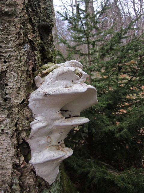
Fungi on a tree, an indication of internal disease

Crossing Whitetop Mountain Road (USFS 89), the views opened up once again.  There are campsites that looked very uninviting to me, too exposed right by the road, and I would not choose to camp there alone.  There is a spring, however, that is convenient to top off your water supply as you march on to a more conducive campsite or the next shelter 6 miles away.  On this section of the AT, from Elk Garden to the town of Damascus, there are numerous options for overnights, including crossing roads and hitching rides into town, etc.

Less than a mile from the road crossing is the highlight of this section:  Buzzard Rock, a grand feature worthy of a dayhike all on its own.  (If you are Googling, be sure you find the one associated with Whitetop Mountain, VA and not the one near Front Royal, VA).  This is an impressive rock outcropping at 5,080 feet.   

A careful scramble to the top is rewarded with an inspiring 360-degree view, including this one southwest across multiple ridges in North Carolina and Tennessee.

From Buzzard Rock the trail steadily switchbacked downhill to Beech Mountain Road (VA 601) where I parked my car eons ago on a snowy Sunday morning.  Here I unloaded my backpack of everything except the essentials for the last 4 miles, rain jacket, water, camera.  I took my time, ate a snack, thought through what I needed and what I could leave behind.  Mike’s plan was to hike to this point and then drive my car to meet me at my ending at the Luther Hassinger Memorial Bridge.

The remaining miles were a lighthearted blur, no weight, skipping through the trees, clear skies, one puzzling curve about nine-tenths of the way around a small pond.  Stopped to say hello to Lost Mountain Shelter, the first shelter south of Thomas Knob and a comfortable-looking home away from home.  In what seemed the blink of an eye I was walking onto the Virginia Creeper Trail at the Luther Hassinger Memorial Bridge.  Cyclists were streaming by in both directions and I had to choose my moment to get onto the bridge.  Two women stopped to chat (no, I’m not a thru-hiker, just a weekend warrior) and take my photo.  The trip that started in lots of cold weather layers ended in shorts and a tee shirt.

Mike was waiting as I knew he would be.  We retrieved his vehicle and stopped for a bite to eat at the Log House in Volney, the only customers for the buffet on a Tuesday afternoon.  Then we went our separate ways home.

Mike’s help to me on this trip was both typical and extraordinary.  He has many years of experience in the outdoors and there are few places I can name that he has not explored, from Crowders Mountain just 20 miles from Charlotte to Nepal.  Among many skills, he’s taught me the concept of hiking at a personal sustainable pace, no matter what everyone else is doing, and the pleasure of walking alone and then sharing camp at the end of the day.  Some of us have hiking goals and lists, but for Mike it's not as important what trail you're on as long as you're out there somewhere.  Nature changes every day.  I will follow his example and pay it forward for another traveler soon.

"Now I see the secret of the making of the best persons. It is to grow in the open air, and to eat and sleep with the earth." ~Walt Whitman, "Leaves of Grass”