Tuesday, January 26, 2010

The Book Club Gals Strike...Er, Hike Again

Stone Mountain State Park – 1/2/10 – Stone Mtn Loop Trail/Wolf Rock Trail/Cedar Rock Trail/Stone Mtn Loop Trail – 4 Miles

No better way to start off the New Year than with a frosty hike! My book club pals (plus Ellen’s sis, Joan) were game for a trip to Stone Mountain State Park. After making sure that everyone had plenty of warm non-cotton clothing, we hopped in Joan’s van and headed north. We pretended not to be intimidated by the dropping temperature and smiled bravely as we pulled into the VC parking area – 22 degrees, not too windy, and blue skies! The Loop Trail was closed because of ice but they didn’t say nothin’ about Wolf Rock and Cedar Rock…so off we went.

 The steepness of Wolf Rock Trail can be daunting, but we needed the warmup and stopped a couple of times to shed layers. I told the group that I wanted them to be mad at me for being too warm, not for being too cold – I think it worked.

There was enough ice and snow on the trails to make us feel adventur- ous.

 An old rock wall on Wolf Rock Trail


I was rewarded with smiles and laughter at the top of Wolf Rock as all agreed the hard work was worth it. Nobody there but us book lovers and the grand view.


Joan, Kathy and Ellen and the tree that split Wolf Rock


Getting close to the edge yet?


Even the sunshine could not keep us warm for long, though, so we continued on our loop. My ears were covered with two layers and we were chattering away, when suddenly I felt rather than heard a noise, kind of a rumbling vibration. At the same time, the women in front of me all stopped, looking to the right with big eyes and open mouths. Can’t see anything…what did it sound like, ladies? They described a vocal animal sound, a large animal. Later Ellen found a website of animal sounds and sent out the one that most closely approximated it: a bear. How exciting! I had assured them that there were no bears in Stone Mountain State Park, especially not in winter. Ah well…

On Cedar Rock we paused again for photos with Stone Mountain as a backdrop, but again we could only swallow a few handfuls of gorp and keep moving. No leisurely lunch today! As long as we were moving we were warm and happy. We met other hikers down in the valley near the Hutchinson Homestead. After checking out the old buildings, we crossed the big bridge back to the Loop Trail.


Along this section is a large overhang with dangling icicles – a great photo op for Leida.

Back at the trailhead we congratulated ourselves on no falls and no injuries and then cranked up the heat in the car. We stopped at the little country store for hot chocolate, sitting around the table in mismatched wooden chairs talking about everything like women will do. As on our September outing, the sense of satisfaction and accomplishment was quite gratifying for everyone, including myself. Our hike was short on mileage but big on fellowship and I thoroughly enjoyed my day. Can’t wait to go out exploring with the book club ladies again!

In all things of nature there is something of the marvelous. ~Aristotle

Wednesday, January 13, 2010

White Blazes and Blaze Orange

MST Hike – Day Seven – 12/8/09 – Folk Art Center to Bull Gap – 8.9 Miles  

(Read Danny’s thoughts about today’s hike here.)

Bad weather was still threatening and now the concern was icy roads involved in shuttling. I think Danny and I were still a little bit in denial as to the degree of difficulty in planning ahead during these winter months. The compromise de jour was hiking the MST section from the Folk Art Center (where we ended the previous day) eastward to Bull Gap. Danny’s husband, Lenny, helped us set up this shuttle and we started off from the Folk Art Center, ready for a rain-filled day. And once again the weather forecast was off.

While temps were certainly cool, the rain held off. The hiking was more of what I prefer, rolling uphills and downhills and (mostly) out of sight and sound of the Parkway. Most likely the low amount of traffic on the BRP was due to its closure north of Craven Gap - few commuters or even sightseers today. In addition, the MST crosses the Parkway only a couple of times so here was the chance to stretch our legs and pretend we were in the wilderness. Every view, however, included houses on the neighboring mountains. Perhaps when the leaves are out one can be fooled into thinking the houses don’t exist.

The trail took us through gnarly mountain laurel tunnels, certainly beautiful during bloom season. There is beauty in the bare wood of winter too.

 The mountainsides are steep in this section and as we paralleled the Parkway, it was sometimes 100 feet above our heads or 100 feet below. As we crossed a stream below the road, we noticed this rusting barrel. Danny crawled up the bank and discovered a cavelike structure of stacked rocks. A former moonshining site?

“How the mighty have fallen.” How did this old grandfather tree meet its fate? Rotting from the inside out, followed by a wind storm or an ice storm giving the final push? The MST trail builders cut through it and kept going.

Someone out there can probably tell me what these brown puff ball shapes are at the base of this tree. One poke with a finger and they imploded with a powdery whoosh.

One long uphill brought us to Lunch Rocks, so named because it’s a good place for a pause and a snack. Here was a reminder of our proximity to humans as it overlooks a road and an Asheville neighborhood.

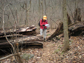
This was my first experience hiking while wearing blaze orange during hunting season. Although we were walking on protected land, the BRP corridor is narrow and it is possible for hunters and bullets to trespass unintentionally. We met a few dayhikers out today, one of whom took this photo as we paused at Craven Gap. What they did not realize is that we had both taken a trail break about two minutes before they came on the scene. Don’t ever assume you are alone on the trail!

At Craven Gap we crossed the road and climbed high above the Parkway. The trail wandered through boulder fields and up these wonderful steps made by the CMC trail builders. About a mile from our end point the rain began, light at first and then in earnest. We put on rain gear and hustled along, grateful that we had not had to walk in a downpour for the entire day.

It’s always good to see my car right where I left it.

A wonderful consolation for our short day – Danny and I had a delicious dinner at a Japanese restaurant and attended an author’s presentation at Diamond Brand in Fletcher, NC. William Hart, Jr., author of 3000 Miles In The Great Smokies, gave an informal and delightful talk and it was truly a thrill to hear him read his work. Mr. Hart has hiked in the Smokies for decades and kept a detailed diary of notes of every experience. His book is a compilation of thoughts and reminiscences of his wonderful days and nights there.  

Postscript: Danny and I had plans to hike a long section of the MST the next morning, studying the weather forecast late in the evening and again early in the morning, but ultimately decided to cancel because of predictions of rain, ice, snow, sleet and poor road conditions getting to the trailhead. I headed home. In the flatlands near Charlotte the skies were blue and harmless, but we learned later that there were many downed trees on secondary roads and the Parkway was now closed, probably until April, so we made a wise decision. But what will we do until the spring thaw?  

Bad weather always looks worse through a window. ~Author Unknown

Sunday, January 3, 2010

Pure MST

MST Hike – Day Six – 12/7/09 – 13.4 Miles 
(Click here to read Danny's blog about today's hike.)

A shiver of excitement and anticipation went through me when I saw the small vertical post: Today I would take my first steps on the plain old MST, not a Smokies trail that runs concurrent with it, not a road section because there is no existing trail, but the bonafide, pure MST.

The weather forecast plays a different role in this project than in my Smokies hiking. In section hiking a linear trail, shuttling is always a major consideration. If one road was closed in the Smokies, well, another one was open so I just chose a different trail. Very seldom did the weather stop me in my tracks. But the MST…well, flexibility is a skill we must exercise often. Danny and I had planned four days of MST hiking and already had to abandon our original premise of hiking the entire trail “in order” from west to east. The BRP was already closed for snow and icy conditions, so we capitulated to hiking out of sequence in the Asheville area. Today’s forecast was not great either – yes, it would rain, but exactly when and how much? So today we opted for an easily accessible route in case the rain was significant.

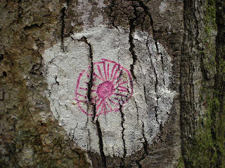
 The Carolina Mountain Club maintains the MST around here and trail conditions are top-notch, including great bridges. We were almost always in sight of a white circle blaze. In the Smokies I carried my trusty $1 map and all the junctions had signs confirming that I was where I thought I was. Not so the MST! The white circle has become my new obsession and it is not always found on trees:

On rocks


Okay, on a tree but very creative


On the utility pole


Don't forget to look underfoot


In addition to the white blazes (which will not always be so conspicuous or plentiful) we have help from a couple of very timely publications. The first, “Trail Profiles and Maps: From the Great Smokies to Mount Mitchell and Beyond,” second edition, is hot off the press, authored by Walt Weber of the Carolina Mountain Club. The topo and profile maps on facing pages for each section are an invaluable tool for us and could not have come out at a better time. The second is “The Thru-Hiker’s Manual for the Mountains-to-Sea Trail of North Carolina 2009" by Scot “Taba” Ward. No maps, but a minutely detailed mileage listing of every bump in the trail, stream locations, side trails to ignore, possible camping spots, left and right turns, you name it. Danny copied the pages for personal use for each day’s hike and we constantly referred to them. Weber’s guide will get us to Black Mountain Campground east of Mount Mitchell and Ward’s guide will assist us all the way to Jockey’s Ridge State Park.

Our route ran eastward (always eastward!) from NC 191 to the Folk Art Center, curving around the bottom and east edges of Asheville, so we were not hiking “in the wild.” This is also perhaps the mildest section in the western region, gentle ups and downs totaling about 2,000 feet elevation gain over 13.4 miles. But new miles are new miles.

How different it feels to walk on soil! We were never far from traffic noise and even sight of civilization and we crossed a number of overpasses of Asheville’s major roads, but feet on dirt, kicking up rustling leaves, is so much better than pavement. Even the views from the BRP on our last outing did not engender the same feeling when we trudged along that manmade stuff. I was very happy to be back in the woods.

Within the first couple of miles today we began to walk parallel to a very high black chain link fence, discretely invisible until you are within a few yards of it. It seemed to say, “We want the woodsy view but not YOU!” It even went over the creek. Eventually we saw a sign designating a nice gated community behind the fence. Hope they are enjoying it.

We criss-crossed the Blue Ridge Parkway numerous times and walked directly on its bridges that spanned major roads like I-26 and Highway 25. We stood on the bridges and waved at the cars, even got a few waves back – not a very common trail experience. The MST passed through a tunnel underneath I-40. Although not the wilderness experience one may be looking for, I found this section very interesting, kind of like a scavenger hunt. Where would the blazes take us next? And how awesome that you can walk this far around Asheville!

Bridge going under I-40


Railroad crossing


A very narrow stile

Our final destination was the Folk Art Center where we had dropped my car. The rain turned out to be just a rumor. All in all, an easy day and a good feeling of making forward progress once again. Tomorrow’s plan is for a longer, more strenuous stretch…alas, all plans are subject to change…  

Flexibility: characterized by a ready capability to adapt to new, different, or changing requirements ~ Mirriam-Webster

Friday, January 1, 2010

Kitsuma Peak

Kitsuma Peak – 12/6/09 – Youngs Ridge Trail/Kitsuma Peak Trail/Point Lookout Trail – 10.1 Miles


The Berg Wanderers and the Carolina Mountain Club sponsored a joint hike to Kitsuma Peak. Danny Bernstein led the hike using her route from her book, “Hiking North Carolina's Blue Ridge Heritage". The dubious weather forecast caused several folks to drop out and as a result they missed a fine day of hiking. As my friend Mike often says, “Don’t let the weatherman tell you what to do!”

Outside of my Smokies element, I am just a follower. Everything I could tell you about this hike is found in Danny’s book, so to avoid plagiarizing I’ll keep it very short and let the pictures do the talking.

The hike begins in the Old Fort section of the Pisgah National Forest. Youngs Ridge Trail is a steady, moderate uphill climb, great for warming up.


Like ants we crawled up the mountain. CMC does this hike only in the wintertime – for the views, of course.


Ribbon of I-40


I love bare tree limbs and mountains in the background


We eventually dipped down to within spitting distance of I-40, with nothing between us but a guard rail and a wire fence. From here we walked on the secondary road to Point Lookout Trail. The latter half of the hike consisted of Point Lookout Trail, recently repaved, making it a road walk, not one of my favorite things, but the history of this section of the hike is what is important. The Southern Railroad tracks run in and out of tunnels through the mountains. Many man-hours (and deaths) were part of this incredible feat of bringing the world to the mountains.

Point Lookout itself was once a tourist stop on this old road overlooking Royal Gap. It’s hard to imagine the general store once perched on the steep hillside. The benches and flagpole (lighted by solar power at night) was recently installed as a Boy Scout Eagle project. The view down into Royal Gorge From here the road wound gently down the mountain, an excellent training road for cyclists, no worries about traffic.


Near the end of our hike we passed into a rural commun- ity complete with a little white church and cemetery and these curious fellows looking for a handout.

We took a quick side trip to Andrews Geyser, a manmade monument to honor a railroad exec in the 1880’s. Read all about it in Danny’s book! After these adventures our group split up and headed home. My plans were to stay at the Bernsteins’ home for a couple of days so that Danny and I could log some miles on the MST. With plenty of time still left in the day, she and I visited the Grove Park Inn (I had never been inside) and wandered the labyrinth of the high life in our hiking boots, admiring the view and the gingerbread house display – a novel way to end the day.

Wherever you go, no matter what the weather, always bring your own sunshine. ~Anthony J. D'Angelo