Pilot Mountain State Park – 2/4/14 – 9 miles
Every week of January 2014 I attempted to hike on the AT in
Virginia…and each plan was foiled by weather, too much snow, too cold, too
windy to go alone. So in early February
I saw a one-day window of opportunity and made a run for it – not to Virginia,
but to Pilot Mountain State Park in NC. Three reasons to go: One, a shorter trip than going to VA on a
weekday; two, I hadn’t been there since the kids were small; and three, the
Mountains-To-Sea Trail has been rerouted to pass through the park.
Called the most recognizable mountain in North Carolina,
Pilot Mountain is actually two quartzite pinnacles connected by a narrow saddle,
the most prominent remainder of the time-worn Sauratown Mountain range. Big Pinnacle rises to 2,421 feet. From the website: “To the native Saura Indians, the earliest
known inhabitants of the region, Pilot Mountain was known as Jomeokee, the
"Great Guide" or "Pilot." It guided both Native Americans
and early European hunters along a north-south path through the area.”
In addition to the Mountain section, the park stretches to include a section of the Yadkin River, connected by a 6.5-mile narrow corridor. The Mountains-To-Sea Trail follows the corridor up from the River portion, along the eastern edge of the mountain section, then turns eastward towards Hanging Rock State Park. This reroute occurred after I completed the MST in 2011.
I was chomping at the bit for a challenging hike to test my
knees and I found one.
The Park was nearly deserted on this cold but clear Tuesday
morning. During my nine-mile hike I saw
two dayhikers, two trail runners and a guy walking his dog. On a warmer Saturday visitors can number in
the hundreds.
A little Zen on the Grindstone Trail, which begins at the park
office and passes by the camp- ground
loop, making easy access for campers to hike
to the main attraction summit.
Past the campground, the Grindstone Trail climbs moderately and
at 2.5 miles it forks; the right option is a connector to the Ledge Spring
Trail. I took the left option (a Ledge
Spring/Grindstone Trail section running concurrently) and climbed .8 miles more
to the summit area parking area, which was enormous and deserted except for two
people who had stepped five yards from their car to look at the view.
And the view is this
A short path from the parking lot leads to the summit of Little
Pinnacle and the prime viewing spot for what you came for: Big Pinnacle
Of course the next thing to do is follow the Jomeokee Trail
as it crosses the saddle and encircles Big Pinnacle. I was thrilled at my great good fortune to be
there totally alone.
Looking straight up the rock, see trees growing out of
crevices
Looks like a climber’s nirvana, doesn’t it? But climbing is prohibited on Big Pinnacle
for several ecological and practical safety reasons. For instance, making it safe for climbers on
top would require building extensive railings and stairs which would greatly
detract from the natural view. Some
(most) things are better just left alone.
However, climbing is permitted on the back side of Little Pinnacle along
the Ledge Spring Trail, the next section of my hike.
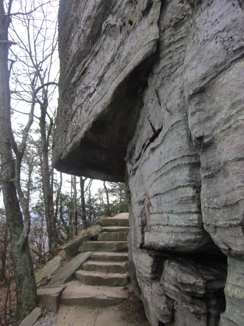
Ah, Ledge Spring Trail, strenuous – yes! I imagine that tackling this baby uphill is quite a workout. Nearly a mile of continuous stone steps going downhill was strenuous as well and my knees began to talk aggressively to me the way they did back in November. The key on this section is to go very slowly and enjoy the towering rock features with climbing route names like Pool Hall, Nuts & Bolts, Three Bears and Devil in the White House. The up side of my day (no people) was also the down side (no climbers).
I turned left onto Mountain Trail, which continues a winding
descent for 2.5 miles to Pinnacle Hotel Road and the entrance to the Corridor
Trail connecting to the river portion of the Park. Along this section I saw the devastation of last
year’s controlled burn that, well, got out of control. I remember it well because Jim and I hiked at Hanging Rock State Park that day and could see the smoke from 22 miles away.
But look what’s coming back – mountain laurel. Nature will always win.
At the end of Mountain Trail I took the very short road walk
to Grassy Ridge Trail and began to climb what I had just descended. By now my knees were officially hurting and I
took it easy for the last 1.5 miles. I
was glad to see the park office and the end of my loop.
There you have it, the mountain section of Pilot Mountain
State Park. I skipped the .6-mile
Sassafrass Trail that is accessed from the summit parking area; otherwise, I
walked all the trails in the section. I
admit to my prejudice against visiting this park on a weekend day. In my opinion, there are not enough trails to
spread out the crowd unless you are willing to venture past the summit and hike
the larger loop. Otherwise, I recommend
Tuesday mornings.
“My favorite weather is bird-chirping
weather.” ~Loire Hartwould


No comments:
Post a Comment