Showing posts with label Big Bend National Park. Show all posts

Thursday, November 3, 2022

Big Bend National Park: Lost Mine Trail & More Cowbell

Big Bend National Park: Lost Mine Trail, Window View Trail
 & More Cowbell (I Mean Terlingua)
 1/17/22 – 5.2 Miles

Emory Peak, Toll Mountain and Casa Grande Peak (L/R)

Groundhog Day: the long drive from Alpine to Big Bend NP again. This was our last day in this jewel of a park and we’re actually going hiking before we go home. We headed to Chisos Basin, the center of it all - a pile of mountains in the middle of surrounding flat desert - the highest peaks and the biggest views.

Emory Peak, the highest point, is 7,825 feet…but we’re not going up there. The shortest out-and-back trip to its summit is more than 10 miles. Rather than spend a whole day on one trail, we tackled a half-day hike in the neighborhood: Lost Mine Trail.

My mantra en route to trailheads and campgrounds: Please let there be an open space, please let there be an open space, please…

Lost Mine Trail is the most popular hike in Big Bend NP and there is limited trailhead parking. If it’s full, the alternatives are parking at Chisos Basin Visitor Center and walking the twisty-turny paved road back to the trailhead…or choose another hike. Perhaps we were in between the morning and afternoon waves on this Monday morning of Martin Luther King weekend. We got the last parking spot.

Trailhead sign and a reminder of who lives here

The name “Lost Mine Trail” can be misconstrued as climbing up Lost Mine Peak itself,
 but it actually climbs a ridge to a viewpoint of Lost Mine Peak to the east
 and Casa Grande Peak to the west

As we’ve learned to expect, we had a chilly start. There were not too many people on the trail, at least not by Great Smoky Mountains standards. The path was rocky, dusty and worn, but holding up well for the years since it was built by the Civilian Conservation Corps (CCC) in the early 1940’s.

We started out in an oak and pinyon pine forest with glimpses of what’s ahead

The trail climbs gradually along the base of Casa Grande Peak. About one mile in, it reaches a saddle where the view busts wide open.

Casa Grande Peak, totally dominating like a fortress on a mountaintop

Casa Grande Peak and its sidekick Toll Mountain

Looking south into Juniper Canyon and beyond

After reattaching our dropped jaws, we continued on as the trail turned left away from the peak views to climb long switchbacks to the ridge (quad workout!)

Check out the CCC stonework on the right edge

Changing perspective, looking northwest at Mount Huffman in the center,
Casa Grande on the left

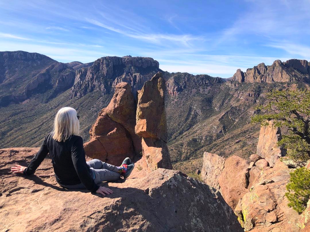
The last few switchbacks were steep, rocky and exposed, requiring full attention on your feet unless you stand still to check the view, which I did about every ten steps. 

The last half-mile was a mostly level walk along the ridge (also exposed with steep drop-offs)

Trail’s end is a pile of house-sized boulders to climb around on for vantage points looking west across Juniper Canyon at Casa Grande Peak and Toll Mountain, and south to Mexico. To me, the Chisos Mountains resembled the Grand Tetons without snow.

Looking south, an unnamed rock pinnacle in the foreground, Elephant Tusk sticking up
 like a tooth on the middle horizon, Mexico on the far horizon

Disclaimer: I didn’t have a reference point for Lost Mine Peak but this is a photo looking
 in that direction from the ridge

We ate lunch sitting out on the rocks, chatting with a man who was very knowledgeable about the park. He lives in Virginia but had visited Big Bend a dozen times, feeling drawn to the vast, mystical, unknowable landscape.

As the afternoon swarm of peeps arrived, we retraced our steps. The air had warmed up and the hike back seemed to take longer than expected. As I walked I wondered, as I often do when exploring the natural wonders of this country, whether I would ever return to this trail. Felt grateful for this adventure with my family on a beautiful clear day.

At Chisos Basin Visitor Center we changed clothes and indulged in ice cream. Asked about visitation numbers, the ranger keeping count of folks coming in the door told us it was a slow week. Between Christmas and New Year’s they saw around 2,300 people per day, while today Laura was number 138. I was a bit surprised since this was a holiday weekend in cooler temperatures.

From the VC, we walked the quarter-mile Window View Trail, a nice way to wind down and change gears. So far, everyone else had seen a roadrunner except for me, and then one appeared in the parking lot!

We hadn’t had enough of Terlingua, so we drove west from Chisos Basin as we waved goodbye to Big Bend National Park. After a beer on the rooftop deck at High Sierra Bar & Grill, we took a walk around the ghost town’s self-guided tour of old buildings, some intact and some piles of rubble. I felt appreciation for the grit required to live through the town’s hey-day of mercury mining and later decline. Read more about Terlingua’s history here. Google will give you gobs of information about what to do there.

The most intriguing place in this scrappy town is the Terlingua Cemetery, at first glance a small collection of rough graves that deserves a closer look. It’s on the National Register of Historic Places.

Graves are arranged somewhat in row formation, covered by stones and dust and dirt, most facing east. Some are decorated poignantly with flowers, candles, coins and personal items. Some have makeshift crosses. Some are neglected. It seems a sobering place to be laid to rest, yet there is a sense of community and levity here. The cemetery has a following as a spiritual site.

Epitaph: "Not all who wander are lost"

Pay a visit, make a toast, leave the container

Some fancy new neighbors

We scratched the surface of this corner of Texas, realizing that it would take a lifetime to explore it all (don’t forget Big Bend State Park right beside it). Everything we packed into three days was worthwhile and we’ll count down the days until we can return.

“If a man’s from Texas, he’ll tell you.
 If he’s not, why embarrass him by asking?”
 ~John Gunther


Friday, October 14, 2022

Big Bend National Park: Crossing the Border - Boquillas del Carmen, Mexico

Big Bend National Park: Crossing the Border - Boquillas del Carmen, Mexico
 2 miles - 1/16/22

The Rio Grande

My slightly facetious Facebook post for January 16, 2022: "Charlotte friends, we know you're dealing with snow and ice today. Well, here in Big Bend, Texas, there's ice in the margaritas."

Our merry band got a late start this morning, on the road by 8:45am. With all the drive time in our plans, we get either a relaxed morning or a relaxed evening, not both. Pour me another cup of coffee.

Jim took a turn driving, giving Zach a chance to enjoy the scenery. We headed east on Highway 90 to Marathon, then south on Highway 385 to the Persimmon Gap entrance to Big Bend NP.

Morning light on the mountains

Looks like some fun folks in front of us

Quick stop at Panther Junction Visitor Center before heading towards
 the eastern edge of the Park

Today’s big adventure was visiting the tiny border village of Boquillas del Carmen, Mexico. Founded as a mining town in the 19th century, Boquillas residents’ present-day economy relies on tourism. Read more here about its history and attempts to create an international U.S.-Mexican peace park here.

I was super curious and a little bit anxious about how crossing the border works at the Boquillas Port of Entry. It’s actually low-key process with two primary rules: have your passport to re-enter the U.S. and don’t bring back any “souvenirs” like rocks, minerals, dirt, tobacco, alcohol, raw food products or products made from animals or parts of animals. [If you have to think about it, don’t bring it back.]

Lots more information for a visit on this great website.

The border patrol folks do not allow photos inside the building but have provided a fun souvenir
 photo op after you pass through

We walked a quarter mile to the Rio Grande River, flowing lazily towards the Gulf of Mexico, knee deep and underwhelmingly narrow – of course, that’s why this is a crossing point. A man with a rowboat ferried people across, $5 per person, room for 4 passengers at a time. The ride back to the U.S. is free. (Wading across the river is allowed, but it is considered supportive of the local economy to use the ferry.)

The photo below focuses on the rowboat ferry at the shore, but look closer at the mountain range on the horizon: the Sierra del Carmen range in Mexico. The highest peak in the escarpment, on the far left, is called Cerro Pico Cerda (7,022 feet) or El Pico.

We opted to walk the .75 miles to the village, although locals at the riverside offer transportation
 via donkeys and horses or pickup trucks

As we approached the first houses, children ran towards us with cardboard placards holding woven bracelets/souvenirs. This happened every time we approached a building or if we stood still and looked around (often the same children). Many homes had souvenir displays, embroidered towels, beaded figurines and ceramics.

There are two restaurants in Boquillas, situated across the street from each other, both waving us in to be seated. We chose the one on the right – Boquillas Restaurant – because we could see the covered outdoor seating with customers eating.

A savvy little chihuahua roamed underneath the tables begging for food
(and peeing on backpacks!)

Laura and I are ready for some sustenance

We ordered goat tacos, cheese enchiladas, and chicken empanadas to share. Laura and Zach went straight for the margaritas while Jim and I had Cokes in old-fashioned bottles. The food was delicious and we consumed every crumb.

We wandered further along the main street through the village. Some homes had souvenir shops on their front stoops and beckoned us to look over their wares. I bought a set of small ceramic cups for drinking shots of tequila, mezcal, and our new discovery – sotol! (We didn’t take photos of people and tried to be discreet in photographing buildings.) 

A childcare center

A retaining wall made of 2-liter soda bottles filled with sand

We noticed solar light poles and discovered that the entire village operates
 solely on solar power 

The solar panel installation

The walk to the last building took only a few minutes. We turned around and headed to Boquillas’ second eatery, Jose Falcon’s Restaurant-Bar & Souvenir Shop. Its patio boasts an amazing view Boquillas Canyon.

Margarita time for me

One more chance for a ride to the riverside

We strolled back to the Rio Grande crossing for our free 3-minute rowboat ride back to the U.S. The re-entry procedure consisted of facing a camera and putting my passport in a scanner, and a border patrol officer in another location spoke to me by phone to verify my identity.

Jim went first and they could not find him in the system. He had to answer lots of questions, get another agent on the call, wait around and bite his nails for 15 minutes. When they got to me, they only asked if I was a U.S. citizen…yes…welcome back to the United States.

[If you’re considering visiting this part of Big Bend NP but don’t want to visit Boquillas, there are other things to do. We skipped Rio Grande Village and the Hot Springs – next time!]

At Boquillas Canyon Overlook, we stood at the edge of the earth and squinted to make out the mouth of the longest and deepest canyon in Big Bend, where the Rio Grande has cut a 1,300 foot deep chasm through the Sierra del Carmen Mountains (near my left shoulder in the photo below). 

Why do humans like photos of themselves in front of natural features?

Maybe I just like photos of Jim

Sierra del Carmen, El Pico on the left

We built in time on the drive back to visit the Fossil Discovery Exhibit, an open-air display of information boards describing the history of dinosaur life in Big Bend, discoveries of fossils, and replicas of fossils. The massive bulk of these creatures fits with the magnitude of the landscape. The exhibit is open 24/7 and should be one of the first things on your Big Bend list. It gave me a new perspective on everything I saw in the Park and that night I dreamed about dinosaurs roaming around.

Driving to home base, on Highway 90 between Marathon and Alpine, we were gifted with a magnificent sunset. When we pulled over to get a better look, we realized that the moon was rising behind us as we faced the sunset. The four of us ran back and forth across the road, madly shooting from different angles, until we gave up and just watched.

“Day is done, gone the sun
From the lakes, from the hills, from the skies
All is well, safely rest
God is nigh.”