Thursday, June 29, 2023

Bracken Preserve in Brevard NC

Bracken Preserve – Brevard NC - 7/19/22 – 9.3 miles

In July 2022, even the mountains offered little relief from the relentless heat. Still, outside is soothing to the soul and I must go.

Bracken Preserve in Brevard, NC was introduced to me via Conserving Carolina. The organization does amazing work in Western NC, playing the long game of working to protect lands for future generations.

Part of Conserving Carolina’s PR is highlighting gems like Bracken Preserve. They got my attention with the White Squirrel Hiking Challenge 6 because you know I love a challenge list that takes me to new places. 

Bracken Preserve is easy to find, at the edge of downtown Brevard yet a world away. The trails have names and color blazes, but I won’t get into all that. The turn-by-turn directions for this hike are here. I followed this route and included the short interior connecting trails. Why not?

All together I hiked every bit of the Preserve and enjoyed every humid moment. A surprising amount of ups and downs have been squeezed into 395 acres, not a leisurely stroll.

Show and tell picture time! Did someone say more mushrooms?

Bridge at Renzulli Falls on the Brushy Creek Trail

Carlo Renzulli, a native of Italy, was a violinist with the New York Philharmonic. Why does his name turn up in the woods? Members of his family were ardent supporters of nearby Brevard Music Center as well as Bracken Preserve.

Chanterelles

Amanita jacksonii – I went down a fascinating YouTube rabbit hole identifying this

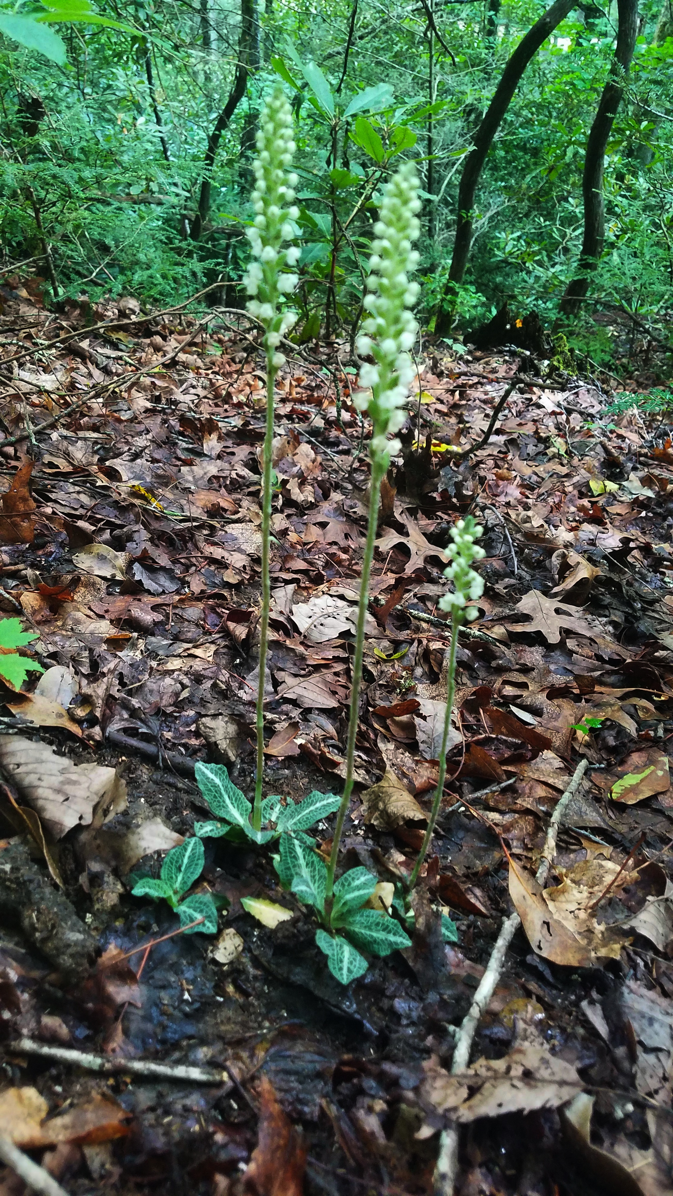
Okay, a break from the fungi. Rattlesnake plantains bloomed in abundance (we all know my poor track record with photographing them) and I spotted a pair of yellow-fringed orchids and a crane-fly orchid. Some slopes beside the trails were thick with rhododendron, others covered in ferns. Birdsong was surprisingly constant, unlike in deep forest. Are the birds more accustomed to people here so near to civilization? Standing still and listening made my spirit soar.

Also on Brushy Creek Trail: a campsite and small shelter where I took my lunch break 

A red eft

Bracken Preserve has been open since 2012 and in 2019 a new shared use trail was completed.  The pink-blazed Pinnacle Trail rubs up against Pisgah National Forest, and mountain bikers as well as hikers are very happy to extend their range. The name refers to the Pinnacle community that once thrived in the area. [Read more here.] From the article:

“Signage in the Bracken Mountain Preserve marks the history of the Pinnacle community. Among the founders of Pinnacle were Laughing Water, a young woman from the Blackfoot nation, and Tom, an African-American, both of whom had escaped from captivity. Laughing Water and Tom moved their large family to these mountains in the early 1860s to avoid typhoid fever.”

Love the pink blazes


The climb up to the boundary is significant, tight curlicue switchbacks, crisscrossing old forest roads. I kept my eyes and ears open but didn’t encounter any mountain bikers today.

A cool breeze awaited at the boundary ridge line as the Pinnacle Trail straightened out and relaxed. The trail doesn’t quite go over summit of Burl Mountain so I detoured to find the top. (I didn’t locate a survey marker so I estimated.) In doing that, I inadvertently stopped the GAIA track but quickly realized it and started a new one. Always learning! As Jim says, “No backslapping ‘til it’s all over.”

Bracken Mountain Trail plunges back downhill on long benches with tight switchbacks. I assume this is the way mountain bikers go up to the top and then careen down the Pinnacle Trail. Brushy Creek comes back into the mix, crossing several times on the descent. Before I could say “Amanita jacksonii” I was back where I started.

For most of my 4.5 hours in Bracken Preserve, I was alone. I encountered six people in the first mile, three people in the last mile, and no one in between. As I was putting my hiking poles in my car, three mountain bikers exited behind me from parts unknown. Retirement hiking on a Tuesday!

Since my hike in July 2022, Conserving Carolina has acquired 34 additional acres to expand Bracken Preserve (read here.) 

Perfect ending

“There are always flowers
for those who want to see them.”
  ~Henri Matisse

Friday, June 23, 2023

Pisgah 400: Loose Ends at North Mills River and Pink Beds Connector

Pisgah 400: Trace Ridge/Wash Creek/Bear Branch Trails and Pink Beds Connector
 7/18/22 – 9 miles

Continuing my string of hikes in Pisgah National Forest following convoluted routes and tying up loose ends, today I hiked two separate routes.

The first was a couple of miles past North Mills River Campground, starting from the Trace Ridge parking area on FR 142 (Hendersonville Reservoir) off of FR 5000 (Wash Creek Road).

Okay, I’ll spare the turn-by-turn description and go with the photos. My hike started from the “P” in the middle left of this GAIA topo track of the Pisgah Ranger District.

But first…at the parking area I talked with a young guy named Nate who was camping out of his truck, asking him about the Trace Ridge trailhead (it goes in both directions, trying to get the right one. I was disoriented even with GAIA. That’s what Pisgah NF will do to you). He gave me helpful info about trail conditions because he had biked it the day before. With Nate was his black Lab named Jim, a sweet elderly fella whose eyesight was failing. A chance encounter, they were gone when I finished my hike. I wonder where they are now.

Trace Ridge is a rutted, sometimes-muddy bike trail. Like many shared use trails in Pisgah,
we all just gotta get along.

An unusual sign, makes me think that it's been hard to wean folks onto the reroute

Trace Ridge Trail soon connects with Wash Creek Trail, gentle loamy soil and an easy descent to North Mills River. Turn around, retrace steps and pass Trace Ridge – wait, I thought we weren’t doing detailed directions…

North Mills River

Deceptively tranquil at times, water so clear it’s invisible

Rattlesnake plantain was everywhere, one of my favorites. The foliage is easy to spot
 and the bloom is very hard to photograph

Rattlesnake plantain

Not-ready-yet blackberries

Wash Creek Trail levels out on a wide old roadbed and leads to FR 5000

Low bridge where FR 5000 passes over Wash Creek

After crossing this bridge and the forest road intersection, I started on Bear Branch Trail that pretty much goes straight up to another forest road. This trail begins at Wash Creek Horse Camp, which was empty today. The horse folks have a pretty nice setup, picnic tables, campfire rings and a privy too.

Nothing much to look at on Bear Branch Trail except a few new flowers. 

As far as I can ID, the flower below is a crane-fly orchid, sort of a camouflage flower. What drew my eye to it? After years of poring over flower ID books, there are a lot I am familiar with that I haven’t yet seen in real life. I am attentive to shapes as well as colors. Sometimes I just get lucky, take photos of anything interesting and look it up later.

When I reached the forest road, I knew from reviewing the map that this was my turnaround point, so I retraced my steps to the horse camp and walked the gravel road back to my car.

The back of the stop sign in the middle of the woods seems to be a favorite for sticker display

(Looking at the GAIA track later that day, I was dismayed to see that I had turned around before the end of Bear Branch Trail – about a third of a mile short! The gravel road where I turned around was not on the GAIA maps, but I assumed it was the one I’d made a mental note of.)

Today’s second loose end was the Pink Beds Connector, an interior trail that nobody but diehard map completers and maybe someone long ago with the Forest Service ever sets foot on. The popular Pink Beds Loop is easily accessed from the Pink Beds Picnic Area on Highway 276, but I accessed the connector trail from the same parking area that Jim and I started our High Falls hike ten days ago.

The blue track is my hike on the Pink Beds Connector

Déjà vu all over again 

At the start of the trail, an overgrown camping area and a gauging station (still functioning?)
 beside North Mills River

A closer look at the gauging station

Within a few hundred yards, Thompson Creek comes in on the right,
 probably a rock hop most days but I had to wade it

The trail was level but overgrown and obstructed by numerous blowdowns. It ran very close to North Mills River, rhododendrons encroaching the path. There were no blazes (maybe obscured by overgrowth?) and no evidence of maintenance in a while – stretched resources, low priority or does this just need to be decommissioned? 

At least there are pretty flowers

Flowering spurge

A jerry-rigged bridge, doesn’t look like Forest Service work to me

Something got washed away here – another wade with a muddy bottom

The return hike was slightly better only because I knew what to expect. Not my most exciting day in Pisgah National Forest, but the weather was cooperative and it was still better than a day at the office.

Postscript: Nine days later I returned to the North Mills River area with a friend and rehiked Bear Branch Trail out-and-back to its end.

“When one tugs at a single thing in nature,
 he finds it attached to the rest of the world.”
 ~John Muir