Showing posts with label Cold Mountain. Show all posts

Sunday, November 24, 2024

Pisgah 400: Art Loeb Trail & Cold Mountain

Pisgah 400: Art Loeb Trail & Cold Mountain – 7/12/23 – 11.4 miles

After a comfy/chilly night’s rest (54 degrees) at Mount Pisgah Campground, Carol and I woke up to another blue sky day, looking forward to hiking to a famous summit: Cold Mountain.

Heard of it?

Yes, it’s the Cold Mountain that inspired the 1997 book by Charles Frazier (am I dating myself here?)

Yes, it’s the Cold Mountain that every Boy Scout at Camp Daniel Boone has tackled on an 11-mile round trip hike to the summit.

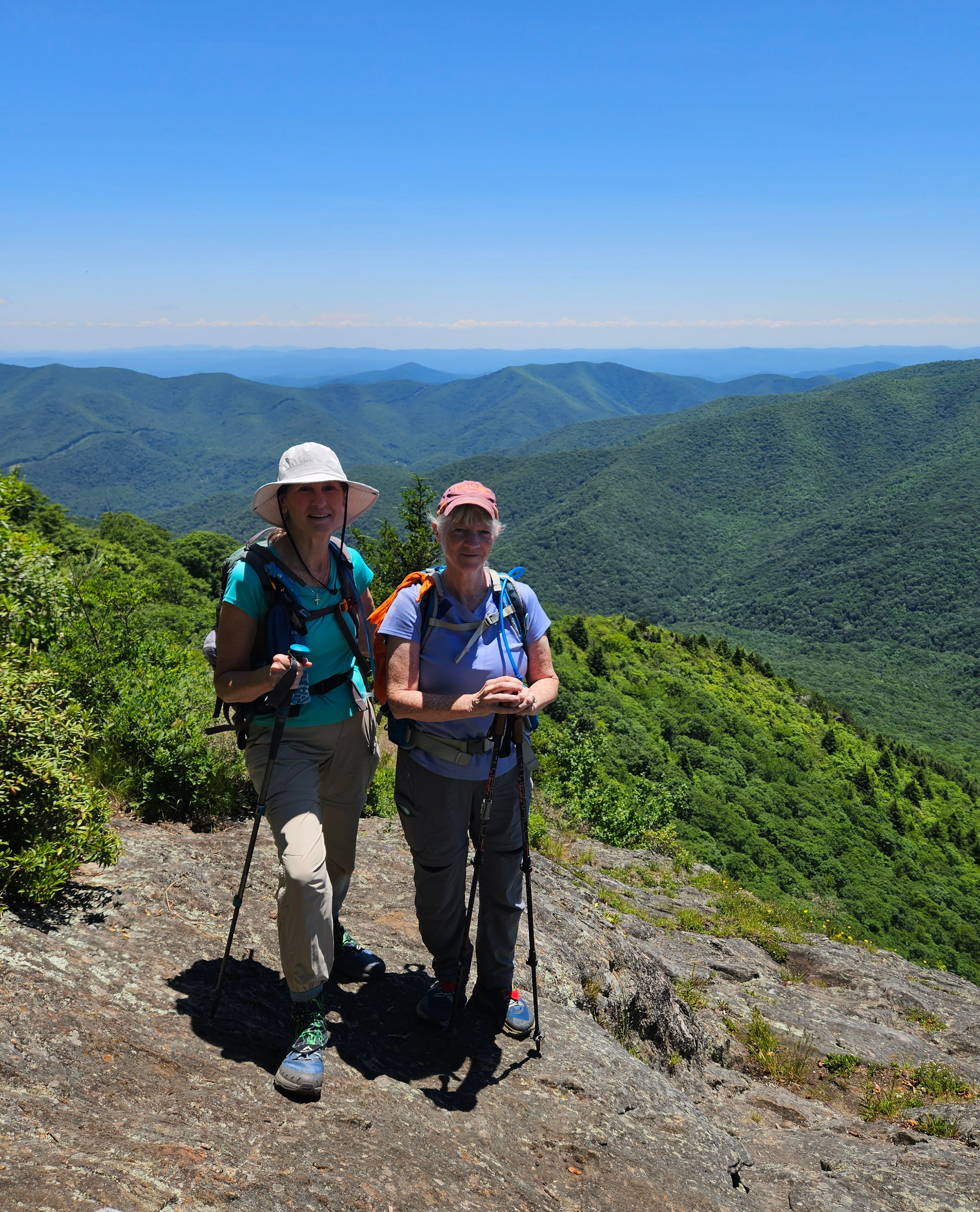
Yes, it’s the Cold Mountain (elevation 6,030 feet) that is part of the South Beyond 6000 Summit Challenge (SB6K).  

Raising the awesomeness factor of today’s hike is the Art Loeb Trail, a challenging route traversing ridgelines of Shining Rock Wilderness and high points of Pisgah National Forest. Camp Daniel Boone is at the northern terminus of the Art Loeb Trail. The southern terminus is 30.1 miles away at Davidson River Campground in Pisgah National Forest.

I’ve hiked all of the Art Loeb Trail except the westernmost four miles starting from the camp. I summitted Cold Mountain in 2009 as part of the SB6K Challenge (that’s 14 years ago, friends). Our trek on that day was a rigorous 18 miles out-and-back from…well, you can read all about it here.

Today’s adventure is all new for Carol, so let’s go!

It’s one heck of a drive from Mount Pisgah Campground to Camp Daniel Boone, and I was taken aback when it appeared we would drive through the middle of the camp while the morning flag ceremony was being conducted. Boy Scouts young and old swarming everywhere – are we in the right place? Yep, just keep going to the gravel parking lot for Art Loeb Trail.

A young woman with a loaded backpack was studying the trailhead sign and she headed up the trail a few minutes ahead of us. We soon caught up with her and she was eager to chat. She was excited to begin a birthday challenge for herself, her first multi-day hike.

Carol and I surreptitiously raised eyebrows. We are both experienced backpacking know-it-alls and Shining Rock Wilderness is quite rugged, a myriad of unmarked animal and social trails with no signage. We suppressed the urge to grill her about gear, instead encouraging her that it was very doable. She said she had paper maps and some info from the AllTrails app, figured she would take 5 days or so. We took a group photo, and Carol and I wished her well and walked on, a little worried – yes, judging her (lack of?) preparedness.

Our superiority complexes were quickly squelched as the steepness of the trail in front of us took our breath away. Let’s slow down and appreciate nature. Lush foliage and midsummer flowers were putting on a show!


I do not know what this is...

Dutchman’s Pipe vines and heart-shaped foliage

Turk’s Cap Lily

Carol crossing one of several little streams

Fire Pinks


Sundrops

At about 4 miles, we reached Deep Gap, where the Art Loeb Trail turns right and Cold Mountain Trail turns left. We took a break to assess our energy levels.

Are we having fun yet? Carol debated whether she wanted to continue to the summit.  Up to this point, the Art Loeb had been challenging but not hard to follow, clear of obstacles. Looking at the head-high foliage pointing towards Cold Mountain, though, I also had doubts. This is where the “let’s start, see what it’s like, maybe turn around” philosophy applies. (Spoiler alert at the top of this post: we both made it to the summit.)

Can you see me?

The steep grade didn’t let up. The closer we got to the top, the more rugged the trail became. The tall undergrowth persisted, broken up occasionally by boulders. No surprise I only took three photos on this section.

A piped spring

Columbine

I see an opening…

The top of Cold Mountain is broad, mostly tree covered, but there is a survey marker

Several expanses of rock facing south, overlooking Shining Rock Wilderness’s green carpeted ridges. Like Goldilocks, we checked out all of them.

The Art Loeb Trail follows the ridgeline in the center of the photo

On the return hike, we stopped at Deep Gap again where a group of high school age Boy Scouts were setting up tents. We chatted with the woman who was guiding them on a 3-day backpack trip in Shining Rock Wilderness. We asked about the young woman on her Art Loeb birthday quest, but this group had not seen her.

Most folks who meet in the middle of the woods are happy to talk: where ya been,
where ya going?

Further down the trail, we met two men and asked if they had seen the young woman. They said yes, she was turning around, decided it was too much for her. She could have modified her plan to a one-nighter out-and-back, but at any rate, Carol and I were very happy to hear she had made a thoughtful decision.

Heck of a long drive back to Mount Pisgah Campground with plans for a simple dehydrated supper. At the neighboring campsite, two guys were cooking something that smelled delicious and they invited us to “sit a spell.” They were old friends who meet several times a year to camp together, cook a lot, smoke cigars, enjoy the peace and quiet of the outdoors. Their setup was elaborate, with a huge tent and canopies, camp cots and a large rug to keep the dirt out – and don’t forget the eternal campfire. We talked about what we’d done that day and they talked about what they might do tomorrow, after sleeping in and cooking breakfast and smoking more cigars.

Camp neighbors keeping their priorities straight

"Live your life by a compass, not a clock."
 ~Stephen Covey


Sunday, July 12, 2009

Cold Mountain

Shining Rock Wilderness - 6/6/09 - Art Loeb Trail/Cold Mountain Trail/Art Loeb Trail/Ivestor Gap Trail – 18.2 Miles

My hiking group in Charlotte, the Carolina Berg Wanderers, posted a hike to Cold Mountain and I eagerly signed myself up. Have you all read the book or at least seen the movie? Cold Mountain has a mythic appeal here in the Carolinas. It is in the Shining Rock Wilderness section of the Pisgah Ranger District, a place known for its extensive grassy balds and unmarked trails. One of my favorite webcams is mounted on top of Mt. Pisgah and looks at Cold Mountain – I check it out on days when I’m stuck here in the flatlands and want to daydream.

There are a couple of approaches to Cold Mountain. In the words of Tina Turner, we could take it “easy” or we could take it “rough.” What do the Bergs do? Rough, baby! The hike was billed as strenuous, fast-paced, warning, warning, warning. Jeff, the Pisgah guru, was the hike leader and I’d hiked with him quite a bit in the Smokies, so I knew that at least he wouldn’t leave me for dead. Seriously, I didn’t think I would have any trouble…but think again…

The trailhead is about a 3-hour drive, at the Black Balsam Parking area off of the Blue Ridge Parkway near MP 420. What an exhilerating feeling to be on the Parkway again and heading toward a hiking trail! The sky was a brilliant blue with some puffy white clouds and the parking lot was…kinda full. Looks like there will be many people wandering in the wilderness today.

 I believe there were nine people in our hiking group. I have trouble verifying this because we did not stay together for very long. We walked back down the road a quarter –mile and turned left to pick up the Art Loeb Trail which led us quickly up on top of the balds. Now, these are not the Smokies type balds where you can see trees on all sides of a field. The grass covered peak after peak and we could see the Art Loeb stretching up and over the rolling mountaintops. Walking over the balds doesn’t even feel like hiking – it feels like a lovely jaunt in Ireland.

I love this photo of Jeff on top of one of the numerous rock out- croppings. I call it his “Super Hero” poster.

As I said, part of the attraction of this hike was Cold Mountain (which happens to be part of the SB6K challenge that I am still not officially hiking) but the hike also summited three other SB6K peaks: Black Balsam Knob, Tennent Mountain and Grassy Cove Top.

After Grassy Cove Top we passed through Flower Gap and topped Flower Knob. I think this is where the jackrabbits of the group took off and we did not see them again until we were atop Cold Mountain.

Trails in wilderness areas are not maintained like those in national parks and signage is minimal. At one particular intersection you really need a compass or a knowledgeable hiking buddy to determine which way to continue. Jeff showed us a clue: someone had marked this small white rock to continue on the Art Loeb. But I wouldn’t have even seen the rock on the ground if he hadn’t pointed it out!

After Shining Rock Gap (we came close but did not summit the real Shining Rock – saving some fun for another day) we were into the woods again and began climbing Stairs Mountain. Notice I did not say “Down” Stairs Mountain…The going got tough here and I seemed to be slower than I remember from the Smokies days. Is it possible to get soft so quickly?

Shining Rock Ledge gave a short respite and the occasional nice view – and then we were negotiating the Narrows. The footing was rocky and there was a little scrambling going on. Still, we managed to spot some wildflowers along this section, including pink ladyslippers and a glorious stand of yellow ladyslippers.

 Finally we reached Deep Gap and the intersection with the “easy” route to Cold Mountain (in this case “easier” just means shorter.) The fast half of the group did not wait for us here, which frustrated me and made me feel that I needed to rush to catch them. I had this feeling for most of the day and only partially convinced myself that I did not need to feel a push and it was their business how fast or slow they wanted to move. Still, a little advance communication and agreement would have been helpful. I just kept muttering to myself, “You’ve got the car keys in your pocket.”

The climb up Cold Mountain was steep and vegetation was overtaking the trail in many places. Often we could not see our feet and hoped that we were not stepping off into the wild blue yonder – or on a wild creature. (FYI for wilderness first aid people, at some point Carolyn suffered a scrape and she stopped the bleeding with a leaf.)

We met perhaps a dozen hikers on this mile-and-a-half section and spotted three nice primitive campsites. Near the summit we met the rest of our group…heading back down! But they were looking for a good resting spot and we would meet them after we tagged the top and took photos.


And here is the view from our lunch break. You can trace the ridge that we walked along all the way out to the horizon. I was so proud to achieve this goal and gazing out on it was awesome.

But we have to backtrack now? Yikes! The steepness going back down Cold Mountain was a knee-breaker and I was getting concerned that I was so slow. Of course the jackrabbits were long gone. Most shocking was the climb back up the Narrows – did someone crank up the lungbuster dial? I just didn’t remember this part being so strenuous. I was determined not to be last in line because I was a bit afraid to be left behind and I was unsure of the intersections, plus we were going to steer right at some point and pick up the Ivestor Gap Trail and I didn’t know where. Note to self: You are not in the Smokies anymore. Bring your own map and understand it before you start!

Jeff is a good friend, and although he could have hiked up front with the big dogs, he stayed near the back of the pack with us and we pretended to identify flowers as I frequently paused to gasp for air. I had my first sighting of a jack-in-the-pulpit. They are rather tiny and greenish and blend in very well, so I was tickled to find them.

The Ivestor Gap Trail is a road bed, very little grade, and although it was not as sexy as walking over the balds, I was glad to follow it the rest of the way. I was a whipped puppy when I finally got my boots off and had mixed emotions. I was happy to have summitted four SB6K peaks (not that I’m counting) but I was discouraged that I felt so beat up after an 18-mile hike. I guess it wasn’t so bad when you consider that we did it in about 9 hours…

 We all stopped for a late dinner and then said our goodbyes in the parking lot. I told the jackrabbits that I was sorry about not getting to hike with them and that I would probably never see them on a trail. Although I said it with a laugh, I was making mental notes about future hikes.

From there I was not going back to Charlotte – no, I had another hike planned for the next morning! I drove to Danny and Lenny Bernstein’s house in Asheville and rang their doorbell at about 10:00 p.m. (yes, they were expecting me). They took one look at me and said, “See you in the morning,” and I headed for my room-away-from-home. But first Lenny said something like, “How about those Narrows, huh? You’re not in the Smokies anymore!”

Somehow that remark finally validated how difficult the day had been – it wasn’t just me going soft, it was a dadgum strenuous hike! I slept like a ton of bricks.