
Appalachian Trail in VA Project – 2/22/14 – US 11 to VA 42 –
11.8 Miles

The back roads of southwest Virginia continue to incentivize
Jim to help me with my AT hiking. Thank
goodness he likes biking in the cold since so far Winter 2014 has been
relentless.
A brief two-day window of a precipitation-free forecast was
all it took to coax us out once again.
At the end of 2013 I had completed roughly the middle third of the AT
from Shenandoah NP southward to Burke’s Garden, south of I-77. For this outing I planned to cover the
section from Burke’s Garden to I-81 – backwards, sort of. To maximize my daylight, I started from I-81
to hike northbound to the Trail’s crossing at VA 42. This 12-mile section goes from Great Valley up
over Gullion Mountain, down into Crawfish Valley, then back up again over Big Walker
Mountain and down into Rich Valley. Jim
planned to bike all over creation and end up at the same spot on VA 42.

Technically I started from the parking lot of The Barn Restaurant
on VA 11 and walked underneath I-81.
Clear blue skies, but colder than I expected. The AT entered an open field with a gentle
climb. I had been walking less than five
minutes when I heard a lot of barking and howling and, looking far across the
field, I saw a pack of hunting dogs and two hunters in blaze orange. Suddenly a deer jumped in front of me and ran
into the brush. Welcome to hunting
season – again. I took out my red rain
jacket and tied it on the outside of my pack.
[Later on I described this scene to someone who reasoned that the
hunters were probably bear hunting and would only shoot up into a tree after
the dogs had trapped one. If anyone
wants to weigh in on this theory, let me know.]

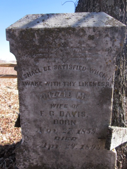
Headstone for Lizzie M. Davis, wife of F.G. Davis, died at
age 34. The inscription reads: “I shall be satisfied when I awake with Thy
likeness.”

After crossing VA 617 I found myself again in open
pastureland. In contrast to the deep green
of midsummer, it is still beautiful in winter, straw-colored grass, bare gray
branches of an old sentinel tree, deep blue sky minus summer’s haze.

Winter light

I negotiated nine fence stiles today, only half of which
were noted in my guidebook, crossing barbed wire fences that separate land ownership.

At a spot called Davis Path Camp- site, the remains of a
shelter taken down in 2008 “because of misuse." Camping is still allowed.

And the privy is still open for business.

A very pleasant gentle climb up Big Walker Mountain to
Tilson Gap, 900 feet elevation gain in 1.7 miles. Got to put some footprints in a little bit of
snow. Then what goes up must come down,
a little more steeply on the north side.

Walking a narrow stretch of the trail between two barbed
wire fences

At VA 610 I clambered over fence stiles on either side of the road and noted this friendly reminder to behave and be grateful as hikers are now entering a narrow corridor on private land. Instead of going straight up the hill, the trail meandered through the meadow before entering the woods again.

After one last small downhill I encountered yet another
stile at the North Branch of the Holston RIver, which was flowing at its fullest capacity. Fast moving water is
mesmerizing, don’t you think? In a few
hundred yards I came to VA 742 and the low-water Holston River Bridge, a concrete
crossing level with the pavement. The water
was lapping onto the bridge, threatening to spill over.

From the bridge I got an eyeful of Tilson’s Mill, built
before the Civil War. The building is
massive and deteriorating and spooky. I’ve
read that trail volunteers are working to stabilize the structure and document
its history and I look forward to learning more about it. Right now there isn’t much information on the
web.

Tilson’s Mill
According to the map, one more mile to go, but I question
that it is longer, through another pasture, a few ups-and-downs, and at long
last I stepped out onto VA 42 where reliable Jim was waiting. I am so happy that we have found a way to
share these adventures.
On our way back to our hotel room in Marion, VA, we stopped to
check out Hungry Mother State Park, nice little cabins, lakefront with swimming,
a conference center, picnic areas and an extensive trail system. If
the temps ever get out of the 20’s at night I would like to camp there, perhaps
as a base camp when I can help the next hiker complete this section of the
AT.
How did the park get its name? The traditional story that park rangers tell
is that the hungry mother is Molly Marley, a victim of a Native American raid
on a Virginia settlement. Marley and her child were taken captive, but they
escaped into the woods, surviving for many days by eating berries. Ultimately
Molly collapsed and died. Her child was found, crying "Hungry
mother." The child led them to Molly's body.
No comments:
Post a Comment