Monday, June 29, 2020

Pembrokeshire Coast Path - Day 8: Visit to Dale "Day Off"


Pembrokeshire Coast Path Day 8 – Marloes to Dale Round Trip “Day Off” 
8/10/19 – 5 miles


[If this reads like a diary entry full of personal details – it is! Some info may be helpful to someone planning a similar trip, there’s an abundance of photos because everything was so beautiful, and I believe food and drink and human connections are the secret sauce of traveling. As they say, “Take what you need and leave the rest.” Enjoy!]  

Every day so far we have merely observed low tides and high tides, but tomorrow's tides will affect mileage. To take advantage of low tide (and shorter miles) at two locations in the morning hours, Danny and I had previously agreed to skip the miles circumnavigating the Dale Peninsula. Considering the continued storm conditions, it wasn’t wise in any case to hike on the cliffs in extreme winds like we had experienced yesterday even if we'd had the time.  I may have said, “Hell no, I won’t go!”  Danny’s excursion to Skomar was canceled but she wasn’t going to sit around. She suggested walking into Dale Village to scout our starting point for tomorrow.

With walking directions from our host to “go between these two buildings, turn left at the end of the path, then turn right, cross the airfield and go down the hill,” we went looking for Dale.

[Airfield, did you say? Built and operated as RAF (Royal Air Force) Dale during the Second World War, then used for training by the Royal Navy as RNAS Dale (HMS Goldcrest), the land is now privately owned by a farmer. Neglected concrete runways and roadways and some buildings remain.]

Where are we going? The map below is Dale Peninsula. Marloes is above the top edge of the map. We plan to walk southward through the airfield (the dashed lines forming a triangle) and then somewhere near Westdale Bay we should turn eastward toward Dale, on the eastern (right side) edge of the peninsula – we’re walking across the “neck” of the peninsula. Sound familiar?

Where are we NOT going? Around the perimeter of Dale Peninsula, including St. Ann’s Head

A kind local woman said we're on the right track

Rain was intermittent and the high hedges along the narrow paved roads shielded us from the wind until we arrived at the airfield. Stepping out into the open, I was nearly knocked over.  I mean leaning-forward-just-to-stay-upright wind. I mean cursing-out-loud-but-the-words-are-carried-away wind. The airfield was massive, stretching to the horizon. The frog signposts were gone. We followed a deteriorated concrete roadway, hoping that at least an obvious left turn toward the town would appear. [No helpful P’shire signs today.]


Well, there was an obvious left turn, i.e. the concrete roadway ended at the cliffs. We followed another concrete roadway along the southern edge of the airfield, now walking perpendicular to the wind that continued at gale force. At last, stairs and a dirt path dropped us down into the narrow valley.

Frothy surf at Westdale Bay

Stormy skies over the village

The road through the valley passes between a row of colorful houses on the right and Dale Castle on the left.  A structure was first built on the site in the 13th century, but the “castle” that stands today is a private home remodeled in the early 1900’s (not open to the public). Some red sandstone walls, remnants of an earlier time, still stand alongside the path. (Read more here.)


The village seemed to be taking the day off, not many people on the beach and few boats in use at the port. Danny was focused on the start point for tomorrow. I opted to poke around the waterfront shops: one artists’ co-op and one gift shop. I sat down outside the Boathouse Café where exciting things were happening. 


An adorable Corgi brought his people to the café, but in his opinion, they left him outside for too long. He could see them through the window, enjoying their lunch. His antics to draw their attention, jumping and barking and begging, continued nonstop until they returned to him. How can you be mad at a cutie with such short legs? What might have been annoying if I was also trying to eat was instead entertaining as I had nothing else to do. This fellow was my favorite part of Day 8.

A family from Austria, a mother and three teenagers, arrived with fully loaded backpacks.  They were hiking the P’shire northbound, camping all the way. I didn’t envy pitching a tent in 
stormy conditions and blustery winds.

I walked out on the pier and then parked on a bench to watch whatever happened next.


Meanwhile, Danny walked a busy road section to locate the Pickleridge car park and satisfied herself on where we needed to go in the morning.  [More on her extensive research for tomorrow’s challenge coming up.] She found me still sitting on the bench by the water.

After a cup of coffee (no flat whites here, thank you) we headed back to Marloes. The wind was no less brutal and I was no less frustrated with struggling against it. We got sidetracked onto a runway (doesn’t all cracked and weed-ridden concrete look the same?) until I referred back to my photo of the right path with a fence running alongside it, and we corrected course. The one-mile distance that our host had described actually clocked in at 2.5 miles – each way.

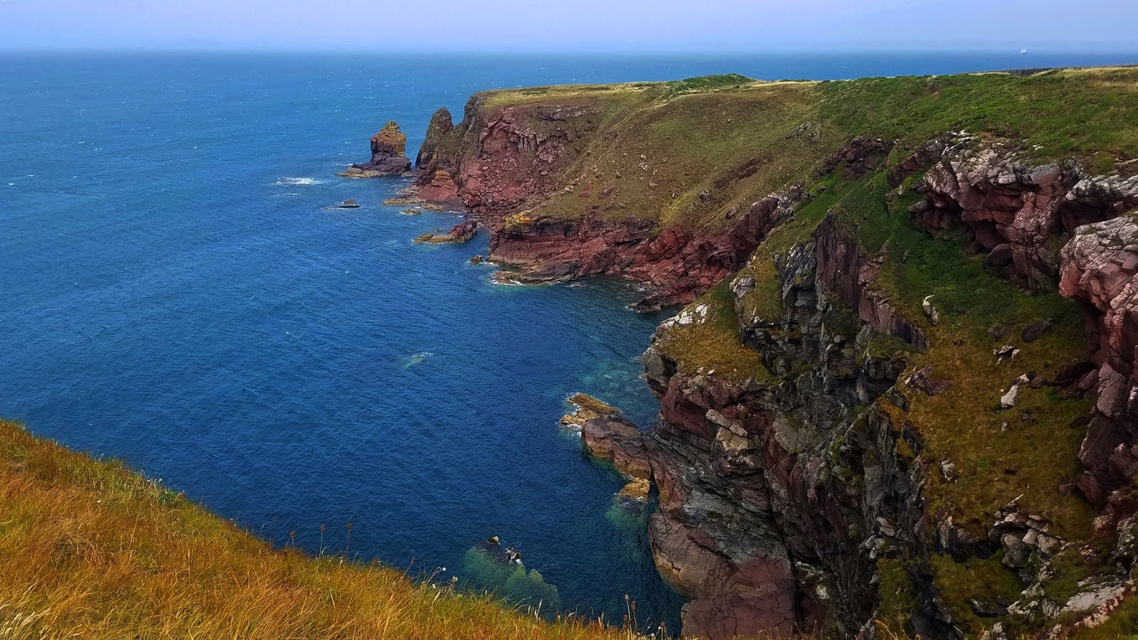
View from the airfield looking back up the coast to Tower Point, hazy on the horizon

Return walk to Marloes

We arrived at the Clock House around 2:00 p.m. and spent the remainder of the afternoon reading, writing and resting. Supper was back at the Lobster Pot, toasting to my least favorite day so far (fortunately, it all got better from there). Hiking mostly requires the right attitude, but sometimes poor weather gets the best of me. If I could do it over, what would I do differently? Something to ponder.

Tomorrow is a new day and an exciting new challenge – racing against the tides at The Gann and Sandy Haven.


Listen to the wind blow
Where does the wind go?
What does the wind know?
Listen to the wind blow. ~Buffy Sainte-Marie

Monday, June 22, 2020

Pembrokeshire Coast Path - Day 7: Broad Haven to Marloes

Pembrokeshire Coast Path Day 7: Broad Haven to Marloes - 8/9/19
13.5 Miles - 3000 ft. gain


[If this reads like a diary entry full of personal details – it is! Some info may be helpful to someone planning a similar trip, there’s an abundance of photos because everything was so beautiful, and I believe food and drink and human connections are the secret sauce of traveling. As they say, “Take what you need and leave the rest.” Enjoy!] 

With a cheery “Good morning!” a woman in her bathrobe entered the hotel breakfast room carrying a teapot and a French coffee press. Helen (the owner) had been away yesterday when we arrived and had only just been made aware of our request for an early breakfast. She gracefully pulled together cereal, toast, yogurt and fruit while we discussed last night’s storms and today’s windy and rainy forecast. Stepping outside, I was surprised to see the sky lightening up and the temperature not as cold as I expected.

Tonight Danny and I will walk along the southernmost coast of St. Bride’s Bay and stay at the inland town of Marloes. We have two options to leave the P'shire to reach it. The weather may be a factor in the decision, so we’ve studied walking instructions provided by Contour Holidays to make sure we understand the exit points. At least we’re on our own timeline today, not meeting a prearranged taxi.

By the time we walked the first half-mile to Little Haven, the sky had regressed to its typical flat gray morning doldrums and gave few clues of what awaited us; just be prepared as usual. Little Haven, a tiny town with a sense of humor, was still asleep.

A cup of tea and two front row seats

Goodbye, Little Haven

We walked half a mile through the coastal slope woodlands of Goultrop Woods, reminiscent of walking in the forests back home, except there one doesn’t step out of the trees onto a beach. As the P'shire continues southbound in the days ahead, we’ll enjoy many short diversions into fern-filled woods.


Threatening clouds increased and began to spit rain, quickly turning to a downpour. Danny and I stopped to make serious preparations, buried cameras in our backpacks, even put on rain pants (after all, we’ve carried them this far). 


Literally three minutes later, the sun came out and the rain pants came off. We decided we’d rather just get wet if the rain returned (which it did).

What’s that buzzing noise coming up over the hill?  It’s one of our trail maintainer friends from the National Park Service again! He said he prefers to work in the rain because there is less pollen and less people.

Aware that there are more remnants of the Iron Age and other eras in history than we could absorb, it was sometimes hard to discern what was truly an artifact and what was just…art.  This curious piece on a lonely promontory was created and placed by sculptor Alain Ayers as part of a series titled “Eyes of the Sea.” They say you can look through the hole to see Stack Rocks on the horizon.

Meanwhile, directly behind us – does that look like a funnel cloud to you?

Walking southbound on the P'shire, St. Bride’s Castle appears in the distance like Downton Abbey – I’m pretty sure I heard theme music playing and saw a yellow labrador retriever ambling toward the front door. The short story of this Baronial style mansion:  The original structure was built in 1811 and renovated several times. The Barons of Kensington expanded the estate and mansion from 1899 to 1920, when it had to be sold to pay death duties. From 1923 until the end of the Second World War the mansion, then called Kensington Hospital, served tuberculosis patients, and until 1978 it was a geriatric home. In 1992 the estate was converted to time-share holiday apartments  managed by Holiday Property Bond. Between us and the mansion lies St. Bride’s Haven, a lovely little cove of stunning hues (notice the return of blue sky!)


Cliff’s Cottage sits on the edge of the cove across from the castle – yes, you can rent the cottage! We chatted with this week’s tenant, then took our lunch break on the rocks. The tide was about halfway out.


At the head of the cove is St. Bride’s Church (we didn’t go inside). It is dedicated to St. Brigid (Bridget) of Ireland. Built in the 13th century, restored in the 1850’s, still an active parish.


The P'shire approaches the “lawn” of St. Bride’s Estate, getting my hopes up that we'll walk close to the manor, but abruptly and rather coldly it turns to the right and runs along the outside edge of the massive stone wall that surrounds it. The trail was pleasantly level and undulating, effortless walking, more than a mile to go around the westernmost half of the estate. The wall was tall enough, of course, to obstruct view so I contented myself with the flora and fauna that cling to it.

Water droplets emphasize an intricate spider’s web

Buttresses in the stone wall

Looking back at Tower Point, the site of an Iron Age promontory fort just outside the furthest back corner of the estate wall. Excavation in 1970 revealed a circular stone hut with a single entrance and a hearth. At this rocky headland called Nab Head (not visible in the photo), evidence has been found of Mesolithic peoples occupying the area 10,000 years ago. At this point the coastline and the P'shire turn sharply southward.


The walking was still easy and perhaps we were in denial of the darkening sky and increasing winds. Our first possible exit point to Marloes appeared at Musselwick Sands, but we decided we didn’t need to take it. Our sights were set on Martin’s Haven, where we hoped there was a coffee shop where we could pause and assess.  Martin’s Haven is the ticket office and departure point for Skomer Island tours.


We interrupt this blog post for a commercial about Skomer Island.

A major part of Danny’s itinerary for hiking the Pembrokeshire Coast Path was visiting Skomer Island, part of the Wildlife Trust of South and West Wales. Skomer Island is well known for its puffin colony and Manx shearwater seabirds. As this halfway point of our hike, Danny planned a day trip to the island. (I planned to spend that day off lying around, resting and eating, giving both of us a break from each other.)

During the two-mile hike from Musselwick Sands to Martin’s Haven, the rain moved in for good and the wind increased from breezy to blustery. On the plus side, I was tickled to find available toilets at the tiny port. There were a few vehicles in the car park, but the ticket office was closed up tight, displaying a sign that there were no boats to Skomer Island today or tomorrow. AND no coffee shop. Disappointed and famished from pushing past a reasonable lunch break, we sat on wet ground beside a parked car to block the stiff wind and eat an uninspired lunch. Nothing else to do but get back on the path.

[Because of the weather, we skipped Deer Park at the tip of the peninsula. Read about it here and here.]

A blurry horizon and choppy seas

Two more miles to our exit point at Marloe Sands. As the path returned us to the clifftops, the wind intensity ramped up to a gale. I wasn’t terrified, but I realized that this was serious business. I attempted to make a video but couldn’t hold the camera still and was afraid it would be knocked out of my hands. After a couple of photos of the pounding surf and spindrift (is the tide coming in or going out?), I stayed well away from the edges.  The wind was blowing inland with such ferocity that I felt unsteady on my feet, as though I could be knocked off balance. Maybe I wouldn’t be blown off the cliff, but I didn’t want to be blown any which way! Slow going.

Our exit point at Raggle Rocks – whew!

When we left the cliffs, the wind dissipated and we found ourselves walking on a nice footpath to a paved road as if nothing had happened. What’s that up ahead? 


Greatly refreshed with coffee and cake at Runwayskiln Coastal Cafe (part of an old farm from the 1500s, read about how it got its name) Danny and I followed our vague instructions to our B&B, navigating narrow roads and a frog-signed footpath for more than a mile (longer than expected) until we found the main street of Marloes.


The Clock House is a hotel-type establishment with a café on the ground floor, a comfy common area, and stocked with snacks and beverages on an honor system. Our bedroom was quite small but our en-suite bathroom was great, with a tiny in-between nook for shoes and backpacks.

Dinner at The Lobster Pot next door, a combination restaurant and bar and living room with couches. The place was bustling with locals and a tourist or two.

Belly up to the bar for your food and drink

Delectable meal, but you can keep the mushy peas, I cannot be converted

Cheers! Old Mout Cider – Berries & Cherries
Slowly but steadily bringing Danny over to the cider side.

During dinner I noticed a sign advertising Open Mic Night – tonight! – on the living room side of the room (15 feet from our table).  Signups were open for “anybody, any music style” beginning at 9:00 p.m. Danny wasn’t interested, but I thought it might be a nice diversion and a nod to my husband Jim: when we traveled together in the UK, we’d seek out local music everywhere we went.

When I returned to the Lobster Pot at about 9:30 p.m., the living room was crowded. I took the last available seat next to a friendly man and we exchanged pleasantries as a performer finished his set. The next thing I knew, the man next to me stood up, picked up a guitar that I hadn’t noticed, and walked over to the microphone! His first song was “Ghost of Tom Joad” by Bruce Springsteen (my favorite musician of all time, icon of my college years…but I digress.) I was dumbfounded. The next song was “Hello In There” by John Prine, another sensitive ballad. Certainly not what I had expected.

Then the roof blew off of the Lobster Pot as the performer launched into a fantastic rendition of  “Ring of Fire” a la Johnny Cash. He was talented in his own right, and everyone in the place joined in for the chorus – wow! The audience was clapping, whistling, shouting, not spilling their beer. My heart swelled at the universality of music, the lifting of spirits, the suspension of worries, the never-to-be-repeated moment in time there on a Friday night in Marloes, Pembrokeshire, Wales.  Open Mic Night in Marloes was my favorite part of Day 7.


“I fell into a burning ring of fire
I went down, down, down 
and the flames went higher
And it burns, burns, burns
The ring of fire, the ring of fire”
~June Carter Cash & Merle Kilgore