Thursday, October 28, 2021

AT in GA: Tesnatee Gap to Neel Gap

Appalachian Trail in GA – Tesnatee Gap to Neel Gap – 9/18/20 - 6 Miles

With cooler weather coming up, I turned my attention to closing my gap of the Georgia section of the Appalachian Trail. Just 3-4 days of hiking would get me to the southern terminus at Springer Mountain. It’s a long, long way from my home in Charlotte, NC, but I didn’t have enough days set aside to hike it in one go, so I divided the miles into two trips (yes, driving twice as much, but sometimes that’s just how it is.)

My hiking buddy Cathy, veteran of many adventures, had hiked this section long ago and was most recently working on completing the trail in the northern states. She’s always willing to help someone else, though, and joined me for two days in Georgia. We drove four hours to Neel Gap and poked our heads in at the Mountain Crossings store. I was disappointed to see that people there were definitely unconcerned about COVID – we were the only two people wearing masks, including employees and bikers and girlfriends. Didn’t stay long.

Since Cathy and I were traveling in one car, I arranged to meet a shuttle driver at 1:00 pm at Byron Reece trailhead to take us to Tesnatee Gap (no parking allowed at Mountain Crossings). The driver asked if we preferred that she wear a mask as we drove. Yes, thank you! So far there was one sensible person in Georgia.

From Tesnatee Gap we hiked 6 miles southbound back to Neel Gap. You’re thinking, “Well, dang, that’s a pretty short hike!” True, but we had planned around the four-hour drive and then setting up a campsite, so we didn’t want to stress about long miles.

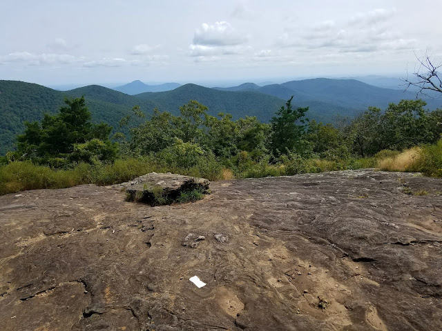
I was mentally stoked to knock out these miles on the magical AT and we had a beautiful day of easy hiking. Take a look:

Wolf Laurel Top, campsites with a view

Hammock Heaven for somebody

Cathy in the green tunnel

Downy lobelia

Goldenrod

Hello again, Mountain Crossings

The AT goes through the breezeway

A little ice cream celebration at a convenience store that had wifi

Reserving a campsite in the area was a challenge. The world had decided that outside was a good place to be during the pandemic (true) and October has always been a great time to be in the Georgia mountains. Vogel State Park was booked solid, but I scored a campsite at Lake Winfield Scott Campground. When we arrived at our site, though, a young couple with their dog were all set up there with a nice fire going. We said hello and politely explained that we had a reservation and my name was on the site tag. The poor guy guy had read the numbers wrong, but the good news was they did still have a site. We took a scenic drive around the campground area while they packed up. No hard feelings!

Cathy and I are pretty minimalist even when car camping, so the fire was a bonus for us. We’d brought Subway subs for lunch and dinner, so no fuss with cooking.  We sat at our picnic table, drank ciders, and enjoyed the fire glow. When we went to the bathhouse, it was pretty darn dark!

I pitched my 3-man Fly Creek backpacking tent by Big Agnes, very comfy and roomy, first time using it. (Yes, 3-man, so Jim and I can backpack together in comfort.) Cathy had her identical 2-man version, the very one that Jim and I used at Cumberland Island that I fell out of and broke the tent pole…but that is another story.

Sweet dreams indeed.

"I cannot make my days longer
so I strive to make them better.” 
~Henry David Thoreau


Monday, October 25, 2021

Smokies 900 Round 2: Forney Ridge & Forney Creek Loop Backpack - Day 3

Smokies 900 Round 2: Forney Ridge & Forney Creek Loop Backpack – Day 3
Springhouse Branch Trail/Forney Ridge Trail to Andrews Bald and Clingmans Dome Road 8/28/20 – 9.8 miles


My notes from this hike are mostly whining and moaning, only half a dozen photos, so I’ll put on my big girl panties and try to summarize:

Carol and I hiked in pouring rain from Campsite 71 to the Clingman’s Dome parking lot, a distance of 9.8 miles, a few flat spots, and nearly 5,000 feet elevation gain. It wasn’t pretty but we did it.

I didn’t eat enough to start out. At the intersection of Springhouse Branch Trail and Forney Ridge Trail, Carol handed me a piece of pita bread and a packet of tuna and I struggled to choke it down. I gagged on every small bite until I figured out that eating bits of dried apricot helped. The experience severed my relationship with tuna on the trail.

Not for the first time, I was grateful that our JMT trip had not worked out. The first part of that hike was supposed to be 8 days without a food resupply. How could I possibly have carried enough food to be able to…carry food? Circular impossible task.


Staying focused on Carol's blue rain cover as I put one foot in front of the other

Andrews Bald was socked in clouds and impossible to discern that it actually was a bald; it seemed more like a ridge with small open areas, not the expansive open fields and long range views that we knew were there. Two guys sitting on a rock said hello.


Andrews Bald

We took our last break at the intersection of Forney Ridge and Forney Creek Trail, and from there the psychological light at the end of the tunnel pulled me up the last mile. In total, the hike was 6.5 hours including all stops, much faster than the 7-8 hours I was anticipating. Must have been doing something right after all.

At the parking lot, two guys asked for a ride. They were attempting to run the AT section from Fontana Dam to Newfound Gap, but they decided to call it quits because of the poor conditions. We all had masks, so we drove them to their car at Newfound Gap. It lifted our own spirits to be trail angels after a hard day.

Another backpacking trip in the Great Smoky Mountains that kicked my butt,
and I’m sure we’ll be back again

Epilogue: Dairy Queen!

“Because in the end, you won’t rememberthe time you spent working in the office
or mowing your lawn.
Climb that goddamn mountain.”
~Jack Kerouac


Saturday, October 23, 2021

Smokies 900 Round 2: Forney Ridge & Forney Creek Loop Backpack - Day 2

Smokies 900 Round 2: Forney Ridge & Forney Creek Loop Backpack - Day 2
Jonas Creek Trail/Forney Creek to Springhouse Branch & White Oak Branch/Campsite 71  8/27/20 – 12 miles

As predicted, my hiking clothes were more than just damp, with no choice but to put them on. They quickly dried with my body heat, then got wet again with sweat. Summer hiking in the Smokies…

The first segment of today’s plan was a little 8-mile out-and-back hike on Jonas Creek Trail to the junction with Welch Ridge Trail. After that, we were moving to another campsite. Even though our tents were still wet, Carol and I took them down because we needed our hiking poles (which double as tent poles.). We put everything unnecessary for the out-and-back onto the blue tarp and rolled it up like a burrito to protect it from rain.


For the strenuous four-mile climb (2,200 feet elevation gain), we started off skipping with our light loads. Expecting four wet creek crossings within the first mile, we wore our Crocs and merrily splashed through the water. After the fourth crossing, we put our boots on, rounded a curve and hit a fifth one – boots off, Crocs on, walk across, Crocs off, boots back on. 


Coyote print?

Indian cucumber root (lily family) 

Doll’s-eye


Hey, Carol, are we done yet?

The morning was pleasant, still no rain but plenty of humidity, which meant it’s fungi time. Shout out if I have misidentified any of these beauties:

White marasmiellus

White worm coral

Golden fairy club

Turkey tail

Chanterelle

Chanterelle

Short-stemmed russula

The last 2 miles were slower, steeper elevation, and I began to flag. Is it not enough water intake, not enough food intake, or the heat that hits me so hard?  The heat has got to be the major factor. I can’t remember ever bonking on a cold day. Carol says I get “hangry.”

Dozens of yellow fringed orchids lining the trail like flags on the last half-mile

At the intersection with Welch Ridge Trail, a sit-down for food and a well-deserved rest 

During our break, along came a solo dayhiker who had recently finished his first Smokies 900 and was inspired for a second go-round. After a little chit-chat, he went on his way. Carol and I sailed back down Jonas Creek Trail in a dream state, five sweet creek crossings and no sore knees. 

Fraiser magnolia fruit

Back at the campsite, Carol and I unwrapped the blue burrito, loaded everything up, and shouldered our packs. We hiked a mere 1.2 miles further down Forney Creek Trail to Campsite 71, our home for tonight, at the intersection with Springhouse Branch. Along this mile, the trail follows close beside the creek except for one bump that veers away to avoid a steep bank. 

Could it get any greener?

Campsite 71 (called CCC) is another enormous horse camp with several fire rings and sets of bear cables and a beautifully preserved stacked stone chimney featuring a fireplace with a brick surround. This was once the location of the Bee Gum CCC Camp. The “brown book” describes the chimney and other artifacts in the area, but we didn’t spend much time exploring. We had a little more hiking on the agenda.

We pitched our still-wet tents near one corner of the site to leave room if a big horse group arrived (none did). We hung our food bags on the bear cables. We left the rest of our gear, including backpacks, inside our tent and carried only our rain jackets and water bottles as we continued another 1.3 miles on Forney Creek Trail to the junction with White Oak Branch Trail (to connect those dots as part of the Smokies 900). Then we turned around and retraced our steps to Campsite 71. Moving light as butterflies on a mostly level trail, we completed the 2.6-mile round trip in an hour. 

The goal of base camping is hauling fully loaded backpacks as short a distance as possible.
For a 12-mile day, we carried loaded packs for just 1.2 miles. Base camping for the win!


It was now 4:30 pm, a rare thing to be in camp so early with lots of time to relax. Forney Creek flowed noisily on the far side of the trail. We filtered water and decided that there was enough privacy for both of us to take a bath in the creek. I found a little side pool tucked under the rhododendron and stripped down to underwear and washed with a bandanna – so refreshing!

We set short clotheslines to hang the day’s wet clothes and settled down to boil water for supper. This time I managed my Jetboil like a boss. Checking on my remaining food, I saw that I didn’t have much. I added water to the oatmeal packet I had prepared for overnight soaking - quick oats, freeze dried blueberries, and a packet of coconut oil.


We were in our tents before it got fully dark, a good tired, reading a little bit by Kindle-light before falling asleep (my current book is Dear Bob and Sue.) Like the previous night, the roaring creek drowned out any noises of bears and people and things that go bump in the night.

"The wise man knows that it is better
to sit on the banks of a remote mountain stream
than to be emperor of the whole world."
~Zhuangzi