Showing posts with label Terlingua TX. Show all posts

Thursday, November 3, 2022

Big Bend National Park: Lost Mine Trail & More Cowbell

Big Bend National Park: Lost Mine Trail, Window View Trail
 & More Cowbell (I Mean Terlingua)
 1/17/22 – 5.2 Miles
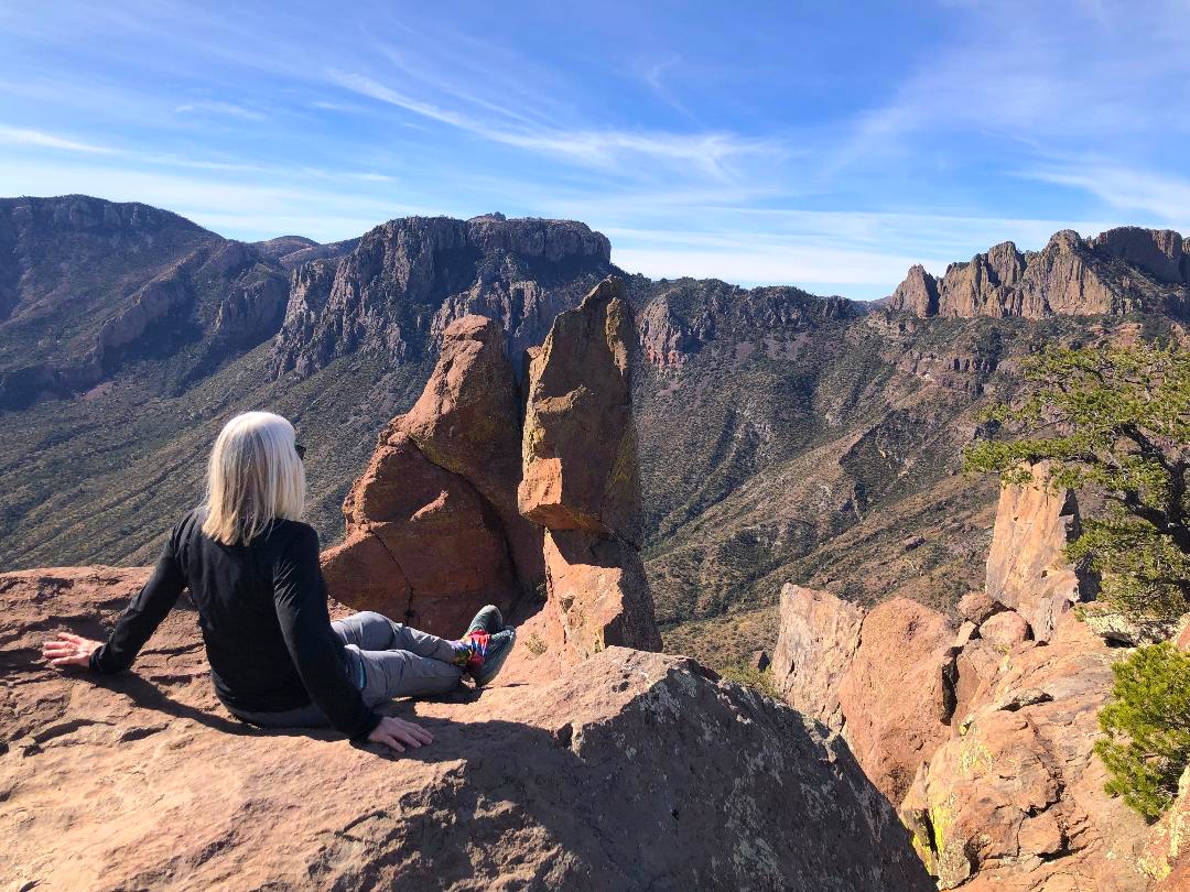
Emory Peak, Toll Mountain and Casa Grande Peak (L/R)

Groundhog Day: the long drive from Alpine to Big Bend NP again. This was our last day in this jewel of a park and we’re actually going hiking before we go home. We headed to Chisos Basin, the center of it all - a pile of mountains in the middle of surrounding flat desert - the highest peaks and the biggest views.

Emory Peak, the highest point, is 7,825 feet…but we’re not going up there. The shortest out-and-back trip to its summit is more than 10 miles. Rather than spend a whole day on one trail, we tackled a half-day hike in the neighborhood: Lost Mine Trail.

My mantra en route to trailheads and campgrounds: Please let there be an open space, please let there be an open space, please…

Lost Mine Trail is the most popular hike in Big Bend NP and there is limited trailhead parking. If it’s full, the alternatives are parking at Chisos Basin Visitor Center and walking the twisty-turny paved road back to the trailhead…or choose another hike. Perhaps we were in between the morning and afternoon waves on this Monday morning of Martin Luther King weekend. We got the last parking spot.

Trailhead sign and a reminder of who lives here

The name “Lost Mine Trail” can be misconstrued as climbing up Lost Mine Peak itself,
 but it actually climbs a ridge to a viewpoint of Lost Mine Peak to the east
 and Casa Grande Peak to the west

As we’ve learned to expect, we had a chilly start. There were not too many people on the trail, at least not by Great Smoky Mountains standards. The path was rocky, dusty and worn, but holding up well for the years since it was built by the Civilian Conservation Corps (CCC) in the early 1940’s.

We started out in an oak and pinyon pine forest with glimpses of what’s ahead

The trail climbs gradually along the base of Casa Grande Peak. About one mile in, it reaches a saddle where the view busts wide open.

Casa Grande Peak, totally dominating like a fortress on a mountaintop

Casa Grande Peak and its sidekick Toll Mountain

Looking south into Juniper Canyon and beyond

After reattaching our dropped jaws, we continued on as the trail turned left away from the peak views to climb long switchbacks to the ridge (quad workout!)

Check out the CCC stonework on the right edge

Changing perspective, looking northwest at Mount Huffman in the center,
Casa Grande on the left

The last few switchbacks were steep, rocky and exposed, requiring full attention on your feet unless you stand still to check the view, which I did about every ten steps. 

The last half-mile was a mostly level walk along the ridge (also exposed with steep drop-offs)

Trail’s end is a pile of house-sized boulders to climb around on for vantage points looking west across Juniper Canyon at Casa Grande Peak and Toll Mountain, and south to Mexico. To me, the Chisos Mountains resembled the Grand Tetons without snow.

Looking south, an unnamed rock pinnacle in the foreground, Elephant Tusk sticking up
 like a tooth on the middle horizon, Mexico on the far horizon

Disclaimer: I didn’t have a reference point for Lost Mine Peak but this is a photo looking
 in that direction from the ridge

We ate lunch sitting out on the rocks, chatting with a man who was very knowledgeable about the park. He lives in Virginia but had visited Big Bend a dozen times, feeling drawn to the vast, mystical, unknowable landscape.

As the afternoon swarm of peeps arrived, we retraced our steps. The air had warmed up and the hike back seemed to take longer than expected. As I walked I wondered, as I often do when exploring the natural wonders of this country, whether I would ever return to this trail. Felt grateful for this adventure with my family on a beautiful clear day.

At Chisos Basin Visitor Center we changed clothes and indulged in ice cream. Asked about visitation numbers, the ranger keeping count of folks coming in the door told us it was a slow week. Between Christmas and New Year’s they saw around 2,300 people per day, while today Laura was number 138. I was a bit surprised since this was a holiday weekend in cooler temperatures.

From the VC, we walked the quarter-mile Window View Trail, a nice way to wind down and change gears. So far, everyone else had seen a roadrunner except for me, and then one appeared in the parking lot!

We hadn’t had enough of Terlingua, so we drove west from Chisos Basin as we waved goodbye to Big Bend National Park. After a beer on the rooftop deck at High Sierra Bar & Grill, we took a walk around the ghost town’s self-guided tour of old buildings, some intact and some piles of rubble. I felt appreciation for the grit required to live through the town’s hey-day of mercury mining and later decline. Read more about Terlingua’s history here. Google will give you gobs of information about what to do there.

The most intriguing place in this scrappy town is the Terlingua Cemetery, at first glance a small collection of rough graves that deserves a closer look. It’s on the National Register of Historic Places.

Graves are arranged somewhat in row formation, covered by stones and dust and dirt, most facing east. Some are decorated poignantly with flowers, candles, coins and personal items. Some have makeshift crosses. Some are neglected. It seems a sobering place to be laid to rest, yet there is a sense of community and levity here. The cemetery has a following as a spiritual site.

Epitaph: "Not all who wander are lost"

Pay a visit, make a toast, leave the container

Some fancy new neighbors

We scratched the surface of this corner of Texas, realizing that it would take a lifetime to explore it all (don’t forget Big Bend State Park right beside it). Everything we packed into three days was worthwhile and we’ll count down the days until we can return.

“If a man’s from Texas, he’ll tell you.
 If he’s not, why embarrass him by asking?”
 ~John Gunther


Monday, October 10, 2022

Big Bend National Park: Ross Maxwell Scenic Drive & Santa Elena Canyon

Big Bend National Park: Ross Maxwell Scenic Drive & Santa Elena Canyon – 1/15/22

Well, Big Bend National Park is BIG. When you have only three full days to explore 801,200 acres, just go with the guidebooks and top 10 lists and pinkie swear you’ll return someday.

Back story: A visit to our daughter, Laura, and her fiancé, Zach, in San Antonio morphed into a road trip to Big Bend NP (first time for all of us). I was a bit late in looking for accommodations and we ended up with an Airbnb in Alpine, TX – a looooong drive in and out of the park each day. [Note: if you’re going, plan way ahead and if you don’t like the options inside the Park, shoot for the quirky town of Terlingua.]

We broke up the all-day drive from San Antonio to Alpine with a side trip to the Jersey Lilly Saloon in Langtry (Judge Roy Bean’s saloon/courtroom). 

At Alpine, we tossed our luggage and groceries into our Airbnb and hustled another half hour to Marfa, a small community with a big reputation as a quirky, artsy, foodie culture town. All I know is we found Marfa Spirit Co, which specializes in sotol (a unique liquor similar to tequila or mescal but distilled from the Dasylirion wheeleri plant). I am not sure what happened after that.

Toasting to everything sotol at Marfa Spirit Co.

So…this morning we were up very early headed to Big Bend. Zach was uber prepared with coolers, a picnic basket, Google maps and the day’s itinerary. [I brought along a hiking guidebook, Falcon Guides Hiking Big Bend National Park by Laurence Parent.] With Zach as our driver, I relaxed in the back seat and enjoyed the ride.

As the sun rose, the overwhelming magnitude of wide-open spaces began to sink in. The temperature was 31 degrees and the wind was fierce, as in “be careful opening car doors!”

Laura and Jim

We entered the park through Maverick Junction (thank you, NPS, for my senior lifetime pass). At the Castolon/Santa Elena Junction, we turned right onto Ross Maxwell Scenic Drive for our leisurely 30-mile drive to the Rio Grande. Stops along the way:

Stop #1: A half-mile walk to the site of Sam Nail Ranch

In the first five minutes on the trail, Jim stumbled with arms windmilling like a cartoon character and almost fell face first into a large bed of cactus.  Big spines penetrated his pants and embedded in in his legs, which he said were pretty darn painful. It was a scary moment because he could have been seriously injured. I think Laura was spooked…old parents, can’t take them anywhere…

OUCH!

A dry riverbed on the ranch property

Stop #2: Sotol Vista, a high lookout point with expansive views south and west to the Chisos Mountains and the Santa Elena Canyon cut in the mesa. The cold wind gusts increased and I was very glad I’d brought my puffy jacket. [Will these conditions continue all day?]

Sotol plant

Gotta love those NPS pit toilets

Stop #3: Homer Wilson Ranch site, a sheep and goat ranch (also known as the Blue Creek Ranch) in Blue Creek Valley. In total, Homer Wilson’s holdings included 45,000 acres in what is now Big Bend NP. Wilson died in 1943, his family moved away, and by 1945 the ranch sat abandoned.

The house that still stands at Blue Creek Ranch was occupied by the ranch foreman. It’s a half-mile walk down and across scenic bottom land, lush with cactus and other flowering plants.

Our chilly crew

As we neared the house, I noticed a pricking sensation in my left calf. My pants leg had somehow brushed up against a cactus and dozens of small needles penetrated through to my socks, and ultimately about a dozen went all the way through to imbed in my leg – painful! I had to zip off the pant leg to get at everything and kept finding spines here and there for the rest of the day. After that, we were hyper-sensitive to being stalked by cacti.

Front view of the house

Back view

Inside, the ceiling made of giant beams and reeds from the river,
floor of large stones from Blue Creek Canyon

Texas Gothic 1: Glassless Framed Windows

Texas Gothic 2: Desert Corral

Plant cacti

Human cacti

Continuing on Ross Maxwell Drive - Goat Mountain

Stop #4: Mule Ears Overlook is a half-mile mile spur road off of Ross Maxwell Drive and Mule Ears Trail begins at the parking area. The Mule Ears Peaks are very distinctive eroded rhyolite dikes that can be spotted from many points in the Park. Because of our limited time, we walked only about a quarter mile for a closer look and called it good.

Zooming in from far, far away

I do not remember what this is, but looks pretty cool, huh?

Stop #5: Castolon Visitor Center, featuring some well-preserved human history of Santa Elena Canyon when it was a cotton growing community of both U.S. and Mexican citizens. There are interpretive exhibits and several buildings to poke around in (although a 2019 fire did extensive damage to some).

[If you are going, check first, as Castolon is very remote and open only seasonally.]

Cotton farming machinery - Cerro Castellan in the background

Stop #6: Santa Elena Canyon Overlook, a stunning view of the mouth of Santa Elena Canyon carved by the Rio Grande River. The northern side of the canyon (on the right in the photo) is the United States border while the southern (left) side is the Mexico border at Parque Nacional Canon de Santa Elena. We stopped for a quick picnic lunch before driving on to the Canyon hike trailhead.

Laura checking out Santa Elena Canyon

Stop #7: Santa Elena Canyon Trail – The hike is a popular, easy 1.7 miles round trip beginning with a quarter-mile walk through vegetation we don’t see in North Carolina (mesquite, tamarisk, giant river cane). 

We popped out on the sandy edge of Terlingua Creek...wait a minute! Even reading the trail description ahead of time, I didn’t quite picture that we would first cross a branch of Terlingua Creek and then cross the wider confluence point where Terlingua Creek flows into the Rio Grande.

Zach removed his shoes and crossed barefoot, but the rest of us kept hiking shoes/boots on as we waded through the frigid water. What a memorable moment, putting my feet in the Rio Grande!

Halfway across, then turn towards the right bank to cross again

The trail quickly climbs above river level via several short switchbacks

Looking back towards the mouth of Santa Elena Canyon, bright sunshine on the
 Chihuahuan desert while the steep canyon walls create deep shadow

The trail continues on a shelf along the right-hand side of the river, taking us a half-mile around the bend and up the canyon. I saw kayakers paddling towards us, and I promised myself I would return someday to do an overnight float trip.

Jim and me at trail’s end

Repeating the water crossings on the hike back [are Laura and Jim walking on water?] It’s only
 3:30 pm but the shadows of the steep canyon walls make it look later.

Stop #8: Drove allllll the way back through the park to Terlingua, a one-of-a-kind town with many one-of-a-kind things to do, including dinner at the Starlight Theatre. [More exploration on another day.]

No reservations, just line up at 5:00 pm when they open the doors (we arrived at 4:30 pm). While we waited, we enjoyed adult beverages and started a conversation with three women sitting near the entrance, two sisters from Dallas and a friend from England. We swapped stories and big laughs (everything is bigger in Texas, remember?)

Before we knew it, we were seated and ordering antelope burgers – a great way to end a tremendous day in Big Bend National Park! (Oops, we still have a two-hour drive back to our place in Alpine…)

"At some point in life,
 the world's beauty becomes enough."
~Toni Morrison