Saturday, December 29, 2012

You Never Step In The Same River Twice


AT to Charlie’s Bunion/Sweat Heifer Creek Trail/Kephart Prong Trail – 10/5/12 - 12 Miles


Very excited this morning, anticipating a trifecta of my favorite things:  (1) hiking on a gorgeous fall day in the Great Smoky Mountains (2) with new friends who have never been to Charlie’s Bunion (3) plus a few extra miles on my own.  I must figure out a way to do this for a living. 

After breakfast this morning Christine, our GSMNP ranger-leader-friend for our Trails Forever volunteer week, treated us to a slide presentation she had created from our work week and gave each of us a DVD copy.  A great catalogue of memories of our unique experience!  After that, our group began to dissolve, a couple of people leaving for the long drive home, some hiking in different areas.  Sarah and Helen and I headed to Newfound Gap to check out the Appalachian Trail – Charlie’s Bunion, here we come! 

A beautiful beginning

The AT was busy, of course, because Charlie’s Bunion is one of the most popular and iconic points in the Park.  The hike is moderate, gradually gaining elevation, and in many places you can look down on both sides as though you are straddling a wide fence dividing North Carolina and Tennessee.  For many visitors this is the only place they set foot on the AT and not everyone makes it the four miles out to the Bunion (remember, it’s four miles back).  But every step of the way was a celebration for me.

Dog hobble showing its fall colors was the stand-out of the day

We passed Tina, Frieda and David along the way and caught up with the other Sarah from our work crew at Icewater Spring Shelter.  We had a leisurely lunch, enjoying the sunshine after work days in the rain, and the four of us pushed on to the Bunion.

Charlie’s Bunion is a magnificent rock bluff facing Tennessee, once sleeping underneath the typical Smokies soil and trees and then uncovered by two events:  a fire in 1925 that destroyed the vegetation followed by a particularly vicious cloudburst in 1929 that washed away the exposed soil.  A crew that included Horace Kephart and his friend Charlie Conner took a hike to check out the damage after the storm.  The story goes that when Charlie removed his boots and socks to tend to his sore feet, Kephart likened Charlie’s bunion to the rocky outcropping. 

Helen and I out on the farthest point of the Bunion

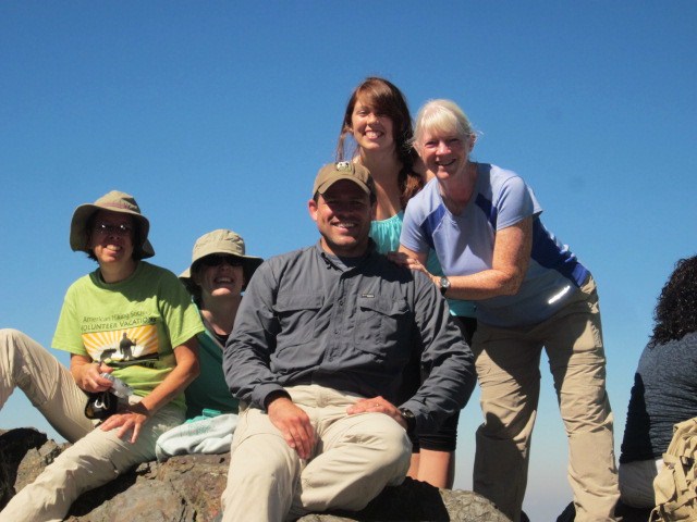
Our Trails Forever crew with a random guy from Atlanta.  He took photos of us first and we invited him to join in.  Loads of people at the Bunion today and we had to take turns to get pictures.

Mount LeConte, the second highest point of Tennessee and third highest point in the Smokies.

We left Charlie’s Bunion and began our backtrack on the AT.  My friends were hiking back to our starting point at Newfound Gap and I planned a longer route via Sweat Heifer Creek Trail and Kephart Prong Trail.  At Icewater Spring Shelter we parted ways.

The intersection of Sweat Heifer Creek Trail and the AT.  From here I’ve got about 3,000 feet of descent.  Hope my knees are ready for it!

I’ve hiked Sweat Heifer Creek Trail only once before, in the opposite direction, climbing up from Kephart Prong to the AT, so this excursion was a sweet treat indeed, in a different season and rolling downhill.  The previous hike was solo, cold and crunchy with snow and there was evidence that I had company ahead of me.  Never met them face-to-face, though.


The first quarter mile of trail appeared unloved, narrow and faint, but eventually it grew more distinct.  Purple asters, the last of the fall flowers, were hanging on. 


A very recent blowdown.  I had to suck in my belly to scoot around this one.

“Hiking Trails Of The Smokies,” aka the “brown book” contains descriptions of every trail in the GSMNP, but the write-up of this trail is surprisingly lacking.  At about the halfway point there is a sharp left turn (going downhill)at a gap where there are rusted buckets and other artifacts, perhaps evidence of a work crew from years long past.  There is no mention of this spot in the brown book. 

Soon after this point I heard a rush of water that grew louder and louder.  Funny, I didn’t make much note of water features on my prior hike.  I wonder why not?  The first cascade didn’t photograph well but was really beautiful in person, sparkling in the afternoon sun.  This is a tributary to Sweat Heifer Creek. 

The thick carpet of leaves crunched with each step and I made many attempts to photograph the trail at ground level.  How about if I blow this up to life size and hang it on the inside of my front door?  Then every time I leave home I’ll feel like I’m walking right into the Smokies.

Again, the increasing roar of water and this time it was the real thing, Sweat Heifer Cascades, where the creek tumbles across the trail, spilling from ledges into pools and forming more cascades.  This hike just kept getting better!  My heart was joyful.

Just before the junction with Kephart Prong Trail I reached a footbridge crossing Kephart Prong. 

I didn’t realize at the time how close I was to the intersection and the Kephart Shelter.  I sat on the bridge to have a snack and watch the ever-changing flow of water.  Paraphrasing a saying attributed to Heraclitus, “You can never step in the same river twice,” what does it mean for you?  Many interpretations.

A few steps later, I walked up to Kephart Shelter and chatted with the fellows who were stopping there for the night – oh, how I envied them!

The two-mile walk down Kephart Prong Trail went quickly and soon I was at my car, set to return to base camp for one last night with the trail crew.  This was a rare time when I was not ready to end my hike – I felt I could keep going for miles.  But the sun was going down soon and all good things must come to an end…until next time.

“Climb the mountains and get their good tidings. Nature’s peace will flow into you as sunshine flows into trees. The winds will blow their own freshness into you, and the storms their energy, while cares drop off like autumn leaves.”  ~John Muir


Thursday, December 13, 2012

Take A Volunteer Vacation - Chimney Tops Trail in the GSMNP


Smokies Trails Forever Volunteer Week – October 2012

I’ve often thought about a volunteer vacation, spending a week doing trail maintenance in some exotic location I’ve always wanted to visit, returning some of the good that has been granted to me on trails by those who went before me.  But what is expected of a trail volunteer?  Was I strong enough?  Hardy enough?  Willing to be cold, wet, and exhausted?  For several years I scrolled through American Hiking Society’s volunteer vacations listings, daydreaming about Alaska and Oregon.  What do these ratings mean, moderate, difficult, strenuous, very strenuous?  I didn’t want to just pick up trash or trim vegetation, but could I lift rocks or dig new trail? 

Looking over the 2012 trip descriptions, a familiar phrase caught my attention:  Great Smoky Mountains.  Now this is something I know a little about!  I was familiar with the terrain, the weather conditions, and I could add a day or two at the end of the week (if I wasn’t too exhausted) and hike a little bit in my favorite place on earth.  I had heard of the Trails Forever program that sponsored the work and knew the trail that the crew was rehabbing.  The work was described as moderate so I could probably handle it.  So let’s go on a volunteer vacation.

Our crew gathered together for introductions on a Sunday afternoon.  We had a volunteer crew leader (Tina) and a GSMNP park ranger (Christine) to guide us through the week.  There were 10 of us in the crew, some from as far away as California, a couple of us from North Carolina, and others from Tennessee, Maryland and Illinois.  A great group of like-minded folks and we bonded very well as the week progressed.  And I was so thrilled to be in the Smokies I couldn’t stop smiling.  


The GSMNP provided an established camping site for trail crews, complete with a covered shelter with picnic tables, a refrigerator, propane stoves, and secure food storage.  We even had access to a hot shower and a washer/dryer setup, very unusual for most volunteer vacations.  Every day we were transported between our camp and the work site.

Trails Forever is an endowment for a permanent work crew to perform major trail reconstruction throughout the Park.  Volunteer crews like ours supplement their work.    

The project for 2012 and 2013 is the Chimney Tops Trail, a very popular and heavily eroded two-mile trail.  During the work season the trail was closed to the public Mondays through Thursdays. 

Some of the incredible work done by the professional crew.  These steps were built with rock pulled from the creek.  Take time to look at this website to see what wonders have been wrought thus far on the Chimney Tops Trail.


Our daily routine consisted of getting up before daylight, taking turns cooking breakfast and cleaning up (Tina had purchased all the food ahead of time and supplied menus), packing personal lunches and snacks, riding to the trailhead and hiking a little less than a mile up to the work site.  After work we rode back to camp, took turns at the showers and washing clothes, cooking supper and cleaning up. 

Smokies weather played a big role in our work week.  On Day 1 we were humbled by rain and had to quit after a few hours because we were eroding the trail with our own footsteps.  On Day 2 we skipped trail work altogether because of the wet conditions and Christine gave us a little tour of the main part of the Park, including hiking on Forney Ridge Trail, the Trails Forever crew’s project for the last couple of years, and a stop at Newfound Gap.  Day 3 and 4 were work days.  Day 5 was a wrap-up and slide show of our adventures, and then we all went hiking.

Making lunches in the morning

Cleaning up after supper (side note:  these two won this "vacation" in a contest - they had never heard of the Great Smoky Mountains.  We are so glad they joined us!)

Someone doesn’t like mosquitos

Our commute to work was pretty beautiful

Here, have some tools

Digging trenches for water flow

Looks great so far but we're not done yet

Busting up rocks

If you break a mallet you get your picture taken

Frieda knows how to relax on a break

Nice cribbing constructed by the Trails Forever crew – now we get to fill it up with rocks

Good job – now cover them all with dirt from the trench we will dig alongside it

Looking good, girls

Standing on our completed section

Looks like it’s been this way a long time?  Nope, only about 15 minutes

In the evenings we strolled over to see the elk hanging out in the fields by Occonaluftee Visitor Center.  During the night we could hear this bad boy bugling at challengers.

The week was hard work, but not awful, and incredibly rewarding.  I learned so much about how a trail is constructed and will always look at rock steps, trenching and cribbing differently.  I am looking forward to many volunteer vacations in the future. 

It is amazing what you can accomplish if you do not care who gets the credit.  ~ Harry S. Truman


Thursday, November 29, 2012

Mount Elbert


Colorado Hut-to-Hut Adventure – Day 9 – 9/16/12 –Mount Elbert - 9 Miles

Our time in Glenwood Springs was so short that I believe I blinked and missed a lot.  A very early morning departure after too few hours of sleep and we were traveling eastward again, this time to put the cherry on top of our Colorado Sunday (get it?) – summiting Mount Elbert.  The popular North Mount Elbert Trail is 9 miles roundtrip and I wanted as much time as possible for the journey.  At 14,440 feet, the second highest peak in the lower 48 states, most people have never heard of Mount Elbert.   Colorado has 53 mountains over 14,000 feet high, and names like Pike’s Peak (14,114) and Longs Peak (14,255) are more famous.  But Mount Elbert was right in front of us, so here we go. 

Jeff gave us the details of his experience climbing this mountain:  trail more than half above tree line, not dangerous, not technical, some rock scrambling but no narrow edges from which to plummet (I beg to differ with this post-hike), “it gets really steep near the top,” and he did it without acclimatizing and was very slow.  Well, I now had 8 days of acclimation so I would be … very slow.  It was the 4,500 feet of ascent in 4.5 miles that sobered me up.  But I can do this.


Jeff’s trailhead for Mount Massive was a half-mile from ours.  Although he had more miles to complete his summit, he is pretty fast when he hikes solo and I knew he would be back at the parking lot before me.  Cathy and I were quickly ready to hit the trail so we started off, knowing that Mike would catch up to us soon enough. 

The first part of the hike is on the CDT and was surprisingly gentle.  At 1.4 miles the CDT continues straight and a right turn put us on the summit trail.  Soon after, Cathy was ready to pull ahead so we made a plan to meet up every hour.  When the trail got steeper I realized this was a mistake because Cathy would be spending a lot of time waiting for me.  Sure enough, I was 10 minutes behind her for the first stop, so we made a plan to meet one more time in another hour and see how far apart we were.  After that we would adjust or abandon plans and every hiker for him/herself.  Cathy started off again and I waited for Mike (10 minutes behind me). 

Here comes Mike (1)

At the tree line Mike wanted to stop for lunch.  I had very little appetite but ate a small snack.  I left Mike enjoying his hoagie, knowing he would catch up to me easily, and began my snail’s pace up the deceptive mountain.

That doesn’t look too hard, does it?

Jeff’s view of the Mount Elbert trail from his trail to Mount Massive

A brilliant blue sky, a few interesting clouds rolling through, a cold but comfortable temperature, a very light breeze, lots of people (after all, it was a Sunday) and very little oxygen:  almost perfect conditions for peakbagging a 14-er, right?  And yes, there are elementary school age children and their dogs on the trail.  I can do this.

One step at a time, don’t forget to look around once in a while, admire the scenery, look at the pretty rocks.  Every step was earned.  Are those people or ants above me?  It was impossible to guess distance according to my pace, but it looked like I was nearing the summit sooner than I had expected.  So I asked a guy descending, and he smiled kindly and said I was less than half the distance, that I was looking at the first of several false summits.  (False summit:  the peak in front of you that appears to be the top of the world but is in fact obscuring the huge mountain behind it.)

Another fellow who was hiking down stopped and asked if my name was Sharon?  A message from Cathy:  it was too cold for her to stop and she was continuing to the top.

The trail curved up and around the shoulder of the false summit to the western side of the mountain where a blustery wind was howling, and the temperature dropped significantly.  I was expending a lot of energy but my hands quickly grew numb from the cold.  The thought of turning around crossed my mind – more than once.


I began a prayer mantra:  God, please walk with me.  Not “get me to the top” or “keep me safe,” just “walk with me.” 

Another step, another, and I chatted with nearly every person that passed me descending.  Everyone was very encouraging.  One fellow was sitting in a sunny spot back on the eastern side, out of the wind.  His wife had gone on ahead but he had called it quits and was patiently waiting for her.  This gave me incentive to keep going, because I was going to get farther than at least one person.

Looking over at Mount Massive - I don’t see Jeff

Traces of snow began to appear in the rock pile

After the second false summit I reached a dangerously steep section.  Now, steep is steep until you reach something really steep, i.e. everything is relative.  What looks annoyingly steep becomes insignificant to what is ridiculously steep, and that’s what this was.  As I was hesitating, a very nice woman on her way down stopped to give me encouragement, saying that, yes, this was crazy dangerous but it was the very worst part and that it would improve in a couple hundred yards.  I can do this.

Another view from Jeff’s part of the world (the back side of Mount Elbert from where we were hiking)

Here comes Mike (2)

About 20 minutes before I reached the top, Cathy passed me on her way back down – just too cold to hang out for a long time.  The final 100 yards felt euphoric, the elevation eased up,  I could see people, and I DID IT!!


Mike and I took many photos of each other, from every perspective, but it’s hard to make it look like anything but standing on a rocky trail.  The vastness of the open space is just so difficult to convey in two dimensions.  The day was so clear, we could see Pike’s Peak about 100 miles away. 

Behind me is La Plata, at 14,336 feet
My ascent took 4.5 hours and it was mid- afternoon when we started back down.  Now that I wasn’t working so hard, I put my long pants back on and another jacket layer.  My fingers were tingling for most of the downward trek, not so much from the cold as probably I was dehydrated. 

There goes Mike (3)

I leap-frogged with a 4th grade girl and her dad going downhill – we passed each other over and over.  They had a very long day and she looked very tired, but she was still smiling.  I told her she was certainly the only girl in her class who had climbed the second highest mountain in the country with her dad.  So nice to see a father spending time outside with his daughter. 

At the tree line Mike and I caught up with each other again.  As we were resting we talked about an older man that we had both passed who was noticeably limping and making extremely slow progress.  Mike had talked with him briefly and the man had a sore toe and a bad knee.  It was getting late, so we waited for the fellow to see if he wanted assistance or just companionship the rest of the way.  He assured us that he was slow but okay, that he had water and a flashlight as well as a head lamp, i.e. he was well prepared.  This was not his first hike.  In fact, although it was his first 14-er, it was his 40th state high point! 

The last mile was a gentle roll downhill to Cathy and Jeff waiting for us in the parking lot.  A successful day for everyone!  What else to do but have a fabulous Mexican meal to celebrate?  The Grill Bar & Cafe in Leadville fit the bill with great margaritas, too.

After dinner, we parted ways with Mike and his van, and the rest of us drove a couple of hours east towards Denver to crash before our flight home the next day.  This was the weather the day we left Colorado.  What next?


“He left yesterday behind him
You might say he was born again
You might say he found the key
To every door”
~ John Denver