Someone asked me what I wish I had done differently during my year of hiking the Smokies 900. Hmmm...I've had a hard time coming up with an answer. Not that I think I did it all perfectly, but considering all the parameters I was working under, I'm very happy with how the hiking plans worked out. My limitations were:
Hiking it all in one year - April 2008 to April 2009
Living in Charlotte NC- 3 hours from Cherokee, 4 hours from Gatlinburg, 5 hours from Cades Cove
Mostly day hikes - as few overnights on the trail as possible (although my opinion on this has changed now)
Planning/coordinating hiking trips with other hikers - they have lives too
Regular seasonal road closings - some trailheads not accessible from November to March or May
Weather limitations - especially winter weather and unexpected road closings
Other life events scheduled in - holidays, high school graduations, trip to Greece (!)
My dad's health and happiness needs - the most important part of my "other" life
Most (maybe all) of the above were things beyond my control. Some worked out better than I could have planned them. For instance, I only planned my trips for 3-4 weeks ahead, and then someone would email or call and say, "Hey, I'm free on such-and-such a date, how about I go hiking with you?" And I was always amazed at my hiking friends' flexibility. They didn't care where we hiked! I was free to drag them anywhere I wanted to go. As for my dad's well-being, his illness and passing, it was a very difficult time, but again it was out of my control. God took care of it all.
So I think a more pertinent question to explore is: What will I do differently next time?
A more liberal time frame. One year goes very quickly. It was not until January of 2009 that I truly began to believe I could make my self-imposed deadline.
Make notes for the blog and keep it current. Most people who hike do not blog or journal about it, but I am very glad that I did and recommend it even if it's for your eyes only. Because I was hiking so much, time would get away from me and I wasn't as current with my postings as I would have liked. Taking a few minutes at the end of the day to jot down highlights - and especially with your hiking buddies to help - helps a lot when it comes time to write the details.
A three-hike minimum per trip. A couple of times I drove to the Smokies to do a single day hike because the opportunity came up to do it with a specific hiking partner. While those hikes were great fun and I'm glad I did them, I had a lingering feeling that I was being inefficient considering how far away I live from the Park.
Not quite so much hiking in the rain. Although I do recommend that everyone try it to see that it really isn't that big a deal and that you can survive it if necessary, it's not always fun to do for multiple days in a row. A day in the rain awakens different senses, hearing water dripping from the leaves, seeing a somehow different green in the way the light hits the foliage, splashing in the mud. Rain hiking is rewarding if you are going to a big waterfall or if you are hiking by a big stream that you don't have to cross without a bridge, but it is pointless if you are heading for a big view. I need to hike Russell Field Trail and Maddron Bald again for that reason. A couple of times we did turn around and go home when the weather was not cooperating.
More stopping. I generally stopped at intersections for a brief rest and a snack because there were always miles to go. Next time around I'll stop longer where there is a nice view, a good log to sit on, and especially by the streams. The day that Chris and I sat on top of Brushy Mountain was a real treat. Of course, when it's really cold out, you don't sit still for long...
Less is more. Without a strict time frame for hiking the entire park, I would hike less miles per day and take longer to do it. After a while my average natural hiking speed was about 2.5 miles per hour, and even with a loaded backpack going uphill it was about 2 miles per hour. I saw a lot of things but I missed a lot, too. It's time to slow down and look around.
More backpacking. If I'm going to go slower, I'm going to need to do more backpacking to get to the remote places. Everyone knows I'm not a fan of carrying 30 pounds on my back, but I have learned a lot and feel more comfortable that I am doing it safely and efficiently. I don't think I'll be the type to backpack 3 miles in so that I can sit around camp the rest of the day, but I am more open to backpacking.
Hike more in warmer weather for the wildflowers. I am a major fan of winter hiking and recommend it to everyone. There are big views that you can't see any other time of year, the snow and ice are a wonderland and a challenge, and you never get too hot! With the right layers of clothing, you don't get cold, either, and it doesn't take as many layers as you might think. Most of all, the combination of blue sky and layers of blue mountains overlaid with a weaving of bare gray branches is the work of a Master artist. But because the majority of my hiking took place in the winter months, I did miss many of the wildflowers.
More camping, less hoteling. This goes along with the above of more warm weather trips. Since my goal was hiking, I didn't want to camp in very cold weather. Yeah, I could sleep warm, but sitting around camp after it got dark at 5:00 or 6:00 PM was not appealing!
Find more cemeteries. This is perhaps the one response I would give to the original question. I wish I had taken more time on the cemeteries.
Learn to take better photographs. People comment on how great my pictures are, but you know the old saying, if a hundred monkeys were in a room full of typewriters, eventually War and Peace would be produced. All I'm saying is thank goodness for digital! And if only I could hold onto one camera...
Hike with the Tennessee folks. Okay, I guess this is a second answer to the original question. I selfishly wish I had discovered Wendell and his TN crowd much earlier than February. They are a great resource for hiking the Smokies 900 and the folks that I got to meet were very friendly, interesting and knowledgeable. Yes, you can make good friends on the internet!
Always know where the boat shuttle pickup point is. And have a Plan B. And a Plan C. And be prepared to formulate Plan D on the fly. Have a belt AND suspenders. Trust in the Lord and tie up your camel. In other words, the Girl Scout motto: Be Prepared!
Do one thing every day that scares you ~Eleanor Roosevelt

Monday, April 27, 2009
Tuesday, April 21, 2009
Thumb Twiddling
Okay, I've dusted the house and put away the Christmas decorations - now what??
I've started back running on the greenway, and while it's not as great as hiking, I am still able to do it reasonably well. It may be a couple of weeks before I can get time for hiking.
At least on Thursday Danny is coming to Charlotte as part of her book promotion world tour...
Sunday, April 19, 2009
It Was The Best Of Times, It Was The Worst Of Times...
I've been asked for some "best" and "worst" lists. I can't rank them in strict order but I've grouped some trips and trails under these categories:
Most Memorable Days
Curry Mountain and Laurel Falls with Megan and Laura - special days with my daughters
Eagle Creek with Judy - wild boar and conquering the crossings
Deep Creek/Thomas Divide with Don - highest mileage day
AT From Derrick Knob to Rocky Top with Mike - personal triumph in backpacking
Alum Cave/Trillium Gap with Wendell and the Tennessee group - snow globe!
Solo Hike with bear tracks - the day that solo hiking became fun
Toughest Days
Jenkins Ridge Trail to Hazel Creek & no boat shuttle - with Judy
Forney Creek endurance test - with Jim
First Dayhike - with Danny & CMC members
Trip to Gregory Bald via Twentymile - with Don & Judy
Hiking while sick - with Jim
Favorite Trails
Alum Cave Trail - how can you not love it? Just ignore all the people..
Old Settlers Trail - most history per square foot in the Park
Noland Divide Trail - Lonesome Pine Overlook is a must-see
Meigs Creek Trail - a short hike for stream crossing at its best
Sugarland Mountain Trail - ridge walking with views of Mt LeConte and Clingmans Dome
Please-Don't-Make-Me-Go-Back-There-Again Trails
McKee Branch Trail - deep trenches, what's under all those leaves?
Cold Spring Gap - longest creek walk ever
Cooper Road Trail - any of it (it's a road, people)
Bote Mountain Trail - ditto
Friday, April 17, 2009
Fun With Numbers
I've been getting questions on "how much" and "how far" and "how many" so I've compiled some fun statistics from my year of hiking:
Trips to the Park: 27
Total Days Hiking: 82
Nights In a Tent: 23
Nights In a Shelter: 4
Nights In a Hotel/Cabin: 34
Nights at a Friend's Home: 8
Nights In an Abandoned House: 1
Most Miles Hiked In One Day: 20
Most Elevation Gain In One Day: 4,200 feet down, 4,200 feet up (loop of Forney Creek/Jonas Creek/Welch Ridge/AT)
Times I Ran Out of Water: 2
Hikes In the Rain: 15 that I can remember
Hikes In the Snow: 6 that I remember
Sunny Days: All the rest
Coldest Temperature While Hiking: 20 degrees
Hottest Temperature While Hiking: Don't know
Stream Crossings: Next time I'll be sure to count them all
Hiking Partners: 36
Times I Thought I Was Lost: 1 (Wet Bottom Trail)
Number of Hikers Who Asked For Directions: At least two dozen
Number of Maps I Gave to Above: 4
Trail Most Repeated: Low Gap II - 4 times (ugh)
Number of Cameras: 3
Number of Photos: 2,970
Number of Cans of Beer Found on the Trail: 3
Number of Bears: 10 on the trail, 11 from the car
Number of Snakes: 0 (really!)
Number of Wild Boar: 3
Number of Coyotes: 1
Number of Foxes: 1
Number of Deer: dozens
Number of Elk: ditto
Number of Elk I Almost Hit While Driving at Night: 1
Number of Turkeys: over 100
Best Moment: First step of each hike
2nd Best Moment: Last step of each hike
What else would you like to know?
Thursday, April 16, 2009
Virginia Tech - We Remember - April 16, 2007
VIRGINIA TECH – WE REMEMBER – APRIL 16, 2007
My husband Jim and I are Virginia Tech alumnae. We met the first week of our freshman year and began dating a few months later. Being a native Virginian, most of my extended family that got to go to college attended Virginia Tech, including my brother, many cousins, and my cousins’ children. Our daughter Megan graduated from Tech in 2006 and our daughter Laura is currently a student there. Jim and I have a close group of friends with season tickets for football, and home games and tailgate parties are highlights of the fall. Now many of us are enjoying seeing the next generation experience the magic of Virginia Tech.
On April 16, 2007 Jim and I were enjoying a long weekend in Virginia. Our plan was to hike around Rocky Knob on the Blue Ridge Parkway that Monday morning. We woke up to snow but, always optimists, we drove to our trailhead anyway – or at least as close as we could get because the Parkway was completely iced over. Disappointed, we decided to go into Floyd and have lunch. We were sitting in a little diner when our daughter Megan called to tell us that someone was shooting people on the Virginia Tech campus. She had very few details but it sounded serious. Jim and I jumped in the car to go back to our little cabin, turning on the radio to find some news. In the 20 minutes it took us to drive back to our cabin, the death toll continually climbed. At the cabin we turned on CNN and the world shifted as images streamed in of chaos at one of the places we love most on earth. We packed our bags, went home to Charlotte, and were glued to the TV with the rest of the world, grieving and disbelieving.
I went to Virginia Tech yesterday to hear an author speak, Greg Mortenson (Three Cups of Tea). I arrived early so I could walk around campus a bit. I visited the April 16 Memorial, as we always do when we are on campus. It never fails to invoke feelings of deep sadness but also tremendous pride for this community that mourned together and then lifted each other up. My continued thoughts and prayers are with the families of the people who died that day and also with the survivors. I also say a prayer for the shooter, Cho. While my view is not a popular one, I believe that he was severely mentally ill and suffered much before a power overtook him and led him to his decisions. I say a prayer for his parents and his sister, whose lives were also forever changed that day. If you have a moment, please visit this website today and pause to remember. Check out the photo gallery for images throughout the day.
Monday, April 13, 2009
Finishing The Smokies 900
Grand Finale - 4/11/09 – Old Sugarlands Trail – 3.9 Miles 
All week my stomach churned as I waited for my last hike day to arrive. During the week it snowed and rained and tornadoes whirled, reminding me that Smokies weather cannot be predicted, so you’d better be ready no matter what. The Old Sugarlands Trail is at low elevation so I knew that we could reach at least one end of it and hike it no matter what – but would everyone be willing to hike it with me?
My daughters made the pilgrimage from Baltimore and Blacksburg and my husband, my son and I drove through torrential rains from Charlotte on Friday. We had dinner at Ogle’s and then joined the river of tourists flowing through Gatlinburg, stopping at the magnet store and at Kilwin’s for ice cream. Finally we fell asleep at Smoky Pines. Saturday morning’s sky was still gray, but no rain.
At the Sugarlands Visitor Center our group of hikers came together, some meeting for the first time, but everyone familiar with everyone else from hearing my stories and reading this blog: me, Jim, Megan, Brett, Laura, Danny Bernstein, Lenny Bernstein, Don Gardner, Judy Gross, Frank March and Dan DeSetto. Dan had not hiked with me before but is a Smokies hiker and blogger himself at Old Dan Walking. (He has written a great narrative of our hike and has terrific photos - read the rest of his blog while you are there.) We got carpools arranged and drove over to the Rainbow Falls parking area to access the Old Sugarlands Trail . There we were joined by Chris Hibbard, took photos to commem- orate this historic gathering, and started walking.
Old Sugarlands Trail begins by following what was once Tennessee State Highway 71, one of the first paved roads. Here and there are old telephone poles to attest to this thriving community named for the plentiful sugar maples from which maple syrup was made and where farmers raised vegetables, grain for their cows an d hogs, and many varieties of apples for market. We crossed a creek on a footlog (Laura can do it with her eyes closed) and continued on an easy walk. The chatter level was intense as everyone mingled, and as Dan said on his blog, I felt like a party host or the mother at the wedding, trying to talk with everyone. I took great delight in seeing all these people whom I have had the privilege of spending time with on the trail finally getting to meet each other, sharing stories and information. Especially
  noteworthy was seeing Chris and Frank putting their heads together because they both have such an intense interest and depth of knowledge of the history of the area.
At an intersection we chose the half-mile detour towards the Sugarlands Cemetery, and at the end of that section there was a s econd choice: left to the cemetery or right to site of the Pi Beta Phi Settlement School. My family, Danny, Lenny and Dan went to the cemetery while Chris, Frank and Judy went towards the school. Where was Don? He waited back at the main trail.
As always, the cemetery was a worthwhile diversion, and the largest one I have seen in the Smokies outside of those connected with Cades Cove churches. There were many Huskeys, Ogles and McCarters here and many infants. Walking back out to the main trail we noticed many rock walls and stacked of rocks, attesting to many former homesites.
The crowd (mob?) met back together and we continued on Old Sugarlands Trail. Chris and Frank showed us one of the abandoned garbage dumps and the ruins of a S ugarlands CCC camp. There was broken glass, broken pottery, rusted washtubs and this rusted lawnmower. No curbside service in those days! I wonder if future generations will think our trash is noteworthy?
About a mile from the end my friend Mike Davis from Charlotte appeared. He had been backpacking around in Elkmont for several days and made a point to come join us for this momentous occasion, making us a grand total of lucky 13. We were all still talking so much that I can’t tell you much about the rest of the hike. Oh, yeah, we did pass that giant rock wall that was once a quarry…and suddenly Chris said, “There’s the trail sign.”
Everyone else moved forward, and Jim spontaneously directed them to line up on either side and raise their hiking poles and sticks to form an arch for me to walk under. (Now, Jim didn't know this, but when I participated in th e Hike For Discovery program last year, that is what we hike leaders did for the hikers as they arrived for the banquet after their Grand Canyon hike.) I was ecstatic as I walked through the arch and we all cheered. Then Jim and
  Megan and I pulled out the plastic cups and bottles of champagne and sparkling cider that we had been secretly carrying for the hike and shared it all around. There on the side of the road, with cars whizzing by and honking horns (they knew something important must be going on - is it a wedding? Is it Brad and Angelina?) we toasted the Park and a job well done by everyone.

Breaking out the champagne we stowed away


Oh, now I get it!

Pouring champagne for a toast

It was especially wonderful to have my family with me
We trekked back to the VC and Judy drove the shuttle people back to Rainbow Fall s to retrieve cars. THEN I drove back to the VC to retrieve my family. The VC was very crowded and I wanted to come back later for souvenir shopping, but Megan insisted that I come inside “to see some very cool stuff” (yes, I was suspicious.) Once I was inside, the ranger made an announcement congratulating me on having just completed the Smokies 900 and there was an enthusiastic round of applause from the crowd.
We went for a late but well-deserved lunch at Smoky Mountain Brewery, my family, the Bernsteins and Don Gardner and his wife, Carol. The festivities continued as the Bernsteins gave me a 75th anniversary commemorative photograph of Presidential Roosevelt’s dedication of the Park and Don gave me a framed collage of Park patches and trail tags – both very meaningful gifts that I will always cherish.
The idea of hiking all the trails in the Great Smoky Mountains National Park came to me more than two years ago. My mother’s rapid decline and death from lung cancer was the catalyst, as well as my impending 50th birthday and my last child’s departure for college. Setting this hiking goal was my way of coping with all the changes. Did it help? Yes! Even the unexpected loss of my dad in July 2008 was assuaged by my trips to the mountains. While it may have appeared selfish to some, it was my way of honoring my parents by finding my own happiness. It enhanced my spirituality and brought me closer to the God that my parents always trusted to take care of us all. While I can’t go to the mountains every day, I can go there in my memories. My wish for everyone who reads this is to find some place or some thing that brings you peace in your everyday life. Happy trails!

All week my stomach churned as I waited for my last hike day to arrive. During the week it snowed and rained and tornadoes whirled, reminding me that Smokies weather cannot be predicted, so you’d better be ready no matter what. The Old Sugarlands Trail is at low elevation so I knew that we could reach at least one end of it and hike it no matter what – but would everyone be willing to hike it with me?
My daughters made the pilgrimage from Baltimore and Blacksburg and my husband, my son and I drove through torrential rains from Charlotte on Friday. We had dinner at Ogle’s and then joined the river of tourists flowing through Gatlinburg, stopping at the magnet store and at Kilwin’s for ice cream. Finally we fell asleep at Smoky Pines. Saturday morning’s sky was still gray, but no rain.
At the Sugarlands Visitor Center our group of hikers came together, some meeting for the first time, but everyone familiar with everyone else from hearing my stories and reading this blog: me, Jim, Megan, Brett, Laura, Danny Bernstein, Lenny Bernstein, Don Gardner, Judy Gross, Frank March and Dan DeSetto. Dan had not hiked with me before but is a Smokies hiker and blogger himself at Old Dan Walking. (He has written a great narrative of our hike and has terrific photos - read the rest of his blog while you are there.) We got carpools arranged and drove over to the Rainbow Falls parking area to access the Old Sugarlands Trail
 . There we were joined by Chris Hibbard, took photos to commem- orate this historic gathering, and started walking.
Old Sugarlands Trail begins by following what was once Tennessee State Highway 71, one of the first paved roads. Here and there are old telephone poles to attest to this thriving community named for the plentiful sugar maples from which maple syrup was made and where farmers raised vegetables, grain for their cows an
 d hogs, and many varieties of apples for market. We crossed a creek on a footlog (Laura can do it with her eyes closed) and continued on an easy walk. The chatter level was intense as everyone mingled, and as Dan said on his blog, I felt like a party host or the mother at the wedding, trying to talk with everyone. I took great delight in seeing all these people whom I have had the privilege of spending time with on the trail finally getting to meet each other, sharing stories and information. Especially
  noteworthy was seeing Chris and Frank putting their heads together because they both have such an intense interest and depth of knowledge of the history of the area.
At an intersection we chose the half-mile detour towards the Sugarlands Cemetery, and at the end of that section there was a s
 econd choice: left to the cemetery or right to site of the Pi Beta Phi Settlement School. My family, Danny, Lenny and Dan went to the cemetery while Chris, Frank and Judy went towards the school. Where was Don? He waited back at the main trail.
As always, the cemetery was a worthwhile diversion, and the largest one I have seen in the Smokies outside of those connected with Cades Cove churches. There were many Huskeys, Ogles and McCarters here and many infants. Walking back out to the main trail we noticed many rock walls and stacked of rocks, attesting to many former homesites.
The crowd (mob?) met back together and we continued on Old Sugarlands Trail. Chris and Frank showed us one of the abandoned garbage dumps and the ruins of a S
 ugarlands CCC camp. There was broken glass, broken pottery, rusted washtubs and this rusted lawnmower. No curbside service in those days! I wonder if future generations will think our trash is noteworthy?
About a mile from the end my friend Mike Davis from Charlotte appeared. He had been backpacking around in Elkmont for several days and made a point to come join us for this momentous occasion, making us a grand total of lucky 13. We were all still talking so much that I can’t tell you much about the rest of the hike. Oh, yeah, we did pass that giant rock wall that was once a quarry…and suddenly Chris said, “There’s the trail sign.”
Everyone else moved forward, and Jim spontaneously directed them to line up on either side and raise their hiking poles and sticks to form an arch for me to walk under. (Now, Jim didn't know this, but when I participated in th
 e Hike For Discovery program last year, that is what we hike leaders did for the hikers as they arrived for the banquet after their Grand Canyon hike.) I was ecstatic as I walked through the arch and we all cheered. Then Jim and
  Megan and I pulled out the plastic cups and bottles of champagne and sparkling cider that we had been secretly carrying for the hike and shared it all around. There on the side of the road, with cars whizzing by and honking horns (they knew something important must be going on - is it a wedding? Is it Brad and Angelina?) we toasted the Park and a job well done by everyone.
Breaking out the champagne we stowed away

Jim has a sneaky look on his face...

Oh, now I get it!

Pouring champagne for a toast

It was especially wonderful to have my family with me
We trekked back to the VC and Judy drove the shuttle people back to Rainbow Fall
 s to retrieve cars. THEN I drove back to the VC to retrieve my family. The VC was very crowded and I wanted to come back later for souvenir shopping, but Megan insisted that I come inside “to see some very cool stuff” (yes, I was suspicious.) Once I was inside, the ranger made an announcement congratulating me on having just completed the Smokies 900 and there was an enthusiastic round of applause from the crowd.
We went for a late but well-deserved lunch at Smoky Mountain Brewery, my family, the Bernsteins and Don Gardner and his wife, Carol. The festivities continued as the Bernsteins gave me a 75th anniversary commemorative photograph of Presidential Roosevelt’s dedication of the Park and Don gave me a framed collage of Park patches and trail tags – both very meaningful gifts that I will always cherish.
The idea of hiking all the trails in the Great Smoky Mountains National Park came to me more than two years ago. My mother’s rapid decline and death from lung cancer was the catalyst, as well as my impending 50th birthday and my last child’s departure for college. Setting this hiking goal was my way of coping with all the changes. Did it help? Yes! Even the unexpected loss of my dad in July 2008 was assuaged by my trips to the mountains. While it may have appeared selfish to some, it was my way of honoring my parents by finding my own happiness. It enhanced my spirituality and brought me closer to the God that my parents always trusted to take care of us all. While I can’t go to the mountains every day, I can go there in my memories. My wish for everyone who reads this is to find some place or some thing that brings you peace in your everyday life. Happy trails!
Sunday, April 12, 2009
Journey's End
 And a good time was had by all!
I will write a thorough posting in the next couple of days - for now, a poem from a recent worship service at my church:
COME AND VENTURE
Unlock the door, discard the key
Come out and venture with me
Forget the past, the deeds once done
Come rise to the new day and the sun
Carry no load, travel light
Cast off the shadows of the night
Go the way which many have trod
Venture out as a child of God
There are no maps for the trail ahead
Yet that should not fill you with dread
The path unknown that before you lies
Will twist and wind until you arise
Wherever you go throughout the land
You are always in the Father's hand.
~ Author Unknown
Friday, April 10, 2009
To All My Hiking Partners
Well, it has been a very long/short year hiking the Smokies and I simply could not have done it without the help of my hiking friends. Thanks to you all, my goal is met, every trail except one is done, the Old Sugarlands Trail, and those steps will be taken tomorrow, Saturday, April 11.
Here is the speech I would make if you were all there that day:
We have seen sunrises and sunsets, waterfalls, lots of animal poop, bees and bears, deer and elk, rain, fog and lots of sunshine, spring and summer's flowers and winter's icicles and frosty breath, sweltering days and hot nights with no showers. We have slept in campsites, cabins, shelters and hotel rooms (and one abandoned house). We have crossed dry creek beds and raging rivers (except one). We have lost cameras and hiking poles and occasionally our minds.
We have eaten energy bars, ramen noodles and pizza, drunk a lot of water and the occasional flavored libation that goes along with backpacking. We have hiked loops and driven shuttles, made plans and changed them. We have been energetic in the morning and worn out at the end of the day.
Each and every hike has been special to me. Your encouragement, good thoughts, flexibility, advice and footsteps alongside me have supported me through the miles and made this journey a highlight of my life. My wish for you is to experience the joy that you have helped make possible for me. "Thank you" seems inadequate, but I do thank you very sincerely.
May your trails be crooked, winding, lonesome, dangerous, leading to the most amazing view. May your mountains rise into and above the clouds. ~Edward Abbey (1927-1989)
Thursday, April 9, 2009
Ogles and Manways
4/4/09 – Porters Creek Trail/Brushy Mountain Trail/Porters Creek out-and-back and Gatlinburg Trail – 15.8 Miles
Today was my last big climb of the Smokies 900 and I was looking forward to seeing my hiking buddy, Chris Hibbard of YourSmokies.com. Chris spends more time in the Park than anyone except the critters and he can teach the interested listener all day long. Chris has hiked every trail in the Park multiple times and was being kind enough to accompany me up Brushy Mountain. We met at 8:00 a.m. at the Porters Creek trailhead – can you believe we were the first people there? We knew when we came out that the place would be packed, since it was a beautiful wildflower Saturday.
We moved quickly up Porters Creek to the Brushy Mountain Trail and bypassed the John Messer place, planning to stop on our return route. Brushy Mountain is a steady uphill climb, an absolutely beautiful trail, and as it climbs up the slopes of Mt. LeConte its switchbacks leave you wondering why you are walking away from Brushy Mountain. There are a couple of crossings of Trillium Branch, one featuring this unexpected (for me) and enchanting cascade. We took note of an incredibly large and seemingly healthy hemlock beside the trail – we couldn’t find any evidence that it was being treated for hemlock woolly adelgid
  and Chris made a note of it to ask the Park service. The wildflowers were faring better in today’s sunshine and the trout lilies were outstanding. We walked through moss-covered boulder fields
 and dying stands of hemlock. The trees in this photo seemed to grow right out of the rocks towering 50 feet above the trail. At last we reached the intersection with Trillium Gap Trail and turned right to head for Brushy Mountain’s summit. All the way up we exclaimed at the picture-perfect day – as Chris said, a “10 out of 10”.
The trail here is deeply carved in the mountain laurel and it reminded me of the spur trail to the Jum poff. At the top the trail wanders around to viewpoints in three directions, west toward Pigeon Forge, north towards the Greenbrier Pinnacle section, and south towards the peaks of Mt. LeConte (over my should
 er here). One little mountain was particular interesting as it insinuated itself directly in the view of Pigeon Forge – it was obviously outside the Park boundary and neither of us knew what it was. Chris pointed out his mountain where he lived in Sevierville and the encroaching development on nearby summits. We had the place to ourselves for all of seven minutes before a couple of groups emerged from the mountain laurel tunnel.
We sat down to eat facing the Jumpoff and Charlies Bunion and stayed longer than I’ve sat down anywhere these past winter months. In preparation to leave, Chris walked over to the Pigeon Forge view to try to get a cell signal to update his Twitter fans (gotta love that technology!) There was a multi-generational group having lunch there, and soon the elderly gentleman of the group came over to start a conversation – reminded me of my dad, who could talk to anybody about absolutely anything. “Hi, have you been up here before?” and so on. I did not ask his age, but I’d put him in his late 70’s. Chris, a skilled interviewer, asked if he was from around here – yes – was his family from around here – yes – and then the $64,000 question: What is your family name? Ogle.
Now, that name is woven all through these mountains and opened a broad conversation about his family members that lived in the Park and shared some great stories. Then he turned around and pointed to the little mountain in front of Pigeon Forge and told us that his daddy was born and raised right at the base of that mountain, used to be called Roundtop. We thanked him for his time, wished him a great day, and as we turned to retrace our steps Chris commented, “What are the chances that we would be up here today, that we would wonder about that mountain, and then we would meet an Ogle up here that knows the answer?” Nothing is by chance.
Time was getting away from us and we picked up the pace going back down the mountain. More than halfway down we met two guys, one of whom Chris knew and had done some off-trail exploring with, and we stopped to talk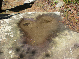 . Doug and Dan were fun guys, full of information. The point where we were talking was at a large rock (see photo) and Dan told me he called it Love Rock because the impression on it looked like a tractor seat and he could just imagine the woman who sat on it to make that mold. Ha! Gotta love that…Doug and Chris were deep in conversation about the many homesites and cemeteries in this part of the Park (Greenbrier) and Doug showed me his laminated copy of a hand-drawn map created by Lucinda Ogle (that name again!) that he obtained from the Park’s archives, drawn totally from her memory and not to scale, but not too far off scale, either. He gave us a rapid, detailed description of a homesite to look for on our way further down (went mostly over my head) and we parted company.
Chris and I talked about how to spot homesite conditions, flat sections that might have been old roads and fields, rock piles and so on. We began to recognize some of the things Doug had told us to look for, and suddenly we were off-trail , found a road bed, an old chimney, then a rock wall down to a creek bed, and one side of the creek bed was totally lined with stones. Wow! Then we picked up a faint manway to see where it went (we knew we were close to the end anyway) and followed it to the John Messer homestead.
When we returned to the Porters Creek Trail, the gates had been opened and a steady stream of people was walking to see the wildflowers – old, young, big, small, toddlers, sweethearts, everyone was out in the beautiful day. We saw one guy with a huge backpack and his girl carrying absolutely nothing – i.e., it’s the only way she would agree to go camping with him. And, yes, the parking lot was overflowing and cars parked all up and down the gravel road. Spring is here! What an outstanding day!
I left Chris and drove back to Gatlinburg for my last hike of this trip – Gatlinburg Trail. I parked at the Happy Hiker Outfitters, asked permission to leave my car (they said yes) and then walked the Gatlinburg Trail to the Sugar lands VC. The first half is a nice little greenway, the second half is a bit dull as it passes Park maintenance buildings, but it follows the West Prong of the Little Pigeon River which looks mighty powerful. In some places you can step off the path and s
 oak your tootsies. The most interesting sights along the path are an intact old chimney, a unusual set of round steps from a homesite building , and a cemetery right by the Visitor Center. Of course, I paused there and took a couple of photos. Then I retraced my steps back to my car at the Happy Hiker.
I could not resist driving Newfound Gap Road through the Park. There were lots of cars out and many people stopped at every overlook. The air was warm, the sky was a deep blue and there was the slightest hint of spring green in the lower elevations. We didn’t know then that two days later it would be snowing!
One more trail to hike and then this adventure will be done. Now, about that old hand-drawn map and those old manways...
"The trails of the world be countless,
And most of the trails be tried;
You tread on the heels of the many,
Till you come where the ways divide;
And one lies safe in the sunlight,
And the other is dreary and wan,
Yet you look aslant at the Lone Trail,
And the Lone Trail lures you on."
~Robert Service, The Lone Trail
Today was my last big climb of the Smokies 900 and I was looking forward to seeing my hiking buddy, Chris Hibbard of YourSmokies.com. Chris spends more time in the Park than anyone except the critters and he can teach the interested listener all day long. Chris has hiked every trail in the Park multiple times and was being kind enough to accompany me up Brushy Mountain. We met at 8:00 a.m. at the Porters Creek trailhead – can you believe we were the first people there? We knew when we came out that the place would be packed, since it was a beautiful wildflower Saturday.
We moved quickly up Porters Creek to the Brushy Mountain Trail and bypassed the John Messer place, planning to stop on our return route. Brushy
 Mountain is a steady uphill climb, an absolutely beautiful trail, and as it climbs up the slopes of Mt. LeConte its switchbacks leave you wondering why you are walking away from Brushy Mountain. There are a couple of crossings of Trillium Branch, one featuring this unexpected (for me) and enchanting cascade. We took note of an incredibly large and seemingly healthy hemlock beside the trail – we couldn’t find any evidence that it was being treated for hemlock woolly adelgid
  and Chris made a note of it to ask the Park service. The wildflowers were faring better in today’s sunshine and the trout lilies were outstanding. We walked through moss-covered boulder fields
 and dying stands of hemlock. The trees in this photo seemed to grow right out of the rocks towering 50 feet above the trail. At last we reached the intersection with Trillium Gap Trail and turned right to head for Brushy Mountain’s summit. All the way up we exclaimed at the picture-perfect day – as Chris said, a “10 out of 10”.
The trail here is deeply carved in the mountain laurel and it reminded me of the spur trail to the Jum
 poff. At the top the trail wanders around to viewpoints in three directions, west toward Pigeon Forge, north towards the Greenbrier Pinnacle section, and south towards the peaks of Mt. LeConte (over my should
 er here). One little mountain was particular interesting as it insinuated itself directly in the view of Pigeon Forge – it was obviously outside the Park boundary and neither of us knew what it was. Chris pointed out his mountain where he lived in Sevierville and the encroaching development on nearby summits. We had the place to ourselves for all of seven minutes before a couple of groups emerged from the mountain laurel tunnel.
We sat down to eat facing the Jumpoff and Charlies Bunion and stayed longer than I’ve sat down anywhere these past winter months. In preparation to leave, Chris walked over to the Pigeon Forge view to try to get a cell signal to update his Twitter fans (gotta love that technology!) There was a multi-generational group having lunch there, and soon the elderly gentleman of the group came over to start a conversation – reminded me of my dad, who could talk to anybody about absolutely anything. “Hi, have you been up here before?” and so on. I did not ask his age, but I’d put him in his late 70’s. Chris, a skilled interviewer, asked if he was from around here – yes – was his family from around here – yes – and then the $64,000 question: What is your family name? Ogle.
Now, that name is woven all through these mountains and opened a broad conversation about his family members that lived in the Park and shared some great stories. Then he turned around and pointed to the little mountain in front of Pigeon Forge and told us that his daddy was born and raised right at the base of that mountain, used to be called Roundtop. We thanked him for his time, wished him a great day, and as we turned to retrace our steps Chris commented, “What are the chances that we would be up here today, that we would wonder about that mountain, and then we would meet an Ogle up here that knows the answer?” Nothing is by chance.
Time was getting away from us and we picked up the pace going back down the mountain. More than halfway down we met two guys, one of whom Chris knew and had done some off-trail exploring with, and we stopped to talk
 . Doug and Dan were fun guys, full of information. The point where we were talking was at a large rock (see photo) and Dan told me he called it Love Rock because the impression on it looked like a tractor seat and he could just imagine the woman who sat on it to make that mold. Ha! Gotta love that…Doug and Chris were deep in conversation about the many homesites and cemeteries in this part of the Park (Greenbrier) and Doug showed me his laminated copy of a hand-drawn map created by Lucinda Ogle (that name again!) that he obtained from the Park’s archives, drawn totally from her memory and not to scale, but not too far off scale, either. He gave us a rapid, detailed description of a homesite to look for on our way further down (went mostly over my head) and we parted company.
Chris and I talked about how to spot homesite conditions, flat sections that might have been old roads and fields, rock piles and so on. We began to recognize some of the things Doug had
 told us to look for, and suddenly we were off-trail , found a road bed, an old chimney, then a rock wall down to a creek bed, and one side of the creek bed was totally lined with stones. Wow! Then we picked up a faint manway to see where it went (we knew we were close to the end anyway) and followed it to the John Messer homestead.
When we returned to the Porters Creek Trail, the gates had been opened and a steady stream of people was walking to see the wildflowers – old, young, big, small, toddlers, sweethearts, everyone was out in the beautiful day. We saw one guy with a huge backpack and his girl carrying absolutely nothing – i.e., it’s the only way she would agree to go camping with him. And, yes, the parking lot was overflowing and cars parked all up and down the gravel road. Spring is here! What an outstanding day!
I left Chris and drove back to Gatlinburg for my last hike of this trip – Gatlinburg Trail. I parked at the Happy Hiker Outfitters, asked permission to leave my car (they said yes) and then walked the Gatlinburg Trail to the Sugar
 lands VC. The first half is a nice little greenway, the second half is a bit dull as it passes Park maintenance buildings, but it follows the West Prong of the Little Pigeon River which looks mighty powerful. In some places you can step off the path and s
 oak your tootsies. The most interesting sights along the path are an intact old chimney, a unusual set of round steps from a homesite building , and a cemetery right by the Visitor Center. Of course, I paused there and took a couple of photos. Then I retraced my steps back to my car at the Happy Hiker.
I could not resist driving Newfound Gap Road through the Park. There were lots of cars out and many people stopped at every overlook. The air was warm, the sky was a deep blue and there was the slightest hint of spring green in the lower elevations. We didn’t know then that two days later it would be snowing!
One more trail to hike and then this adventure will be done. Now, about that old hand-drawn map and those old manways...
"The trails of the world be countless,
And most of the trails be tried;
You tread on the heels of the many,
Till you come where the ways divide;
And one lies safe in the sunlight,
And the other is dreary and wan,
Yet you look aslant at the Lone Trail,
And the Lone Trail lures you on."
~Robert Service, The Lone Trail
Wednesday, April 8, 2009
If A Hiker Falls In The Woods And Nobody Sees Her...
4/3/09 – Anthony Creek Trail/Russell Field Trail out-and-back and Twin Creeks Trail – 14 miles
Today the rain caught up with me – glad I didn’t have to see how much wetter Wet Bottom can get! I was the only soul in the Cades Cove picnic parking area for my hike up Russell Field Trail to the Appalachian Trail. Relax, this is going to be a short post because the weather did not improve.
My first 1.7 miles was on Anthony Creek Trail, nothing too exciting except the water was gushing nicely. I had only walked a half-mile when two backpackers passed me coming down. I thought I recognized the younger one, and as I turned around to double check, so did he. Turns out it was the two trail maintainers that Lenny and I had met repairing bear cables at a Deep Creek campsite a couple of weeks ago! And I was mistaken – the younger fella is a volunteer but the older fella is a Park Service employee. They had spent the night at Russell Field Shelter waiting on a problem bear, but the bear didn’t show up. Hey…I’m hiking up to that shelter now…
At the junction I turned right onto Russell Field Trail and began a steady climb. A couple of crossings of the Left Prong of Anthony Creek were interesting. I can proclaim that Russell Field is the muddiest trail I have hiked in the Park. Horses had been on it recently to churn things up and then the rain came pouring down. Fort unately, I had learned my lesson about wearing gaiters on the last AT backpack weekend so I had strapped them on this morning. They were totally smeared by the end of the hike and so protected my boot tops and pants legs well. All my attention was needed to watch my footing so I didn’t take many photos – but this fallen log was quite interesting.
Up, up, up Russell Field, to the gap where it reaches the ridge line and levels out. The wind was rather fierce here and I hurried along to get some protection where the trail slightly drops below the ridge. The clouds were so thick that visibility was about 20 paces ahead. Russell Field itself is a bald, today part grass and part forest, but once used for grazing cattle. This is what I saw:
So no need to linger, as the trail goes on up to intersect the Appalachian Trail at Russell Field Shelter. This shelter is still the old style with a chain link fence across the front and no extended roof and built-in benches and tabletops for cooking and lounging – although any port in a storm will do. No one else there, not even the problem bear, and I ate a lonely and soggy lunch while reading the shelter journal - lots of thru-hikers coming along now, leaving messages for each other. The last message written was by kygraybeard, who is actually a ridge runner for this section of the AT in the Smokies, reporting that a mama bear and her two cubs are back from last year looking for food at the shelter. I ate faster and then started back down the mountain.
One advantage of hiking solo is that no one sees you fall. I slipped on a water bar and gave it a good effort before landing splat on my side in the mud. Carol would have been disappointed – I did not stop to take a picture of myself. Nothing hurt but my ego, but it was a good reminder that slippery downhill trails are the best way to get hurt out here. Soon after I passed the alleged Russell Field bald I met two older gentlemen hikers who are aspiring to the Smokies 900 too – well, who else would be out on this trail in this weather? One of their first questions was do I hike alone often and do I worry about getting injured while alone? They said I could feel free to fall now because they would not be far behind to rescue me. Nice guys! But seriously, I do enjoy meeting other hikers and chatting it up.
The hike down was slow because of the m ud, although still not much to see. In the last half-mile of Russell Field Trail the wildflowers were struggling to open, so I guess this is o
 rdinarily an enjoyable hike. By the time you read this the trout lillies will be spectacular, I’m sure. I saw some interesting unfurling ferns, which I love because they have that “Little Shop Of Horrors” look to them. Feed me!
I passed a group of backpackers heading out for a weekend jaunt as I neared the parking lot. Kudos to them for not letting the rain change their plans! I hope they had a great experience.
It was early afternoon and I had time for one of the two short trails that remained on my list and chose Twin Creeks, so I began the long drive to Gatlinburg. Not many cars along Laurel Creek and Little River Roads, so I did not endanger anyone as I gawked at the enormous trilliums (both white and yellow ones) growing on the slopes alongside the roads. Can you imagine being able to identify those beauties at th e blinding speed of 35 miles per hour on curving, winding roads? I’m telling ya, they was HUGE! And no place to pull over to take photos…which is why they are able to grow so well there…no one can pull over and disturb them.
I found the trailhead for Twin Creeks just past the GSMNP sign on Cherokee Orchard Road and squeezed my car into a pull-off. This trail would be great for families with kids, lots to see if you just start looking, rock walls and rock piles, gets close to the creek and then farther away, and now the trilliums are up close and personal and growing by the gazillions. I hiked the two miles to the intersecti on with the Bud Ogle Nature Trail and then back to my car. Hey…it’s stopped raining!
There was a pizza with my name on it waiting at Ogle’s Pizza & Pasta on Hwy 321 and my cozy little Smoky Pines hotel room. Gee, I’m gonna miss this part…
Sunshine is delicious, rain is refreshing, wind braces us up, snow is exhilerating; there is really no such thing as bad weather, only different kinds of good weather. ~Anonymous
Today the rain caught up with me – glad I didn’t have to see how much wetter Wet Bottom can get! I was the only soul in the Cades Cove picnic parking area for my hike up Russell Field Trail to the Appalachian Trail. Relax, this is going to be a short post because the weather did not improve.
My first 1.7 miles was on Anthony Creek Trail, nothing too exciting except the water was gushing nicely. I had only walked a half-mile when two backpackers passed me coming down. I thought I recognized the younger one, and as I turned around to double check, so did he. Turns out it was the two trail maintainers that Lenny and I had met repairing bear cables at a Deep Creek campsite a couple of weeks ago! And I was mistaken – the younger fella is a volunteer but the older fella is a Park Service employee. They had spent the night at Russell Field Shelter waiting on a problem bear, but the bear didn’t show up. Hey…I’m hiking up to that shelter now…
At the junction I turned right onto Russell Field Trail and began a steady climb. A couple of crossings of the Left Prong of Anthony Creek were interesting. I can proclaim that Russell Field is the muddiest trail I have hiked in the Park. Horses had been on it recently to churn things up and then the rain came pouring down. Fort
 unately, I had learned my lesson about wearing gaiters on the last AT backpack weekend so I had strapped them on this morning. They were totally smeared by the end of the hike and so protected my boot tops and pants legs well. All my attention was needed to watch my footing so I didn’t take many photos – but this fallen log was quite interesting.
Up, up, up Russell Field, to the gap where it reaches the ridge line and levels out. The wind was rather fierce here and I hurried along to get some protection where the trail slightly drops below the ridge. The clouds were
 so thick that visibility was about 20 paces ahead. Russell Field itself is a bald, today part grass and part forest, but once used for grazing cattle. This is what I saw:
So no need to linger, as the trail goes on up to intersect the Appalachian Trail at Russell Field Shelter. This shelter is still the old style with a chain link fence across the front and no extended roof and built-in benches and tabletops for cooking and lounging – although any port in a storm will do. No one else there, not even the problem bear, and I ate a lonely and soggy lunch while reading the shelter journal - lots of thru-hikers coming along now, leaving messages for each other. The last message written was by kygraybeard, who is actually a ridge runner for this section of the AT in the Smokies, reporting that a mama bear and her two cubs are back from last year looking for food at the shelter. I ate faster and then started back down the mountain.
One advantage of hiking solo is that no one sees you fall. I slipped on a water bar and gave it a good effort before landing splat on my side in the mud. Carol would have been disappointed – I did not stop to take a picture of myself. Nothing hurt but my ego, but it was a good reminder that slippery downhill trails are the best way to get hurt out here. Soon after I passed the alleged Russell Field bald I met two older gentlemen hikers who are aspiring to the Smokies 900 too – well, who else would be out on this trail in this weather? One of their first questions was do I hike alone often and do I worry about getting injured while alone? They said I could feel free to fall now because they would not be far behind to rescue me. Nice guys! But seriously, I do enjoy meeting other hikers and chatting it up.
The hike down was slow because of the m
 ud, although still not much to see. In the last half-mile of Russell Field Trail the wildflowers were struggling to open, so I guess this is o
 rdinarily an enjoyable hike. By the time you read this the trout lillies will be spectacular, I’m sure. I saw some interesting unfurling ferns, which I love because they have that “Little Shop Of Horrors” look to them. Feed me!
I passed a group of backpackers heading out for a weekend jaunt as I neared the parking lot. Kudos to them for not letting the rain change their plans! I hope they had a great experience.
It was early afternoon and I had time for one of the two short trails that remained on my list and chose Twin Creeks, so I began the long drive to Gatlinburg. Not many cars along Laurel Creek and Little River Roads, so I did not endanger anyone as I gawked at the enormous trilliums (both white and yellow ones) growing on the slopes alongside the roads. Can you imagine being able to identify those beauties at th
 e blinding speed of 35 miles per hour on curving, winding roads? I’m telling ya, they was HUGE! And no place to pull over to take photos…which is why they are able to grow so well there…no one can pull over and disturb them.
I found the trailhead for Twin Creeks just past the GSMNP sign on Cherokee Orchard Road and squeezed my car into a pull-off. This trail would be great for families with kids, lots to see if you just start looking, rock walls and rock piles, gets close to the creek and then farther away, and now the trilliums are up close and personal and growing by the gazillions. I hiked the two miles to the intersecti
 on with the Bud Ogle Nature Trail and then back to my car. Hey…it’s stopped raining!
There was a pizza with my name on it waiting at Ogle’s Pizza & Pasta on Hwy 321 and my cozy little Smoky Pines hotel room. Gee, I’m gonna miss this part…
Sunshine is delicious, rain is refreshing, wind braces us up, snow is exhilerating; there is really no such thing as bad weather, only different kinds of good weather. ~Anonymous
The Third Time Is the Charm
4/2/09 - Wet Bottom Trail (Again)
Driving around the Cades Cove loop on this Thursday afternoon was practically painless - not many cars and the drivers all understood the signage that says "pull over." A big wind was picking up, though, and I kept one eye on the sky as clouds moved over the mountains to the east. Since I have tried and failed to complete the Wet Bottom Trail two times, I decided to start from the end that I thought I could handle via Cooper Road Trail.
At the trailhead I quickly moved my gear from the weekend backpack to the daypack, noticing that my clothes were blowing sideways and I had a hard time shutting the car door. Hhhmmm...high winds and dead trees....guess I'll go hiking! Not very smart, I admit, but this Smokies 900 is a sickness. Remember, I was alone so no one knew whether I was really completing this trail or not...The wind was not so threatening once I got into the woods, so I kept going.
I found the spot where I went awry on the first attempt - the detour to the right to the Elijah Oliver Cabin. I kept straight and can now confirm that Wet Bottom is indeed wet. I followed the horse tracks and passed the fence that the Park service has erected to keep the wild hogs out of the Abrams Creek flood plain.
Ultimately I came to Abrams Creek itself and had to make a choice. I had hiked Wet Bottom Trail from the opposite end up to this point but did not cross the creek - I mistakenly turned right onto an animal trail and got myself lost. So I really didn't have to go any farther to consider this trail completed...except for crossing the creek itself. What would a Smokies 900 hiker do?
Twenty years from now you will be more disappointed by the things you didn't do, than by the ones you did do – Mark Twain
Driving around the Cades Cove loop on this Thursday afternoon was practically painless - not many cars and the drivers all understood the signage that says "pull over." A big wind was picking up, though, and I kept one eye on the sky as clouds moved over the mountains to the east. Since I have tried and failed to complete the Wet Bottom Trail two times, I decided to start from the end that I thought I could handle via Cooper Road Trail.
At the trailhead I quickly moved my gear from the weekend backpack to the daypack, noticing that my clothes were blowing sideways and I had a hard time shutting the car door. Hhhmmm...high winds and dead trees....guess I'll go hiking! Not very smart, I admit, but this Smokies 900 is a sickness. Remember, I was alone so no one knew whether I was really completing this trail or not...The wind was not so threatening once I got into the woods, so I kept going.

I found the spot where I went awry on the first attempt - the detour to the right to the Elijah Oliver Cabin. I kept straight and can now confirm that Wet Bottom is indeed wet. I followed the horse tracks and passed the fence that the Park service has erected to keep the wild hogs out of the Abrams Creek flood plain.
Ultimately I came to Abrams Creek itself and had to make a choice. I had hiked Wet Bottom Trail from the opposite end up to this point but did not cross the creek - I
mistakenly turned right onto an animal trail and got myself lost. So I really didn't have to go any farther to consider this trail completed...except for crossing the creek itself. What would a Smokies 900 hiker do? Twenty years from now you will be more disappointed by the things you didn't do, than by the ones you did do – Mark Twain
Tuesday, April 7, 2009
Beer and Chainsaws
Lakeshore Trail Overnight Backpack – 4/2/09 – Day Two – Campsite 76 to Trailhead at Tunnel – 12 Miles
My 15-degree sleeping bag was much too hot but I had a somewhat restful night. We woke up, had some hot tea but didn’t feel very hungry, so we packed up and were on our way shortly after 8:00 a.m. The packs seemed heavier today, possibly because we were thinking about all the stuff we were carrying that we did not use, but “better to have it and not need it than to need it and not have it”…But the weather was warm and the lake was still there and we are the Mighty 900 milers, so on we went.
The first point of interest we came to was after three miles, Campsite 98 – actually, we saw the spur trail to the real campsite, but there is an illegal campsite right on the trail where it skirts a finger of the lake. As we sat for a bite to eat (we were finally hungry) we looked across the small stream and noticed a pile of stuff. We figured that someone had brought their cam ping gear up by boat and dumped it and were coming back later and we went to check it out. Pictured is what we found: trash and lots of it. This is not trash from one visit, but a dump site that continues to grow. There are parts of boats and Styrofoam coolers, old shoes, liquor bottles, even an old ripped up tent. Most puzzling was the fact that people take the time to gather it in one place…so why don’t they put it on the dang boat and haul it away?
The Lakeshore’s character continued to be Sybil-like (changed a lot) and at times seemed to slide off the mountain. We met another lone backpacker today doing a multi-day trip, this one on the AT from Fontana to Clingmans, then down Forney Ridge/Forney Creek, and now heading on Lakeshore back to Fontana. After talking with him and the fellow from yesterday, I realized that I have followed my own hike plans very narrowly and there are countless ways to form loops and multi-day trips. All good things to remember for the next time around, right?
We passed two more spur trails for cemeteries today but we did not investigate them. The spirit was willing but the flesh was weak – feet were beginning to get sore, some blisters were forming, and those packs continued to bear down. I have concluded that 12-mile backpack days are too much starting out and if (when) I do the Lakeshore again I will break up the days more and truly devote myself to exploring the artifacts. We found several homesites close to the trail, more chimneys and rock walls and rusting buckets. One large site featured terrace walls made of stacked stone where the owners farmed their land on the hillside. Apples were a staple crop and we saw a few apple trees blossoming along the way.
After seven miles the mostly level trail began its ups and downs that would continue to the end. We continually stepped over blowdowns, too many to count. And then we heard a funny noise…is that a chainsaw? Are they allowe d in the park? The regulations are different for national parks and national forests – one of them only allows hand saws to do trail maintenance. But heck, we were thrilled to hear that whining sound because it meant no more blowdowns to haul our butts over! As we got closer we could hear guys talking, and I speculated that they were probably on horseback to be carrying such heavy equipment. Sure enough, here come our heroes! There were 5 guys and 6 horses. They had strapped a couple of milk crate type baskets across the work horse so he could carry the gear. We got as far off the narrow trail as we could to let the horses pass. Everyone said “hey” and the last guy in line was careful not to spill his beer. Yep, beer and chainsaws, my kind of party – after all, it was 10:30 a.m.! But the hiking was easier from that point on.
We paused at Campsite 74, a huge spot beside Forney Creek, and then pressed on to the trailhead. This was Judy’s first time in this part of the Park and I had told her about the dreaded Tunnel at the end. Because the Tunnel is straight and you can see one end from the
 other end, it looks benign. But it’s longer than it seems, right, Judy? I’m always glad to get out of the Tunnel. Here’s a little graffiti near the entrance by one of the local high school artists.
And thus the Lakeshore Trail was conquered.
We stopped at McDonald’s in Bryson City for the bathroom and French Fries and then drove back to Fontana Marina for my car. Then Judy headed home and I drove Highway 129 (the Tail of the Dragon) over to Townsend – I would be hiking out of Cades Cove the next day. As I looked at my watch, I made a deal with myself. If I could get there by 5:00 p.m., I would make another run at that pesky Wet Bottom Trail.
My 15-degree sleeping bag was much too hot but I had a somewhat restful night. We woke up, had some hot tea but didn’t feel very hungry, so we
 packed up and were on our way shortly after 8:00 a.m. The packs seemed heavier today, possibly because we were thinking about all the stuff we were carrying that we did not use, but “better to have it and not need it than to need it and not have it”…But the weather was warm and the lake was still there and we are the Mighty 900 milers, so on we went.
The first point of interest we came to was after three miles, Campsite 98 – actually, we saw the spur trail to the real campsite, but there is an illegal campsite right on the trail where it skirts a finger of the lake. As we sat for a bite to eat (we were finally hungry) we looked across the small stream and noticed a pile of stuff. We figured that someone had brought their cam
 ping gear up by boat and dumped it and were coming back later and we went to check it out. Pictured is what we found: trash and lots of it. This is not trash from one visit, but a dump site that continues to grow. There are parts of boats and Styrofoam coolers, old shoes, liquor bottles, even an old ripped up tent. Most puzzling was the fact that people take the time to gather it in one place…so why don’t they put it on the dang boat and haul it away?
The Lakeshore’s character continued to be Sybil-like (changed a lot) and at times seemed to slide off the mountain. We met another lone backpacker today doing a multi-day trip, this one on the AT from Fontana to Clingmans, then down Forney Ridge/Forney Creek, and now heading on Lakeshore back to Fontana. After talking with him and the fellow from yesterday, I realized that I have followed my own hike plans very narrowly and there are countless ways to form loops and multi-day trips. All good things to remember for the next time around, right?
We passed two more spur trails for cemeteries today but we did not investigate them. The spirit was willing but the flesh was weak – feet were beginning to get sore, some blisters were forming, and those packs continued to bear down. I
 have concluded that 12-mile backpack days are too much starting out and if (when) I do the Lakeshore again I will break up the days more and truly devote myself to exploring the artifacts. We found several homesites close to the trail, more chimneys and rock walls and rusting buckets. One large site featured terrace walls made of stacked stone where the owners farmed their land on the hillside. Apples were a staple crop and we saw a few apple trees blossoming along the way.
After seven miles the mostly level trail began its ups and downs that would continue to the end. We continually stepped over blowdowns, too many to count. And then we heard a funny noise…is that a chainsaw? Are they allowe
 d in the park? The regulations are different for national parks and national forests – one of them only allows hand saws to do trail maintenance. But heck, we were thrilled to hear that whining sound because it meant no more blowdowns to haul our butts over! As we got closer we could hear guys talking, and I speculated that they were probably on horseback to be carrying such heavy equipment. Sure enough, here come our heroes! There were 5 guys and 6 horses. They had strapped a couple of milk crate type baskets across the work horse so he could carry the gear. We got as far off the narrow trail as we could to let the horses pass. Everyone said “hey” and the last guy in line was careful not to spill his beer. Yep, beer and chainsaws, my kind of party – after all, it was 10:30 a.m.! But the hiking was easier from that point on.
We paused at Campsite 74, a huge spot beside Forney Creek, and then pressed on to the trailhead. This was Judy’s first time in this part
 of the Park and I had told her about the dreaded Tunnel at the end. Because the Tunnel is straight and you can see one end from the
 other end, it looks benign. But it’s longer than it seems, right, Judy? I’m always glad to get out of the Tunnel. Here’s a little graffiti near the entrance by one of the local high school artists.
And thus the Lakeshore Trail was conquered.
We stopped at McDonald’s in Bryson City for the bathroom and French Fries and then drove back to Fontana Marina for my car. Then Judy headed home and I drove Highway 129 (the Tail of the Dragon) over to Townsend – I would be hiking out of Cades Cove the next day. As I looked at my watch, I made a deal with myself. If I could get there by 5:00 p.m., I would make another run at that pesky Wet Bottom Trail.
Monday, April 6, 2009
Little House in the Big Woods
Lakeshore Trail Overnight Backpack – 4/1/09 – Day One – Lakeshore Trail/Ollie Cove Trail/Lakeshore Trail to Campsite 76 – 13.5 Miles
Finishing the Lakeshore Trail was the last overnight hike to plan and there were not a lot of options for timing. Because of other obligations for both me and Judy, April 1 & 2 was do-or-die. The weather forecast was rain and thunderstorms, but we were sucking it up and getting prepared. I called up Fontana Marina to arrange a boat shuttle to (gasp) Hazel Creek. Would we get to see the infamous Ollie Cove drop-off point? The Marina guys remem- bered us as “the girls who missed the shuttle that day” and offered us a free ride, which I was quick to accept. And great news – the lake level had risen again to where we could be dropped off at the original Hazel Creek point! For those of you who haven’t read the back story on this, click here before you go any further.
I left my house in Charlotte at 5:45 a.m. and drove in the rain all the way to Bryson City, where I met Judy. We put a car at the Tunnel on Lake View Drive and headed over to Fontana Marina, still drizzling. We met up with Danny, our shuttle driver, and left the dock in a little pontoon boat at around 10:45 a.m. Along the way to Hazel Creek he spotted two wild boar on a hillside and took us up close to see them. He said he sees them along the shore quite often.

The lake was very still and the reflections in the water created awesome optical illusions. The bare shoreline seems to jut out like an overhanging cliff.
We rode around the last curve and there it was – Hazel Creek. When we were here (was it just a month ago?) the stone pylons of the w ashed-out bridge were at least ten feet tall and now they were visible barely a foot above the water. The bridge itself is lying up on the side of the mountain. (Click on photo to see full screen.) Danny said that the Park Service removed the beams that went across because they didn’t want people walking across them and getting hurt. When I was here back in April ’08 for my very first hike the bridge was still intact – and totally underwater. I didn’t even know it was there. Today there was a feeling of closure and triumph in coming back and conquering this place.
The rain had stopped when we got off the shuttle and – well, what it this? Shadows equal sunshine! Suddenly there were blue skies and white puffy clouds – April Fool’s! Today would have been my dad’s birthday, so I chose to see this as a gift from him. On his last birthday a year ago I spent the day with him and his sister, Rose, her husband, Clyde, and their daughter, Kim. We went to an all-you-can-eat buffet and had a grand time. He and Rose were both having health problems, but they laughed and joked and said things like, “We’re doing better than most folks, aren’t we?” The last photos taken of my dad were at lunch that day.
From the shuttle point we walked past Campsite 86 and to the Hazel Creek/Lakeshore Trail junction, waving at the Calhoun House where we had spent our dry night. (Here’s th e new trail sign that includes Ollie Cove in case you ever need to know where that alternate shuttle point is). Then we walked down the Ollie Cove Trail, just in case it gets included on the next Park t
 rail map. Soon we changed to short sleeves and zipped off pants legs as the temperature climbed – the one time we checked it was 77. Finally we got out the sunscreen. As we walked along the view of the lake stayed with us.
“Hiking Trails of the Smokies” or the “brown book” is invaluable for its trail descriptions and the Lakeshore Trail is an important one to read about. My only critique is that the description is written in sections and does not follow the trail in a linear fashion (same with its description of the AT). The logic is that it is written as the average person would hike sections of it, and some sections are written from the direction of the Fontana end, some from the Tunnel end. But notwithstanding this limitation, it has great information on cemeteries and homesites along the trail and greatly enhances the hiking experience. Judy and I have learned to recognize potential homesites – flat areas with a creek nearby signal us to look for piles of stones or stacked stones, then low stacked walls and chimneys.
Today we took the spur trail to Fairview Cemetery, which contains a significant number of graves (more than 30?) I continue to be fascinated by them
 . Here, among others, we saw the marker for a Confederate soldier and for twin infant boys.
Not too much farther along Lakeshore we saw another side spur to a cemetery, but very near the main trail were two graves. From the marker inscriptions (which we believe were placed later by descendants) we guessed that they are a young unwed mother and her infant, and that she probably died in childbirth. The spur trail continued on, presumably to the Cook cemetery, but we did not go farther. Interesting that these two graves were not actually in the cemetery…
Lakeshore Trail changes character frequently, a mixture of old roads, well-developed trails and sometimes barely discernable paths. (The “brown book” is a bit dated; its description cautions that the trail is hard to follow, but in reality there are plenty of signs to keep you on the right track.) It is not uncommon to walk around large trees growing in the middle of the otherwise wide road bed, which is evidence to me that Mother Nature will take care of herself just fine when we humans are not around to disrupt her.
We were actually surprised to meet one backpacker today who was doing a huge loop beginning at Big Creek, following the Benton MacKaye Trail to the AT at Fontana Dam, then planning to hike the AT back to Big Creek. But if you are looking for solitude, consider the Lakeshore Trail. It is underused because of its relative inaccessibility. All of the campsites are first come, first served, but I’ll bet they have never been full. (You should still register your plans at the Marina, though.) The hiking is easy to moderate and there is so much to see.
We passed Campsites 81 and 77 and arrived at our home for the night, Campsite 76. I was a little surprised to find it sitting right on the trail rather than slightly away from the trail. It is a very small campsite. But hey, we were the only ones here, right? The weather was warm, we had a babbling brook right there, and it was time to ditch those big backpacks. (We were prepared for rain, remember? We had tarps and rope and extra clothing and tons of stuff we didn’t need…thank goodness…)
The first order of business was setting up sleeping and I got a tour of Judy’s new tent. Here’s the scoop: Judy is an extraordinary seamstress and makes couture clothing and alterations, but she has recently branched out into – backpacking tents! Yes, boys and girls, the woman can do anything! Backpackers love cottage industry gear, and Judy is going to score big with her tent. It is a double-wall, one-person tent, weighs about 1.5 pounds, and the poles that prop it up are your hiking poles. How cool is that? There is tons of room inside, two people can sit up and play cards, and you can even bring your pack inside. Her website is still under construction, but she is already selling her creation at festivals and will be at Trail Days in Damascus on May 15-17, 2009. Or you can email her at heartfire@heartfiregowns.com. Tell her that Smoky Scout sent you and she’ll say…thanks!
After the tent tour, I wandered back into the woods away from the trail for a bathroom break and discovered a stacked stone wall. Going a little further back, I saw a second stacked stone wall and further still, a stacked stone chimney. Remember, this is a small campsite because there is a creek on one side and then the mountain rises up on the other side. This was a very cozy little spot for a homesite. It is not mentioned in the “brown book” at all so I felt like we had really discovered a hidden gem.
We reclined on comfortable rocks a nd ate dinner and by 8:00 p.m. we were ready for some rest. The sun was nearly gone, and then that big old moon popped out and lit up the night so that there was really no need for headlamps outside. I lay there and imagined living in the little house like Laura Ingalls, hearing that creek every night (it seemed to get louder as the night wore on) and waking up there every morning in the little holler in the mountains.
I think that I cannot preserve my health and spirits, unless I spend four hours a day at least - and it is commonly more than that - sauntering through the woods and over the hills and fields, absolutely free from all worldly engagements. ~Henry David Thoreau
Finishing the Lakeshore Trail was the last overnight hike to plan and there were not a lot of options for timing. Because of other obligations for both me and Judy, April 1 & 2 was do-or-die. The weather forecast was rain and thunderstorms, but we were sucking it up and getting prepared. I called up Fontana Marina to arrange a boat shuttle to (gasp)
 Hazel Creek. Would we get to see the infamous Ollie Cove drop-off point? The Marina guys remem- bered us as “the girls who missed the shuttle that day” and offered us a free ride, which I was quick to accept. And great news – the lake level had risen again to where we could be dropped off at the original Hazel Creek point! For those of you who haven’t read the back story on this, click here before you go any further.
I left my house in Charlotte at 5:45 a.m. and drove in the rain all the way to Bryson City, where I met Judy. We put a car at the Tunnel on Lake View Drive and headed over to Fontana Marina, still drizzling. We met up with Danny, our shuttle driver, and left the dock in a little pontoon boat at around 10:45 a.m. Along the way to Hazel Creek he spotted two wild boar on a hillside and took us up close to see them. He said he sees them along the shore quite often.

The lake was very still and the reflections in the water created awesome optical illusions. The bare shoreline seems to jut out like an overhanging cliff.
We rode around the last curve and there it was – Hazel Creek. When we were here (was it just a month ago?) the stone pylons of the w
 ashed-out bridge were at least ten feet tall and now they were visible barely a foot above the water. The bridge itself is lying up on the side of the mountain. (Click on photo to see full screen.) Danny said that the Park Service removed the beams that went across because they didn’t want people walking across them and getting hurt. When I was here back in April ’08 for my very first hike the bridge was still intact – and totally underwater. I didn’t even know it was there. Today there was a feeling of closure and triumph in coming back and conquering this place.
The rain had stopped when we got off the shuttle and – well, what
 it this? Shadows equal sunshine! Suddenly there were blue skies and white puffy clouds – April Fool’s! Today would have been my dad’s birthday, so I chose to see this as a gift from him. On his last birthday a year ago I spent the day with him and his sister, Rose, her husband, Clyde, and their daughter, Kim. We went to an all-you-can-eat buffet and had a grand time. He and Rose were both having health problems, but they laughed and joked and said things like, “We’re doing better than most folks, aren’t we?” The last photos taken of my dad were at lunch that day.
From the shuttle point we walked past Campsite 86 and to the Hazel Creek/Lakeshore Trail junction, waving at the Calhoun House where we had spent our dry night. (Here’s th
 e new trail sign that includes Ollie Cove in case you ever need to know where that alternate shuttle point is). Then we walked down the Ollie Cove Trail, just in case it gets included on the next Park t
 rail map. Soon we changed to short sleeves and zipped off pants legs as the temperature climbed – the one time we checked it was 77. Finally we got out the sunscreen. As we walked along the view of the lake stayed with us.
“Hiking Trails of the Smokies” or the “brown book” is invaluable for its trail descriptions and the Lakeshore Trail is an important one to read about. My only critique is that the description is written in sections and does not follow the trail in a linear fashion (same with its description of the AT). The logic is that it is written as the average person would hike sections of it, and some sections are written from the direction of the Fontana end, some from the Tunnel end. But notwithstanding this limitation, it has great information on cemeteries and homesites along the trail and greatly enhances the hiking experience. Judy and I have learned to recognize potential homesites – flat areas with a creek nearby signal us to look for piles of stones or stacked stones, then low stacked walls and chimneys.
Today we took the spur trail to Fairview
 Cemetery, which contains a significant number of graves (more than 30?) I continue to be fascinated by them
 . Here, among others, we saw the marker for a Confederate soldier and for twin infant boys.
Not too much farther along Lakeshore we saw another side spur to a cemetery, but very near the main trail were two graves. From the marker inscriptions (which we believe were placed later by descendants) we guessed that
 they are a young unwed mother and her infant, and that she probably died in childbirth. The spur trail continued on, presumably to the Cook cemetery, but we did not go farther. Interesting that these two graves were not actually in the cemetery…
Lakeshore Trail changes character frequently, a mixture of old roads, well-developed trails and sometimes barely discernable paths. (The “brown book” is a bit dated; its description cautions that the trail is hard to follow, but in reality there are plenty of signs to keep you on the right track.) It is not uncommon to walk around large trees growing in the middle of the otherwise wide road bed, which is evidence to me that Mother Nature will take care of herself just fine when we humans are not around to disrupt her.
We were actually surprised to meet one backpacker today who was doing a huge loop beginning at Big Creek, following the Benton MacKaye Trail to the AT at Fontana Dam, then planning to hike the AT back to Big Creek. But if you are looking for solitude, consider the Lakeshore Trail. It is underused because of its relative inaccessibility. All of the campsites are first come, first served, but I’ll bet they have never been full. (You should still register your plans at the Marina, though.) The hiking is easy to moderate and there is so much to see.
We passed Campsites 81 and 77 and arrived at our home for the night, Campsite 76. I was a little surprised to find it sitting right on the trail rather than slightly away from the trail. It is a very small campsite. But hey, we were the only ones here, right? The weather was warm, we had a babbling brook right there, and it was time to ditch those big backpacks. (We were prepared for rain, remember? We had tarps and rope and extra clothing and tons of stuff we didn’t need…thank goodness…)
The first order of business was setting up sleeping and I got a tour of Judy’s new tent. Here’s the scoop: Judy is an extraordinary seamstress and makes couture clothing and alterations, but she has recently branched out into – backpacking tents! Yes, boys and girls, the woman can do
 anything! Backpackers love cottage industry gear, and Judy is going to score big with her tent. It is a double-wall, one-person tent, weighs about 1.5 pounds, and the poles that prop it up are your hiking poles. How cool is that? There is tons of room inside, two people can sit up and play cards, and you can even bring your pack inside. Her website is still under construction, but she is already selling her creation at festivals and will be at Trail Days in Damascus on May 15-17, 2009. Or you can email her at heartfire@heartfiregowns.com. Tell her that Smoky Scout sent you and she’ll say…thanks!
After the tent tour, I wandered back into the woods away from the trail for a bathroom break and discovered a stacked stone wall. Going a little further back, I saw a second stacked stone wall and further still, a stacked stone chimney. Remember, this is a small campsite because there is a creek on one side and then the mountain rises up on the other side. This was a very cozy little spot for a homesite. It is not mentioned in the “brown book” at all so I felt like we had really discovered a hidden gem.
We reclined on comfortable rocks a
 nd ate dinner and by 8:00 p.m. we were ready for some rest. The sun was nearly gone, and then that big old moon popped out and lit up the night so that there was really no need for headlamps outside. I lay there and imagined living in the little house like Laura Ingalls, hearing that creek every night (it seemed to get louder as the night wore on) and waking up there every morning in the little holler in the mountains.
 I think that I cannot preserve my health and spirits, unless I spend four hours a day at least - and it is commonly more than that - sauntering through the woods and over the hills and fields, absolutely free from all worldly engagements. ~Henry David Thoreau
Subscribe to:
Posts (Atom)