
Dolly Sods Wilderness Hike – 4/24/10 – Red Creek Trail/Little Stonecoal Trail/Dunkenbarger Trail/Big Stonecoal Trail/Red Creek Trail – 7.5 miles
A dreary morning made it hard to get excited at the prospect of a wet hike. Somehow it’s okay if rain begins once you are into a hike, but why is it so hard to start out in the rain? We procrastinated a little in hopes of the weather clearing. Fortunately, although gray was the color of the day our hike stayed dry.
The spectacular drive to the Dolly Sods area built up anticipation for our adventure. Laneville Road’s multiple hairpin turns are similar to the Tail of the Dragon in western North Carolina with the addition of farmsteads and some vacation-type houses.
We followed three cars that looked like they knew where they were headed; consequently we blew past the Red Creek Trail parking area (signs were not visible from the road) and the pavement gave way to rutted gravel. The road became rocky and quite steep, driving reduced to 20 MPH and less. We knew we had gone too far when we reached a parking area for South Prong Trail, so we turned around and headed all the way back down. Red Creek was actually where the pavement ended.
A little history: In 1943 and '44 , the Army used the area as a practice range and maneuver area for training troops for World War II in Europe. Live artillery and mortar shells shot into the area for practice still exist in Dolly Sods.
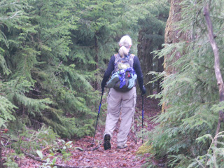
Our lollipop hike began on Red Creek Trail as a level half-mile walk to the first camping area, where wild confusion broke out. Being a wilderness area, camping is allowed anywhere and there is no signage. There were many worn pathways to campsites. We happened upon a group of two men and one middle school age boy who had just broken camp and were going the same direction. Together we found our way, marked only by a small rock cairn to indicate a faint path left which was Little Stonecoal (no sign, but about right mileage per GPS). This path led to our first crossing of Red Creek. Jim spent quite a bit of time trying to scout a rock-hop across while I waded on through, and he eventually followed.
 The water was… refreshing! As usual I had my Crocs because I hate wet hiking boots. The father of the boy crossed barefoot, dropped his backpack, then went back and piggy-backed the boy across. I asked him why he didn’t use his hiking poles and he wondered the same thing. Methinks the boy needs to learn to cross on his own.
A steep straight climb up Little Stonecoal Trail followed cascading Stonecoal Creek. Two waterfalls and a half dozen cascades were marked on my trail map, but all were barely visible even through winter trees, so in the summer it’s a scramble off-trail to check them out. We leapfrogged our new friends a couple of times and the trail was sketchy again as we approached the next junction, but we learned that the rock cairns begin appearing near intersections, sort of like painted double blazes that say “pay attention, a change is coming.” A bonus here: there was an actual wooden trail sign at the right turn.
The Dunken- barger Trail was very different, weaving through an alpine forest of Eastern hemlock and spruce, young trees, very thick, with no signs of disease like those in North Carolina. Mingled together were lar ge stands of rhododendron and mountain laurel. The footing was very muddy, could have fooled me for a horse trail. There was a Hansel & Gretel feeling all along this trail, closed in and limited sight distance. Campsites along the way were awesome, would be great fun to stay here.
At the next intersection we turned right onto Big Stonecoal Trail and stopped for lunch. We noticed several trees cut off about 1 to 2 feet above the ground with a rough axe chop. Looking around a little bit, we found a big campsite with a huge rock fire pit near a wide creek. I guess that’s where the woodchoppers burned their trees.
A dreary morning made it hard to get excited at the prospect of a wet hike. Somehow it’s okay if rain begins once you are into a hike, but why is it so hard to start out in the rain? We procrastinated a little in hopes of the weather clearing. Fortunately, although gray was the color of the day our hike stayed dry.
The spectacular drive to the Dolly Sods area built up anticipation for our adventure. Laneville Road’s multiple hairpin turns are similar to the Tail of the Dragon in western North Carolina with the addition of farmsteads and some vacation-type houses.
We followed three cars that looked like they knew where they were headed; consequently we blew past the Red Creek Trail parking area (signs were not visible from the road) and the pavement gave way to rutted gravel. The road became rocky and quite steep, driving reduced to 20 MPH and less. We knew we had gone too far when we reached a parking area for South Prong Trail, so we turned around and headed all the way back down. Red Creek was actually where the pavement ended.

A little history: In 1943 and '44 , the Army used the area as a practice range and maneuver area for training troops for World War II in Europe. Live artillery and mortar shells shot into the area for practice still exist in Dolly Sods.
Our lollipop hike began on Red Creek Trail as a level half-mile walk to the first camping area, where wild confusion broke out. Being a wilderness area, camping is allowed anywhere and there is no signage. There were many worn
 pathways to campsites. We happened upon a group of two men and one middle school age boy who had just broken camp and were going the same direction. Together we found our way, marked only by a small rock cairn to indicate a faint path left which was Little Stonecoal (no sign, but about right mileage per GPS). This path led to our first crossing of Red Creek. Jim spent quite a bit of time trying to scout a rock-hop across while I waded on through, and he eventually followed.
 The water was… refreshing! As usual I had my Crocs because I hate wet hiking boots. The father of the boy crossed barefoot, dropped his backpack, then went back and piggy-backed the boy across. I asked him why he didn’t use his hiking poles and he wondered the same thing. Methinks the boy needs to learn to cross on his own.
A steep straight climb up Little Stonecoal Trail followed cascading Stonecoal Creek. Two waterfalls and a half dozen cascades were
 marked on my trail map, but all were barely visible even through winter trees, so in the summer it’s a scramble off-trail to check them out. We leapfrogged our new friends a couple of times and the trail was sketchy again as we approached the next junction, but we learned that the rock cairns begin appearing near intersections, sort of like painted double blazes that say “pay attention, a change is coming.” A bonus here: there was an actual wooden trail sign at the right turn.
The Dunken- barger Trail was very different, weaving through an alpine forest of Eastern hemlock and spruce, young trees, very thick, with no signs of disease like those in North Carolina. Mingled together were lar
 ge stands of rhododendron and mountain laurel. The footing was very muddy, could have fooled me for a horse trail. There was a Hansel & Gretel feeling all along this trail, closed in and limited sight distance. Campsites along the way were awesome, would be great fun to stay here.
At the next intersection we turned right onto Big Stonecoal Trail and stopped for lunch. We noticed several trees cut off about 1 to 2 feet above the ground with a rough axe chop. Looking around a little bit, we found a big campsite with a huge rock fire pit near a wide creek. I guess that’s where the woodchoppers burned their trees.

Our descent down Big Stonecoal was an exercise in not rolling ankles, lots of rocks and steep elevation. There is no grading in Dolly Sods Wilderness. We passed through huge boulder fields. Can anyone identify the animal poop on this rock cairn?

Jim pointed out that I walked right by this carcass of a young deer – skull, rib cage, fur and lower legs and hooves intact.

At the bottom, another chill thrill crossing of Red Creek
Again head- scratching ensued at the myriad of paths to campsites. Another backpacking group came along (it is not lonely in Dolly Sods) and we checked bearings with them, but we still got off-trail and hit a couple of dead ends before finding the right trail and retracing our steps back to the parking area. Overall, we finished the 7.5 miles in 4.75 hours – not bad for navigating, stopping for breaks and lunch, etc. Although this was not the part of Dolly Sods that I’ve read the most about with balds and bare rock fields, this was a very interesting hike. I’d be happy to return for an overnight trip.

There was not enough time left to check out Seneca Rocks so we took a scenic drive on Highway 72, an even smaller road with even more twists and turns, incredibly picturesque with small farms and little white churches. We ended up in Parsons, which is nothing to write home about, and from there we drove towards Thomas/Davis, passing the wind turbines we had seen on our first day in the area. There also was not enough time to go back to our room in Canaan Valley to change clothes (I told you that nothing is close to anything), so we turned onto a side road and into a cemetery and changed in the car. Don’t laugh, it was very convenient!
Dinner at Muttley’s in Davis, WV – remember, eat local, tip big!
May you live all the days of your life. ~Jonathan Swift
2 comments:
Great trip report - that dead deer carcass is a little freaky though.
Pretty cool, though, huh? It couldn't have been there more than a day, looked fresh except no blood at all. Probably won't see anything like that again.
Post a Comment