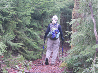
After the usual commute, today’s hike started from Bear Pen Gap. We retraced our steps on the blue blaze trail back to the MST (believe me, th
 at .6 mile counts). Here the MST is an old road bed with odd rows of massive rocks placed - to keep vehicles off? Then we scrambled up and down several huge earthen berms – to keep mountain bikers off? This would be an attractive trail for mountain bikers.
We checked out Charlie’s Bald and the camping area, where two tents were set up. The occupants were still snoozing until they heard us tramping around. Well, it was after 9:00 a.m. – come on, people, don’t sleep the day away!
 Flower of the day: painted trillium. We were very excited at the first sighting, and still not too jaded by the end of the day when we still foun
 d them in clusters along the trail. They are very striking blooms.
We crossed the BRP at about 2.5 miles – so far so good – and entered the Middle Prong Wilderness, so we didn’t expect any more white blazes. Immediately after crossing we stopped for a snack break and met two dayhikers out with a dog. The man said, “Even though I know my dog is friendly, you don’t, so he’s on a leash,” and I really appreciated his trail etiquette. So many other hikers have the attitude that their dog is “special” and exempt from leash regulations.
I was a bit astonished to meet a hunter in full camouflage with a shotgun. He was hunting turkey, but no luck today, and he didn’t slow down to chat. More than one person has asked me if I am afraid of dangerous people on the trail. While I didn’t consider this guy to be threatening, it made me think twice about hunters outside of deer and bear season (other seasons are longer). Should we be wearing blaze orange all the time in wilderness areas?
Interesting photos from the day:
The real thing this time - the dreaded garter snake
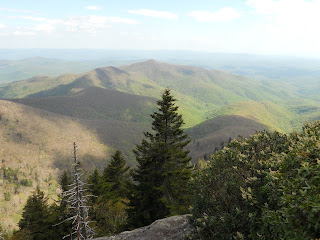
I was intent on summiting Mt. Hardy today as part of the SB6K challenge – after all, I was so close! I felt that Danny was not so keen on the mile side trip, and I told her she could take a long lunch break, but I guess after my episode  with the lost camera she was reluctant to “lose” me again. This hike is in her second book, Hiking North Carolina’s Blue Ridge Heritage, and she remember- ed it as a bushwhack (no maintained trail) so she brought some flagging tape. To our pleasant surprise, an easily discernible trail has been made and we only used the tape in a few places. The view from the top showcases Sam’s Knob and Little Sam (the “double top” mountain in the center).
Postscript: We didn’t actually reach the summit of Mt. Hardy after all. We stopped at a metal marker imbedded in a rock, enjoyed the view, and congratulated each other. I saw that the trail continued but I was under the impression that it simply went down the other side of the mountain. My good friend Jeff pointed out to me later that the true summit is a few hundred feet farther with a second metal marker. So…I will be going back to Mt. Hardy someday to bag the peak. Nothing to be disappointed about…just means I get to go hiking again!
Back at the bottom of the Mt. Hardy trail we paused for a well-deserved lunch rest. Just as we were packing up to leave, a man came jogging by wearing trail runners, no pack, no water. He introduced himself as Jim and explained that he was flagging the trail in preparation for the Smoky Mountain Relay Race that was coming through in a couple of days. I’m afraid we didn’t give him much chance to expound on his efforts before we began educating him on wilderness rules (no trail signs), etc. In retrospect I think we were a little hard on him and I’ll try to keep in mind that although we may know a little more than the average person on the trail, we don’t need to share our expertise in every two-minute trail encounter. Sometimes it’s okay to just smile and nod and say “Have a nice day.”
Back on the move: after we passed the Green Mountain Trail intersection I was in familiar territory from my backpack trip with Jeff, Laurie and Ken last summer (a shakedown in preparation for our Grand Tetons trip). Not much registered until we reached the spot where we had resupplied water, but then my memory kicked in as we passed our campsite, crossed Highway 215 and hiked on towards 816.
After we crossed 215 the trail character changed significantly – more blazes because we were out of the Middle Prong Wilderness, but the trail seemed stressed, very rocky, rooty, rutted, washed out. Here we also began a four-mile gradual uphill, at times steep. We passed a couple more open fields and one good look at the ominous Devil’s Courthouse.
I have become quite attached to Walt Weber’s detailed route drawings. Although once or twice there have been features that he does not note th at I feel should be included, overall the maps are excellent for details and figuring out where you are. He notes bridges, switch- backs, outstanding features like “big boulder” and “big funny tree.” But even when you know exactly where you are, the last mile is still always the longest.
 with the lost camera she was reluctant to “lose” me again. This hike is in her second book, Hiking North Carolina’s Blue Ridge Heritage, and she remember- ed it as a bushwhack (no maintained trail) so she brought some flagging tape. To our pleasant surprise, an easily discernible trail has been made and we only used the tape in a few places. The view from the top showcases Sam’s Knob and Little Sam (the “double top” mountain in the center).
Postscript: We didn’t actually reach the summit of Mt. Hardy after all. We stopped at a metal marker imbedded in a rock, enjoyed the view, and congratulated each other. I saw that the trail continued but I was under the impression that it simply went down the other side of the mountain. My good friend Jeff pointed out to me later that the true summit is a few hundred feet farther with a second metal marker. So…I will be going back to Mt. Hardy someday to bag the peak. Nothing to be disappointed about…just means I get to go hiking again!
Back at the bottom of the Mt. Hardy trail we paused for a well-deserved lunch rest. Just as we were packing up to leave, a man came jogging by wearing trail runners, no pack, no water. He introduced himself as Jim and explained that he was flagging the trail in preparation for the Smoky Mountain Relay Race that was coming through in a couple of days. I’m afraid we didn’t give him much chance to expound on his efforts before we began educating him on wilderness rules (no trail signs), etc. In retrospect I think we were a little hard on him and I’ll try to keep in mind that although we may know a little more than the average person on the trail, we don’t need to share our expertise in every two-minute trail encounter. Sometimes it’s okay to just smile and nod and say “Have a nice day.”
Back on the move: after we passed the Green Mountain Trail intersection I was in familiar territory from my backpack trip with Jeff, Laurie and Ken last summer (a shakedown in preparation for our Grand Tetons trip). Not much registered until we reached the spot where we had resupplied water, but then my memory kicked in as we passed our campsite, crossed Highway 215 and hiked on towards 816.

After we crossed 215 the trail character changed significantly – more blazes because we were out of the Middle Prong Wilderness, but the trail seemed stressed, very rocky, rooty, rutted, washed out. Here we also began a four-mile gradual uphill, at times steep. We passed a couple more open fields and one good look at the ominous Devil’s Courthouse.
I have become quite attached to Walt Weber’s detailed route drawings. Although once or twice there have been features that he does not note th
 at I feel should be included, overall the maps are excellent for details and figuring out where you are. He notes bridges, switch- backs, outstanding features like “big boulder” and “big funny tree.” But even when you know exactly where you are, the last mile is still always the longest.
One feature that is not specifically noted but is almost impossible to miss is a lookout po
 int to the right just as the MST intersects with the Art Loeb Trail to Shining Rock. After hours of rocks, roots, mountain laurel tunnels, slow uphills and knee- crunching downhills, just one minute in the presence of this grand view and all is forgiven and forgotten. I am so grateful to be able to hike in the mountains.
Read Danny’s version of the hike here.
I love to think of nature as an unlimited broadcasting station, through which God speaks to us every hour, if we will only tune in. ~George Washington Carver


