
Woke up this Saturday morning to the sounds of the Florida fellas packing up. My thermometer said 37 degrees – great temperature for inside a Smokies shelter in February. (The one good thing about rain is that it means warmer temperatures.) Judy and I ate and packed up while listening to the rain coming down. If we were thru-hikers, she said, we would wait a while to see if the rain slowed down, but we had a date with a boat shuttle at 3:30 p.m. down at Hazel Creek so we had to get going.
Amazingly, as we left the shelter the rain sto pped. The wind was brisk and the clouds were still thick, but at least we weren’t get soaked right away. On top of Spence Field we stopped to remove fleece jackets (we never learn, we always start out wearing them and then take them off after 15 minutes when we heat up) and admire the view. The mountains are stunning in any weather.
 pped. The wind was brisk and the clouds were still thick, but at least we weren’t get soaked right away. On top of Spence Field we stopped to remove fleece jackets (we never learn, we always start out wearing them and then take them off after 15 minutes when we heat up) and admire the view. The mountains are stunning in any weather.
 We turned right onto Jenkins Ridge Trail and an ominous soundtrack of organ music began playing in my head. This trail is infamous for its difficulty, and I can attest that its reputation is well-deserved. The brown book, "Hiking Trails of the Smokies," gives a great description. It is probably the roughest trail I have experienced in the Park. It starts out rocky and quite overgrown; we whipped through shoots of blackberry and other thorny stuff sometimes taller than we were and had to be careful not to get our eyes poked. There were numerous blowdowns, none too difficult, but frequent enough to be annoying rather than amusing. But still...it wasn't raining and we were walking gently downhill and going to be sleeping in a hotel tonight...Ahhh...Since Jenkins Ridge is sucha long trail without intersections, I brought copies of the "brown book" pages and followed our progress so we'd have an idea of where in the world we were. A steep ascent to Haw Gap got our attention, then a steep descent without switchbacks, then another ridiculously steep ascent up Cherry Knob, then another killer descent, then a steep ascent up to Woodward Knob... well, you get the picture. The "brown book" sums it up: “Depending upon whether one is going up or down, this stretch is a lung buster or a knee breaker.” Nice, huh? Tell me again why I’m doing this…
At Pickens Gap the trail abruptly leveled to a graded roadway (built by the CCC in the 1930s) that carried us two more miles down to the junction with Hazel Creek Trail. The
 one photo I took on our Jenkins Ridge journey was along this portion – this is an old engine laying in an open area beside the trail. Pickens Gap is noteworthy both as the site of the Adams-Westfeldt copper mine and as a dwelling of Horace Kephart in the early 1900s (he lived in a former caretaker’s cabin at the closed copper mine). During the past week I have been reading Kephart’s most famous book, Our Southern Highlanders, so I was very excited to be at this spot.
 Farther along Jenkins Ridge we passed a cemetery that I later kicked myself for not stopping at when I realized that it was the Higdon cemetery. Will I ever be there again?
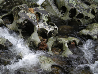 At the Hazel Creek junction we turned right and began the long walk to the Lakeshore Trail, enjoying boisterous Hazel Creek flowing alongside us the whole way. Isn’t this a cool photo of the holes in the rocks and the rocks in the holes?
We walked through the now-nonexistent towns of North Proctor and Proctor and got a glimpse of the kiln house and the Calhoun House and barn, rare buildings that were not torn down by the Park. All in all, an extremely interesting section of the Park.
Crossing the Proctor Bridge at Lakeshore Trail, we noted a brand new trail sign that included Ollie Cove Trail – interesting, I’ve never heard of this trail before and it’s not on any of my maps. Have to check that out when I get back home.
We continued down the spur trail past Campsite 86 – saw a tent set up there, another crazy person out in this weather - and down to the lake where our boat shuttle was to pick us up. We were 45 minutes early and feeling good to be ending our 14 miles with backpacks on.
But coming around the bend, something wasn’t right. When I caught the shuttle here back in April, the lake came up to the bank – now there was no lake in sight. There was Hazel Creek flowing like crazy around the next bend…and pylons that once supported a bridge…and a long wooden bridge slammed up against the mountainside. (Sorry, not thinking about photos right about now.) Not a good feeling. Several expletives came to mind.
There were footprints and we followed them down to the creek’s edge (actually, creek is not an accurate word at this point – raging river works better). There were multiple prints and clearly people had forded the creek here, so the boat shuttle pickup must be on the far side of the creek and around the bend where we couldn’t see. We couldn’t continue walking along the edge on our side because the bank became quite steep.
Well, we’ve crossed a lot of creeks, so we could do this. We scouted around, chose a path, unbuckled our packs and plunged in. Almost immediately the water was up to our butts, and Judy slipped and fell in, and we watched her hiking poles get swept away. Time to get back to the bank and rethink this!
Now Judy was soaked from head to toe and the bottom half of me was wet. The water was too deep and swift and crossing was not safe, so we needed to formulate a new plan. We decided to walk back and talk to the campers we had seen at Campsite 86, and I began to have a meltdown as the gravity of the situation sunk in.
We learned that the campers (a man and two teenage boys) had come over on their own boat and the footprints we saw on the creek bank belonged to them. They admitted that the water was swift and they’d had a rough time crossing. We knew we were not going to try again and that the only way out was to hike out via Lakeshore Trail to Fontana Dam – 10.4 miles. We had already hiked 14 miles today and it was now late afternoon. Judy had a tarp tent (now wet) but I had no tent at all.
But for all this bad luck, there was very good luck for us – the Calhoun House. We could see it from the campsite and decided to check it out. If we couldn’t get inside, we could at least sleep in the old barn, which Judy reminded me was just like sleeping in the shelter. And God is indeed good, because the house was wide open, with intact windows, no leaks, plenty of room and even a sofa on the front porch. We moved in, unpacked, hung clothes to dry, found enough dry clothes to put on, cooked dinner, made hot tea and then sat on the front porch and watched the creek flow by.
Judy was absolutely wonderful to me as I continued to struggle with tears and frustration over the circumstances. Her extensive backpacking experience had taught her much about flexibility and she decided that this was a wonderful adventure. I had to admit that although we were not where I wanted to be, we were dry, fed and safe. We were experienced hikers, we were prepared and we were smart. We sat on that porch and played the alphabet game: “I’m going to Hawaii and I’m going to take an Abacus…I’m going to Hawaii and I’m going to take an Abacus and a Bathing suit…” and I eventually calmed down.

The Calhoun House - B&B for us!

Front porch with Hazel Creek flowing by

Judy making tea and the best of it

Hanging clothes to dry - again
 First class
  Boiling water for some grits for supper
Hanging out on the front porch - I look like a caterpillar
We finally went to “bed” at 7:00 p.m. and began our long night together. We could hear critters scurrying around in the attic (squirrels?) and even in the other rooms of the house (squirrels again?) and Judy turned on her headlamp as a nightlight that we kept on all night. I know I dozed from time to time, dreaming, and then would wake up to thumps in the attic. We talked on and off during the night, planning an early departure at first light for our 10-mile hike to Fontana Dam and wondering if anyone was wondering where we were.
5 comments:
Now that's what I call making the best of it! A nice creekfront resort hotel complete with "nature sounds". :o) Great story that you and Judy won't soon forget.
I have to admit that what scares me most about this kind of situation is having others worry about why I'm not home. I feel well-prepared, as you were, but it's often not possible to contact others to let them know you're okay. Pat yourselves on the back for a successful self-rescue!
Great story. Glad you found a place to stay. It's kind of crazy that such a nice home like that isn't being used in some way by the park. That porch looks like it would be a great place to sip on some lemonade, or maybe a beer!
Wow SmokyScout, that is some story. I have a feeling that it will be one of those that looks a whole lot better in the rear-view mirror. In a couple of years, it will look like more of an adventure than it felt like in real-time.
Thanks for all your stories...I have really enjoyed following your progress. Makes me itch for a Smokies hike or two...which fortunately I get to do next month. I'm really looking forward to it and hoping for good weather.
Smokies trips two years in a row for me...yeah!
-- Juggler
Smoky, I met Judy this year on a hike to WhiteOak Sinks. She was very nice and talented, seamstress right? You wouldnt want to sit on the couch again if you saw what I saw! Its in the blog about the mice infestation :) enjoyed and now im more informed about jenkins ridge!
Post a Comment