
Benton MacKaye Trail in NC – Heart of Darkness: Beaverdam Bald/Sledrunner
Gap to Waucheesi Bald – 6/22/18 – 10+ Miles

Say the words “I’m thinking about hiking on the Benton
MacKaye Trail” and you’ll hear: “What’s that?” more frequently than “I’ve
always wanted to do that!” Less well known than its sexy older sibling, the
Appalachian Trail, nevertheless the BMT deserves attention and respect.
It’s a 300-mile trail through the Southern Appalachians,
named for the man who co-founded the Wilderness Society and envisioned a
footpath from Georgia to Maine now known as the Appalachian Trail. MacKaye originally
favored following the western crest of the Blue Ridge, but the AT ultimately
was located to the east of this area. The Benton MacKaye Trail, built between 1980 and 2005,
roughly follows MacKaye’s proposed route, lightly traveled and seriously rugged. The BMT
and the AT intersect in several places, near its southern terminus at Springer
Mountain and again at its northern terminus at Big Creek in Great Smoky
Mountains National Park, forming a grand loop for those inclined to sample
both. Check out the Benton MacKaye Trail Association.
The BMT blaze is a white diamond shape, a rarer sight than
the AT white rectangle blaze. The BMT passes through wilderness areas where
blazes are not used, and on occasion it coincides with old sections of the AT
and old rectangle blazes can be confusing. The section that challenged us for
four days closely follows the TN-NC state line atop the ridgeline. From our
first steps on our first day on the BMT, we realized that this wasn’t going to
be just a walk in the woods.
I proposed a plan to my hiking friend Mike of four days in
June on the Benton MacKaye Trail, knowing that he would critique, second guess,
tweak and ultimately improve upon my plan. Sure enough, he didn’t like my idea
to start at the beginning in Georgia. He
made a case for hiking at higher elevations to beat the heat, then sweetened
the deal by offering to provide shuttling for dayhiking rather than
backpacking. My friend Carol signed on too. Rather than basing in a campground,
Mike rented the Donley Cabin in Cherokee National Forest ($35/night, National
Forest Service). Check out the history of the cabin here and the rental information here.
Carol and I left Charlotte at 6:00 a.m. on Friday morning to
meet Mike at Stratton Ridge Overlook on Cherahala Skyway, west of
Robbinsville, NC. After five hours of serious driving, we arrived by 11:00 a.m.,
Mike soon after.
We settled at a picnic table for lunch and Mike gave us his suggestions. He’d been in the area since the day before, driving all the forest
roads, checking out trail access points, if gates were open, road conditions,
parking. That kind of advance work is invaluable and Mike enjoys the logistical
problem solving and matching what’s on the ground with what’s on a map. You’ve
got to be flexible when he’s on your team or be steadfast when he lobbies for
changes but you like it the way it is. Oftentimes he’s right (just don’t tell
him I said that). Part of the scoop was his observation that it rains every
afternoon, sometimes violent thunderstorms, so we should take that into account
for distances and timing.
First stop: Donley Cabin during daylight to get our
bearings. Since we weren’t backpacking, we’d packed heavy with coolers and real
food, extra clothes (thank goodness, we would need them) and I even brought my
pillow.
In a warren of forest roads, we parked at a pull-off beside
the North River and sorted gear to walk a quarter-mile to the cabin. [This is when Mike told us he’d be sleeping
in his converted van.] Three water crossings, the first on a sturdy bridge, the
second on a primitive log with a cable strung as a railing, a third small seep,
and a bit of uphill took us back more than a century.


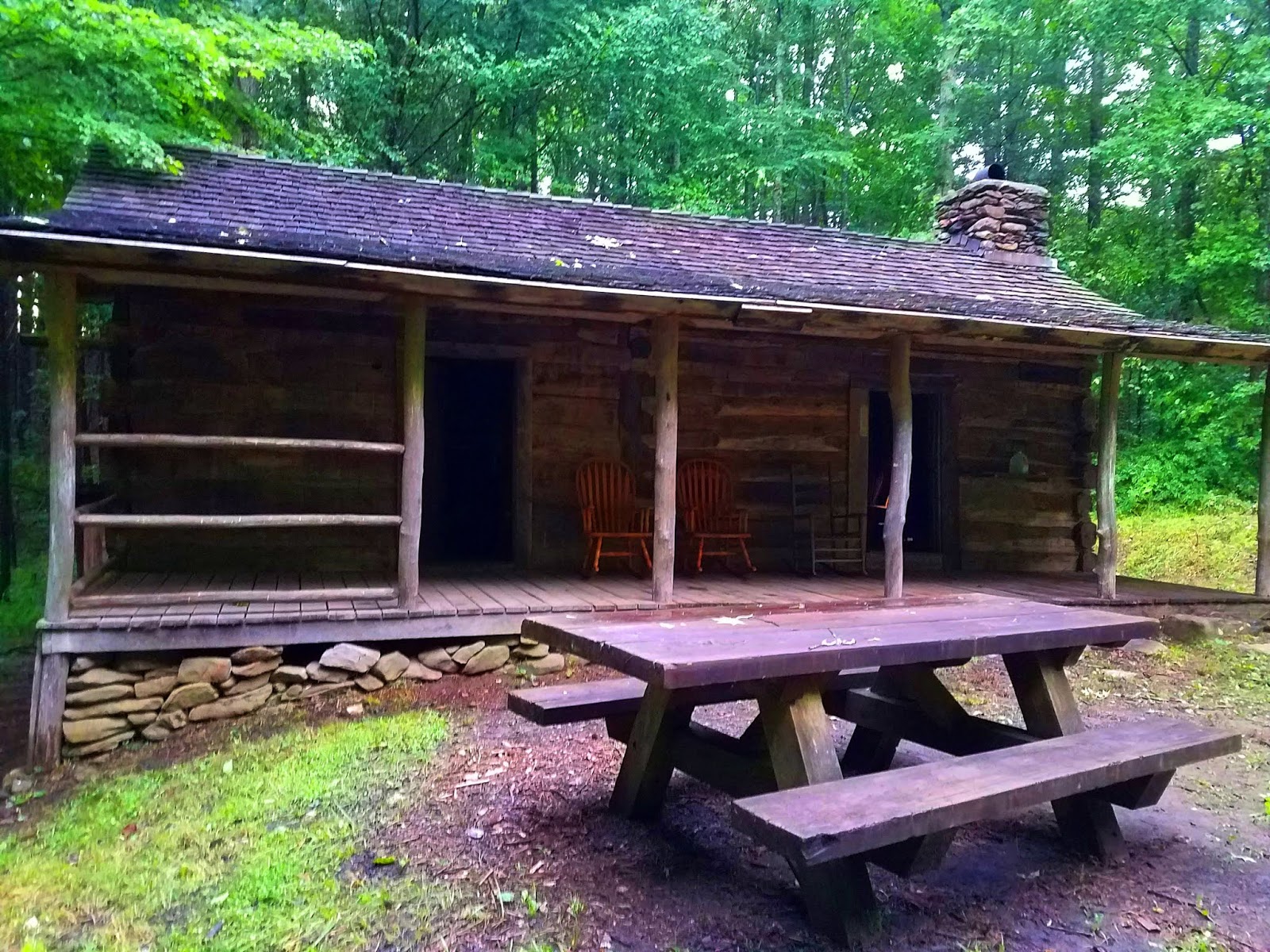
Set in a small clearing, Donley Cabin pre-dates the Civil
War. It consists of two rooms side by
side, each opening onto the eight-foot covered front porch. The room on the
right has a fireplace, a small window, a table and chairs, a double bed frame
with a plywood base, and a back door. It also contains four serious rocking
chairs that serve around the fireplace or on the porch. From there an interior
door leads to the second room (on the left from the front porch) containing 2
bunk beds with plywood bases and another small window. Rustic with a capital R.
If you’re thinking of going: The cabin does NOT have
electricity or running water. It is D-A-R-K inside even at midday. Good news,
it is maintained and cleaned for visitors, so the grass had been mowed, the
cabin swept free of spider webs, etc.


The privy had also been swept and supplied with a
roll of toilet paper inside a big coffee can. We were very appeciative of this
little building when it rained (which was all the time).
Time’s ticking and we’ve got a 10-mile hike ahead of us. Following
Mike’s advice, we’d start from Beaverdam Bald and hike a half-mile connector to
the BMT, then southbound to another connector leading to Waucheesi Bald where
Mike would park and hike in to meet us. He led us to the turnoff to Beaverdam Bald
before heading off to Waucheesi.

On the map it looked simple enough but…the drive up to the bald
was harrowing, rough, rutted, rocky, and Carol drove at a snail’s pace, understandably
very nervous about her car’s clearance. I regretted her driving and risking her
car rather than mine, even more so knowing that we’d have to drive back down.
No other vehicles at the bald, no cell phone signal either,
so we were on our own now. It was 2:30 p.m. and we were feeling the lateness of
the hour. Where’s that connector trail? A walk around the edges of the field
didn’t give any clues, so we walked back down the road until we saw a side
trail/old road bed. Maybe this is it? We followed this to another open field, smaller,
waist-high grass. [Yes, GAIA, AllTrails,
etc would have helped, okay, I get it.]
We walked through this little field and then around its perimeter
until we found a trail – Is this it?
Fingers crossed. If it trends down and to the left, it’s possible,
should only be half a mile, or we know the way back (up).

And…after much more than half a mile (too far?) we hit an
intersection with a big ol' sign (Brookshire Creek Trail and BMT) but
around the corner were two more trails with no indication what they were – could
this be the shorter route to the bald?
Not willing to hike up to find out, and no time to waste now that we’re
on our trail (3 p.m. and at least 9 miles to go!)


Hindsight check: Look
at the map again. What happened?
Trail maintainers call this remote section of the BMT the "Heart of Darkness" because it is hard to access with tools for keep Mother Nature in check. We can attest to this: the trail was so overgrown that we weren’t sure what to do –
go for it or call a retreat? Surprisingly, we found frequent white diamond blazes so we
pushed forward with Carol in the lead, tracking mileage with her Runkeeper as
we slogged along. We couldn’t see anything below our knees in the dense
undergrowth, sometimes shoulder height or taller, tangles of blackberry briars – kept our
long pants on despite the heat. Our hiking poles were defense weapons for
blocking foliage. Slow going, not a good feeling, having zero fun this
afternoon. The air tasted greenish, thick with humidity, and although there
wasn’t too much elevation, everything felt like a strain.


The only view – from Hazelnut Knob maybe? Colorful
names on the map but no signs, so we could only guess at where we were -
Sledrunner Gap, Rocky Top, Round Top, Nit Top, Hazelnut Knob, Moss Gap, Hipps
Gap
Yes, there were some bright spots: fire pinks and flame azalea


After five extra-long miles of tough hiking the vegetation
thinned a bit, but then thunder rumbled and the promised afternoon rain began. A steady downpour commenced for the
remaining five miles. We didn’t bother
with rain jackets because we are soaked with sweat anyway. When you’re wet,
you’re wet.
Meanwhile, how’s Mike doing, hiking in from Waucheesi Bald?
Will we meet up at Sandy Run Gap? Who the
heck knows where Sandy Run Gap is? At about 5:30 p.m. I spotted a sign in the
middle of the trail, a common practice of Mike’s, his initials “MD” shaped in
sticks. Encouraging! Mike had hiked to this point, waited a little while, then
turned around to go back to Waucheesi Bald to wait for us. Energized to pick up
the pace, we caught up to him about 20 minutes later. He gave Carol the keys to
his van and waved us on, saying he’ll be slower because it’s all uphill from
there.
The rest was a sufferfest, pounding away in the rain through
more stretches of tall foliage that was now drenched. Correction: when you’re wet, you can still
get wetter. At Sixmile Gap, the most
important signpost of the day, we turned right and commenced a half-mile steep finale
to Waucheesi Bald. I followed Carol, head down, counting steps.


We reached the van and were preparing to put on dry
clothes when Mike appeared. All present and accounted for. We left Carol’s car
for pickup tomorrow and headed back to Donley Cabin.
By the time we arrived at the cabin (8:30 p.m.), the rain had
mostly stopped. The sky remained overcast but amazingly still light. Carol and
I hung up clothes that will never dry, much relieved to have the cabin to
spread out in rather than a wet tent. Mike brought up his food and stove to
cook supper. I was too tired to cook, just
nibbled at random items from the cooler. At full dark Mike headed to his cozy
camper van.
Carol and I contemplated the likelihood of animals coming
inside the cabin at night. We moved the double bed frame to block the doorway
between rooms, leaving the front room doors open front and back, so if something
big were to come exploring we should hear it before we could touch it (or vice
versa). Note: this deterrent/alarm system
worked well for peace of mind.
Inside the cabin was can't-see-your-hand-in-front-of-your-face, utter pitch black; outside, the whisper of drizzling rain. Carol
heard mice throughout the night, but my ear plugs muffled all once I fell asleep, after
devoting time to worrying about tomorrow's plan - 16 miles.
"Live
your life by a compass not a clock." ~Stephen Covey
No comments:
Post a Comment