
Death Valley/Mt Whitney Trip – 9/10/11 – Gower Gulch/Golden Canyon Loop and Dante’s Peak – 8.8 Miles
6:00 a.m., rise and shine, no time for sleeping, we’re in Death Valley! No leisurely mornings of breakfast and a second cup of coffee (wait…where was the first cup?) for the Bergs on an adventure. Today we’re hiking to the lowest point of North America. What to wear, what to wear?
Packs ready, nerves jumping, we crept down the road toward civilization at Furnace Creek, a tiny oasis with a motel, gas station, general store, restaurant, a couple of campgrounds and the Visitor Center for Death Valley. This is as good as it gets, folks. Most important, we needed to fill up all our water containers and gas up the car ($5+ per gallon). Searching for water and gas became a theme for our time in DV.
Driving towards Badwater Basin, I could hardly believe my eyes. The sky ahead was dark and lightning flashed. I looked at Jeff – yes, he had seen it, too. The landscape was so wide open, it was hard to tell where the storm actually was, could be miles away or right over where we were planning to hike. And the tallest thing out there besides us would be some dead dragonflies.
Plans are meant to be changed, so we switched our itinerary, turned around and drove to Zabriskie Point on Highway 190, a popular stop for tourists-in-cars and a trailhead for a nice loop hike through Gower Gulch and Golden Canyon. We checked out the view from the overlook and then hopped onto the trail.
Plans are meant to be changed, so we switched our itinerary, turned around and drove to Zabriskie Point on Highway 190, a popular stop for tourists-in-cars and a trailhead for a nice loop hike through Gower Gulch and Golden Canyon. We checked out the view from the overlook and then hopped onto the trail.

How
to describe Gower Gulch? This was my first experience with canyon
hiking and everything was fascinating. A canyon is the path made when
water washes down from the mountaintops to the valley. Remember making
sand art as a kid, filling a glass bottle with layers of sand in
different colors? The mountains here are layers of all types of rocks,
layers of colors, not just yellow and red, but umber, ochre, sage,
magenta, bronze, sienna, slate, sand, taupe.


Signpost

Touching/tasting rock


Colors spilling down

An old mine

A harsh environment


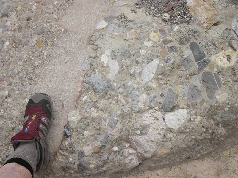
Breccia rock composed of broken fragments of minerals or rock cemented together - remember this when you redo your bathroom

Dolores looking at melted looking lava rock

Hiking babes
After
a couple of miles of wandering through this wonderland we exited Gower
Gulch near Badwater Road, which the trail paralleled for 1.3 miles up to
the entrance to Golden Canyon.

The first mile of Golden Canyon is an interpretative hike (alas, the fliers were gone from the trailhead.)

Golden Canyon narrows to a tight fit

And opens up

The trail splits and a side trip to the left for an additional .4 miles gets you to the Red Cathedral.

Red Cathedral from Manly Peak
Backtracking from the Red Cathedral, we turned left to catch the loop back to Zabriskie Point. The temperature and the trail climbed steadily and our morning jaunt became a little like work. This was a rude awakening from the pleasant walk down Gower Gulch. At 100+ degrees I dismissed everything I’d heard about “dry heat” because I was drenched in sweat. I was a little worried about the amount of water I was carrying (didn’t run out, though).
After a couple of miles of wandering through this wonderland we exited Gower Gulch near Badwater Road, which the trail paralleled for 1.3 miles up to the entrance to Golden Canyon.
After a couple of miles of wandering through this wonderland we exited Gower Gulch near Badwater Road, which the trail paralleled for 1.3 miles up to the entrance to Golden Canyon.

With a magnifying glass you can see the trail as it follows the base of Manly Beacon, an imposing feature amongst all the awesomeness. The panoramic views reminded me of the Grand Tetons without the snow. (My limited frame of reference is expanding!)

Fake background?

Getting warmer

A long view (Jeff's photo)
This section back to the beginning was 2.6 miles, making the hike a bit longer than Jeff’s original estimate. (Another theme emerging: distances are fuzzy out here *le shrug*). Considering that there were two more hikes on the day’s agenda, the wimpy part of me began scheming an escape.
Back at the car, no time for reflection, we can’t let Dante’s View get away! We ate lunch while Jeff drove with the HVAC at full power. Part of the Black Mountains, Dante’s Peak is above 5,500 feet and a welcome cool respite from Zabriskie Point. Jeff whittled down his original hike plan to just the one-mile round trip from the parking lot to the peak. The cool breeze and the expansive view of Badwater’s salt flats brought me back to my happy place.
From Dante’s Peak looking down into Badwater Basin, the lowest point, and across to the Panamint Mountains and Telescope Peak, the highest point of Death Valley NP. Yes, we’re going down there AND up there.
From Dante’s Peak looking down into Badwater Basin, the lowest point, and across to the Panamint Mountains and Telescope Peak, the highest point of Death Valley NP. Yes, we’re going down there AND up there.


Carolyn and Dolores
What’s that – one more hike today? Jeff’s research uncovered info for some little-known hikes, including Funeral Canyon. We drove back to Furnace Creek, filled up with water again, and found the trailhead (term used very loosely) at the Sunset Campground. Please note the time: 3:30 p.m. to begin an 8-mile hike.
The canyon began typically as a very wide washout, promising narrow slots and awesome/strange rocks to come. After about 20 minutes, I decided I’d rather chill/rest for tomorrow, so I bailed. Jeff gave me the car keys and they walked off into the wild. I went to the Death Valley Visitor Center.
At the VC I stood in front of the air conditioner for a (long) time, got my National Parks passport stamped and browsed the hiking books, ultimately buying Hiking Death Valley National Park (very useful in the days ahead). I had a long chat with the lady ranger, who did not want to give me advice about hiking in Badwater at this time of the year. She said it was dangerously hot and they steer people away from anything other than exploring the boardwalk there. I understood that she had to stick to a script, but it was frustrating to be stonewalled. I guess they get tired of rescuing people.
At the general store I got a sandwich and a COLD soda, then went back to the campground to wait for my valiant companions. With lots of time, I repacked my stuff, rinsed out socks in the bathhouse, read my book, and felt no remorse for opting out of the hike. They got off the trail about 7:10 p.m. and, yes, the hike was longer than they expected. I was fine with my 8.8-mile day. Jeff noted that we'd been in Death Valley only 24 hours and I'd already had my "town day."
Dinner at Furnace Creek Restaurant (no need for a fancy name when you’re the only one there) was excellent. Then we faced the hour-plus drive back to Thorndike Campground. I crawled into my tent at about 10:00 p.m., and before I could lie down I saw lightning flashes and heard rumbling coming over the mountain range, what turned into the most powerful storm I have ever encountered while in a tent. Dolores and Carolyn and I were tented close together, and Carolyn yelled that water was flowing swiftly underneath her. I said, “I’m not looking,” because I couldn’t do anything about it anyway, but I could see that my tent floor was squishing like a waterbed, too. I sat up with my little headlamp, constantly checking for leaks. The rain splashed hard enough on one side to plaster the rain fly to the netting, so I got a little wet, but for the most part it held up really well (Big Agnes Seedhouse 2). [Carolyn’s tent really was swamped and she renamed it “A River Runs Through It.” We moved it to level ground the next morning.]
Three quick lightning/thunder cracks directly overhead had me saying my prayers that the stunted tree over my tent wouldn’t lose any branches. There wasn’t much wind, but the rain pounded hard, and then the storm passed. There was more rain during the night.
Average annual rainfall in Death Valley: two inches. I guess that doesn’t include the mountains surrounding it.
No comments:
Post a Comment