(Read Danny’s thoughts about today’s hike here.)
Bad weather was still threatening and now the concern was icy roads involved in shuttling. I think Danny and I were still a little bit in denial as to the degree of difficulty in planning ahead during these winter months. The compromise de jour was hiking the MST section from the Folk Art Center (where we ended the previous day) eastward to Bull Gap. Danny’s husband, Lenny, helped us set up this shuttle and we started off from the Folk Art Center, ready for a rain-filled day. And once again the weather forecast was off.
While temps were certainly cool, the rain held off. The hiking was more of what I prefer, rolling uphills and downhills and (mostly) out of sight and sound of the Parkway. Most likely the low amount of traffic on the BRP was due to its closure north of Craven Gap - few commuters or even si
 ghtseers today. In addition, the MST crosses the Parkway only a couple of times so here was the chance to stretch our legs and pretend we were in the wilderness. Every view, however, included houses on the neighboring mountains. Perhaps when the leaves are out one can be fooled into thinking the houses don’t exist.
The trail took us through gnarly mountain laurel tunnels, certainly beautiful during bloom season. There is beauty in the bare wood of winter too.
The mountainsides are steep in this section and as we paralleled the Parkway, it was sometimes 100 f
 eet above our heads or 100 feet below. As we crossed a stream below the road, we noticed this rusting barrel. Danny crawled up the bank and discovered a cavelike structure of stacked rocks. A former moonshining site?
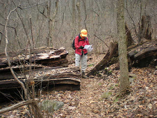
 “How the mighty have fallen.” How did this old grandfather tree meet its fate? Rotting from the inside out, followed by a wind storm or an ice storm giving the final push? The MST trail builders cut through it and kept going.
Someone out there can probably tell me what these brown puff ball shapes are at the base of this tree. One poke with a finger and they imploded with a powdery whoosh.

One long uphill brought us to Lunch Rocks, so named because it’s a good place for a pause and a snack. Here was a reminder of our proximity to humans as it overlooks a road and an Asheville neighborhood.
This was my first experience hiking while wearing blaze orange during hunting season. Although we were walking on protected land, the BRP corridor is narrow and it is possible for hunters and bullets to trespass unintentionally. We met a few dayhikers out today, one of whom took this photo as we paused at Craven Gap. What they did not realize is that we had both taken a trail break about two minutes before they came on the scene. Don’t ever assume you are alone on the trail!

At Craven Gap we crossed the road and climbed high above the Parkway. The trail wandered through boulder fields and up these wonderful steps made by the CMC trail builders. About a mile from our end point the rain began, light at first and then in earnest. We put on rain gear and hustled along, grateful that we had not had to walk in a downpour for the entire day.

It’s always good to see my car right where I left it.
A wonderful consolation for our short day – Danny and I had a delicious dinner at a Japanese restaurant and attended an author’s presentation at Diamond Brand in Fletcher, NC. William Hart, Jr., author of 3000 Miles In The Great Smokies, gave an informal and delightful talk and it was truly a thrill to hear him read his work. Mr. Hart has hiked in the Smokies for decades and kept a detailed diary of notes of every experience. His book is a compilation of thoughts and reminiscences of his wonderful days and nights there.
Postscript: Danny and I had plans to hike a long section of the MST the next morning, studying the weather forecast late in the evening and again early in the morning, but ultimately decided to cancel because of predictions of rain, ice, snow, sleet and poor road conditions getting to the trailhead. I headed home. In the flatlands near Charlotte the skies were blue and harmless, but we learned later that there were many downed trees on secondary roads and the Parkway was now closed, probably until April, so we made a wise decision. But what will we do until the spring thaw?
Bad weather always looks worse through a window. ~Author Unknown

1 comment:
Interesting blog you got here. I'd like to read a bit more concerning this topic. Thanks for sharing this material.
Joan Stepsen
Gadget products
Post a Comment