
We did a little backtracking this morning to get Jim as close to the detour spot as possible where he left off the day before, and then I sailed on my way down the Parkway, passing over the famous Linn Cove Viaduct. The end point of the day was in Little Switzerland and there were hard choices to be made for hiking. Price Park? The Tanawah Trail? Grandfather Mountain trails? Linville Falls? Ultimately my criteria was short hikes with big payoffs that I may not choose to drive all the way from Charlotte to visit at another time, so all of the above areas were off the list since they are worthy all-day or even weeke
 nd destina- tions. What’s left? Beacon Heights, of course.
Beacon Heights is considered a leg- stretcher stop on the BRP, a round trip excursion of .7 miles to two exfoliated rock domes. The Mountains-to-Sea Trail rubs up against this trail so it is possible to do a loop or shuttle hike for more miles. However, I was here for the view and was not disappointed. As on most of my hikes during this adventure, I had the place to myself. The view to the southeast - the two pointy peaks th
 at look like cat’s ears are Table Rock on the left and Hawksbill on the right.
And my second destination – Hawksbill Mountain. Using both of my guide books, “Hiking North Carolinas' Blue Ridge Heritage" and “Hiking the Blue Ridge Parkway”, I detoured nearly nine miles off of the Parkway in search of this intriguing landmark, through a lovely mountainside community and onto a gravel road for a bit, until I finally found the parking area. There were two young women there with backpacking gear strewn all around, sorting things for an overnight trip. I left them and started climbing the well-worn trench. The first part of the trail is ro
 ugh and eroded, with water bars that are quad- busters, but it eventually becomes gentler. Both guidebooks give good instructions for navigating in this unsigned wilderness, but there was a little help for the most important left turn.
At the end of the trail the world opened up and – WOW! As Danny Bernstein says in her book, “For a less-than-two-mile walk, this hike has to be the ‘best value for your walking buck.’” Hawksbill is a large expanse of exposed granite, occasionally interrupted with low pines and sand myrtle growth, and featuring a panoramic view into Linville Gorge. I've heard the Gorge described as the Yosemite of the East and it
 was easy to see why. Here is a close-up of Table Rock Mountain and the Linville Gorge. Alone as usual, I sat and ate my lunch on this flawless day, although I could barely chew because my mouth hung open at all that was spread out below me.
Here’s the “duh” moment for you all who have been to Hawksbill before – as I turned to leave, I noticed a distinct path (actually a few paths that all led in the same direction) through the sand myrtle and followed it…up to the REAL summit of Hawksbill! I had just spent a half hour marveling at the previews and here was the main attraction! Linville Gorge wa
 s up close and personal and Grandfather Mountain lay snoozing in profile to the north. I met two very nice gentlemen there (names are gone with the wind), one a local and the other his visiting cousin from Seattle. The local fellow (Charlie?) offered to take my picture in just the right spot. Good choice, dontcha think? That’s Grandfather Mountain in the center of the ridgeline. Hawksbill is just awesome, a place that I will return to. Wh
 at a perfect day to be there!
With these two short hikes under my belt, I still had time for one more hike and a different type of highlight – Crabtree Falls, the jewel of Crabtree Meadows Recreation Area, a few miles past our home for the night in Little Switzerland. Near Milepost 339, this area includes a Visitor Center (open!), a gift shop, a snack bar and a campground. The campground was pretty deserted, but there were other people on the trail, although not the crowds
 that I suspect splash around in the pool at the bottom of the falls during the summer. The down side of Crabtree Meadows (for me) is that there are no other trails. But the 2.5-mile loop trail to the falls was a pleasant walk, going down, down, down, and this is the payoff:
On the return half of the loop, Jim called and was at our meeting point, the Mineral Museum (a rarity for him to finish ahead of me), so we agreed to meet at our hotel located directly on the Parkway, the Switzerland Inn. And what a pleasant surprise it was! I had no complaints about our accommodations up to this point, but this was high living. Our room was enormous, enough space for Jim to have his own staging area (have I mentioned that he brought his bike into the room every night?). The hotel lobby was one of those grand old spaces with groupings of
 leather sofas around fireplaces and chairs facing the wall of windows overlooking the patio and the mountain view beyond. And…hold on a minute…what’s that beyond the patio??? I’m trembling…it’s a HOT TUB!
With a chill in the air (the best time for a hot tub) we soaked and drowsed until it was time to think about cleaning up for dinner. Our meal at the hotel restaurant was five-s
 tar. Now, what could possibly make this place better? Well, wireless, of course! The connections were a little sketchy in our room, but out in that luxurious lobby we stretched our feet out on the coffee table and wasted some time online and then reading good books.
Yep, we could get used to this hiking and biking life…uhh, I think we already have…
Jim’s Day Six
Well, it is sounding like a broken record….the day started out cool, sunny and clear. Another gorgeous day to ride. I was so fortunate with the weather on this trip. SS dropped me off on the southside of the detour around the Goshen Bridge somewhere around mile 288 or so. She met me on the north side yesterday at the end of day. In order to get as many miles on the BRP as possible I rode from the detour gates north to the bridge itself this morning. It was 3 or 4 miles one way. This was the only time on the whole trip that I traveled any appreciable distance heading north. Of course, since I was headed towards a bridge it was all downhill and then uphill when I turned around. Whenever a bike rider sees a “Bridge Freezes Before Road” sign on a country road he knows he will soon be heading downhill to a stream, brook, etc. and then back uphill. And yes, the bridge was out when I got there. 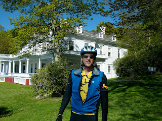
After retracing my ride back to the starting point for the day I was headed for my first stop at Moses Cone Park. I made it quick. I took a picture of mother and her young son outside the mansion and they returned the favor. I did that a lot on the trip. If I saw a group of people together I asked them if they would like a picture of them together and then they would take a picture of me. Otherwise I would not have many pictures of me. A win – win. These cows weren’t interested though.
I then headed to Julian Price Park and the Linn Cove Viaduct. I had done the ride from Moses Cone to the Viaduct and back about 2 ½ years ago. It was humbling to me then. It is a challenging ride and includes a climb of over 1000 feet among other smaller ones. I was interested in how it would feel now after training a lot more. I did make a quick sweep through the Price Park campground looking for Ben and Jack. I knew that was their destination yesterday. No luck though. I’m sure they had already hit the road. The ride to the Viaduct was great, challenging for sure but much easier than last time. I crushed it. (That is my term for doing well on a ride.) The views were spectacular.
The Viaduct itself is suspended on the side of Grandfather Mountain and makes for a great picture on a clear day. I did a quick ride through the overlook just before the Viaduct to take a look at a small waterfall. It was nice but even more interesting was a group of 7 brothers and sisters ranging in age from about 3 to about 10, all with red hair and freckles. They were on a classic family road trip vacation. I thought it was real cool and told them so. They reminded me of SS and her dad.
After the Viaduct there is a long gradual downhill to Linville Falls. I kept thinking that it would end soon but it went for well over 15 miles. I got into a tuck on some of the steeper and straight parts to see how fast I could get. I topped 40 mph but not by much. I had a quick lunch at the Linville Falls picnic area. I was surprised that it was deserted. Just me and my bike.
Views, views and more views on the stretch from the picnic area to the Alta Pass. There is just not a bad view on the BRP. There is a famous orchard and store at the Alta Pass. I was hoping to visit it and get a snack (apple pie ala mode maybe?) but the road leading to it was long, steep, downhill and gravel. Da ng, my bike could not handle it nor would my hard soled cycling shoes be any good. So much for that. I got on my way and headed for my rendezvous point with SS, the NC Minerals Museum at about mile marker 331. I made it there well ahead of schedule for a change. I called SS and she told me that she was late so we decided I would just head on up to the Switzerland Inn located in Little Switzerland, our place for the night. It was a quick 2-mile climb and no problem. I felt pretty strong all day.
The inn itself was great. Beautiful views in an Alpine atmosphere. This was our splurge accommodations for the trip. The grounds included a large swimming pool and dual hot tubs. SS and I lounged in the hot tub and around the pool for an hour or so in the afternoon. Dinner was at the accompanying restaurant and was our fanciest meal of the trip. Although rooms have TV, internet, etc. we spent most of the evening in the large lobby area. This is one of those lobbies meant to be a gathering place. It has two fireplaces, sofas, lots of tables for board games and a large wall of windows for looking at the mountains. It was chilly enough that the staff had a fire in one of the fireplaces. I had washed a load of cycling gear in the tub and hung it by the fireplace to dry. It was kind of tacky but also funny and practical.
Stats for day:
Mile marker start: 288 or so
Mile marker finish: 334
Total day miles: 53.6
Climbing for day: Still need to get this
Avg speed: 12.7 mph
Max speed: 41.1 mph
The sound of a car door opening in front of you is similar to the sound of a gun being cocked. ~Amy Webster

After retracing my ride back to the starting point for the day I was headed for my first stop at Moses Cone Park. I made it quick. I took a picture of mother and her young son outside the mansion and they returned
 the favor. I did that a lot on the trip. If I saw a group of people together I asked them if they would like a picture of them together and then they would take a picture of me. Otherwise I would not have many pictures of me. A win – win. These cows weren’t interested though.
I then headed to Julian Price Park and the Linn Cove Viaduct. I had done the ride from Moses Cone to the Viaduct and back about 2 ½ years ago. It was humbling to me then. It is a challenging ride and includes a climb of over 1000 feet among other smaller ones. I was interested in how it would feel now after training a lot more. I did make a quick sweep through the Price Park campground looking for Ben and Jack. I knew that was their destination yesterday. No luck though. I’m sure they had already hit the road. The ride to the Viaduct was great, challenging for sure but much easier than last time. I crushed it. (That is my term for doing well on a ride.) The views were spectacular.

The Viaduct itself is suspended on the side of Grandfather Mountain and makes for a great picture on a clear day. I did a quick ride through the overlook just before the Viaduct to take a look at a small waterfall. It was nice but even more interesting was a group of 7 brothers and sisters ranging in age from about 3 to about 10, all with red hair and freckles. They were on a classic family road trip vacation. I thought it was real cool and told them so. They reminded me of SS and her dad.
After the Viaduct there is a long gradual downhill to Linville Falls. I kept thinking that it would end soon but it went for
 well over 15 miles. I got into a tuck on some of the steeper and straight parts to see how fast I could get. I topped 40 mph but not by much. I had a quick lunch at the Linville Falls picnic area. I was surprised that it was deserted. Just me and my bike.
 Views, views and more views on the stretch from the picnic area to the Alta Pass. There is just not a bad view on the BRP. There is a famous orchard and store at the Alta Pass. I was hoping to visit it and get a snack (apple pie ala mode maybe?) but the road leading to it was long, steep, downhill and gravel. Da
 ng, my bike could not handle it nor would my hard soled cycling shoes be any good. So much for that. I got on my way and headed for my rendezvous point with SS, the NC Minerals Museum at about mile marker 331. I made it there well ahead of schedule for a change. I called SS and she told me that she was late so we decided I would just head on up to the Switzerland Inn located in Little Switzerland, our place for the night. It was a quick 2-mile climb and no problem. I felt pretty strong all day.
 The inn itself was great. Beautiful views in an Alpine atmosphere. This was our splurge accommodations for the trip. The grounds included a large swimming pool and dual
 hot tubs. SS and I lounged in the hot tub and around the pool for an hour or so in the afternoon. Dinner was at the accompanying restaurant and was our fanciest meal of the trip. Although rooms have TV, internet, etc. we spent most of the evening in the large lobby area. This is one of those lobbies meant to be a gathering place. It has two fireplaces, sofas, lots of tables for board games and a large wall of windows for looking at the mountains. It was chilly enough that the staff had a fire in one of the fireplaces. I had washed a load of cycling gear in the tub and hung it by the fireplace to dry. It was kind of tacky but also funny and practical.
Stats for day:
Mile marker start: 288 or so
Mile marker finish: 334
Total day miles: 53.6
Climbing for day: Still need to get this
Avg speed: 12.7 mph
Max speed: 41.1 mph
The sound of a car door opening in front of you is similar to the sound of a gun being cocked. ~Amy Webster
2 comments:
Wow, Hawksbill looks awesome, I'll have to check that one out! Yosemite without the billions of people. Great shot of you hanging on the ledge.
Yes, Hawksbill was truly the highlight of the day. And there are other hikes in the vicinity to combine with it for a nice day, such as Table Rock and Shortoff Mountain.
Post a Comment