Thursday, January 6, 2011

Pause + Thanks + Deep Breath + Move On

MST – Day 32 – 9/26/10 – Table Rock Picnic Area to Highway 181 - 9.9 miles

Here’s a proven mathematical formula for you: the quantity of time spent planning to hike a complicated trail section is directly proportional to the probability that the plans will be thwarted. The more planning, the better chance it ain’t gonna work out.

Danny spent a considerable amount of time looking for hiking partners for the Linville River section of the Mountains-to-Sea Trail. We’d already scratched one plan to do this section back in the summer. Then a stroke of luck: Carolina Mountain Club scheduled a key swap hike for this section which suited us perfectly, lots of people to help shuttle, cross safely, and we wouldn’t have to do an out-and-back hike (i.e. cross the river twice.) This hike was planned for a Sunday and we schemed to add three more hiking days afterwards to really knock out the miles.

Kate Dixon, avid hiker and executive director for the Friends of the MST, signed on for the experience. We were excited to have Kate along as another person for safety and someone new to talk to (face it, after all these hours Danny and I know each other’s jokes).

Jim, my cycling husband, signed up for the Cycle North Carolina ride for this same time frame. Why do I tell you this? Because I had to deliver him to Biltmore House in Asheville, NC for the start of his ride, coordinating nicely with my arrival at Danny’s home on Saturday night. A good dinner, a good night’s sleep, and we woke up ready for the river.

So what’s all this rain about?

Due to the torrential downpour in the area, the hike leaders wisely canceled the hike in the wee hours of Sunday morning – too much water for safe navigation across Linville River. So do we have a Plan B? Of course we do! We have four days of hiking planned so we can just substitute one day for another…sort of. Danny, Kate and I set off in three cars for Table Rock. Going through the driving rain, I thought about Jim and his buddies cycling on the back roads…yikes.

For our alternate plan we set up a shuttle to hike from the Table Rock picnic area to Highway 181, really the end of our original Linville Gorge scheme. Hitting the trail from the picnic area we were suited up for continuing rain, but we soon removed our layers and ended up with no real rain at all except for a slight drizzle for the last hour that was not worth putting rain gear back on. We experienced yet another great hiking day for the memory banks, a cool, easy trail with a couple of brief uphills and awesome water features.

Flower of the day – gentians


Sometimes we take snack breaks at spectacular views or beside gurgling creeks, but most often we take them according to the clock or our stomachs. For example, we look forward to “elevensies” for a little something-something to tide us over till lunchtime, which is often after 1:00 p.m. If we find ourselves stopping often, we may call it “second breakfast,” “first lunch,” “second lunch,” etc. (On rainy days we take very few breaks because who wants to sit in the rain?) All that is required for a break is a little patch of sunshine (or shade, depends) and a log to sit on…or maybe not. Sometimes we just plop down on the ground inside a rhododendron tunnel and go for the food.

Today at a snack break at a nondescript spot on the trail, I told Kate about the feeling I get when I stand up to leave such a place. While we’re sitting, eating, chatting, packing up again, I don’t feel it, but in that moment before beginning to move, I pause and acknowledge that I will probably never be in that place again. Try it the next time you’re on a hike. Close your eyes, be grateful, take a deep breath, and start walking. LOVE IT.

 Trail conditions varied from cushiony pine needles to numerous wet slippery rocks. Kate was happy to see the great trail maintenance and blazing. As ED of the FMST, she channels many inquiries and comments about trail conditions and always knows the latest on trail building efforts. If anyone is interested in thru-hiking or seriously section hiking the MST (or trail building/maintaining), connecting with Kate can be very helpful. There, I just increased her work load – she’ll love it! Check out the FMST website.

  About 5 miles in we crossed Buck Creek and then began following Steels Creek – gee, it’s already time for a “second lunch” break, this time on big rocks beside a nice cascade. There are huge waterfalls farther upriver but we did not take the very steep side trail because it looked like a mud slide. In this area we passed two young guys and a young woman who were soaking wet, said they had been playing in the waterfalls and were heading back to their campsite.
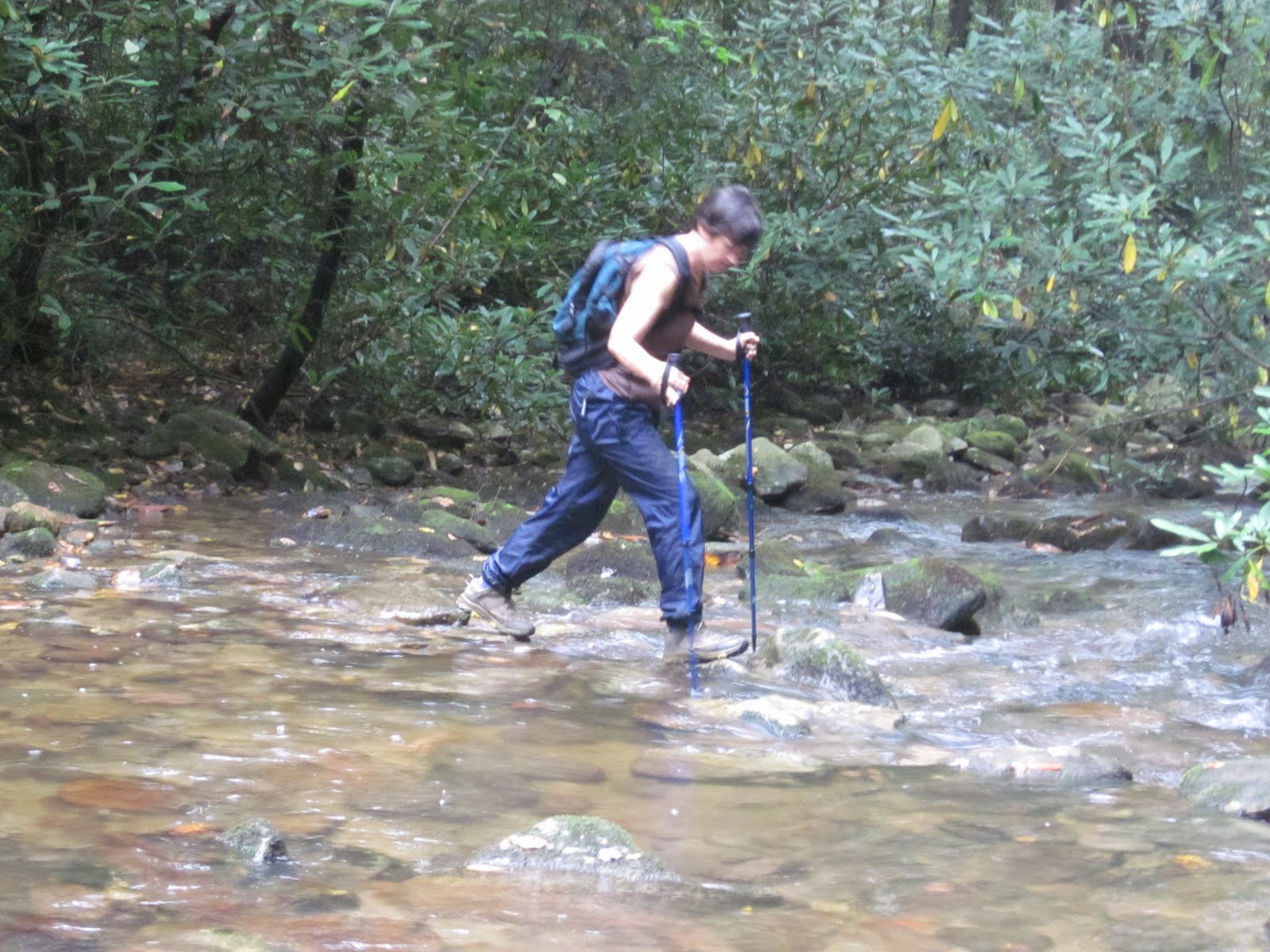


Kate crossing a creek


Near the day’s end Scot Ward’s book cautioned us to “be careful” crossing a waterfall. Scot does not often embellish directions, so when he does we pay particular attention. Sure enough, this cascade went off an infinity-like edge into oblivion and we had to walk directly across the slanted and slippery rock face about 10 feet from the edge. Someone had strung a rope across it to hang onto, anchored on both sides, but using it meant pulling it taut and walking through a deep, murky pool. As much as I like creek crossings, the most dangerous thing is usually slipping and getting wet. At this cascade the danger was in slipping and going over the edge and down a few hundred feet. We all made it, of course, but I wouldn’t sign up to do that every day. (Credit goes to Kate as the photographer here.)

Would you trust this rope?


Wave bye-bye


Me starting out


Danny tries out the rope


During the hike we tossed around alternate scenarios for the remaining hike days and I think we did a pretty good job of planning on the fly. After we reached 181 we made a mad dash back to my car at the Table Rock picnic area to get my stuff and then left the car there for the next day’s hike ending.

Accommodations were a special treat: my friend Diane’s cozy cabin near Linville Gorge. It was absolutely wonderful to have a place to spread out wet stuff and get warm and dry. Everyone had their own room and there was even electricity and hot showers! Sigh…….

Click here for Danny’s writeup of the hike.  

When late morning rolls around and you're feeling a bit out of sorts, don't worry; you're probably just a little eleven o'clockish. ~ Winnie the Pooh

Tuesday, January 4, 2011

Mountains To Seal Trail: Cascades and Infinity Pools - Beacon Heights

MST – Day 31 – 9/16/10 – Forest Road 464 to Beacon Heights - 10 Miles

It’s dark-thirty a.m. as we sneak out of Mortimer Campground – back to Forest Road 464 to start our second day in Wilson Creek. Danny has hiked some of this section before and it’s part of a loop hike from her second book. I am pumped up because the weather is clear and again we will be following the streams.

We carry photocopies of the relevant pages from Scot Ward’s book on every hike and follow along with his notes. In Wilson Creek we tried but soon lost track of each campsite and stream crossing, although if we were backpacking we would pay more attention to these.

The first half of the hike is spectacular, discovering waterfalls and swimming holes. First is Hunt-Fish Falls, a little over a mile in, and the easy access is confirmed by an old lawn chair left for our lounging pleasure. Personally I’d rather sit on the rocks.
 
I am always fascinated by ferns growing on the tops of rocks.


The trail hugs Lost Cove Creek, then turns left to follow Gragg Prong. We watched closely for Scot’s instruction of a “side trail to waterfall on left (worth it!)” and marveled at this unnamed cascade. Imagine the roar of the water flowing past my boots…


…and on down the rocky gorge.


For better or for worse, there are established campsites all along the trail. Better: fire rings. Worse: trash in the fire rings. The longest walk to any of these sites is 2.5 miles from access roads so you can haul just about anything in. Danny and I debate blaming the locals for not taking care of their home turf. Is it a fair assumption that the local folks are the abusers? Whoever the culprits are, seeing the trash at site after site makes me think twice about camping in this area on a weekend unless I’m looking for a party.


A little Zen at one of the pools.


The third big surprise water feature was actually several “infinity pools” flowing into each other – pure heaven on a scorching hot day. The kids can have their own pool with the grown-ups nearby.

After hopping little creeks a few more times we crossed Gragg Prong on a very nice bridge and stepped onto Forest Road 981 at a tangled intersection of gravel roads. A scratch of the head and then the appearance of a white blaze put us onto Forest Road 192 for a three-mile uphill climb. Danny enjoyed the road walk because we could walk side by side and chat more – and we did make good time on this section – but I still prefer a trail to even a dirt road. One bright spot was a small cascade that we named “Sharon Danny Falls.” You can name a star after a person, so why not a waterfall out in the wilderness?

At Old House Gap we took a sharp left off the forest road and began a steep straight uphill climb. Instead of a nice woods trail, though, I had the feeling of walking up a narrow cut for a power line (but no wires in sight). Oh, well, at least the sourwoods were turning red, broadcasting that fall was nearly here.

Back into the woods, the trail twisted and turned ever upward toward the Blue Ridge Parkway. As we got close to Beacon Heights, I heard a very loud snuffing noise to my left. What was that? I stopped, looking over my shoulder to see that Danny had stopped too (at first she thought I was just blowing my nose). I heard it four more times but couldn’t catch a glimpse of the animal. I concluded that it was probably a 15-foot, 500-pound black bear guarding 8 cubs and that we had narrowly escaped certain dismemberment and/or death…or it could have been a really hefty squirrel

Hikers at rest


Many varieties of goldenrod are everywhere


A break in the trees - this looks like Hawaii to me...never been to Hawaii...


A scant mile from the Beacon Heights overlook, the side trail appeared to the parking area where our car patiently waited. That always-long drive home convinced us to skip the diversion to the overlook and we opted to call it a day. Two nights and two days in the wilds of Wilson Creek were a highlight of my MST adventures so far...and I was ready to go home.

Read Danny's story of our day here.

Every leaf speaks bliss to me, fluttering from the autumn tree. ~Emily Bronte

Sunday, December 12, 2010

Deep In The Heart Of Wilson Creek

MST – Day 30 – 9-15-10 – Highway 181 to Forest Road 464 – 14.3 Miles

Time to get back on the Mountains-to-Sea Trail with Danny. Our Linville Gorge plans were thwarted back in June and for the time being we chose to skip that section as we revised our strategy. Little sister to Linville Gorge, very scenic and nearly deserted in mid-September is the Wilson Creek area. My son and husband talk with misty eyes about Boy Scout expeditions to Wilson Creek, waterfalls, swimming holes, grilling steaks that they have backpacked in. I was finally going to see it!

Danny and I met at Mortimer Campground as our base camp for hiking in Wilson Creek, a nice little spot with hot showers and flush toilets and a couple of serious compounds set up with pop-up campers and tarps galore. How do you get to Mortimer Campground? Well, just take Brown Mountain Beach Road for a few miles after it turns to gravel and turn left at 90. This area of our great state of North Carolina has not seen pavement. Most all of our driving while based at Wilson Creek was kicking up dust and gravel.

Our first hike began from Highway 181, the main road from Morganton, NC up to the Blue Ridge Parkway. 181 is a sort of dividing line between Linville Gorge and Wilson Creek. And believe it or not, we are still in Pisgah National Forest. National Geographic Map #779 for Linville Gorge/Mount Mitchell is essential for hiking this area. Some trails have names per the map and there is intermittent signage. As always, the white dot blazes were a lifeline for us, even on fallen trees.


An amazing view of Grandfather Mountain - we will continue to spy on the old man for the next 150 miles


 Bowman's root


Pink turtleheads


 Cardinal flower


Wilson Creek is a wilderness area and camping is allowed. Scot Ward’s book points out established campsites – they are numerous and well- situated. The key feature of this neck of the woods is water, water and water. Ironically, we never hiked along Wilson Creek itself, but we became intimately acquainted with Upper Creek, Raider Camp Creek and Harper Creek. Scot also notes many fords, and when Scot says “ford” he means wet feet. We decided to skip carrying water shoes and go all in – the day was very hot and the water would be refreshing. Because of the relatively dry conditions I was able to rock hop more than a few but four of them got the better of me. One was up to the hem of my hiking shorts and even higher on Danny.

Do you see the gator
lurking at the surface?


One of many pools along the way


Today was an easy hike for the most part as the trail switched between easy track, deep trenches and old roads. We made one small mistake and kept straight but soon backtracked to a left turn, where the trail changed character, becoming very narrow and steep – more interesting but more treacherous – or is it more interesting BECAUSE it’s more treacherous?

We ended the day at Forest Road 464, yet another gravel road.


Old railroad tracks from logging days


Busy beavers create dams along Harper Creek


 Yellow jacket nests were everywhere along the trail


What a hidden treasure - an unnamed waterfall on Harper Creek.


Wilson Creek exceeded my expectations, maybe because I love hiking along creeks, maybe because the skies were blue and the sourwoods were changing to red, maybe because we were still catching some late bloomers – or maybe I was just happy to be back in on home turf. There is no place like the North Carolina mountains.

Read Danny's story about the day here.  

Sometimes, if you stand on the bottom rail of a bridge and lean over to watch the river slipping slowly away beneath you, you will suddenly know everything there is to be known.~ Winnie the Pooh

Wednesday, December 1, 2010

Sea Caves

Apostle Islands National Lakeshore Trip – 9/4/10 - Day 8 – Lakeshore Trail at Meyers Beach - 10 miles 

The last day of this big adventure at Lake Superior. First stop: Gruenke’s for breakfast! A different table, totally new view of the restaurant’s atmosphere, fantastic veggie omelets and fluffy pancakes. Now we were fortified for a trip to the Apostle Islands Visitor Center.

We were curious about the sea caves that we had missed on our kayak day. At the VC we saw an excellent slide show of the sea caves visible from the Lakeshore hiking trail at Meyers Beach – decision made! The rangers described the hike as muddy (maybe for normal people but not for us) and the turnaround at about three miles (again, for normal people but not for us – we stretched the six-mile out-and-back hike to ten miles).

The Apostle Islands are an archipelago, an island chain, of 21 islands. The steep sandstone walls of the mainland fronting on Lake Superior along Meyers Beach and on some of the islands can rise over 50 feet above the lake. Sea caves are carved from the sandstone by the relentless wind and waves and ice. Formations called windows and arches are also formed on sandstone that juts out into the lake. Sea stacks occur when the sandstone rock erodes between closely spaced joints. Click here for more info and great photos of sea caves.

The Lakeshore trail undulates around curves, at times jutting out into the lake to look back at the caves, at other times skirting the edge of the cliffs:

Sea caves (photo by Jeff)


Me on the edge of a cliff


Neil on top of an arch


A window


Wonder how that tree is hanging on?


Mike on top of a cave - would have been awesome to paddle in and out of them


Sea caves


Eventually the trail swung away from the shoreline (turnaround time for the normals) and we followed the trail looking for its end point on our map, near a backcountry campsite… or is it a beach? Or both? At this beach we took a lunch break and then some of us turned back while some looked for the connection between the beach and the alleged backcountry site.

 By the time we regrouped back at the cars the day was fading and we went back to Bayfield in search of our last meal. This being Saturday night of Labor Day weekend, a few thousand other tourists were also hungry so we had some wait time before we pulled up chairs to our table at Maggie’s. Our server was an older gal who needed a night off, but otherwise Maggie’s was lots of fun, especially if you like flamingos everywhere. Great food, a beverage or two, and then it was time to retreat to our luxurious cabins and cram stuff into duffel bags for the flight home.

Our North Shore/Isle Royale/Apostle Islands trip was a unique adventure that just gets better with the telling. I am so very fortunate to have the time, money, health, energy, friends and understanding spouse combo that makes it possible for me to enjoy these wonderful national treasures.

How to shake the let-down from a fabulous trip? Get back on the Mountains-to-Sea Trail!

 “Take nothing for granted. Not one blessed, cool mountain day or one hellish, desert day or one sweaty, stinky, hiking companion. It is all a gift.” ~ Cindy Ross, Journey on the Crest, 1987