Tuesday, September 23, 2014

Adventures in Peru - Phutupatamarka, Intipata, Wiñay Wayna - Just Plain Awesome


Adventures in Peru – 6/12/14 – Land of Enchantment - Chaquiqocha to Wiñay Wayna – 9km

The day starts off luxuriously, sleeping in until nearly 6:00 a.m.  My cup of coca tea warms my hands this morning, temp seems to be in the high 40’s.  We will only hike until lunchtime and then…oh my gosh I can hardly contain myself…we have the afternoon off.  I feel a nap coming on.

Breakfast?  My appetite is still missing in action, but I try to eat some toast and yogurt with fruit.  There is also an egg-and-diced-veggie scramble.   It is not my habit to eat breakfast at home until after I’ve been up for a couple of hours and had a workout.  I carry a couple of Clif bars to try to nibble on today.  As part of packing up, we remember that our sleeping bags and mats and other stuff goes back in our own backpacks today. 

Looking back at camp

Looking ahead  

Vamos!  Still at 12,000 feet, the slightest upward incline is torture.  How long do you have to live at high altitude to become acclimated?  Soon we arrive at the Inca Tunnel, a 12-meter rock tunnel with steep steps (are there any other kind?), fun to hoot and holler as we descend.


Andy at the bottom of the tunnel

Of course we have more climbing up to the third pass of the Inca Trail.  We need a rest at the top, but first let’s pose on top of this big rock.

Our shadows (aren’t we clever?)


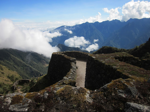
Just below the pass is our reward:  the ancient site of Phuytupatamarka, “City Above the Clouds.”  The structure of this site is unusual, a pyramid of seven terraces linked by a straight stairway.  On one side is an intricate series of ceremonial baths connected by water channels.  Archeologists opine that these were probably not used for washing in but intended for use in the ritual worship of water.  It is the best example we’ve seen so far of how the Incans captured and distributed water.  The site probably supported hundreds of people.


Temple of the Sun at Phuytupatamarka


Below the site we step onto a spiral staircase, each step carved out of the bedrock.  One huge boulder has more than 30 steps cut into it.  We wind down into the cloud forest, a lovely wooded respite, and tiny flowers seem to drip from the sides of the mountain. 

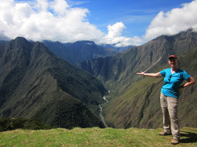
Time for a breather and a look at the view, view, view

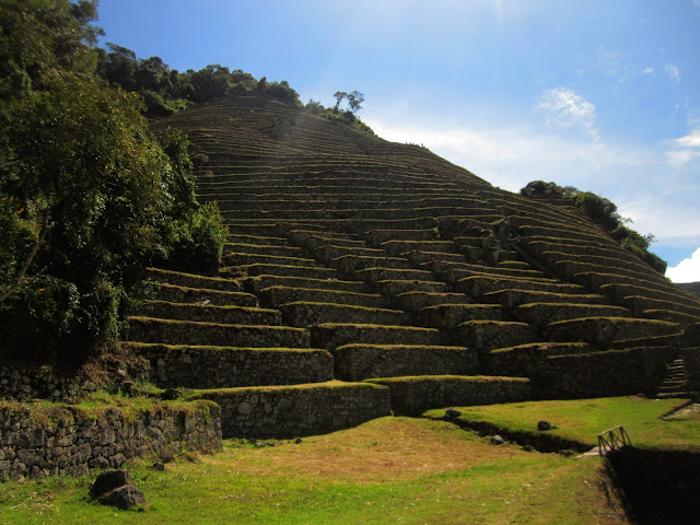
What do I see?  Another Inca site called Intipata. Yes, it is downhill.  Every single step on this trek is a life lesson.  After 2,400 feet downhill, my thighs are quivering.  Intipata is on a side trail, but after seeing it intricately carved into the mountainside, there is no question whether we want to make the diversion. 


Intipata means “Sunny Slope” or “The Place of the Sun.”  It consists of nearly 50 terraces and a few residential buildings.  The absence of plazas or gathering spaces, religious structures or fortifications leads to the conclusion that this was primarily an agricultural settlement, but because of its strategic position on the mountain mid-way between the Urabamba River and Machu Picchu and its panoramic view into the valley, it also could have served as a signaling site.  It is astounding to think that all of these places languished for hundreds of years and were only discovered within the last century. 

We walk along one of the terraces to where the curve widens.  Dropping our packs, we sit down and relax as Washington gives us background on the site.  The sun is shining, the air is a perfect temperature, and the view is surreal.  

I feel weightless as I lay down by the edge and look out across mountains that cannot be contained.
The Urabamba River is at my feet.

Washington patiently accepts each of our cameras and takes group photos for us. 

Another group shows up and their guide takes another round of photos with Washington included.

Terraces at Intipata

 Our campsite is only a couple of kilometers and 700 feet descent from Intipata.  It is called Wiñay Wayna.  The campsite once had a simple hostel but the building fell into disrepair and is no longer viable.  (I’m kind of glad because that means fewer people.)  Washington explains that late in the afternoon we have the opportunity to see the ancient Inca site of the same name.

Our tents are set up on a narrow terrace, barely room to walk from one to the next.  The baños are on a lower level, much too far to walk after dark with cramping thigh muscles.  We will find another solution for that. 

Lunch?  I can’t remember what is on the menu and I eat a minimal amount.  More important to me is siesta time.  Cathy and I enjoy our view.

The World Cup (soccer, y’all) kicks off this afternoon with the opening match between Brazil and Croatia.  What’s a fan to do up here in the Andes?  Miracle of miracles, an Inca Trail ranger’s house is nearby and he has a satellite connection.  For only one sol you can grab a space and cheer for…Brazil, of course.  Cathy, Andy, Sergi, Cami and Francine join the chaos, but I am lying on my sleeping bag and I cannot move a muscle.  Chris and Maria are comatose in their tents on either side of me.  I hear murmuring voices as I drift in and out and am so very grateful for these few hours of inertia.  I have not felt rested since I left home. 

Everyone returns from the soccer match and Washington gathers us together to visit Wiñay Wayna.  For a moment I consider staying behind to continue my beauty rest, but it is a 15-minute walk, and now I am catching on that the Inca sites are increasingly larger and more elaborate as we get closer to Machu Picchu.  I think we are about to see something grand.  Yes, yes, we are.

Wiñay Wayna means “Forever Young.”  It is the most intricate and awe-inspiring site we have seen on our trek.  The complex is divided into two sections, with a temple and houses at the top and more rustic structures below, and terraces between and extending out the sides.  The two sections are linked by a staircase and a set of ten ceremonial baths as the water descends down the terraces (the water flows from a spring that originates at Phuytupatamarka).   Several springs carry water to various stone baths located at different levels throughout Wiñay Wayna. 


Llamas are good at posing for photos.  They roam the Inca sites as part of the landscaping crew.

Washington is also a good poser as he stands next to llama poop.

The Urabamba River through a doorway at Wiñay Wayna.

In the late afternoon there are few people at Wiñay Wayna.  We feel a reverence here, talking in low voices, and in the peaceful quiet I can hear water from three different places:  the Urabamba River crashing below, a beautiful waterfall cascading nearby, and a tiny trickling stream from the cistern system.  As the light fades, we head back to camp. 

In the dining tent snacks await, more popcorn and “flat wontons” which look like fried tortilla strips.  The soup is a chicken and vegetable broth, a salad of tomatoes, lettuce and zucchini cut in thin strips, beef au jus, and stuffed peppers, which I avoid.  Apparently some of the peppers are hotter than others  because Sergi takes a bite and begins coughing and panting, “Agua! Agua!”  He takes a lot of teasing for not being able to handle the peppers. As a special treat, the cook presents us with a cake for good luck, and it is delicioso, vanilla flavored, dense, not too sweet.  We cut it in small pieces to share with the porters, too.

Speaking of porters, Washington explains that it is customary to tip the porters and our cook (we knew about this ahead of time) and he leaves us after dinner to put our heads together and pool our money.  Cami is very adept at converting dollars to soles and is adamant that we not overtip, explaining that being too generous sets an expectation that may not be met at other times.  Next we have a formal ceremony with the porters where we thank them for their service and present them with their gifts.  We will see them only briefly in the morning, as they must pack up camp and hike down a different trail than we are taking so that they can catch the 5:45 a.m. train leaving the town of Aguas Calientes. 

That means we must get up and leave camp by 4:00 a.m.  What???  Hard to get to sleep knowing that, plus the anticipation of reaching our destination tomorrow.  This journey has been difficult, exhausting, and stressful, but the rewards thus far have been worth the effort and beyond my expectations.  After all we have seen, what will Machu Picchu be like?

I have been wearing my favorite Liberty hat during the cool mornings and evenings of our trek and Nestor has expressed a liking for it.  Whenever he sees me he points to my hat and his and indicates an exchange: me and my friend with his big-hearted smile. 


Since there is nothing so well worth having as friends, never lose a chance to make them.”  ~Francesco Guicciardini


Thursday, September 18, 2014

Adventures in Peru - Dead Woman's Pass (This Is the Hard Part)


Adventures in Peru – 6/11/14 – Dead Woman’s Pass (This Is The Hard Part) – Wayllabamba to Chaquiqocha – 15 Km


“Buenos dias!”  Although technically it is not yet daytime, greetings waft gently into our tent and two cups of hot coca tea are placed by the door.  Do we want sugar?  Yes, please.  We also have hot water to wash our faces and hands. The night was chilly but my gear served me well.

At 5:30 a.m. we all assemble in our dining tent for breakfast:  fresh fruit, hot porridge, a thin type of pancake, dry crusty bread and marmalade, yogurt and cereal, more coca tea.  Carbing up for the big climb as the sky lightens up, revealing nervous faces.  Boiled water is offered to fill up our water containers for the day.  After handing off our extra items to the porters, we are all packed and stepping out by 6:40 a.m.  We will be hiking all day.

The trail ascends immediately up through the cloud forest, a new term to me.  A key difference between a cloud forest and a rainforest is elevation.  Rainforests are located at lower elevations and tend to be much warmer.  Cloud forests are usually located at higher elevations and are much cooler, although still quite humid. This difference in temperature contributes to the mist that is often visible in cloud forests, as the milder temperatures slow the evaporation process.  Topography also plays a role, as rainforests cover land with little elevation change while cloud forests are in mountainous regions with large differences in elevation from peaks to valleys.  We start at an elevation higher than 10,000 feet and walk in a cloud forest until we get above tree line altogether.  Later in the day we will descend into a rainforest.


There goes Maria.  As I mentioned earlier, our hiking order is established, with Cathy, Andy, Chris and Sergi vying for first place, then Maria on the uphills (she is very fast on downhills), myself, Cami and her mother Francine.  Cami starts out with her mom but spends the rest of the day skipping ahead like an 18-year-old and circling back to check on mom.  Did I ever have that kind of effortless energy?

Speaking of effort, the infamous Inca steps begin for real

Speaking of effort, Part 2, I notice several people carrying nothing but water bladders on their backs running past me early this morning, part of a Machu Picchu marathon.  Yikes.

Water flows rambunctiously down the mountain and lush growth is thick on the tree trunks.  I try to take photos of flowers but they don’t turn out well, perhaps because my hands are trembling from who knows what, altitude, medication, exhaustion?  There are exotic blooms everywhere, many small orchids.  This is fuschia.  


Occasionally other hikers pass me and I note critically that they are carrying small daypacks.  I am certain that my load is heavier than anyone else on the Inca Trail today.  Well…except for those porters.  Etiquette dictates staying on the mountain side of the trail so porters can pass on the outside.  Can you see the tiny red team porters and yellow porters in the photo?


I walk alone most of the morning, carrying my thoughts which vary from positive to negative and back again.  There is more tingling in my fingers and I know I should have eaten more breakfast.  The physical work is very intense and there is just no way to go faster and maintain a good breathing pattern.  Tedious, suffocating, inching progress.  I realize my mistake in carrying water bottles because I cannot reach them in my side pockets without removing my pack.  I learn to ask for a hand occasionally when someone passes me.  We are all walking in the same direction and people are very congenial and supportive.  In spite of the physical challenge, I am able to appreciate that the weather is spectacular.  The Andes are majestic. 


After the first 1.5 hours I round the mountain and enter the puna, the treeless grassland of the high Andes.  Time to take off long sleeves, apply sunscreen and get into the zone for more hard work plus sweating.  Washington, who has been trailing behind Francine, works his way up to me and casually starts a conversation.  As we walk slowly, he talks about the flowers we are seeing and more history of the area, asks me questions about where I live.  I realize that, rather than simply asking me how I’m doing, he is assessing my breathing and my pace as we talk.  I am appreciative that he is not the loud cheerleader type (by now I’ve seen/heard a couple of these guides on the trail).  He tells me that I am doing well, have plenty of time, and that we will all meet together at Dead Woman’s Pass.

Do you believe that the universe sends you a boost when you really need it?  Well…a young woman in a Virginia Tech tee shirt passed me (not the same group we met in Cusco earlier) and saw my VT ball cap.  We shouted and cheered and promised to get a photo together at the top.  My pace didn’t change but my attitude lifted. 

Tiny people at the pass

After six hours and a 3,600-foot ascent I reach Warmiwanuska, Dead Woman’s Pass, the highest point of our trek at 13,900 feet.  The air is full of celebration and cheers from each team as its members straggle up.  Washington gathers the Spanglish team together in a circle, we thank the mountain for the safe journey, and he reaches behind his feet into a clump of grass and pulls out…a bottle of champagne!  From his pack he produces nine little tin drinking cups.  As the cork pops, other groups look at us with envy, and we are known thereafter as the champagne group.  Group photos, individual photos, scenery photos, toasts and smiles all around.  And don’t forget to place the stone you carried up the mountain onto the cairn!
The Champagne Spanglish Team at Dead Woman’s Pass, Inca Trail, Peru – suitable for framing

Cheers!

Me and my new Hokie friend Star, a 2004 VT graduate, at Dead Woman’s Pass

Six hours of hiking, another four to go, and we haven’t had lunch yet.  Some of the group has been at the pass for over an hour and it’s cold.  I’m afraid Francine didn’t get much of a rest.  Now it’s time to lose most of the elevation we’ve gained.  The infamous Inca steps are even more intimidating to descend.  They are unevenly steep but I try to adopt a one-step two-step, occasionally alternating legs, to be as gentle as possible on my knees, and I turn slightly to the side rather than stepping straight down.  For the most part this seems to work and I don’t develop the agonizing IT band pain I have worried about.  I am better able to keep up with the group going down.  Andy shares the same knee concerns and we commiserate.  Washington wisely observes, “Uphill, the mind hurts.  Downhill, the body hurts.”

I am missing any photos of the magnificent landscape during this section, concentrating so fiercely on my steps.  After a 2,500-foot descent we arrive at Pacaymayo at 11,480 feet elevation, our lunch stop.  This is where some groups spend the night, but we are pressing on. 

Washington and Nestor taking a rest in the dining tent before lunch

What’s on the menu?  Fermented potato soup (remember to spill a spoonful on the ground), pumpkin empanadas, chicken sausage rollups, salad with vinaigrette dressing, quinoa, mashed potatoes and coca tea.  Cathy urges me again to eat more, and I don’t finish the soup so that I have room for a few bites.  The empanadas are delicious.  I mention to Washington that my hands are still tingling and the sensation has migrated up to my elbows.  He tells me to stop taking the Diamox, since we are now past our highest elevation.

Vamos!  Our second climb of the day is waiting.  It is hard to get our heads back into the groove.  Haven’t we done the impossible already, conquering Dead Woman’s Pass?  We are assured that we will be glad tomorrow that we are working so hard today.  (True statement.) 

An orchid:  Washington called these “dancing ladies”

Lupines

Part way up the second climb we visit the ruins of Runkurakay, an Inca tambo or resting place where travelers would stop over for food and rest for a while until they could continue their trip onward to or from Machu Picchu.  The site is small but unusual for its round shape and it commands an imposing view overlooking the Pacamayo Valley.  


We continue climbing up to Runkurakay Pass, passing two small lagoons.  When I arrive, of course, most of our group is ahead of me and scampering on the rocks off-trail to the tippy-top for the ultimate view.  I am happy to just rest at 12,960 feet.  
Guess what?  Downhill we go.  We have one more Inca site to check out and we want to get to camp before dark. 

When I arrive at the steps up to the site of Sayaqmarka, Washington takes one look at me and tells me I have the option to walk around it and meet them on the other side.  However, Maria tells me in her beautifully accented English that it is not hard at all to walk up the steep steps.  Maria is lying…but I forgive her because I am very glad I did not skip this opportunity.

Sayaqmarka means “inaccessible town” or “dominant town” depending on what you read.  It is breathtaking.  It sits on the tip of a very prominent ridge, protected on three sides by sheer cliffs, and it can only be accessed from the fourth side by the steep 98 steps hugging the edge of the mountain.


Archeologists and historians are not sure of the purpose of Sayaqmarka (as with all Inca archeological sites, there are no written records so best guesses vary).  Perhaps it served as another rest stop along the way to Machu Picchu, but it is very different from Runkurakay.  It is an elaborate site in a strategic and inaccessible location with no place to cultivate crops (however, Intipata is not far away, a massive site for crop cultivation).  Sayaqmarka consists of two parts, a solar observation post called the Temple of the Sun (the Incas were very big on astronomy) and a residential section with a sophisticated canal system for collecting water and filling ceremonial baths.  Was this a retreat for religious purposes?  Fascinating stuff.  Note:  you can only see these sites by hiking the original Inca Trail.


Fascinating, but the sun is winding down and we are all running out of energy.  Vamos!  We soon arrive at our camp for the night, Chaquiqocha, still at 12,000 feet elevation.  How grateful are we for our porters who carry our stuff, put up our tents, blow up our sleeping mats and prepare our food?  Grateful beyond words.  

Hot chocolate and popcorn are waiting for us and we eat greedily as though it may be taken away.  (More appears when the bowl is empty.)  Supper includes a wheat/noodle/vegetable soup, beef and vegetables au jus with white rice, cooked vegetables with sausage, shoestring type French fries, purple corn consommé with flour.  More hot chocolate, please.  We linger a long while in the dining tent, talking over the awesomeness of the day. 

As Cathy and I crawl into our tent for the second night of our adventure, I feel slightly less stressed.  The big challenge is behind me.  Home is far away and I loosen my grip on whatever is happening there.  Along with the altitude meds, I’ve given up on taking my antibiotics, for good or ill.  Life feels a little simpler up here closer to God.

“It’s not the mountain we conquer, but ourselves.”  ~Sir Edmund Hillary


“He who climbs upon the highest mountains laughs at all tragedies, real or imaginary.”  ~Friedrich Neitszche