
Solo Backpack in the Smokies – 4-11-12 – Mingus Creek
Trail/Newton Bald Trail/Thomas Divide Trail/Deeplow Gap Trail – 13.7 Miles
Beginning with my 50th I’ve spent every birthday
on a trail for a significant project, the Smokies 900 or the Mountains-to-SeaTrail. What about this year? It’s a Wednesday, so it would be a solo hike,
but the SB6K project didn’t seem to click.
What about…a solo backpack trip?
Now that’s a phrase I never thought would apply to me. Certainly a new threshold, a new line to
cross. I’ve hiked alone all day, slept
in frontcountry campgrounds alone all night, but never spent the night alone in
the deep dark woods.
What better place to try this new challenge than the Great
Smoky Mountains? I’ve been meaning to
hike those trails again anyway. Poring
over the map looking for possible overnight loop hikes, I got that tingly
feeling that I love. I chose a
figure-eight type route and a backcountry campsite that should be empty on a
weeknight. I left a very detailed hike
plan with my husband and left home very early on Wednesday morning.
The weather had been warmer than normal for a couple of
weeks but a cold front was coming through, predicting nighttime temps in the
high 20’s. The drive through the mountains
was very windy and I had a few thoughts about branches and trees falling on
tents. The Blue Ridge Parkway was closed
near the entrance to the Smokies so I had to drive through the town of Cherokee,
normally something I don’t mind but I wasn’t in the mood for it today. I wanted to get on the trail. I stopped at the Occonaluftee Visitor Center
and self-registered for my campsite. As
I stuffed my form into the box I wondered just how often they check those
things.
I parked at the Mingus Mill parking lot and made a last
minute check of my gear – anything I can leave out or should add in? My trail map split apart as I consulted it
one more time. Oh, well, I’ll have to rely
on piecing it together. A good thing I
had studied it so much beforehand.

Before I started on the trail I visited the slave cemetery a short walk from the far corner of the parking lot. There are six graves evidenced by rough uncarved sandstones.

Oops, forgot my new hiking poles – gotta go back.

Beginning of my adventure – Mingus Mill in the background
Mingus Creek Trail begins as a wide road bed. Along the first mile there are remnants of
many buildings from old homesteads and the CCC camp that operated there. Flowers bloomed profusely along the path.

Some type of phlox

White erect trillium (distinguished by its dark center)
At 1.25 miles the trail split. Mingus Creek Trail continued to the
left. The unnamed trail to the right
leads .8 miles to another cemetery. One
of my interests in re-hiking the Smokies is to take more time investigating the
cemeteries. Some are harder to find than
others. I had planned to visit this
particular one on my return hike the next day, but something told me to go sooner
rather than later…so I did.


Mingus Creek Cemetery seemed a bit forlorn, no flowers on
any graves

Mrs. Polly Mathis, born 1888, died 1934
I backtracked to Mingus Creek Trail and began the long
climb. In the first few minutes I met
four descending hikers, the only people I saw before returning to the parking
lot the next afternoon. Now it was just
me, myself and I.

Toothwort

Showy orchis
The Mingus Creek Trail actually leaves Mingus Creek very
early on and instead follows Madcap Branch up the mountainside, crossing
several times (fun name, “Madcap”). At
about the three-mile mark the trail intersects with Deeplow Gap Trail, which I
will return to this spot tomorrow. After
a brief quarter-mile respite of near level walking, Mingus Creek Trail resumes
its climb – a total of six miles and 3,000 feet of ascent from the
beginning. But going slow and steady,
not trying to keep up with anyone, it felt great.
At 5,080 feet Mingus Creek Trail meets Newton Bald
Trail. While some balds in the Smokies
are managed by the Park service to remain open, Newton is Bald no more, just
another wooded mountain top. There is a
big old chestnut tree trunk to rest on while you ponder life, though.
A bear condo on Newton Bald Trail (see the hole near the top?) Dead trees that are still standing are called snags and are a very important part of a healthy forest ecosystem, providing home for creatures great and small. Don’t stick your head in one of these holes.
A bear condo on Newton Bald Trail (see the hole near the top?) Dead trees that are still standing are called snags and are a very important part of a healthy forest ecosystem, providing home for creatures great and small. Don’t stick your head in one of these holes.

I continued on for .7 miles along Newton Bald Trail, passing
through Campsite #52 sprawled across the trail.
It looks like a great place to camp in good weather, but I wouldn’t want
to be huddled there in my tent on that ridge during a bad nighttime
thunderstorm. At the intersection with
Thomas Divide Trail I turned left, very much looking forward to some
downhill. The walk down Thomas Divide
was just lovely with glimpses of the high ridgeline of the AT to the
right. (If I’d had my glasses I could
have really seen the Clingmans Dome tower.)
A nice breeze was blowing on the western side of Thomas Divide, while on
the eastern side I was more protected.
It was a day for short sleeves and gloves. As I strolled merrily along I hummed and sang
“Agnus Dei”. Alleluias sound so awesome
in the outdoors!
At one point on Thomas Divide, as the trail rounded the side
of a mountain and curved onto the next one, I noticed that the first part was
completely brown, still in winter mode, while the opposite facing side was
covered in mayapple foliage. Imagine a
giant letter “V” lying on the ground with one side brown and one side
green. Neat, huh?

After 3.1 miles on Thomas Divide I turned right onto Deeplow
Gap Trail, still continuing downhill.
Deeplow Gap Trail has multiple personalities: easy and clear, rocky and
covered with debris, and muddy and rutted from horse travel. Big fun.
It also had a stunning display of crested dwarf iris.


Squaw root – a bear’s favorite spring snack

Rue anemone
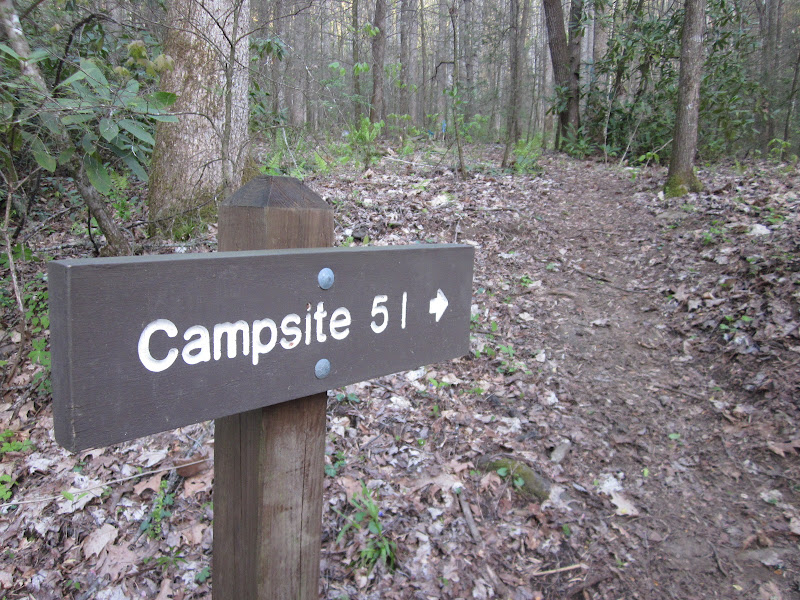
As I mentally counted up the miles for the day I began to
get a little anxious to find my campsite for the night. Usually the campsites are well marked but I
have walked past a few, so I became intent on scanning the sides of the trail
for signs. And…this one is pretty
obvious.
So I was at camp by 6:00 p.m., plenty of time to drop my
pack and make a quick .8-mile roundtrip to the end of Deeplow Gap where it
meets Indian Creek Trail. Remember, if
you are going to hike all of the Smokies 900 trails, pay attention to those
loose ends.

At my campsite, work to be done: collect and treat water, boil some for
dinner, add to dehydrated meal packet, make some hot tea.
While all that is rehydrating and steeping, set up
tent. Campsite 51 only had two small
tent sites that I could find, so I choose the one farthest from the trail. (The best thing about Smokies backcountry
sites: cable pulley systems to hang your
food away from the critters.)

Unfortunately, my meal was pretty terrible, too spicy for
me, burning my lips that were already tenderized from the windy day. But…I ate it all because I didn’t want to
carry it out the next day. I opted not
to make the chocolate pudding mix that I brought, didn’t think I could eat it
all, but I had M&M’s to enjoy.
After dinner, I read my little book in the surprisingly gradual fading of the light. The wind had died down and a chill descended. By 8:00 p.m. I retired to my tent to get warm and settled in. By 8:45 p.m. it was lights out, sister. Hope I hear some hooty-owls tonight.
After dinner, I read my little book in the surprisingly gradual fading of the light. The wind had died down and a chill descended. By 8:00 p.m. I retired to my tent to get warm and settled in. By 8:45 p.m. it was lights out, sister. Hope I hear some hooty-owls tonight.

Birthdays are good for you. Statistics show that the
people who have the most live the longest. ~Larry Lorenzoni


