
Friday, July 24, 2009
Heading West
Leaving early tomorrow morning on our trip to the Grand Tetons. Trail reports show that we will be hiking in snow! Why am I so nervous? Maybe because Jeff is sending me YouTube videos of how to self-arrest with an ice axe...
Thursday, July 23, 2009
Thumbs Up - Thumbs Out
Pisgah Backpack – Day Two – MST/Ivestor Gap Trail/Fork Mountain Trail - 13 miles
Cheerful bird chirping woke me very early and my tent began to lighten with the sunrise. When the walls began to turn pink, I realized I might get to see something special outside, so I unzipped and poked my head out into the very dewy wet morning. The sky was a pretty pink and it was time to get cracking for another fun day on the trail.
Jeff says the temperature got down to the high 40’s and it was definitely chilly as we ate breakfast. We packed up and headed out by 8:00 a.m., looking at 13 miles to get us back to our starting point. The good news was that the route was not as steep as yesterday. The bad news was it was 13 miles. We filled up with water at a new spot and then crossed Highway 215. Remember, we were now following the Mountains-to-Sea Trail (MST), which is blazed with a white circle (which helped my comfort level) and we were paralleling the Blue Ridge Parkway. Soon we reached the trail intersection where a left went to Little Sam Knob and a right went over the Parkway and up to the Devil’s Courthouse Overlook. Jeff and Ken went to check out the view, while Laurie and I chilled and chatted and looked at maps. She seemed a little less stressed than yesterday and I tried to keep up a joking conversation, but I knew I was more fatigued after yesterday’s challenges and that I needed to conserve my energy. So moderate to slow hiking was the name of the game for me, and the terrain was gentle ups and downs…all good.
So I was very surprised when Laurie told me that at our next road crossing she wanted to bail out. She wondered if there would be cell reception to call a taxi, and I explained that cell phone reception was unreliable but that since that road was really just access to parking for hikers, and it was a beautiful Sunday, that we could probably find her a ride back to her car if that is what she wanted to do. Laurie said that she was tired, that going another 7 miles would make her so tired that she worried about driving alone back to Charlotte, and that she would not be able to go to work the following morning.
Now, some people would say to just suck it up, but I give Laurie big thumbs up for assessing her situation and making a safe decision. If she had been unable to continue at some point, the rest of us would have had to help carry her and her gear out (and I was working hard to handle just my own self). If she had continued safely but been miserable, what’s the point in that? Backpacking is not a contest. So at Black Balsam Road we stuck out our thumbs and within ten minutes Laurie was on her way back to her car – and Jeff and Ken and I turned onto the Ivestor Gap Trail.
I was familiar with Ivestor Gap from the Cold Mountain hike. It’s an old road bed without shade and we warmed up quite a bit. After a mile or so we turned left and Jeff led us onto the Fork Mountain Trail, where no one has walked except Jeff in the last year, I’m sure. There was undergrowth, overgrowth and everywhere growth. Fork Mountain Trail is about six miles long and seems…longer. It was surprisingly level. At one point we passed through a large bald area (good campsite) and Jeff and Ken went off to locate a spring that Jeff had heard about while I kept watch over the area from underneath a nice shady tree.
Not many details of this part of the hike and not many photos – you’ll have to go see for yourself. The guys went slowly and casually to make me feel like I was keeping up with them. Even the small ups seemed steep and I had to admit once again that I am not a great backpacker, carrying the extra weight. There was a little bit of rock scrambling and a couple of times I lost the trail, but they were not too far ahead to talk me through it. Like Green Mountain, the trail is just very faint.
Fork Mountain Trail finally took a very sharp left and the descent began in earnest (remember the 3,000-foot gain yesterday morning?) While armchair hikers may think that down is better than up – think again. You can catch your breath but you can’t save those knees. There were 12 very long switchbacks (yes, I counted) in the 2-mile downhill and we were each in our own world on that downhill (…tell me again why I do this…tell me again why I do this…tell me again…). And our reward? At the bottom we had to cross that West Fork of the Pigeon River, knee deep and refreshing!
In soaking wet boots we sloshed our way past the popular swimming hole full of teenagers jumping off bridges (hey, y’all, watch this!) and to the parking area, a half-mile that I had not been counting in my head as part of our mileage for the day. I was very thankful that Laurie had not continued because she would have hated it – I was hoping that memory would soften the experience for myself. And as usually happens, looking back, the pain goes away and the feeling of accomplishment grows.
Thus I completed a backpacking trip in the Pisgah National Forest. Have you heard of a challenge called the Pisgah 400?
P.S. The next day Laurie decided to drop out of the Grand Tetons trip…
Truly it may be said that the outside of a mountain is good for the inside of a man. ~George Wherry, Alpine Notes and the Climbing Foot, 1896
Cheerful bird chirping woke me
 very early and my tent began to lighten with the sunrise. When the walls began to turn pink, I realized I might get to see something special outside, so I unzipped and poked my head out into the very dewy wet morning. The sky was a pretty pink and it was time to get cracking for another fun day on the trail.
Jeff says the temperature got down to the high 40’s and it was definitely chilly as we ate breakfast. We packed up and headed out by 8:00 a.m., looking at 13 miles to get us back to our starting point. The good news was that the route was not as steep as yesterday. The bad news was it was 13 miles. We filled up with water at a new spot and then crossed Highway 215.
 Remember, we were now following the Mountains-to-Sea Trail (MST), which is blazed with a white circle (which helped my comfort level) and we were paralleling the Blue Ridge Parkway. Soon we reached the trail intersection where a left went to Little Sam Knob and a right went over the Parkway and up to the Devil’s Courthouse Overlook. Jeff and Ken went to check out the view, while Laurie and I chilled and chatted and looked at maps. She seemed a little less stressed than yesterday and I tried to keep up a joking conversation, but I knew I was more fatigued after yesterday’s challenges and that I needed to conserve my energy. So moderate to slow hiking was the name of the game for me, and the terrain was gentle ups and downs…all good.
So I was very surprised when Laurie told me that at our next road crossing she wanted to bail out. She wondered if there would be cell reception to call a taxi, and I explained that cell phone reception was unreliable but that since that road was really just access to parking for hikers, and it was a beautiful Sunday, that we could probably find her a ride back to her car if that is what she wanted to do. Laurie said that she was tired, that going another 7 miles would make her so tired that she worried about driving alone back to Charlotte, and that she would not be able to go to work the following morning.
Now, some people would say to just suck it up, but I give Laurie big thumbs up for assessing her situation and making a safe decision. If she had been unable to continue at some point, the rest of us would have had to help carry her and her gear out (and I was working hard to handle just my own self). If she had continued safely
 but been miserable, what’s the point in that? Backpacking is not a contest. So at Black Balsam Road we stuck out our thumbs and within ten minutes Laurie was on her way back to her car – and Jeff and Ken and I turned onto the Ivestor Gap Trail.
I was familiar with Ivestor Gap from the Cold Mountain hike. It’s an old road bed without shade and we warmed up quite a bit. After a mile or so we turned left and Jeff led us onto the Fork Mountain Trail, where no one has walked except Jeff in the last year, I’m sure. There was undergrowth, overgrowth and everywhere growth. Fork Mountain Trail is about six miles long and seems…longer. It was surprisingly level. At one point we passed through a large bald area (good campsite) and Jeff and Ken went off to locate a spring that Jeff had heard about while I kept watch over the area from underneath a nice shady tree.
Not many details of this part of the hike and not many photos – you’ll have to go see for yourself. The guys went slowly and casually to make me feel like I was keeping up with them. Even the small ups seemed steep and I had to admit once again that I am not a great backpacker, carrying the extra weight. There was a little bit of rock scrambling and a couple of times I lost the trail, but they were not too far ahead to talk me through it. Like Green Mountain, the trail is just very faint.
Fork Mountain Trail finally took a very sharp left and the descent began in earnest (remember the 3,000-foot gain yesterday morning?) While armchair hikers may think that down is better than up – think again. You can catch your breath but you can’t save those knees. There were 12 very long switchbacks (yes, I counted) in the 2-mile downhill and we were each in our own world on that downhill (…tell me again why I do this…tell me again why I do this…tell me again…). And our reward? At the bottom we had to cross that West Fork of the Pigeon River, knee deep and refreshing!
In soaking wet boots we sloshed our way past the popular swimming hole full of teenagers jumping off bridges (hey, y’all, watch this!) and to the parking area, a half-mile that I had not been counting in my head as part of our mileage for the day. I was very thankful that Laurie had not continued because she would have hated it – I was hoping that memory would soften the experience for myself. And as usually happens, looking back, the pain goes away and the feeling of accomplishment grows.

Thus I completed a backpacking trip in the Pisgah National Forest. Have you heard of a challenge called the Pisgah 400?
P.S. The next day Laurie decided to drop out of the Grand Tetons trip…
Truly it may be said that the outside of a mountain is good for the inside of a man. ~George Wherry, Alpine Notes and the Climbing Foot, 1896
Monday, July 20, 2009
A Van Gogh Experience
June 27-28, 2009 – Overnight Backpack in Pisgah National Forest – 21.3 Miles
In late July I am heading to the Grand Tetons for a week of dayhiking and backpacking. My cohorts will be my friend Jeff, hiking guru, my friend Mike, who shepherded me through my first overnight backpack in the Smokies last fall, and a woman named Laurie, a Bergs member whom I have not hiked with before. This trip is really Jeff’s idea and we are just benefitting from all of his research and planning. The four of us have met once for dinner to discuss generalities and flights. We thought a shakedown hike would be a good idea, and finally settled on a date that 3 out of 4 of us could make it (Mike is always busy with some trip or another – I think he was on a biking trip this particular weekend.) Jeff proposed a loop in Pisgah that worked its way through Middle Prong Wilderness and Shining Rock Wilderness that he described as…well, here is his entire description:
“Rating: strenuous. It's a 21.3 mile loop with 5,400' elevation gain in Pisgah NF. The first 3.5 miles contains 3,000' of that elevation gain and there will be spots within that 3.5 miles that are extremely steep. Other than that, the rest of the route is somewhat flat. We will start at Sunburst Campground and hike start on the Green Mountain Trail and either camp off that trail at mile 5.5 or continue on the MST and camp at mile 8.0. The 2nd day we will continue on the MST to Black Balsam Rd and then pick up the Ivestor Gap trail. From there we'll head back to Sunburst via the Fork Mountain Trail. Water should be available close by the campsites and at several other locations along the route.”
In hindsight, warning signs were everywhere…
Jeff posted the overnight trip on the Bergs website and an unsuspecting new fellow named Ken signed up. Jeff quizzed him for his experience and, upon learning that Ken was a former Marine, said he could pretty much handle it. Another sign…you need to be a Marine to do handle this hike…
Bright and early Saturday morning I headed to the mountains, picked up Jeff along the way, met Ken at a prearranged spot, and then met up with Laurie at the trail parking area, a very popular summer spot for locals along the West Fork of the Pigeon River. We stepped off the road and onto the most vertical trail I have ever encountered in my admittedly short hiking life – the Green Mountain Trail. The first quarter-mile gained around 400 feet in elevation. (Pause for gasps from the audience.) We started off cracking jokes but soon switched to spitting curses. My hiking poles were useless as I grabbed for trees and roots and rocks. Laurie was a less experienced hiker and stopped often to adjust her pack, get food, or just plain rest – and I was grateful every time. Normally I would have pushed on and been miserable, but our slow pace and frequent breaks ultimately are what saved us all. As advertised, the first 3.5 miles were very steep and the trail makers missed switchback class. Also, the trail was faint (what, it’s not trampled by dozens of hikers every day?) and whenever I was leading I often had to ask, “Am I still on the trail?” This was the third time Jeff had hiked this route in about 3 month s (yes, he is certifiably insane) so he knew it intimately and told us in great detail what was coming up around the next bend, over the next rise, around the next boulder. It was not always welcome news.
BUT there are some awesome viewpoints along Green Mountain Trail. The trail eventually leveled out and we rediscovered norma l breathing as we crossed over Green Knob. From one vantage point Jeff named the mountains we were looking at, including my favorite, Sam Knob with its double peak (see photo). Our entire route circled these mountains and we saw them from every side. Most of the time I could pick out Sam Knob. We had agreed before starting that we would push to the campsite at Mile 8 ra
 ther than stay at Mile 5.5, but we checked that one out anyway. It was part of another fantastic bald area. Here are Ken and Laurie frolicking in the field. As tempting as it was to park here, we knew we could not handle a 16-mile hike the next day – actually, 13 miles was sounding pretty overwhelming. Onward! We completed our beloved Green Mountain Trail and turned left onto the Mountains-to-Sea Trail, skirting Mount Hardy (hey, that’s an SB6K, but there ain’t no way I’m climbing ‘er today.)
Over smaller mountains, inside rhodo tunnels, across open fields, the need for water was getting critical. With the heat of the day and the extreme uphill, my buddies ran out of water before we reached the first decent source – and they had carried a lot of water. I was getting close to empty as well. We tanked up and resumed marching. I don’t remember many details of this part, just waiting for Jeff to say, “This is it!”
And finally we walked into a big open field and set up camp. We were actually within a half-mile of Route 215. It had taken us 7 hours to walk 8 miles. Now it was approaching 8:00 p.m. and we had to work fast to cook, eat, clean up and hang food bags. Since I was treating water with my AquaMira drops and pouring it into my CamelBack, I wanted to get another bottle of water, so Jeff took me to another water source…just a drizzle coming out of the steep bank beside the trail, but it was water. It was so slow that I nearly nodded off waiting for the bottle to fill! Note: If you ever go on this route, fill up at the stream, don’t wait until you get to this campsite.
We cooked and ate supper close to the tree we had designated to hang our food, and as we ate we noticed that the dew was forming rapidly. A chill descended and I was glad I had packed that long sleeved shirt at the last moment. Jeff, ever the minimalist, had brought only the clothes on his back, which by now were getting damp. After housekeeping, we all crawled into tents to enjoy our night in the wilderness. And what a night it was! Not a single sound, no crickets, no owls, just total silence. Around 3:00 a.m. I ventured out for the inevitable potty break and was stunned by the stars. The moon had passed on and the stars were gleaming thickly in the ink-black sky. I don’t believe I have ever seen stars as clearly. There was no light source for many miles, no tree branches to peer through, no clouds. I bent my head waaaay back and said a prayer of thanks. Hiking up that ridiculous Green Mountain Trail was absolutely worth it to experience that night sky.
In late July I am heading to the Grand Tetons for a week of dayhiking and backpacking. My cohorts will be my friend Jeff, hiking guru, my friend Mike, who shepherded me through my first overnight backpack in the Smokies last fall, and a woman named Laurie, a Bergs member whom I have not hiked with before. This trip is really Jeff’s idea and we are just benefitting from all of his research and planning. The four of us have met once for dinner to discuss generalities and flights. We thought a shakedown hike would be a good idea, and finally settled on a date that 3 out of 4 of us could make it (Mike is always busy with some trip or another – I think he was on a biking trip this particular weekend.) Jeff proposed a loop in Pisgah that worked its way through Middle Prong Wilderness and Shining Rock Wilderness that he described as…well, here is his entire description:
“Rating: strenuous. It's a 21.3 mile loop with 5,400' elevation gain in Pisgah NF. The first 3.5 miles contains 3,000' of that elevation gain and there will be spots within that 3.5 miles that are extremely steep. Other than that, the rest of the route is somewhat flat. We will start at Sunburst Campground and hike start on the Green Mountain Trail and either camp off that trail at mile 5.5 or continue on the MST and camp at mile 8.0. The 2nd day we will continue on the MST to Black Balsam Rd and then pick up the Ivestor Gap trail. From there we'll head back to Sunburst via the Fork Mountain Trail. Water should be available close by the campsites and at several other locations along the route.”
In hindsight, warning signs were everywhere…
Jeff posted the overnight trip on the Bergs website and an unsuspecting new fellow named Ken signed up. Jeff quizzed him for his experience and, upon learning that Ken was a former Marine, said he could pretty much handle it. Another sign…you need to be a Marine to do handle this hike…

Bright and early Saturday morning I headed to the mountains, picked up Jeff along the way, met Ken at a prearranged spot, and then met up with Laurie at the trail parking area, a very popular summer spot for locals along the West Fork of the Pigeon River. We stepped off the road and onto the most vertical trail I have ever encountered in my admittedly short hiking life – the Green Mountain Trail. The first quarter-mile gained around 400 feet in elevation. (Pause for gasps from the audience.) We started off cracking jokes but soon switched to spitting curses. My hiking poles were useless as I grabbed for trees and roots and rocks. Laurie was a less experienced hiker and stopped often to adjust her pack, get food, or just plain rest – and I was grateful every time. Normally I would have pushed on and been miserable, but our slow pace and frequent breaks ultimately are what saved us all. As advertised, the first 3.5 miles were very steep and the trail makers missed switchback class. Also, the trail was faint (what, it’s not trampled by dozens of hikers every day?) and whenever I was leading I often had to ask, “Am I still on the trail?” This was the third time Jeff had hiked this route in about 3 month
 s (yes, he is certifiably insane) so he knew it intimately and told us in great detail what was coming up around the next bend, over the next rise, around the next boulder. It was not always welcome news.
BUT there are some awesome viewpoints along Green Mountain Trail. The trail eventually leveled out and we rediscovered norma
 l breathing as we crossed over Green Knob. From one vantage point Jeff named the mountains we were looking at, including my favorite, Sam Knob with its double peak (see photo). Our entire route circled these mountains and we saw them from every side. Most of the time I could pick out Sam Knob. We had agreed before starting that we would push to the campsite at Mile 8 ra
 ther than stay at Mile 5.5, but we checked that one out anyway. It was part of another fantastic bald area. Here are Ken and Laurie frolicking in the field. As tempting as it was to park here, we knew we could not handle a 16-mile hike the next day – actually, 13 miles was sounding pretty overwhelming. Onward! We completed our beloved Green Mountain Trail and turned left onto the Mountains-to-Sea Trail, skirting Mount Hardy (hey, that’s an SB6K, but there ain’t no way I’m climbing ‘er today.)
Over smaller mountains, inside rhodo tunnels, across open fields, the need for water was getting critical. With the heat of the day and the extreme uphill, my buddies ran out of water before
 we reached the first decent source – and they had carried a lot of water. I was getting close to empty as well. We tanked up and resumed marching. I don’t remember many details of this part, just waiting for Jeff to say, “This is it!”
And finally we walked into a big open field and set up camp. We were actually within
 a half-mile of Route 215. It had taken us 7 hours to walk 8 miles. Now it was approaching 8:00 p.m. and we had to work fast to cook, eat, clean up and hang food bags. Since I was treating water with my AquaMira drops and pouring it into my CamelBack, I wanted to get another bottle of water, so Jeff took me to another water source…just a drizzle coming out of the steep bank beside the trail, but it was water. It was so slow that I nearly nodded off waiting for the bottle to fill! Note: If you ever go on this route, fill up at the stream, don’t wait until you get to this campsite.
We cooked and ate supper close to the tree we had designated to hang our food, and as we ate we noticed that the dew was forming rapidly. A chill descended and I was glad I had packed that long sleeved shirt at the last moment. Jeff, ever the minimalist, had brought only the clothes on his back, which by now were getting damp. After housekeeping, we all crawled into tents to enjoy our night in the wilderness. And what a night it was! Not a single sound, no crickets, no owls, just total silence. Around 3:00 a.m. I ventured out for the inevitable potty break and was stunned by the stars. The moon had passed on and the stars were gleaming thickly in the ink-black sky. I don’t believe I have ever seen stars as clearly. There was no light source for many miles, no tree branches to peer through, no clouds. I bent my head waaaay back and said a prayer of thanks. Hiking up that ridiculous Green Mountain Trail was absolutely worth it to experience that night sky.
[Click here for Blue Ridge Outdoors' recent article on "The Wildest Hikes You Never Heard of" and read the description for North Carolina's choice.]
God writes the gospel not in the Bible alone, but on trees and flowers and clouds and stars. ~Martin Luther
Thursday, July 16, 2009
Roan Mountain and More SB6K's
Roan Mountain – 6/7/09 – Appalachian Trail – 10 miles
This morning I woke thinking that another 24 hours of sleep would be great. BUT I was scheduled to hike with the Carolina Mountain Club, including Danny and Lenny, in the Roan Mountains. I was very much looking forward to seeing the Roans, but I sure didn’t want another fast hiking day.
Not to worry – I give two thumbs way up to the CMC group for a delightful day! The drive to the trailhead was long, but I was neither driver nor navigator so no effort on my part. The group assembled at the Carvers Gap parking are a was varied and included four who had not hiked with CMC before – myself, a woman from Shelby, and a father-and-young-adult-son team from the Midwest who were traveling on their way to the beach and wanted to do something in celebration of National Trails Day. (CMC's hikes are show-and-go, not sign-up in advance.) Our hike leader had everyone sign in and give an emergency contact number, then reviewed the hike plan. He went over the guidelines of a lead and a sweep and that they would wait at junctions for the group to reassemble as a whole. Pinch me! I was thrilled.
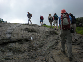
My husband and son had been to Roan Mountain back in their Boy Scout days but this was my first experience there. Yesterday’s hike in Shining Rock Wilderness gave me a taste of mountain balds and this hike was similar. The Roans are well-known for their rhododendrons but we were a little early for peak blooming ( mental note: third week of June is best). Today we headed north on the AT. The hiking pace was leisurely, not too slow, certainly not too fast, and we frequently stopped to identify anything blooming (someone was keeping count of how many different species could be found.) We went up and over Round Bald, down Engine Gap, and then over Jane Bald. The day was spectacular and I was having fun now!
We took a right turn up off of the AT to our first destination of the day, Grassy Ridge Bald, one of the SB6K peaks. As of today it is official – did any of you doubt it? – I am working on the SB6K Challenge. In the interest of my sanity I am not putting a time limit on this challenge, though. I am simply looking forward to exploring many different areas in the Southern Appalachians as I work toward this goal. And it will take me back to the Smokies! I summitted the SB6K’s that were directly on trails there, but some are off-trail and I passed them by.
Here is Lenny pointing out something of vital importance – not sure what! I have some great photos of Lenny.
From Grassy Ridge we backtracked a bit and chose a lunch spot. Some people sat together while others took the opportunity to sit alone and chill in a front row seat for this speci al place. This woman enjoyed her apple and then pulled out a book to read. I would have loved a nap, but it’s hard to appreciate the view with your eyes closed!
Our backtracking continued nearly all the way to the parking area, and we crossed the road to continue south on the AT, climbing steadily on switchbacks up to Roan High Knob, our second SB6K of the day. Here we explored the shelter, which at 6,285 feet is the highest shelt er on the entire AT. It is two stories and sleeps 16 friendly hikers. Here is a lovely photograph of the shelter in snow and further description. (BTW, this website, Appalachian Treks, is one of my favorites. He posts photos nearly every day with a short quote, story or Bible verse. A great way to start the day.)
The true summit of Roan High Knob is atop a rock outcropping a short distance from the shelter. This benchmark is embedded in the rock. Here’s a hint if you decide to become an SB6K enthusiast yourself: the placement o f the benchmark is not always the very highest point. Look around and see if there is anything higher than where you are standing (or check your GPS). Of course you are on the honor system anyway, but I’d hate for you to miss the summit by a few feet.
Most of the group planned to backtrack to the parking lot from this point, but Danny and Lenny had worked out a plan to continue on to summit the third SB6K at Roan High Bluff. Five of us pressed on and drivers from the return bunch offered to retrieve us and return us to our cars. (In the end, the returners hiked more mileage than we did!) Our route took us past the former location of the Cloudland Hotel, once a luxury hotel that straddled the NC-TN state line. Appalachian Treks has a humorous summary about the demarcation line. We followed the Cloudland Trail out to the Bluff Overlook, a wooden platform constructed to keep people from throwing themselves off the edge. There are several parking areas up near this end of the trail for easy access to the overlook, i.e., we were not alone. Adults, kids, dogs – everyon e was enjoying the day.
I most thoroughly enjoyed hiking with the CMC group. Staying together afforded the opportunity to talk with everyone and I learned some new flowers and the opportunity for more hikes, including a backpack trip that the group makes every year to do the more difficult off-trail SB6K’s in the Smokies – yay! This was just the hike I needed today.
Our trail angels delivered us back to our cars and we began the long drive to Asheville. We decided that sushi was called for, and we stopped at the Bernsteins’ home so I could retrieve my car.
Well, no day is perfect – my battery was dead and we had some fun resurrecting it. After a delicious meal and goodbyes, I popped in my favorite CD’s and went on auto-pilot to Charlotte, arriving late but happy. Two big goals in one weekend – Cold Mountain and Roan Mountain! And I’m still alive! My list of destinations is growing longer…
Congratulations! Today is your day. You're off to Great Places! You're off and away! You have brains in your head. You have feet in your shoes You can steer yourself any direction you choose. You're on your own. And you know what you know. And YOU are the guy who'll decide where to go... So...be your name Buxbaum or Bixby or Bray or Mordecai Ali Van Allen O'Shea, you're off to Great Places! Today is your day! Your mountain is waiting. So...get on your way! ~Dr. Suess "Oh, The Places You'll Go"
This morning I woke thinking that another 24 hours of sleep would be great. BUT I was scheduled to hike with the Carolina Mountain Club, including Danny and Lenny, in the Roan Mountains. I was very much looking forward to seeing the Roans, but I sure didn’t want another fast hiking day.
Not to worry – I give two thumbs way up to the CMC group for a delightful day! The drive to the trailhead was long, but I was neither driver nor navigator so no effort on my part. The group assembled at the Carvers Gap parking are
 a was varied and included four who had not hiked with CMC before – myself, a woman from Shelby, and a father-and-young-adult-son team from the Midwest who were traveling on their way to the beach and wanted to do something in celebration of National Trails Day. (CMC's hikes are show-and-go, not sign-up in advance.) Our hike leader had everyone sign in and give an emergency contact number, then reviewed the hike plan. He went over the guidelines of a lead and a sweep and that they would wait at junctions for the group to reassemble as a whole. Pinch me! I was thrilled.
My husband and son had been to Roan Mountain back in their Boy Scout days but this was my first experience there. Yesterday’s hike in Shining Rock Wilderness gave me a taste of mountain balds and this hike was similar. The Roans are well-known for their rhododendrons but we were a little early for peak blooming (
 mental note: third week of June is best). Today we headed north on the AT. The hiking pace was leisurely, not too slow, certainly not too fast, and we frequently stopped to identify anything blooming (someone was keeping count of how many different species could be found.) We went up and over Round Bald, down Engine Gap, and then over Jane Bald. The day was spectacular and I was having fun now!
We took a right turn up off of the AT to our first destination of the day, Grassy Ridge Bald, one of the SB6K peaks. As of today it is official – did any of you doubt it? – I am working on the SB6K Challenge. In the interest of my sanity I am not putting a time limit on this challenge, though. I am simply looking forward to exploring many different areas in the Southern Appalachians as I work toward this goal. And it will take me back to the Smokies! I summitted the SB6K’s that were directly on trails there, but some are off-trail and I passed them by.

Here is Lenny pointing out something of vital importance – not sure what! I have some great photos of Lenny.
From Grassy Ridge we backtracked a bit and chose a lunch spot. Some people sat together while others took the opportunity to sit alone and chill in a front row seat for this speci
 al place. This woman enjoyed her apple and then pulled out a book to read. I would have loved a nap, but it’s hard to appreciate the view with your eyes closed!
Our backtracking continued nearly all the way to the parking area, and we crossed the road to continue south on the AT, climbing steadily on switchbacks up to Roan High Knob, our second SB6K of the day. Here we explored the shelter, which at 6,285 feet is the highest shelt
 er on the entire AT. It is two stories and sleeps 16 friendly hikers. Here is a lovely photograph of the shelter in snow and further description. (BTW, this website, Appalachian Treks, is one of my favorites. He posts photos nearly every day with a short quote, story or Bible verse. A great way to start the day.)
The true summit of Roan High Knob is atop a rock outcropping a short distance from the shelter. This benchmark is embedded in the rock. Here’s a hint if you decide to become an SB6K enthusiast yourself: the placement o
 f the benchmark is not always the very highest point. Look around and see if there is anything higher than where you are standing (or check your GPS). Of course you are on the honor system anyway, but I’d hate for you to miss the summit by a few feet.
 Most of the group planned to backtrack to the parking lot from this point, but Danny and Lenny had worked out a plan to continue on to summit the third SB6K at Roan High Bluff. Five of us pressed on and drivers from the return bunch offered to retrieve us and return us to our cars. (In the end, the returners hiked more mileage than we did!) Our route took us past the former location of the Cloudland Hotel, once a luxury hotel that straddled the NC-TN state line. Appalachian Treks has a humorous summary about the demarcation line. We followed the Cloudland Trail out to the Bluff Overlook, a wooden platform constructed to keep people from throwing themselves off the edge. There are several parking areas up near this end of the trail for easy access to the overlook, i.e., we were not alone. Adults, kids, dogs – everyon
 e was enjoying the day.
I most thoroughly enjoyed hiking with the CMC group. Staying together afforded the opportunity to talk with everyone and I learned some new flowers and the opportunity for more hikes, including a backpack trip that the group makes every year to do the more difficult off-trail SB6K’s in the Smokies – yay! This was just the hike I needed today.

Our trail angels delivered us back to our cars and we began the long drive to Asheville. We decided that sushi was called for, and we stopped at the Bernsteins’ home so I could retrieve my car.
Well, no day is perfect – my battery was dead and we had some fun resurrecting it. After a delicious meal and goodbyes, I popped in my favorite CD’s and went on auto-pilot to Charlotte, arriving late but happy. Two big goals in one weekend – Cold Mountain and Roan Mountain! And I’m still alive! My list of destinations is growing longer…
Congratulations! Today is your day. You're off to Great Places! You're off and away! You have brains in your head. You have feet in your shoes You can steer yourself any direction you choose. You're on your own. And you know what you know. And YOU are the guy who'll decide where to go... So...be your name Buxbaum or Bixby or Bray or Mordecai Ali Van Allen O'Shea, you're off to Great Places! Today is your day! Your mountain is waiting. So...get on your way! ~Dr. Suess "Oh, The Places You'll Go"
Sunday, July 12, 2009
Cold Mountain
Shining Rock Wilderness - 6/6/09 - Art Loeb Trail/Cold Mountain Trail/Art Loeb Trail/Ivestor Gap Trail – 18.2 Miles
My hiking group in Charlotte, the Carolina Berg Wanderers, posted a hike to Cold Mountain and I eagerly signed myself up. Have you all read the book or at least seen the movie? Cold Mountain has a mythic appeal here in the Carolinas. It is in the Shining Rock Wilderness section of the Pisgah Ranger District, a place known for its extensive grassy balds and unmarked trails. One of my favorite webcams is mounted on top of Mt. Pisgah and looks at Cold Mountain – I check it out on days when I’m stuck here in the flatlands and want to daydream.
There are a couple of approaches to Cold Mountain. In the words of Tina Turner, we could take it “easy” or we could take it “rough.” What do the Bergs do? Rough, baby! The hike was billed as strenuous, fast-paced, warning, warning, warning. Jeff, the Pisgah guru, was the hike leader and I’d hiked with him quite a bit in the Smokies, so I knew that at least he wouldn’t leave me for dead. Seriously, I didn’t think I would have any trouble…but think again…
The trailhead is about a 3-hour drive, at the Black Balsam Parking area off of the Blue Ridge Parkway near MP 420. What an exhilerating feeling to be on the Parkway again and heading toward a hiking trail! The sky was a brilliant blue with some puffy white clouds and the parking lot was…kinda full. Looks like there will be many people wandering in the wilderness today.
I believe there were nine people in our hiking group. I have trouble verifying this because we did not stay together for very long. We walked back down the road a quarter –mile and turne d left to pick up the Art Loeb Trail which led us quickly up on top of the balds. Now, these are not the Smokies type balds where you can see trees on all sides of a field. The grass covered peak after peak and we could see the Art Loeb stretching up and over the rolling mountaintops. Walking over the balds doesn’t even feel like hiking – it feels like a lovely jaunt in Irela
 nd.
nd.
I love this photo of Jeff on top of one of the numerous rock out- croppings. I call it his “Super Hero” poster.
As I said, part of the attraction of this hike was Cold Mountain (which happens to be part of the SB6K challenge that I am still not officially hiking) but the hike also summited three othe r SB6K peaks: Black Balsam Knob, Tennent Mountain and Grassy Cove Top.
After Grassy Cove Top we passed through Flower Gap and topped Flower Knob. I think this is where the jackrabbits of the group took off and we did not see them again until we were atop Cold Mountain.
Trails in wilderness areas are not maintained like those in national parks and signage is minimal. At one particular intersection you really need a compass or a knowledgeable hiking buddy to determine which way to continue. Jeff showed us a clue: someone had marked this small white rock to continue on the Art Loeb. But I wouldn’t have even seen the rock on the ground if he hadn’t pointed it out!
After Shining Rock Gap (we came close but did not summit the real Shining Rock – saving some fun for another day) we were into the woods again and began climbing Stairs Mountain. Notice I did not say “Down” Stairs Mountain…The going got tough here and I seemed to be slower than I remember from the Smokies days. Is it possible to get soft so quickly?
Shining Rock Ledge gave a short respite and the occasional nice view – and then we were negotiating the Narrows. The footing was rocky and there was a little scrambling going on. Still, we managed to spot some wildflowers along this section, including pink ladyslippers and a glorious stand of yellow ladyslippers.
Finally we reached Deep Gap and the intersection with the “easy” route to Cold Mountain (in this case “easier” just means shorter.) The fast half of the group did not wait for us here, which frustrated me and made me feel that I needed to rush to catch them. I had this feeling for most of the day and only partially convinced myself that I did not need to feel a push and it was their business how fast or slow they wanted to move. Still, a little advance communication and agreement would have been helpful. I just kept muttering to myself, “You’ve got the car keys in your pocket.”
The climb up Cold Mountain was steep and vegetation was overtaking the trail in many places. Often we could not see our feet and hoped that we were not stepping off into the wild blue yonder – or on a wild creature. (FYI for wilderness first aid people, at some point Carolyn suffered a scrape and she stopped the bleeding with a leaf.)
We met perhaps a dozen hikers on this mile-and-a-half section and spotted three nice primitive campsites. Near the summit we met the rest of our group…heading back down! But they were looking for a good resting spot and we would meet them after we tagged the top and took photos.
My hiking group in Charlotte, the Carolina Berg Wanderers, posted a hike to Cold Mountain and I eagerly signed myself up. Have you all read the book or at least seen the movie? Cold Mountain has a mythic appeal here in the Carolinas. It is in the Shining Rock Wilderness section of the Pisgah Ranger District, a place known for its extensive
 grassy balds and unmarked trails. One of my favorite webcams is mounted on top of Mt. Pisgah and looks at Cold Mountain – I check it out on days when I’m stuck here in the flatlands and want to daydream.
There are a couple of approaches to Cold Mountain. In the words of Tina Turner, we could take it “easy” or we could take it “rough.” What do the Bergs do? Rough, baby! The hike was billed as strenuous, fast-paced, warning, warning, warning. Jeff, the Pisgah guru, was the hike leader and I’d hiked with him quite a bit in the Smokies, so I knew that at least he wouldn’t leave me for dead. Seriously, I didn’t think I would have any trouble…but think again…
The trailhead is about a 3-hour drive, at
 the Black Balsam Parking area off of the Blue Ridge Parkway near MP 420. What an exhilerating feeling to be on the Parkway again and heading toward a hiking trail! The sky was a brilliant blue with some puffy white clouds and the parking lot was…kinda full. Looks like there will be many people wandering in the wilderness today.
I believe there were nine people in our hiking group. I have trouble verifying this because we did not stay together for very long. We walked back down the road a quarter –mile and turne
 d left to pick up the Art Loeb Trail which led us quickly up on top of the balds. Now, these are not the Smokies type balds where you can see trees on all sides of a field. The grass covered peak after peak and we could see the Art Loeb stretching up and over the rolling mountaintops. Walking over the balds doesn’t even feel like hiking – it feels like a lovely jaunt in Irela
 nd.
nd.I love this photo of Jeff on top of one of the numerous rock out- croppings. I call it his “Super Hero” poster.
As I said, part of the attraction of this hike was Cold Mountain (which happens to be part of the SB6K challenge that I am still not officially hiking) but the hike also summited three othe
 r SB6K peaks: Black Balsam Knob, Tennent Mountain and Grassy Cove Top.
After Grassy Cove Top we passed through Flower Gap and topped Flower Knob. I think this is where the jackrabbits of the group took off and we did not see them again until we were atop Cold Mountain.
Trails in wilderness areas are not maintained like those in national parks and signage is minimal. At one particular intersection you really need a compass or a knowledgeable hiking buddy to determine which way to continue. Jeff showed us a clue: someone had marked this small white rock to continue on the Art Loeb. But I
 wouldn’t have even seen the rock on the ground if he hadn’t pointed it out!
After Shining Rock Gap (we came close but did not summit the real Shining Rock – saving some fun for another day) we were into the woods again and began climbing Stairs Mountain. Notice I did not say “Down” Stairs Mountain…The going got tough here and I seemed to be slower than I remember from the Smokies days. Is it possible to get soft so quickly?
Shining Rock Ledge gave a short respite and the occasional nice view – and then we were negotiating the Narrows. The footing was rocky and there was a little scrambling going on. Still, we managed to spot some wildflowers along this section, including pink ladyslippers and a glorious stand of yellow
 ladyslippers.
Finally we reached Deep Gap and the intersection with the “easy” route to Cold Mountain (in this case “easier” just means shorter.) The fast half of the group did not wait for us here, which frustrated me and made me feel that I needed to rush to catch them. I had this feeling for most of the day and only partially convinced myself that I did not need to feel a push and it was their business how fast or slow they wanted to move. Still, a little advance communication and agreement would have been helpful. I just kept muttering to myself, “You’ve got the car keys in your pocket.”
The climb up Cold Mountain was steep and vegetation was overtaking the trail in many places. Often we could not see our feet and hoped
 that we were not stepping off into the wild blue yonder – or on a wild creature. (FYI for wilderness first aid people, at some point Carolyn suffered a scrape and she stopped the bleeding with a leaf.)
We met perhaps a dozen hikers on this mile-and-a-half section and spotted three nice primitive campsites. Near the summit we met the rest of our group…heading back down!
 But they were looking for a good resting spot and we would meet them after we tagged the top and took photos.
And here is the view from our lunch break. You can trace the ridge that we walked along all the way out to the horizon. I was so proud to achieve this goal and gazing out on it was awesome.
But we have to backtrack now? Yikes! The steepness going back down Cold Mountain was a knee-breaker and I was getting concerned that I was so slow. Of course the jackrabbits were long gone. Most shocking was the climb back up the Narrows – did someone crank up the lungbuster dial? I just didn’t remember this part being so strenuous. I was determined not to be last in line because I was a bit afraid to be left behind and I was unsure of the intersections, plus we were going to steer right at some point and pick up the Ivestor Gap Trail and I didn’t know where. Note to self: You are not in the Smokies anymore. Bring your own map and understand it before you start!
Jeff is a good friend, and although he could have hiked up front with the big dogs, he stayed near the back of the pack with us and we pretended to identify flowers as I frequently paused to gasp for air. I had my first sighting of a jack-in-the-pulpit. They are rather tiny and greenish and blend in very well, so I was tickled to find them.
The Ivestor Gap Trail is a road bed, very little grade, and although it was not as sexy as walking over the balds, I was glad to follow it the rest of the way. I was a whipped puppy when I finally got my boots off and had mixed emotions. I was happy to have summitted four SB6K peaks (not that I’m counting) but I was discouraged that I felt so beat up after an 18-mile hike. I guess it wasn’t so bad when you consider that we did it in about 9 hours…
We all stopped for a late dinner and then said our goodbyes in the parking lot. I told the jackrabbits that I was sorry about not getting to hike with them and that I would probably never see them on a trail. Although I said it with a laugh, I was making mental notes about future hikes.
From there I was not going back to Charlotte – no, I had another hike planned for the next morning! I drove to Danny and Lenny Bernstein’s house in Asheville and rang their doorbell at about 10:00 p.m. (yes, they were expecting me). They took one look at me and said, “See you in the morning,” and I headed for my room-away-from-home. But first Lenny said something like, “How about those Narrows, huh? You’re not in the Smokies anymore!”
Somehow that remark finally validated how difficult the day had been – it wasn’t just me going soft, it was a dadgum strenuous hike! I slept like a ton of bricks.
But we have to backtrack now? Yikes! The steepness going back down Cold Mountain was a knee-breaker and I was getting concerned that I was so slow. Of course the jackrabbits were long gone. Most shocking was the climb back up the Narrows – did someone crank up the lungbuster dial? I just didn’t remember this part being so strenuous. I was determined not to be last in line because I was a bit afraid to be left behind and I was unsure of the intersections, plus we were going to steer right at some point and pick up the Ivestor Gap Trail and I didn’t know where. Note to self: You are not in the Smokies anymore. Bring your own map and understand it before you start!
Jeff is a good friend, and although he could have hiked up front with the big dogs, he stayed near the back of the pack with us and we pretended to identify flowers as I frequently paused to
 gasp for air. I had my first sighting of a jack-in-the-pulpit. They are rather tiny and greenish and blend in very well, so I was tickled to find them.
The Ivestor Gap Trail is a road bed, very little grade, and although it was not as sexy as walking over the balds, I was glad to follow it the rest of the way. I was a whipped puppy when I finally got my boots off and had mixed emotions. I was happy to have summitted four SB6K peaks (not that I’m counting) but I was discouraged that I felt so beat up after an 18-mile hike. I guess it wasn’t so bad when you consider that we did it in about 9 hours…
We all stopped for a late dinner and then said our goodbyes in the parking lot. I told the jackrabbits that I was sorry about not getting to hike with them and that I would probably never see them on a trail. Although I said it with a laugh, I was making mental notes about future hikes.
From there I was not going back to Charlotte – no, I had another hike planned for the next morning! I drove to Danny and Lenny Bernstein’s house in Asheville and rang their doorbell at about 10:00 p.m. (yes, they were expecting me). They took one look at me and said, “See you in the morning,” and I headed for my room-away-from-home. But first Lenny said something like, “How about those Narrows, huh? You’re not in the Smokies anymore!”
Somehow that remark finally validated how difficult the day had been – it wasn’t just me going soft, it was a dadgum strenuous hike! I slept like a ton of bricks.
Friday, July 3, 2009
How To Backpack With Other People's Children
May 30-31, 2009 – Girl Scout Backpack Training Weekend
All this hiking for fun and for Girl Scout donations – it’s time to volunteer some time with the girls themselves! My Council has a backpacking interest group that plans and conducts backpacking trips. Any Girl Scout who is middle school age and up can take the training course and then go with this group on trips. They don’t have to have a parent or a troop leader accompanying them. It’s a great solution for girls who can’t talk anyone else into going with them.
The training consists of a preplan session and then an overnight trip. The purpose of this trip is not to put in any set number of miles, but to practice carrying stuff. This particular session had begun a while back with a preplan session but then the trip got rained out, so the weekend of May 30-31 was a makeup session. There were 9 girls, 5 adult troop leaders (including one male), another adult volunteer learning how to teach the skills, a lead trainer (Jessie) and two assistant trainers (Kathy and me), for a total of 18 people. The adults were there to learn the skills and also to learn how to teach them, so we were training them and having them train the girls at the same time.
A mostly undeveloped Girl Scout-owned property was our site for this venture, so we were inside an old building for our packing session and then the girls were going to choose a s pot for setting up camp. We met at about 9:00 a.m. and were ready to start hiking at about 6:00 p.m. Yes…that’s 9 hours! Remember, the goal was not to go a set distance – the goal was to understand what should be carried to be safe and have fun. Unlike adult backpackers, who learn to be self-sufficient and are capable of carrying all their own belongings, girls are often too small to carry all that they need. The focus of the training is really “group backpacking,” i.e., how can we distribute the weight so that no one is overburdened and everyone can go on the trip?
Jessie brought a hanging scale and we spent the day sorting the items that everyone had brought, making sure that each person had what they needed to “survive” a night outside. For example, each person needs a quick-drying top and a quick-drying bottom layer (other than what they were wearing). Well, most kids (and most adults) own cotton clothing and not quick-drying, hiker-friendly stuff. Jessie had garbage bags full of clothing that the participants could borrow. (We all know that backpacking can be an expensive hobby when first getting started and everyone had brought lots of borrowed stuff. The interest group also owns backpacks, sleeping bags, etc. that can be borrowed.)
As each set of essential personal items was evaluated (clothing, sleeping system, rain ge ar, etc.), they went into each person’s backpack and it was weighed. Each participant had to first show the item to make sure it was what they thought it was. How many of us have quickly packed a shirt, only to find it was long underwear when we got to camp? Everyone also had to constantly show their full water bottles (which
  kept getting empty throughout the day.)
We added items, weighed packs, added other items, weighed packs.
Next the group gear was checked out. How many stoves are absolutely essential for a group of backpackers? Answer: two (one plus a backup). Any more than that are luxuries that can be revisited after we get all the essentials taken care of.
How many tents are needed? We set up all the borrowed tents and we figured out that two large tents (6-man?) and a 4-man tent were sufficient. (The guy had to tent alone.) We divided up tent parts, poles, tarps, keeping the weight distributed. In Girl Scouts you should not assume that you are going to carry just your own stuff! And so it went.
Food was actually one of the last things to be included as luxury items, and a big lesson was learned about what type of food is good for backpacking (lightweight = good). At the end of this session we actually had everyone carrying less than their 20% of body weight estimate. I would not have believed it if I hadn’t seen it myself. Even my pack was lighter than when I pack all my own stuff.

Finally we could consider true luxury. Most of the girls chose not to include other luxury items after weighing in their food – I was impressed that they got the concept of less is better. My luxury item? My own tent…
At last we were ready to go forth. We walked for maybe 10 minutes and someone felt a blister coming up – a teachable moment, so we had everyone sit down and remove shoes and socks for a foot check. (Most were wearing sneakers and cotton socks.)
Another 15 minutes of walking and the girls chose a “primitive” site which happened to have an established fire ring, picnic tables and a Port-A-Jon – squeals of delight! The adults were not quite so happy because there was no water source, no close trees for hanging bear bags, and assistant trainer Kathy uses a backpacking hammock – where could she hang it? But we let the decision stand. Kathy was not at all unhappy to hang her hammock out of earshot of the crowd.
Note: boiling water on two backpack stoves for 18 people to eat supper takes a while. I had time to take a lot of sunset pictures.
After supper the entire group of students went off to hang the bear bags in the dark, while Jessie and Kathy and I sat around and chilled. They were gone a REALLY long time.
About 6 o’clock the next morning I heard a rumbling sound. The wind began to pick up and rain began to pitter-patter. We were out in a field, but there were trees close enough that we were not concerned about being struck dead, but we got a good soaking.
Now here was a very good teaching opportunity – how to pack up camp when everything is wet. When the rain ended, the girls and adults sleepily poked their heads out and began to bo il water for breakfast. Enthusiasm was in shorter supply than yesterday.
Kathy had not shown up from her hammock site, so we snuck up on her and shouted “Good morning!” First her feet emerged, then the rest of her. She looked entirely too well rested.
Everything got packed up in relatively the same order as yesterday and we “hiked” back towards yesterday's headquarters, but today we pretended that it did not exist and that we were still on the trail. We rehearsed “what-if” scenarios of injured hikers, damaged equipment, and we actually did treat one girl for bad blisters.
By mid- afternoon we were all done and glad to be heading into air-conditioned vehicles and going home. But before we left, we stood in a big circle for an informal evaluation (something Girl Scouts are good at) and answered questions like, “What did you like the best? What was the funniest thing that happened this weekend? What would you bring next time?” and so on. All of the girls were looking forward to the next time. They were a g reat bunch and I hope to backpack with them again.
Girls (boys too) need adults who can teach them outdoor skills. Often their parents and even their troop leaders don’t have these skills and may be uncomfortable with the outdoors. Girl Scouting makes it possible for both the girls and the adults to explore these topics in a safe and positive manner. I am very grateful for what I have learned in Girl Scouting and I am thrilled to be able to pass it on.
All this hiking for fun and for Girl Scout donations – it’s time to volunteer some time with the girls themselves! My Council has a backpacking interest group that plans and conducts backpacking trips. Any Girl Scout who is middle school age and up can take the training course and then go with this group on trips. They don’t have to have a parent or a troop leader accompanying them. It’s a great solution for girls who can’t talk anyone else into going with them.
The training consists of a preplan session and then an overnight trip. The purpose of this trip is not to put in any set number of miles, but to practice carrying stuff. This particular session had begun a while back with a preplan session but then the trip got rained out, so the weekend of May 30-31 was a makeup session. There were 9 girls, 5 adult troop leaders (including one male), another adult volunteer learning how to teach the skills, a lead trainer (Jessie) and two assistant trainers (Kathy and me), for a total of 18 people. The adults were there to learn the skills and also to learn how to teach them, so we were training them and having them train the girls at the same time.
A mostly undeveloped Girl Scout-owned property was our site for this venture, so we were inside an old building for our packing session and then the girls were going to choose a s
 pot for setting up camp. We met at about 9:00 a.m. and were ready to start hiking at about 6:00 p.m. Yes…that’s 9 hours! Remember, the goal was not to go a set distance – the goal was to understand what should be carried to be safe and have fun. Unlike adult backpackers, who learn to be self-sufficient and are capable of carrying all their own belongings, girls are often too small to carry all that they need. The focus of the training is really “group backpacking,” i.e., how can we distribute the weight so that no one is overburdened and everyone can go on the trip?
Jessie brought a hanging scale and we spent the day sorting the items that everyone had brought, making sure that each person had what they needed to “survive” a night outside. For example, each person needs a quick-drying top and a quick-drying bottom layer (other than what they were wearing). Well, most kids (and most adults) own cotton clothing and not quick-drying, hiker-friendly stuff. Jessie had garbage bags full of clothing that the participants could borrow. (We all know that backpacking can be an expensive hobby when first getting started and everyone had brought lots of borrowed stuff. The interest group also owns backpacks, sleeping bags, etc. that can be borrowed.)
As each set of essential personal items was evaluated (clothing, sleeping system, rain ge
 ar, etc.), they went into each person’s backpack and it was weighed. Each participant had to first show the item to make sure it was what they thought it was. How many of us have quickly packed a shirt, only to find it was long underwear when we got to camp? Everyone also had to constantly show their full water bottles (which
  kept getting empty throughout the day.)
We added items, weighed packs, added other items, weighed packs.
Next the group gear was checked out. How many stoves are absolutely essential for a group of backpackers? Answer: two (one plus a backup). Any more than that are luxuries that can be revisited after we get all the essentials taken care of.
How many tents are needed? We set up all the borrowed tents and we figured out that two large tents (6-man?) and a 4-man tent were sufficient. (The guy had to tent alone.) We divided up tent parts, poles, tarps, keeping the weight distributed. In Girl Scouts you should not assume that you are going to carry just your own stuff! And so it went.
Food was actually one of the last things to be included as luxury items, and a big lesson was learned about what type of food is good for backpacking (lightweight = good). At the end of this session we actually had everyone carrying less than their 20% of body weight estimate. I would not have believed it if I hadn’t seen it myself. Even my pack was lighter than when I pack all my own stuff.

Finally we could consider true luxury. Most of the girls chose not to include other luxury items after weighing in their food – I was impressed that they got the concept of less is better. My luxury item? My own tent…

At last we were ready to go forth. We walked for maybe 10 minutes and someone felt a blister coming up – a teachable moment, so we had everyone sit down and remove shoes and socks for a foot check. (Most were wearing sneakers and cotton socks.)

Another 15 minutes of walking and the girls chose a “primitive” site which happened to have an established fire ring, picnic tables and a Port-A-Jon – squeals of delight! The adults were not quite so happy because there was no water source, no close trees for hanging bear bags, and assistant trainer Kathy uses a backpacking hammock – where could she hang it? But we let the decision stand. Kathy was not at all unhappy to hang her hammock out of earshot of the crowd.

Note: boiling water on two backpack stoves for 18 people to eat supper takes a while. I had time to take a lot of sunset pictures.
After supper the entire group of students went off to hang the bear bags in the dark, while Jessie
 and Kathy and I sat around and chilled. They were gone a REALLY long time.
About 6 o’clock the next morning I heard a rumbling
 sound. The wind began to pick up and rain began to pitter-patter. We were out in a field, but there were trees close enough that we were not concerned about being struck dead, but we got a good soaking.
Now here was a very good teaching opportunity – how to pack up camp when everything is wet. When the rain ended, the girls and adults sleepily poked their heads out and began to bo
 il water for breakfast. Enthusiasm was in shorter supply than yesterday.
Kathy had not shown up from her hammock site, so we snuck up on her and shouted “Good morning!” First her feet emerged, then the rest of her. She looked entirely too well rested.
Everything got packed up in relatively the same order as yesterday and we “hiked” back towards yesterday's headquarters, but today we pretended that it did not exist and that we were still on the trail. We rehearsed “what-if” scenarios of injured hikers, damaged equipment, and we actually did treat one girl for bad blisters.

By mid- afternoon we were all done and glad to be heading into air-conditioned vehicles and going home. But before we left, we stood in a big circle for an informal evaluation (something Girl Scouts are good at) and answered questions like, “What did you like the best? What was the funniest thing that happened this weekend? What would you bring next time?” and so on. All of the girls were looking forward to the next time. They were a g
 reat bunch and I hope to backpack with them again.
Girls (boys too) need adults who can teach them outdoor skills. Often their parents and even their troop leaders don’t have these skills and may be uncomfortable with the outdoors. Girl Scouting makes it possible for both the girls and the adults to explore these topics in a safe and positive manner. I am very grateful for what I have learned in Girl Scouting and I am thrilled to be able to pass it on.
The world is mud-luscious and puddle-wonderful. ~e.e. cummings
Subscribe to:
Posts (Atom)